![]()
Prev Page--Geologic Formations || Next Page--Quaternary System
Geologic Formations, continued
Permian System (Wolfcampian Series)
Admire Group
The Admire group comprises the lower 125 to 150 feet of the Permian System and consists chiefly of shale and some limestone and sandstone. The formations of the Admire group in ascending order are: the Towle shale, Aspinwall limestone, Hawxby shale, Falls City limestone, West Branch shale, Five Point limestone, and Hamlin shale.
The Hamlin shale, which is divided in ascending order into the Stine shale member, the Houchen Creek limestone member, and the Oaks shale member, is the only formation of the Admire group exposed in Marshall County. The Hamlin shale crops out along Black Vermillion River and its tributaries a few miles east of Frankfort. The upper 6 to 8 feet of the Stine shale member consists of dark-green sandy and micaceous shale. The Houchen Creek limestone member in Marshall County is less than 1 foot thick and has a mamillary structure. Nearly the entire bed is made up of concentric layers of pinkish-brown algal deposits. Sandy shale of various shades of green is the predominant material in the Oaks shale member. The average thickness of the member is about 16 feet.
No wells in Marshall County are known to obtain water from rocks of the Admire group.
Council Grove Group
Foraker Limestone
The Foraker limestone, the oldest formation of the Council Grove group overlies the Hamlin shale of the Admire group. The Foraker limestone is divided into three members: the Americus limestone member at the base, the Hughes Creek shale member in the middle, and the Long Creek limestone member at the top. The average total thickness of the formation in Marshall County is about 43 feet.
The Americus limestone member is composed of two beds of limestone separated by a bed of shale. The lower limestone bed is about 1 foot thick, generally impure, and dark gray in color. The overlying shale is slightly less than 3 feet thick, and is generally black and very fissile. The upper limestone is a very resistant bed, which weathers into large slabs about 1 foot thick. It is a very hard dark bluish-gray limestone containing many crinoid and brachiopod remains.
The Hughes Creek shale member consists of 25 to 30 feet of gray to yellowish gray calcareous shale and impure yellow limestone. It contains an abundance of fusulinids and brachiopods. Local sandy zones occur in the lower part of the member at some exposures.
The Long Creek limestone member is a very crystalline, cavernous or box-work limestone with a very conspicuous yellow coloring. The average thickness of the Long Creek limestone in Marshall County is about 11 feet.
The Foraker limestone yields a small quantity of water to a few wells in a small area just southeast of Frankfort.
Johnson Shale
The Johnson shale is chiefly gray shale but contains several beds of impure limestone or mudstone. Few or no fossils are found in the Johnson shale. The thickness is about 17 feet.
The Johnson shale is not known to yield water to wells in Marshall County.
Red Eagle Limestone
The Red Eagle limestone has an average total thickness of about 11 feet in Marshall County, and like many other limestone formations of the Council Grove group, consists of two limestone members with an intervening shale member. These members are the Glenrock limestone member at the base, the Bennett shale member in the center, and the Howe limestone member at the top.
The Glenrock limestone member has a thickness of about 2.5 feet in Marshall County. This unit consists of a single bed of hard yellowish-brown limestone containing many slender fusulinids.
Dark-gray to black shale is the predominant material in the Bennett shale member. A persistent black very fissile shale bed occurs near the base of the member. This bed is overlain by a dark-gray shale containing many Orbiculoidea. The average thickness of the Bennett shale member in Marshall County is about 8 feet.
The Howe limestone member in Marshall County consists of a single bed of impure limestone about 1 foot thick. In many places it has a cavernous and fractured appearance and contains very few fossils.
The Red Eagle limestone yields small quantities of water to wells in Marshall County. The Howe limestone member is the only water-bearing bed of the formation.
Roca Shale
The Roca shale consists of 20 to 28 feet of green, gray, and purple shale. Impure limestones and sandy shale are common in the lower part of the formation.
The Roca shale is not known to yield water to wells in Marshall County.
Grenola Limestone
The Grenola limestone is the oldest bench-forming formation in Marshall County. The Grenola limestone, as now defined by the State Geological Survey of Kansas, consists of the following members in ascending order: Sallyards limestone member, Legion shale member, Burr limestone member, Salem Point shale member, and Neva limestone member. The average total thickness of the Grenola limestone in Marshall County is 35 to 40 feet. The principal outcrop area of the Grenola limestone is along the south side of Black Vermillion River west of Frankfort.
The Sallyards limestone member is not well exposed in Marshall County. In the few exposures found this member consists of about 2 feet of massive limestone that weathers shaly and contains a variety of fossils.
The Legion shale member consists of 3 to 4 feet of fossiliferous shale. The top of this unit is black grading downward into tan and dark gray.
The Burr limestone member is composed of two distinct limestone beds and a bed of shale between. The lower limestone is about 4 feet thick, massive, and is somewhat impure at the top and bottom. Brachiopods, crinoids, and other fossils are common in this bed. This lower limestone bed is overlain by 2 feet of black to dark-gray fissile shale. The upper part of the Burr limestone member consists of about 3 feet of hard light-gray limestone with several very thin shale partings. The top of the member becomes cavernous when weathered. The total thickness of The Burr limestone member is about 9 feet. It forms a conspicuous bench on hillsides.
The Salem Point shale member is about 8 feet thick and consists chiefly of tan to light-brown shale. Thin irregular limestone beds are generally present in the bottom few feet.
The Neva limestone member consists of a massive limestone bed at the base, alternating shale beds and thin limestone beds in the middle part, and a thick massive limestone at the top. The total thickness of the member in Marshall County is about 13 feet. The features of the Neva limestone member are cellular or cavernous weathering of the limestone beds, breccias of limestone in a lighter colored limestone matrix, and the formation of a conspicuous bench along the outcrop. Ostracods and fusulinids are abundant in the lower limestone beds, and a variety of brachiopods are present in all parts of the member. The upper limestone bed, which is about 7 feet thick, has many irregular shale partings.
The Grenola limestone is an important aquifer in central and south-central Marshall County where it yields moderate quantities of water to many domestic and stock wells. The Neva limestone member is the principal water-bearing member of the formation. The Burr limestone member yields small quantities of water to some shallow dug wells.
Eskridge Shale
Green and gray shale is the predominant material in the upper part of the Eskridge shale. The lower half of the formation is composed chiefly of red and maroon shale. Impure limestone beds less than 1 foot thick occur in all parts of the formation but are most numerous in the upper half. Limestone beds in the upper part of the formation are commonly fossiliferous. The thickness of the Eskridge shale ranges from 24 to 28 feet.
No wells in Marshall County are known to obtain water from the Eskridge shale.
Beattie Limestone
The Beattie limestone is exposed in the valley walls of Big Blue River from the south line of Marshall County north to Blue Rapids, in the area south and west of Frankfort, and along Vermillion Creek as far north as Beattie for which the formation was named. The members of the Beattie limestone are, in ascending order: the Cottonwood limestone member, the Florena shale member, and the Morrill limestone member.
The lower 1 to 2 feet of the Cottonwood limestone member consists of soft, fossiliferous, light-gray limestone that weathers rather slabby. The remaining 5 to 6 feet of the member is very massive, hard, gray limestone containing an abundance of fusulinids and scattered chert nodules. The Cottonwood limestone member forms a very conspicuous bench that is usually accentuated by a heavy growth of vegetation. This member has been extensively quarried in Marshall County for use as building stone and road material.
The Florena shale member consists of 2 to 3.5 feet of tan to dark gray, calcareous shale. Fossils are very numerous in the Florena shale; locally thin shell beds within the member are composed almost entirely of Chonetes, Dictyoclostus, and Composita.
The Morrill limestone member ranges in thickness from 3.5 to 7.5 feet. The member is made up chiefly of massive, soft, light-gray limestone. Fossils of brachiopods, echinoids, and crinoids are common in the lower part. The Morrill limestone member is less resistant to weathering than the Cottonwood limestone member, and is not generally well exposed in Marshall County.
The Beattie limestone is the most important Permian aquifer in central and south central Marshall County. The Cottonwood limestone member, which yields moderate quantities of water to wells, is the principal water-bearing part of the formation. The water in the Cottonwood limestone member occurs in joint cracks and in solution channels formed by ground water dissolving part of the limestone material. In many wells the Morrill limestone member is probably a supplemental aquifer to the Cottonwood limestone member.
Stearns Shale
Dark-gray, calcareous shale is the predominant material of the Stearns shale, but red and green shale is present in the upper part. Thin, impure limestone beds occurring near the middle of the formation contain brachiopods and pelecypods. The thickness of the formation in Marshall County ranges from 17 to 20 feet.
No wells in Marshall County are known to obtain water from the Stearns shale.
Bader Limestone
The Bader limestone is divided into three members, which in ascending order are: the Eiss limestone member, the Hooser shale member, and the Middleburg limestone member. The thickness of the formation in Marshall County ranges from 17 to 22 feet.
At the base of the Eiss limestone member is a massive, argillaceous, light-gray limestone about 2.5 feet thick. This bed is nonresistant to weathering and is well exposed in few places. The middle part of the member is composed of fossiliferous gray shale generally about 2.5 feet thick. The upper part of the Eiss limestone member is composed of a very massive limestone about 4 feet thick. In weathered outcrops this upper bed is commonly pitted and has solution channels. A very conspicuous bench is formed by the upper part of the Eiss limestone member.
The Hooser shale member consists of 8 to 11 feet of sparsely fossiliferous shale. A large part of the shale is green and gray, but bands of pink and maroon are common near the center of the member.
At the base of the Middleburg limestone member is a limestone bed about 2 feet thick, dark gray at the top and yellowish brown below, and containing many fossils. About 1 foot of dark-gray calcareous shale separates the lower limestone bed and an upper limestone bed just about a foot thick. The upper bed of the Middleburg limestone member is fossiliferous and weathers pitted. The Middleburg limestone member does not form a conspicuous bench.
The Bader limestone furnishes small to moderate quantities of water to wells in Marshall County, but wells are generally extended to the Beattie limestone which lies about 30 feet deeper and is a more dependable aquifer.
Easly Creek Shale
A massive bed of gypsum 8 to 9 feet thick occurs at the base of the Easly Creek shale in the area around Blue Rapids. This gypsum bed is readily leached away when exposed to weathering and is not generally present in natural outcrops, but it is exposed in mine workings and has been penetrated in many wells in the area. The gypsum is overlain by about 10 feet of gray, green, and red shale.
No wells are known to obtain water from the Easly Creek shale in Marshall County.
Crouse Limestone
The Crouse limestone, typically a platy, thin-bedded, argillaceous, gray limestone, has a bed of gray calcareous shale about 2.5 feet thick near the middle of the formation. The upper limestone bed is more massive and crystalline than the lower bed. Fossil fragments are common, but well-preserved specimens are rare. The total thickness of the formation is about 7.5 feet.
The Crouse limestone may furnish small quantities of water to a few wells in Marshall County.
Blue Rapids Shale
The Blue Rapids shale consists principally of blocky gray shale, but contains a few feet of black shale at the top and some green and red shale in the lower part. Thin impure limestone beds are present in some exposures.
The Blue Rapids shale does not yield water to wells in Marshall County.
Funston Limestone
The Funston limestone is not generally well exposed in Marshall County, and the thickness and lithology of the formation vary considerably from exposure to exposure. In general, the Funston limestone consists of two limestone beds with a bed of shale between. The lower limestone is generally massive, argillaceous and weathers pitted. This limestone bed is usually slightly less than 3 feet thick. The lower limestone bed is overlain by about 2 feet of gray, gray-green, and red shale. The upper limestone bed is about a foot thick, somewhat argillaceous, and massive to platy.
The Funston limestone supplies only small quantities of water to wells in Marshall County.
Speiser Shale
The lower part of the Speiser shale in Marshall County consists of about 15 feet of varicolored shale. Only the upper 2 or 3 feet of this part of the Speiser shale is calcareous. The second unit of the formation is a very persistent limestone bed about a foot thick. This limestone is hard, gray, and massive and contains fragments of fossils. The upper unit of the Speiser shale consists of about 3 feet of dark-gray to black calcareous fossiliferous shale.
No wells in Marshall County are known to obtain water from the Speiser shale.
Chase Group
Wreford Limestone
The Wreford limestone, which includes two limestone members and a shale member, has an average thickness of about 35 feet in Marshall County. The Wreford limestone, is the oldest exposed formation in Marshall County, which contains an abundance of chert.
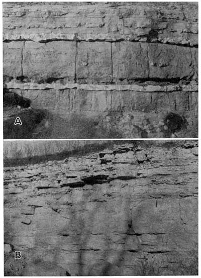
The Three-Mile limestone member, which overlies the Speiser shale, consists of about 7 feet of hard gray limestone in massive beds about a foot thick. The chert occurs in bands or as scattered nodules (Pl. 4). The limestone beds near the middle of the member contain less chert than the upper and lower beds. Brachiopods are the most common fossils in the Three-Mile limestone member.
Plate 4--Exposures of the Wreford limestone. A, Three Mile limestone member exposed in a road cut along the west side of sec. 22, T. 4 S., R. 7 E.; B, Schroyer limestone member exposed in quarry face in the NE NE sec. 16, T. 4 S., R. 7 E. Larger versions of these photos are available.
The Havensville shale member ranges from 14 to 20 feet in thickness in Marshall County. The member is typically a gray to gray-green blocky calcareous shale, but locally it is composed almost entirely of soft thin-bedded gray limestone. Small quartz geodes are generally imbedded in the upper few inches of the member.
The thickness of the Schroyer limestone member ranges from about 10 to 13 feet. The lower 4 or 5 feet of the member is hard, gray, fossiliferous limestone containing only a few thin bands of chert. About 2 feet of buff to brown fossiliferous shale generally separates the relatively noncherty lower bed of limestone from the more cherty upper beds (Pl. 4). The upper 4 to 6 feet of the member consists of beds of tan to buff, hard, fossiliferous limestone containing an abundance of chert.
The Wreford limestone furnishes small to moderate quantities of water to wells in Marshall County. The Three-Mile and the Schroyer limestone members are probably of about equal importance as aquifers. The Havensville shale member does not furnish water to wells.
Matfield Shale
The Matfield shale is divided into three members, which are in ascending order: the Wymore shale member, Kinney limestone member, and the Blue Springs shale member. The average thickness of the formation in Marshall County is about 57 feet.
The Wymore shale member consists of 20 to 23 feet of gray, gray-green, and red-brown shale. Thin discontinuous limestone beds are locally present in the lower part.
The Kinney limestone member consists of 2 to 5 feet of massive to platy gray and yellow limestone. The lower part of this member contains many brachiopods and mollusks.
The Blue Springs shale member consists of about 34 feet of silty varicolored shale. The lower part of the member is generally noncalcareous and contains many gypsum nodules and seams.
The Matfield shale is not known to yield water to wells in Marshall County.
Barneston Limestone
The Barneston limestone, the thickest limestone formation in Marshall County, contains the most massive beds of any formation in the county. The average total thickness of the formation is about 50 feet. It crops out in the bluffs along Big and Little Blue Rivers throughout their courses in the county. The members of the Barneston limestone, in ascending order are: the Florence limestone member, the Oketo shale member, and the Fort Riley limestone member.
The Florence limestone member is easily recognized because of the abundance of chert or flint imbedded in the limestone. In fact, this member is often referred to as the Florence flint. The member is actually a series of beds of limestone and beds of chert (Pl. 5).
Plate 5--Exposures of the Florence limestone member of the Barneston limestone. A, Exposure in road cut near the Cen. sec. 21, T. 3 S., R. 7 E.; B, Lower part of the member showing massive nonflinty bed at base; SE NE sec. 29, T. 4 S., R. 6 E. Larger versions of these photos are available.
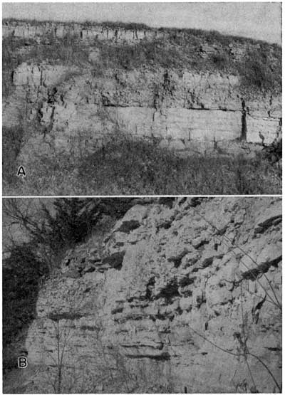
The noncherty beds are generally only slightly thicker than the cherty beds. Many fossils are present in all parts of the Florence limestone member. A rather persistent shale break about 2 feet thick is present in the upper few feet of the member. The Florence is not resistant to weathering and is dissected into steep-sided, rounded hills. The thickness of the member ranges from 22 to 28 feet.
The Oketo shale member, which was named from exposures at Oketo in Marshall County, ranges in thickness from a few inches to more than 6 feet. At most exposures in the county the member consists of hard, gray, calcareous shale containing many brachiopods, crinoids, and echinoid remains.
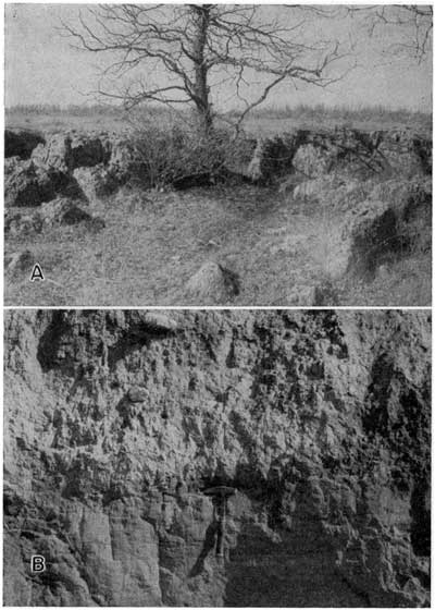
A hard, gray, very massive bed of limestone about 6 feet thick occurs at or near the base of the Fort Riley limestone member in Marshall County. This is the limestone bed that forms the "rim rock" or natural rock wall type of outcrop seen near the top of many hills bordering the valleys of Big Blue and Little Blue Rivers (Pl. 6A). The massive "rim rock" bed is sometimes underlain by as much as 5 feet of impure, thin-bedded limestone and thin beds of shale. The middle part of the member is composed of alternating thin beds of limestone and shale, the shale beds generally being somewhat thicker than the limestone beds. Beds near the top are generally massive, but are soft and much less resistant than the massive beds in the lower part of the member. Weathered exposures of the upper part of the Fort Riley may have a pitted and cavernous appearance. Massive beds of this limestone have been extensively quarried for use as building stone and road material in Marshall County. The average thickness of the member is about 25 feet.
The Barneston limestone is the most important bedrock aquifer in Marshall County; where it underlies long dip slopes, as it does in Western Marshall County, it furnishes large quantities of water to wells. Both the Fort Riley and Florence limestone members are good aquifers. The Oketo shale does not furnish important quantities of water.
Plate 6--A, Natural outcrop of Fort Riley limestone member of the Barneston limestone near the Cen. E. line sec. 34, T. 5 S., R. 6 E., showing "rim rock" type of outcrop; B, Glacial till overlying the Atchison formation in the NW sec. 4, T. 4 S., R. 6 E.; the head of the hammer is resting on the contact. Larger versions of these photos are available.
Doyle Shale
The Doyle shale is composed of two shale members and a limestone member. The members of the Doyle shale, in ascending order are, the Holmesville shale member, the Towanda limestone member, and the Gage shale member. The Doyle shale is the thickest bedrock formation exposed in Marshall County. It is as much as 80 feet thick in western Marshall County.
The Holmesville shale member consists of about 20 feet of green, gray, and maroon calcareous shale. Lenticular limestone beds about a foot thick are present in the lower few feet of the member.
The thickness of the Towanda limestone member ranges from 8 to 13 feet in Marshall County. Beds of gray to yellow platy weathering limestone comprise the bulk of the member. The limestone beds in the upper part of the member may be limonite stained and contain many calcite veinlets. Thin and irregular shale breaks are common in the Towanda limestone member.
The Gage shale member is not well exposed in Marshall County, and the thickness of the member can only be estimated. The total thickness is probably 45 to 50 feet. The lower 35 to 40 feet of the member is composed principally of varicolored unfossiliferous shale. A thin but persistent limestone bed about 10 feet from the top of the member separates the lower varicolored shale from the upper unit of the member which consists of tan, gray, and black fossiliferous shale.
The Towanda limestone member of the Doyle shale yields small quantities of water to wells in Marshall County. The Holmesville and Gage shale members do not yield water in Marshall County.
Winfield Limestone
The members of the Winfield limestone are, in ascending order: the Stovall limestone member, the Grant shale member, and the Cresswell limestone member.
The Stovall limestone member consists of a single bed of hard, gray to tan, cherty limestone. Fossils are not abundant in this member, but echinoid spines and many crinoids are present. The Stovall limestone member is generally about a foot thick, and the presence of an abundance of chert in the thin limestone member makes the unit easily identified.
The Grant shale member consists of about 16 feet of calcareous, silty shale containing many quartz geodes in the upper part. The upper and lower parts of the member are tan to gray in color, and the middle part is gray to red-brown.
The basal part of the Cresswell limestone member consists of 2.5 to 4 feet of rather soft, massive limestone containing many quartz geodes and brachiopod fossils. This massive bed weathers pitted, generally becoming brown to tan splotched with pink. The beds of the Cresswell limestone member overlying this massive bed are not well exposed in Marshall County, but they seem to consist largely of shale and a few impure limestone beds. The total thickness of the Cresswell limestone member is about 15 feet.
The Winfield limestone yields small quantities of water to a few wells in western Marshall County. The Cresswell limestone member is the only part of the formation that yields appreciable quantities of water.
Odell Shale
The Odell shale has a thickness of about 25 feet in Marshall County. The lower 10 feet of the formation consists of alternating bands of red and green shale. The remaining upper 15 feet of the formation is mostly gray shale. Thin, nonpersistent limestone lenses are found in the lower part of the formation at most exposures. Fossils are rare or absent.
The Odell shale is not known to yield water to wells in Marshall County.
Nolans Limestone
The Nolans limestone includes, in ascending order: the Krider limestone member, the Paddock shale member, and the Herington limestone member.
The Krider limestone member, in most exposures, is a sandy-appearing yellowish limestone and is generally rather nodular. In a few exposures the member consists of two thin beds of hard gray limestone separated by a thin bed of shale. The average thickness of the Krider limestone member is about 2 feet.
The Paddock shale member consists of 10 to 13 feet of gray shale and contains several thin limy beds in the upper part. Fossil pelecypods are numerous in the upper part of the member.
The Herington limestone member consists chiefly of yellow, sandy-appearing, resistant limestone containing casts of pelecypods. The massive limestone beds are somewhat dolomitic and contain many quartz geodes. Shaly zones are found throughout the member but are most numerous in the middle part. The average thickness of the Herington limestone member is probably about 6 feet.
The Nolans limestone yields only small quantities of water to wells in Marshall County.
Sumner Group
Wellington Formation
A few inches to as much as 45 feet of varicolored silty and sandy shale overlies the Herington limestone member in extreme west central Marshall County. This shale section represents the basal part of the Wellington formation and is probably the youngest consolidated bedrock in the county.
The Wellington formation does not yield water to wells in Marshall County.
Prev Page--Geologic Formations || Next Page--Quaternary System
Kansas Geological Survey, Geologic History of Kansas
Comments to webadmin@kgs.ku.edu
Web version March 2004. Original publication date March 1954.
URL=http://www.kgs.ku.edu/General/Geology/Marshall/06_geol2.html