![]()
Prev Page--Quaternary System || Next Page--Ground-water Resources, Chemical Character
Structural Geology
A detailed analysis of the structural geology is beyond the scope of this report, but certain aspects of the structural geology are readily discernible and are summarized in the following paragraphs.
Regional Structure
The name "Prairie Plains monocline" (Prosser and Beede, 1904) is applied to the area of eastern Kansas, including Johnson County, and western Missouri where the outcropping Pennsylvanian and Permian rocks dip generally westward and northwestward at about 20 feet per mile. This structure is post-Permian in age. Overstep of Cretaceous rocks, or beveled Permian and Pennsylvanian rocks in eastern Kansas, southeastern Nebraska, and southwestern Iowa, indicates a pre-Cretaceous age for the structure.
Using modern 7-1/2-minute topographic maps having 10-foot contour intervals, many measured geologic sections, and logs of wells and test holes, a map was prepared showing the configuration of the top of the Stanton Limestone (fig. 15). This map indicates that the near-surface rocks dip gently northwestward across Johnson County at an average rate of about 12 feet per mile.
Figure 15--Configuration of the top of the Stanton Limestone. Faults maps on plate 1 are not shown.
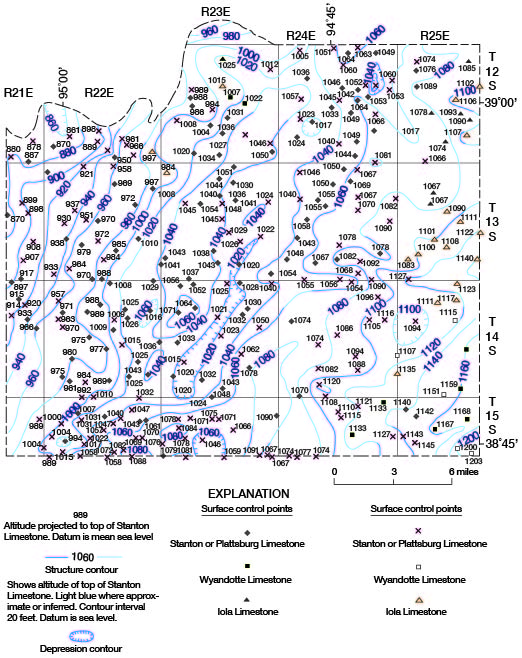
The regional northwesterly dip is modified by a northeast-trending anticline, here named the Gardner anticline, that extends from near Gardner across the central part of the county to near Craig. Much drilling for oil and gas has been on or adjacent to this structure, and the Gardner, Olathe, Olathe North, and Craig-Monticello (in part) fields are on the anticline. There is more than 40 feet of surface closure near the south end of the structure. To the east of the Gardner anticline there is a nearly parallel structural depression. A structure map of the base of the Kansas City Group, not included in this report, shows slightly more closure on the Gardner anticline. Some of the "nosing" structures in the Stilwell and Dallas field areas (fig. 3) appear to have some closure on the base of the Kansas City Group.
Generally, the amount of structural deformation indicated in the surface rocks increases with depth in the older Pennsylvanian rocks, and some of the structural "noses" shown in the surface rocks may become closed anticlines in the Marmaton and Cherokee rocks. Differential compaction and recurrent movement of fault blocks in the basement rocks probably account for most of the structures.
Figure 4 shows the post-Mississippian, pre-Pennsylvanian paleotopography on top of the Mississippian rocks. The map is not a structure map because both the St. Louis and Salem Limestones are exposed directly below the basal Pennsylvanian rocks as a result of post-Mississippian, pre-Pennsylvanian uplift and erosion. In some areas where the topography on the post-Mississippian, pre-Pennsylvanian surface is confined to one formational unit, a contour map on this surface approximates a structure map. The location and altitudes of the top of the Arbuckle for all wells of record that have been drilled into the Arbuckle are also shown on figure 4.
Faulting
Faults have been mapped in only two small areas of Johnson County, in the town of Shawnee and near Cedar. One or more faults strike approximately northeast along an intermittent stream to Nieman Road (east side SE SW sec. 11, T. 12 S., R. 24 E.) and have a throw of as much as 30 feet. Another fault trends south-southeast from Nieman Road (SW SE sec. 11, T. 12 S., R. 24 E.) across Switzer Road to Interstate Highway 35 at 75th Street (SE NW sec. 24, T. 12 S., R. 24 E.) and has a throw of as much as 35 feet. Both faults affect the exposed rocks of the Kansas City and Lansing Groups, but little is known about the effects of the faults on older rocks. Rocks exposed along the faults and in nearby areas of secs. 11 and 14, T. 12 S., R. 24 E., locally have dips of 5 to 10 degrees, and the SW cor. SE sec. 11, T. 12 S., R. 24 E., seems to be the locus of a structural depression associated with the faulting (fig. 15, pl. 1). Three small faults, across Quivira Road just south of 67th Street (west side NW SW sec. 14, T. 12 S., R. 24 E.), in Shawnee were first noted by State Highway Commission geologists.
The south-trending fault near Cedar (sec. 25, T. 12 S., R. 22 E.) is along the east side of Cedar Creek. The Iola Limestone, Lane Shale, and lower Wyandotte Limestone are well exposed in the bluff along the railroad about 1,600 feet east of Cedar Creek; the Iola is just above the track level. About midway between this exposure and Cedar Creek the beds are cut by a fault. In the east bank of Cedar Creek just south of the railroad bridge, the top of the Iola Limestone is in the creek bed and is overlain by good exposures of the Lane Shale and lower Wyandotte beds. Rocks on the west side of the fault are downthrown about 30 feet. Although the trace of the fault is obscure, the difference in altitude of the Wyandotte Limestone along the east and west sides of Cedar Creek valley suggests that the fault may continue southward for a mile or more, but it is concealed by alluvial deposits.
At one other locality along the south county boundary in the valley of Sweetwater Creek (sec. 13, T. 15 S., R. 23 E.) just east of Spring Hill, the Plattsburg, Vilas, and Stanton beds are about 20 to 25 feet higher in the west valley wall than in the east valley wall. This relationship may result from a sharp reversal of dip or from a small north-trending fault, located along Sweetwater Creek, that has a throw of about 25 feet.
Sinks and Depression Structures
Some of the depressions shown on figure 15 may be related to sink holes or collapse structures that have developed in the Mississippian and older Paleozoic rocks. Clair (1943) has indicated a large number of similar depressions on structural maps that he prepared for adjacent Jackson and Cass Counties, Mo. He considered some of these features to be sinks that originated in the pre-Pennsylvanian carbonate rocks and affected the younger Pennsylvanian rocks. Miller (1966) has reported structural features in the surface rocks of Miami County that also may have resulted from solution and collapse.
For the most part, the structures depicted on figure 15 are simpler than those described by Clair in Jackson and Cass Counties, Mo. Two factors account for part of the apparent greater complexity of the geology in Missouri. The first is the greater number of data points, chiefly wells, and the second is the deeper (older) geologic unit on which Clair prepared his maps. The complexity of the structures contoured is greater on the base of the Myrick Station Limestone Member of the Pawnee Limestone as drawn by Clair than on the younger Stanton Limestone in this report. Sink holes in Mississippian and older rocks probably are reflected to a greater degree in the Cherokee and Marmaton rocks than in the younger Lansing rocks.
The thickening and thinning of some of the limestones and shales at shallow depths probably affect the structure in the Stanton Limestone to some degree also. As an example, where the intervals of Lane Shale and Bonner Springs Shale are thick and the Wyandotte Limestone is thin, the sequence of sediments probably has compacted to a greater degree than where the compactable shale units are thin and the more competent Wyandotte Limestone is relatively thick (figs. 6, 7, 10).
Prev Page--Quaternary System || Next Page--Ground-water Resources, Chemical Character
Kansas Geological Survey, Johnson County Geohydrology
Web version April 2002. Original publication date Dec. 1971.
Comments to webadmin@kgs.ku.edu
The URL for this page is http://www.kgs.ku.edu/General/Geology/Johnson/06_struc.html