![]()
Prev Page--Table of Contents || Next Page--Geography
Introduction
Purpose and Scope of Investigation
A study of the geology and groundwater resources of Johnson County was begun in the summer of 1954 by the State Geological Survey of Kansas and the United States Geological Survey in cooperation with the Division of Sanitation of the Kansas State Board of Health (now the Division of Environmental Health of the Kansas State Department of Health) and the Division of Water Resources of the Kansas State Board of Agriculture. In Kansas, water from wells constitutes an important supply for municipal, industrial, irrigation, domestic, and stock needs. This investigation was made to determine the distribution, thickness, and lithologic properties of the outcropping and near-surface rocks and to evaluate the hydrologic properties of the rocks containing potable water in Johnson County.
During the investigation the scope and detail of the report were modified to better meet the needs of the area. Much additional surface and subsurface stratigraphic information was obtained, particularly about the Wyandotte Limestone and adjacent beds because of the commercial importance of limestone quarry rock needed for construction in the rapidly urbanizing Kansas City area.
Because rocks older than Missourian (Pennsylvanian) age are not known to contain potable water, they are considered only briefly in this report. The available quantitative and qualitative data on groundwater from pre-Missourian rocks are summarized from oil and gas exploration data. The structural geologic and mineral resources other than groundwater are also discussed briefly. Data regarding present and potential groundwater developments, together with the effects of pumping on discharge, recharge, and the chemical quality of the water are summarized for the principal aquifers.
Location and Extent of Area
Johnson County is in northeastern Kansas and is bounded on the east by Jackson and Cass Counties, Mo., on the north by Wyandotte and Leavenworth Counties, Kans., on the west by Douglas County, Kans., and on the south by Miami County, Kans. (fig. 1). It includes all or parts of 21 townships, constituting 478 square miles (Batschelet, 1942).
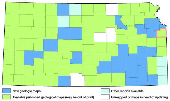
Figure 1--Index map of Kansas showing area described in this report and areas covered by other geologic maps, as of Feb. 2002. For additional information, the KGS Geologic Maps of Kansas Page.
Previous Investigations
The sequence of rocks that crop out in Johnson and adjacent counties has been studied and described by the following geologists: Swallow and Hawn (1865), Haworth (1894, 1895, 1898), Bennett (1896), Keyes (1899), Todd (1909, 1911, 1918), Culbertson (1915), Hinds and Greene (1915), McCourt, Albertson, and Bennett (1917), Schoewe (1923, 1924, l930a, 1930b, 1930c, 1949), Newell (1931, 1933, 1935), Sayre (1931), Moore (1932, 1935, 1949), Greene (1933), Patterson (1933), Jewett and Newell (1935), Hoover (1936), Moore and Landes (1937), McQueen and Greene (1938), Moore, Frye, and Jewett (1944), Frye and Walters (1950), Lins (1950), Zinser (1950), Moore and others (1951), Frye and Leonard (1952), Lamerson (1956), McManus (1956), Mann (1957), Reynolds (1957), Sanders (1959), Eastwood (1958), Wilson (1959), O'Connor (1960), Ball, Ball, and Laughlin (1963), O'Connor and Fowler (1963), and Miller (1966).
Studies relating to the groundwater resources have been made by Bailey (1902), Haworth (1913), Jewett and Williams (1935), Jewett (1939), Moore (1940), Fishel (1948), Fishel, Searcy, and Rainwater (1953), Foley, Smrha and Metzler (1955), Grimes (1957), Dufford (1958), and the Kansas Water Resources Board (1959).
The subsurface geology has been described by McClellan (1930), Ockerman (1935), Lee (1939, 1940, 1943), Lee and others (1946), Lee and Merriam (1954), Merriam, Winchell, and Atkinson (1958), Huffman (1959), Merriam (1960), Merriam and Kelly (1960). The geology pertaining to oil and gas has been discussed by Jewett (1949, 1954), Jewett and Abernathy (1945), and Hilpman (1958). The structural geology and the oil and gas resources in adjacent areas of Jackson and Cass Counties, Mo., have been summarized by Clair (1943). Named geologic structures that have geographic application to Johnson County have been listed by Jewett (1951). Farquhar (1957) has summarized information on the geology of the Precambrian rocks of Kansas. The geologic history has been summarized by Merriam (1963).
Methods of Investigation
The data on which this report is based were obtained chiefly in the summers of 1954 and 1955 during which time wells were inventoried, test holes were drilled, water samples were collected for chemical analysis, and most of the areal geology was mapped. About 4 months of additional field work during 1959-61 included drilling additional test holes, collecting about 200 additional well logs, collecting and checking data points used for the structural maps of the report, completing the geologic mapping, and installing four observation wells.
The geologic and groundwater data collected, and given in reports by earlier workers, were restudied and modified before inclusion in this report. Test holes for this investigation were drilled with a power auger. Drill cuttings were collected in the field and later examined microscopically in the laboratory. Altitudes of wells and test holes were determined with a Paulin surveying altimeter or by interpolation from 7 1/2-minute topographic maps having 10-foot contour intervals.
Well-Numbering System
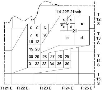
Well and test-hole numbers used in this report give the location of wells according to General Land Office surveys. The well number is composed of township, range, and section numbers, followed by letters that indicate the subdivision of the section in which the well is located. The first letter denotes the quarter section; the second letter denotes the quarter-quarter section, or 40-acre tract; and the third letter, when used, indicates the quarter-quarter-quarter section, or 10-acre tract. The 160-acre, 40-acre, and 10-acre tracts are designated a, b, c, and d in a counter-clockwise 7direction, beginning in the northeast quarter (fig. 2). When two or more wells are located within a 10-acre tract, the wells are numbered serially according to the order in which they were inventoried. For example, well 14-22E-21bcb is in the NW SW NW sec. 21, T. 14 S., R. 22 E., and is the first well inventoried in that tract.
Figure 2--Well-numbering system used in this report.
Acknowledgments
Appreciation is expressed to the many residents of Johnson County who supplied information concerning local geology, wells and water supplies. N.J. Burns of the Kansas State Department of Health and water superintendents of the towns in the area provided information on municipal water supplies. C.F. Gibson of the Kansas State Board of Agriculture provided information on municipal, industrial, and irrigation water supplies.
Breuer Drilling Co., Messrs. Lee Hendee, Sr. and Lee Hendee, Jr., Carl Moore and Son, Fred Spindle, Ernest Lynn, F.E. Young Drilling Co., Cullum and Brown Drilling Co., Boten Drilling Co., Beaty Drilling Co., Layne-Western Co., Union Gas Co., and A.J. Belisle of Gas and Oil Operations provided many useful logs of wells in Johnson and adjacent counties.
Thanks are expressed to Dr. Wallace B. Howe of the Missouri Geological Survey and Water Resources for providing logs of wells drilled in Johnson County, Kans., and adjacent areas of Missouri, and for assistance in field checking geologic features along the State line. L.M. Roper, Hercules Powder Co., kindly permitted access to Sunflower Army Ammunition Plant (formerly Sunflower Ordnance Works) property, and Hugh Jackson, utilities supervisor, furnished data on the ordnance plant water-supply reactivation.
Virgil Burgat, Chief Geologist, and L.W. Fowler, Assistant Chief Geologist of the State Highway Commission of Kansas, made available much useful geologic information, including test-hole logs and unpublished geologic profiles of highway projects in Johnson County.
Stratigraphic sections and other unpublished data on the geologic and groundwater resources of the area collected by many members and former members of the U.S. and State Geological Surveys were utilized in the preparation of this report. The help of these individuals is gratefully acknowledged.
Prev Page--Table of Contents || Next Page--Geography
Kansas Geological Survey, Johnson County Geohydrology
Web version April 2002. Original publication date Dec. 1971.
Comments to webadmin@kgs.ku.edu
The URL for this page is http://www.kgs.ku.edu/General/Geology/Johnson/02_intro.html