![]()
Prev Page--Subsurface Rocks || Next Page--Lansing Group
Stratigraphy of Outcropping Rocks
Pennsylvanian System--Missourian Stage
Kansas City Group--Bronson Subgroup
Swope Limestone
The Swope Limestone is the oldest formation that crops out in Johnson County. It is exposed only in the bed of Indian Creek in secs. 10 and 11, T. 13 S., R. 25 E. The formation comprises three members which are in ascending order: Middle Creek Limestone, Hushpuckney Shale, and Bethany Falls Limestone. The entire formation has a thickness of about 25 feet.
Bethany Falls Limestone Member
The Bethany Falls is about 20 feet thick along Indian Creek just east of the State line in Missouri. Only the upper 5 to 10 feet of the member is exposed locally in and along the creek bed in Kansas. Exposures of this unit are limited and are not shown on plate 1.
Galesburg Shale
The Galesburg Shale is exposed only in and along the bed of Indian Creek (sec. 11, T. 13 S., R. 25 E.). It comprises about 2 feet of medium-gray to medium-bluish-gray argillaceous shale that weathers yellowish to yellowish gray and directly underlies the hard black fissile shale of the Stark Shale Member of the Dennis Limestone.
The thin Canville Limestone Member of the Dennis Limestone is absent in outcrops along Indian Creek in Johnson County and in adjacent Jackson County, Mo., but the Galesburg Shale is readily separable from the overlying Stark Shale Member on the basis of lithology.
Drillers' logs of wells drilled through the Galesburg Shale indicate that the shale ranges in thickness from about 1 to 4 feet. In many drillers' logs the Galesburg Shale and the overlying Stark Shale Member of the Dennis Limestone are not differentiated but are logged as "dark shale." The outcrop of the Galesburg Shale is not extensive enough to show on plate 1.
Dennis Limestone
The Dennis Limestone ranges in thickness from about 28 to 35 feet in outcrops along Indian Creek near the Kansas-Missouri State line. The formation includes one shale and two limestone members in much of eastern Kansas, but the lowermost member, the Canville Limestone, is not identified along Indian Creek or elsewhere in the Kansas City area. A thin limestone, about 1 foot or less thick and in the stratigraphic position of the Canville, is reported in the subsurface of Johnson County in a few well logs.
Stark Shale Member
The Stark Shale Member comprises about 3 to 4 feet of shale, the lower 1 to 2 feet of which is very dark gray to black, fissile, and carbonaceous and contains numerous small gray or brownish-gray elliptical phosphatic concretions ranging in diameter from about 0.5 to 1.5 inches. The dark-gray or black shale is over-lain by about 2 feet of yellowish-gray or light-olive-gray argillaceous slightly calcareous shale. Although fossils are not a conspicuous feature of the Stark, the dark shale contains a few Lingula and conodonts, and the light shale contains a few brachiopods and bryozoans in the Kansas City area.
The only exposures of the member are along Indian Creek in secs. 10 and 11, T. 13 S., R. 25 E. (pl. 1).
Winterset Limestone Member
The upper member and predominant part of the Dennis Limestone is the Winterset Limestone. Good exposures of the Winterset are along Indian and Tomahawk Creeks near the State line, but the complete thickness is not well exposed at any one site. The limestone has a thickness of about 30 feet in the outcrop area and is nearly uniform in thickness in the subsurface.
The lower beds are dark-gray to medium-light-gray or dusky-blue medium- to thick-bedded fine-grained limestone. The rock weathers light gray. Individual limestone beds are uneven to slightly wavy bedded and have clayey partings along some of the bedding planes. The limestone contains fine irregular veins of calcite that Moore (1949, p. 92) ascribed as being of probable algal origin. Near the middle of the Winterset the limestone beds are thin to medium bedded and one or more thin dark-gray or grayish-black shale beds as much as 0.5 foot thick are present. Drillers' logs indicate that dark-gray to black shale in one or more beds in the middle to upper part of the member is as much as 2 feet thick locally.
The upper Winterset beds, 12 to 15 feet thick, comprise gray fine-grained thin- to medium-bedded limestone containing scattered nodules of gray to black chert overlain by very light to light-gray cross-bedded oolite that weathers light olive gray. The dark chert is characteristic of the middle and upper beds in the Kansas City area. Oolitic limestone, several feet thick, at the top of the Winterset crops out in the bed of Tomahawk Creek about 50 feet north of 119th Street (SE SE sec. 16, T. 13 S., R. 25 E.) in Leawood.
The upper Winterset beds contain an abundant fauna that includes many species of mollusks and brachiopods. The lower beds are much less fossiliferous than the upper beds, yet contain a large variety of fossils.
Kansas City Group--Linn Subgroup
Cherryvale Shale
The Cherryvale Shale comprises five members which are, in ascending order: Fontana Shale, Block Limestone, Wea Shale, Westerville Limestone, and Quivira Shale. In its outcrop area the formation ranges in thickness from about 44 to 60 feet.
Fontana Shale Member
The lowermost member of the Cherryvale is generally medium- to dark-gray or greenish-gray argillaceous shale that weathers light olive gray to yellowish gray. It is slightly calcareous and locally contains calcareous nodules. In outcrops along Tomahawk Creek (SW sec. 15, T. 13 S., R. 25 E.) it is 6 to 8 feet thick. Thicknesses reported in well logs range from 2 to 4 feet in the northeast part to 10 to 12 feet in southern parts of the county. Fossils are generally sparse, but near the top of the member the brachiopod Chonetina flemingi occurs in abundance.
Block Limestone Member
The Block is fine-grained gray to bluish-gray limestone that weathers yellowish gray to olive gray. It is a single even bed of limestone 0.5 foot thick in outcrops in the Blue River valley (SE cor. sec. 10, T. 14 S., R. 25 E.) and about 0.5 to 0.8 foot thick along Tomahawk Creek (SW sec. 15, T. 13 S., R. 25 E.). Locally in the subsurface it may be thicker and comprise two or more limestone beds separated by shaly partings.
It is commonly reported to be 2 to 3 feet thick in drillers' logs. The limestone is fossiliferous with brachiopods, crinoids, and fusulinids being most common, and the lower surface contains many Chonetina. It is exposed at only a few localities in Johnson County.
Wea Shale Member
The Wea is commonly the thickest member of the Cherryvale Shale. It is 25 to 35 feet thick in outcrops along Blue River and Tomahawk Creek valleys but is much thinner along the lower part of Mill Creek and along the Kansas River where it ranges in thickness from about 7 to 20 feet. The member is chiefly medium-gray to dark-greenish-gray argillaceous shale. Drillers' logs indicate the presence of red shale and sandy dark-gray to black shale in the Wea in parts of T. 15 S., Rs. 21 to 24 E., in southern Johnson County. Clair (1943, p. 20) has described the "Belton sand" of adjacent Cass County, Mo., as stratigraphically replacing the overlying Westerville Limestone Member of the Cherryvale and all or part of the Wea Shale Member. A gray very fine grained quartzose sandstone in the stratigraphic position of the Wea in parts of Tps. 14 and 15 S., Rs. 24 and 25 E., probably is the "Belton sand" of Clair.
Westerville Limestone Member
The thickness of the Westerville varies considerably in Johnson County. In outcrops in the eastern and northern parts of the county, the member ranges from about 4 feet (SW 1/4 sec. 15, T. 13 S., R. 25 E.,) to more than 19 feet (fig. 5A) in thickness; in the subsurface it ranges from 0 to 30 feet in thickness.
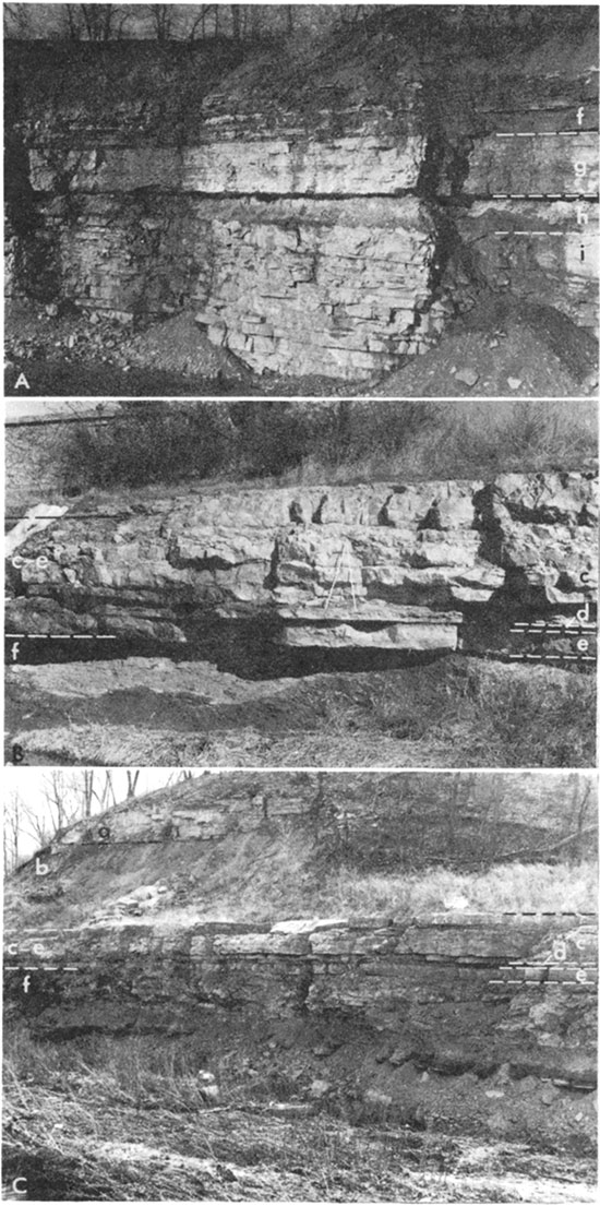
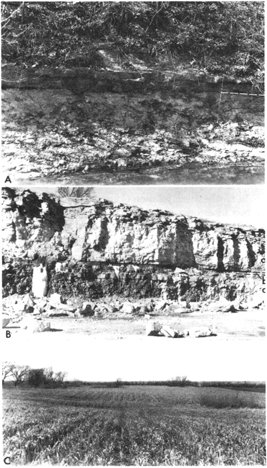
Figure 5--A, Quarry exposure of the Chanute Shale, Drum Limestone, and Cherryvale Shale in the NW NW sec. 35, T. 12 S., R. 25 E. B, Creek exposure of Iola Limestone and Chanute Shale in the SW NW SW sec. 15, T. 12 S., R. 25 E. Folding carpenters rule is 6 feet long. C, Wyandotte Limestone, Lane Shale, Iola Limestone, and Chanute Shale exposed along Turkey Creek in the SE NW sec. 6, T. 12 S., R. 25 E. a, Wyandotte Limestone. b, Lane Shale. c-e, Iola Limestone; c, Raytown Limestone Member, d, Muncie Creek Shale Member, e, Paola Limestone Member. f. Chanute Shale. g, Drum Limestone. h-i, Cherryvale Shale; h, Quivira Shale Member, i, Westerville Limestone Member.
The member has two facies: a lower light-gray to light-greenish-gray fine-grained to sublithographic thin- to medium-bedded limestone that is sparingly fossiliferous, and an upper very light gray crossbedded oolitic limestone containing numerous crinoid, bryozoan, mollusk, and brachiopod remains (fig. 5A). The lower part, termed "Bull ledge" by quarry operators in the Kansas City area, is the more persistent facies and is more uniform in thickness, commonly 3 to 6 feet, whereas the upper oolitic part is highly variable in thickness and distribution. The oolitic part has been called the "Kansas City oolite" by quarrymen and has been used as a building stone in this area. In a few exposures the Westerville has a shaly zone between the oolitic and non-oolitic parts. Along the Kansas River valley northeast of Holliday, in Wyandotte County, about 6 feet of calcareous shale interbedded with nodular and irregular-bedded limestone overlies the crossbedded oolite and is included in the Westerville (Newell, 1935, p. 41).
The Westerville Limestone Member and the Drum Limestone have considerable similarity in lithology and thickness along the Blue River valley but generally can be differentiated by their relation to the overlying and underlying shales, by the presence of Triticites sparsely distributed through the non-oolitic part of the Westerville but absent in the Drum, and by the characteristic coral Caninia torquia in the Drum but not in the Westerville.
Quivira Shale Member
In most exposures the Quivira ranges from 2 to 11 feet in thickness. Commonly the Quivira is thin at localities of thick Westerville (fig. 5A). In nearly all exposures the Quivira consists of three lithologic units. The lower pad is grayish-green or greenish-gray argillaceous shale that contains a few mollusks and, in some exposures, an impure, soft, limy or calcareous zone. The middle unit is dark-gray to grayish-black fissile bituminous shale containing sparse Orbiculoidea. The dark shale commonly is 0.3 to 1.0 foot thick, but locally may be absent. The upper unit of Quivira is green shale and claystone, predominantly argillaceous, but locally calcareous enough to be quite hard.
Bed rather than green shale is reported below the black shale in some well logs in T. 13 S., R. 23 E. Bed shale also is present in outcrops along the east side of sec. 21, T. 13 S., R. 25 E.
Drum Limestone
In Kansas the Drum Limestone consists of the Dewey Limestone Member and the overlying Corbin City Limestone Member. In Johnson County, however, the Dewey Limestone Member represents all, or nearly all, the formation. The Drum ranges in thickness from about 4 to 15 feet, averaging about 10 feet in the northern and central parts of the county and about 5 feet in outcrops along the Blue River and in well logs in T. 15 S.
The Dewey Limestone Member is a massive-appearing limestone ledge in fresh exposures, but upon weathering appears to be thin to medium bedded and wavy (fig. 5A). In outcrops in northern Johnson County the member is medium light gray to light gray and yellowish gray. Much of the rock matrix is very finely crystalline to sublithographic and only sparsely fossiliferous. Locally, small nodules of pyrite 1 to 5 mm (millimeters) in diameter are present in the rock. Clear crystalline calcite is present as veins and nodular masses and as replacement and fillings of fossils. Locally along the Kansas River, Mill Creek, and Tomahawk Creek, the Dewey contains scattered small pink or light-gray chert nodules in the middle or lower part. Along Mill Creek there are chert nodules also in the upper part of the member. Fossils are not abundant in the Dewey, although brachiopods, crinoids, and bryozoans are common; near the top is a persistent zone of the horn coral Caninia torquia. This coral is hot found in the Westerville or the Iola limestone and, therefore, is a useful aid in identifying the Dewey.
The upper member of the Drum is tentatively identified in Johnson County. A coquinoid to suboolitic limestone less than 1 foot thick (generally less than 0.2 foot thick) is separated from the remainder of the Drum Limestone by a parting of a few tenths of a foot of green shale containing Teguiliferina. This upper limestone is considered by Moore (1935, p. 107) to represent the Corbin City Limestone Member, because of its lithologic character and its position as a super limestone of a Missourian Stage megacyclothem. The green shale separating the thin Corbin City from the Dewey is unnamed.
Chanute Shale
Argillaceous, silty, and sandy shale beds and some sandstone beds compose the Chanute Shale (fig. 5A, C). The formation ranges in thickness from about 12 to 32 feet in outcrops, being thinnest along Mill Creek and the Kansas River and thickest along the Blue River in southeastern Johnson County. A maximum of 33 feet of Chanute is indicated in logs of wells drilled in southeastern Johnson County, but elsewhere in the subsurface it is commonly 15 to 25 feet thick. Exposures of Chanute along the Blue River amid Tomahawk Creek, where the thickness of the formation is greatest, show the lower few feet to be grayish-black, dark-greenish-gray, or grayish-blue silty to sandy shale, locally containing small calcareous nodules, overlain by 4 to 6 feet of red to very-dusky-red to purple silty to sandy shale. The red to purple shale is overlain by a few feet of grayish-green to dark-greenish-gray shale, which locally contains a thin impure "marly" limestone as much as 1 foot thick near the base and a thin coal smut at or near the top.
A bed of very fine grained micaceous sandstone, as much as 4 feet thick, locally overlies the greenish-gray shale in parts of Tps. 13 and 14 S., 11. 25 E., just above the middle of the formation. Strata above the sandstone and greenish-gray shale are mostly gray to green sandy to silty shale. A gray coquinoid limestone less than 0.5 foot thick is present locally about 2 feet below the top of the formation in the area south of James Branch along Lee Boulevard in Leawood (SE sec. 3, T. 13 S., R. 25 E.).
In sections exposed along Mill Creek and the Kansas River, the lower half of the Chanute is green argillaceous shale and claystone, overlain by interbedded green and gray calcareous claystone and nodular limestone. The upper half of the formation is green to gray shale and claystone, which locally contains a thin red zone.
In well logs the Chanute is represented chiefly as gray, green, and blue shale, which locally is sandy or includes a thin bed of sandstone. The formation contains a red or purple zone in the southeastern and southern parts of the county. In a few well logs the "marly" impure limestone above the red shale is logged as much as 4 feet thick.
Iola Limestone
The thickness of the Iola Limestone in outcrops ranges from about 6 to 10 feet (fig. 5B,C). The formation includes two limestones and one shale member.
Paola Limestone Member
The Paola is the basal member of the Iola Limestone. It is a dense olive-gray to bluish-gray very fine grained to sublithographic limestone that ranges from 1 to 2.4 feet in thickness. The rock is hard and brittle and breaks with a subconchoidal fracture. The Paola is typically a single bed containing prominent closely spaced vertical joints. The weathered rock is lighter gray than the unweathered rock. Although the basal contact is relatively smooth, the upper contact is highly irregular and pitted. Uneven iron-stained cylindrical tubes of limestone having slightly different texture extend downward a few inches from the top of the member. Within the drainage area of Tomahawk Creek, small medium-gray to grayish-black phosphatic nodules are embedded partly in the upper 0.05 foot of the Paola and partly in the overlying shale member. The presence of the phosphatic nodules embedded in the top of the Paola seems to he restricted to the areas where the overlying Muncie Creek Shale Member is very thin. This feature is well exposed along the small intermittent streams in the N2 SW sec. 20, T. 13 S., R. 25 E., and in the SE SE sec. 30, T. 13 S., R. 25 E.
Although the Paola is fossiliferous, fossils are not always a conspicuous feature of the rock. Cryptozoan algal structures, crinoid fragments, gastropods, cephalopods, and brachiopods are the most common fossils.
Muncie Creek Shale Member
Grayish-black fissile shale containing small (0.5 to 1. inch) ellipsoidal phosphatic concretions is the distinctive and identifying feature of the Muncie Creek Shale Member. At several outcrops of the Iola near Mission Hills, Prairie Village, and Leawood, the Muncie Creek is represented by only 0.1 to 0.2 foot of gray shale, and the grayish-black fissile shale is absent or poorly represented, although the phosphatic nodules are present (fig. 5B, C). Along the Kansas River and Cedar Creek the member is locally 2.2 feet or more thick and consists of three distinct parts. The basal part is 0.1 to 0.3 foot of dark-gray to olive-gray fissile shale with sparse Lingula, The middle part is 1 to 1.5 feet of grayish-black hard fissile shale containing conodonts, sparse Conularia, and the typical grayish-black phosphatic concretions. Upon weathering, the surface of the concretions becomes light gray. The upper part is gray to green shale and blocky-weathering claystone about 0.5 foot thick.
Although the Conularia are not abundant, they probably are much more abundant in the Muncie Creek than in any of the other outcropping strata in the county.
Raytown Limestone Member
The Raytown ranges from 4 to about 14 feet in thickness and averages slightly more than 5 feet. It consists principally of very light gray to medium-gray fine- to medium-crystalline limestone that has slightly uneven or wavy beds, 0.2 to 0.8 foot thick. Thin shale partings locally separate the limestone beds. The basal and most distinctive part of the Raytown in northeastern and northern Johnson County is a thin (0.1 to 0.5 foot) generally light to very light gray calcarenite or calcirudite (Pettijohn, 1957) composed chiefly of crinoid or crinoid and brachiopod fragments (fig. 5B, C). Small amounts of sand-sized fragments of green calcareous clay or shale are associated with the fossil detritus.
In the urban area of northeastern Johnson County, north of Indian Creek, the thin basal crinoidal bed is as useful and distinctive as the phosphatic nodules of the Muncie Creek in discriminating the Iola Limestone from the similar sequence of limestone and shale beds in the lower part of the Wyandotte Limestone. In many poorly exposed outcrops the crinoidal bed can be distinguished and the member identified. The crinoidal calcarenite is separated from the overlying limestone by about 0.1 to 0.5 foot of light- to medium-gray shale.
In outcrops, the main hedge of the Raytown, which is 4 to 6 feet thick, has a mottled appearance because of irregular coloration in the upper beds. Shades of pink, yellow, and gray in irregular patches about 1 to 4 inches in maximum diameter give the limestone a distinctive coloration and account for the term "calico bed" given to it by quarrymen in the Kansas City area. Weathered outcrops of the Raytown become yellowish brown or yellowish orange.
At a few localities along Tomahawk and Indian Creeks, a gray shale bed and a limestone bed overlie the main hedge of the Raytown and locally increase the thickness of the member to about 14 feet. The gray shale may be as much as 3 feet thick and the overlying limestone may be as much as 5 feet thick. These upper limestone and shale beds in the Baytown become more persistent southward in Miami County (Miller, 1966, p. 15, 16).
Productids, especially Linoproductus, Echinaria, and Juresania, are abundant. Neospirifer, crinoid fragments, and several species of bryozoans also are abundant.
Kansas City Group--Zarah Subgroup
Lane Shale
The Lane Shale (fig. 5C) includes the strata, chiefly shale, between the underlying Iola Limestone and the overlying Wyandotte Limestone. The Lane Shale and the overlying Wyandotte Limestone and Bonner Springs Shale compose a complex of shale and limestone beds that varies greatly in thickness and character across Johnson County. Thickening or thinning of the Wyandotte Limestone commonly is accompanied by changes in thickness of the Lane and Bonner Springs Shales. Each of these three units has a much greater range in thickness than any of the other units in the Kansas City and Lansing Groups.
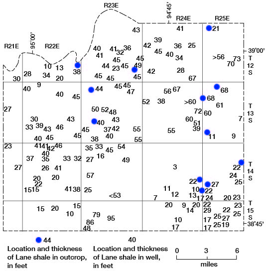
In outcrops the Lane Shale ranges in thickness from about 70 feet in the area south of and along Brush Creek in secs. 15, 21, and 22, T. 12 S., R. 25 E., to 10 feet locally along Tomahawk Creek in the southern part of T. 13 S., R. 25 E., and along Negro Creek in T. 14 S., R. 25 E. (pl. 1). About 68 feet of the formation was measured in sec. 5 and in the SW sec. 7, T. 13 S., R. 25 E. Only the upper part of the Lane is exposed along Little Bull Creek in T. 15 S., R. 23 E., but outcrop measurements and well-log data indicate that the lower Wyandotte beds become lenticular and thin or are absent southward in this area, resulting in an abrupt thickening of the shale between the Iola Limestone and the remaining Wyandotte Limestone. This thickened shale interval is considered to be Lane Shale rather than a Lane-Wyandotte combination following the practice of Newell (1935) and Moore (1935). Therefore, the Lane has a thickness locally of about 95 feet in T. 15 S., R. 23 E. In much of the county the formation is 20 to 50 feet thick (fig. 6).
Figure 6--Thickness of Lane Shale in outcrops and wells.
The Lane Shale is primarily argillaceous and silty shale, but parts of the formation are thin-bedded clay-stone and siltstone that break into blocky or splintery fragments. Where the formation is thick, the middle and upper parts commonly are silty or sandy and locally contain a few feet of very fine grained micaceous sandstone. The silty and sandy beds may be carbonaceous locally. Megascopic marine fossils are sparse or absent in most Lane exposures, but small pelecypods and gastropods locally are common in the upper part. Good specimens of small pelecypods have been collected about 7 feet below the top of the shale in a railroad cut (NE sec. 1, T. 13 S., R. 23 E.) in Mill Creek valley. Ammonites, pelecypods, gastropods, crinoids, brachiopods, and bryozoans are abundant in the upper 2 feet of Lane Shale in a quarry 0.4 mile east of the SW cor. sec. 23, T. 14 S., R. 25 E., along the State line in Missouri. Some of the fossils have been replaced by pyrite.
Scattered small spheroidal or disk-shaped concretions are found locally in the middle or upper parts of the shale. The Lane is medium to moderately dark gray and blue in unweathered outcrops and well samples, but weathered exposures are light gray, yellowish gray, and yellowish orange.
Wyandotte Limestone
The Wyandotte Limestone consists of five members designated, in ascending order: Frisbie Limestone, Quindaro Shale, Argentine Limestone, Island Creek Shale, and Farley Limestone. Although the formation crops out extensively in Johnson County, it cannot everywhere be divided into its five members. It ranges in thickness from a reported maximum of 103 feet in sec. 15, T. 15 S., R. 24 E., to a minimum of possibly 2 feet in the SE cor. sec. 36, T. 13 S., R. 24 E. Along Tomahawk Creek, in the SW cor. T. 13 S., R. 25 E., and the SE cor. T. 13 S., R. 24 E., the formation is less than 5 feet thick. The minimum thickness recorded on well logs is 16 feet (fig. 7). Where the Wyandotte is thin, it is overlain by a thick shale and sandstone section in the Bonner Springs Shale, and is underlain by a thin section of Lane Shale. Because of the Wyandotte's extensive distribution, relatively great thickness, and economic importance as a source of commercially minable limestone in a metropolitan market, the stratigraphy of this unit is described in greater detail than the stratigraphy of other outcropping limestones.
The Wyandotte Limestone, of which the Argentine and Farley Members constitute the dominant part, may be divided into three major facies. The facies have been delineated chiefly from data on the Argentine and Farley Members. A detailed study of the entire formation probably would indicate two or more major facies in the Frisbie, Quindaro, and Island Creek Members also. Areas A, B, and C on figure 7 show the approximate distribution of the three major facies. In areas A and B, the Wyandotte is thick (35 to 103 feet) and contains a high percentage of limestone beds that were deposited in a shallow marine environment that was subject to repeated wave and current agitation. The Wyandotte in areas A and B contains shallow-shelf facies deposited within the zone of wave action--the undathem-type deposits of Rich's (1951) terminology. Most of the Argentine and much of the Farley in areas A and B consist of abundantly fossiliferous thin- to medium-wavy-bedded limestone containing many broken and abraded shells in a fine-gained matrix. Other pants of the two members consist of oolite, coquinite, and pseudo-brecciated algal limestone, which locally exhibit crossbedding or other evidence of wave and current action. The hachured part of area B (fig. 7) is underlain by a thick section of Wyandotte in which 95 percent on more of the formation is limestone. Because of the high proportion of limestone, and perhaps other favorable factors, a karst topography has developed in this local area where the Wyandotte is at or near the hand surface, and several dozen sink holes of various sizes have formed. One of the other factors that may have resulted in karst topography development is that the Wyandotte in area B contains a limestone facies that is somewhat more coarsely textured and contains less shale than the facies in area A.
Figure 7--Thickness of Wyandotte Limestone in outcrops and wells.
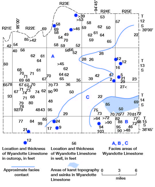
Area C is underlain by a Wyandotte facies deposited chiefly on sloping and deeper parts of the sea floor below the zone of effective wave action--comparable to the clinothem and fondothem deposits of Rich (1951). For the most part, the limestone and shale members in area C cannot be identified and related with any certainty to the named Wyandotte members in areas A and B.
During deposition of thick Wyandotte Limestone material, chiefly carbonates, in areas A and B, only a small amount of carbonate material was being deposited in area C. Some of the shale and sandstone where the Lane and Bonner Springs Shales are thick in area C was deposited contemporaneously with the thick Wyandotte carbonates in areas A and B. A good example of the abrupt lateral change from carbonate to shale, together with a distinct primary dip of the carbonate beds at the edge of the carbonate shelf, can be observed along Coffee Creek in secs. 14 and 23, T. 14 S., R. 24 E., and along Wolf Creek in sec. 34, T. 14 S., R. 24 E.
Frisbie Limestone Member
The type locality of the Frisbie Limestone Member is near Frisbie in northern Johnson County, and the member is typically exposed in a road cut at the east side of the NE NW sec. 17, T. 12 S., R. 23 E. The Frisbie is characteristically dark-gray to medium-light-gray, brownish-gray, or bluish-gray limestone that ranges from about 1 to 5 feet in thickness. In the type locality the member is composed of a single massive bed of dense fine-grained limestone that is 1.5 feet thick. The member contains a sparse fauna of brachiopods and crinoid fragments and more abundant Ottonosia algae and fragments of leaf-like algae represented by veinlets of clear calcite. The base of the limestone is generally even but the upper surface is irregular.
Near Craig, the Frisbie attains the maximum thickness observed in the county. Along the south side of the county road (SW sec. 25 T. 12 S., R. 23 E.) the Frisbie is a massive limestone, 5.1 feet thick, but otherwise is similar to the member in thc type area. Along road exposures near the center of sec. 34, T. 12 S., R. 23 E., the lower part is massive, but the upper part consists of about 0.5 foot of thin fine-grained limestone and shale interbeds overlain by about 0.7 foot of coarse-grained limestone that contains abundant algae and shell fragments in a fine-grained matrix. The Frisbie is about 4.7 feet thick at this exposure. In some exposures the Frisbie has several mound-like structures, or bioherms (Thornbury, 1954), that comprise the upper part of the member (fig. 8A). The lower 1 to 2.5 feet consist of massive medium-gray dense hard calcilutite beds that are jointed vertically and break with sharp edges. Overlying this interval are lense-shaped limestone beds as much as 4 feet thick and 10 to 40 feet wide that have an entirely different character. These beds consist of light- to medium-gray and yellowish-gray poorly bedded brecciated-appearing mottled limestone of the type that has been considered to he of algal origin by many workers. The overlying Quindaro Shale Member is reduced in thickness as a result of the bioherm developments, and the base of the Frisbie is depressed or down warped.
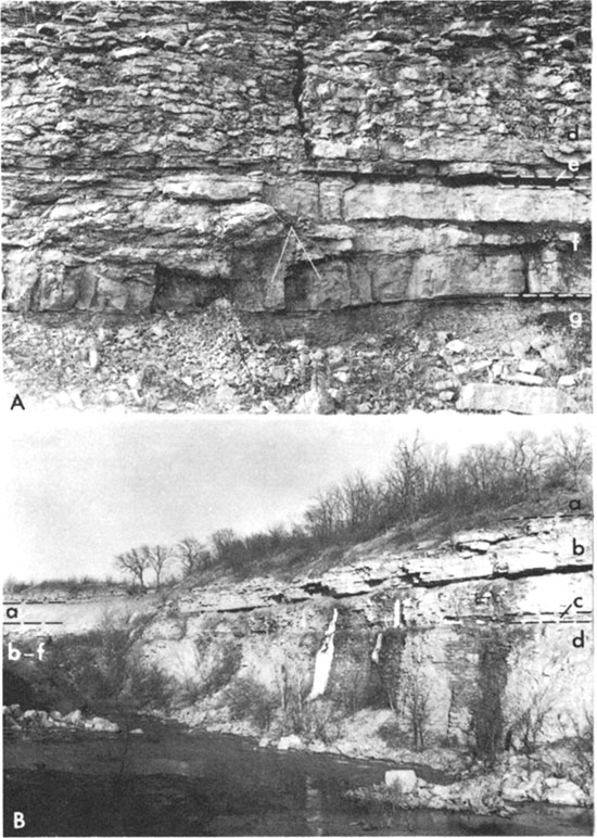
Figure 8--A, Lower part of the Wyandotte Limestone and upper beds of the Lane Shale along the Atchison, Topeka, and Santa Fe Railroad in the NE sec. 1, T. 13 S., R. 23 E. Folding carpenters rule is 6 feet long. B, Bonner Springs Shale and Wyandotte Limestone in a quarry in the SE NW sec. 9, T. 13 S., R. 22 E. a, Bonner Springs Shale. b-f, Wyandotte Limestone; b, Farley Limestone Member, c, Island Creek Shale Member, d, Argentine Limestone Member, e, Quindaro Shale Member, f, Frisbie Limestone Member. g, Lane Shale.
In outcrops in eastern Johnson County within the drainage areas of Turkey Creek, Indian Creek, and Blue River, the Frisbie is less certainly defined inasmuch as the overlying Quindaro Shale Member is absent or gradational with the lower part of the Argentine Limestone Member. However, many outcrops of lower Wyandotte have a very light to medium-gray or grayish-blue dense massive fine-grained limestone, lithologically and paleontologically similar to typical Frisbie, at their base. In the Blue River area, limestone of the basal Wyandotte is less dense, more fossiliferous, and lighter in color, suggesting an environment of deposition different from that of type-locality Frisbie.
In the area drained by Tomahawk Creek, much of the Wyandotte cannot be divided reliably into its five component members, and in parts of this area the Frisbie cannot be identified. Typical Frisbie has not been recognized along Bull Creek and Little Bull Creek in southern Johnson County.
Quindaro Shale Member
The Quindaro Shale Member has a maximum observed thickness of about 7.5 feet along the Kansas River (NW NE sec. 25, T. 12 S., R. 22 E.), but thicknesses of 2 to 5 feet are more common along the Kansas River and in Cedar Creek and Mill Creek drainage areas. Only about 0.3 foot of Quindaro is present in spillway exposures at New Olathe Lake. The Quindaro is absent or doubtfully identified in eastern and southern Johnson County.
Along Turkey Creek in northeastern Johnson County, the lower Wyandotte beds grade upward from a "Frisbie type" limestone to about 0.3 foot of dark-gray shale to about 8 feet of thin-bedded to nodular limestone interbedded with calcareous and fossiliferous shale. The thin dark-gray shale is included in the Quindaro, but the interbedded limestone and shale beds are not easily classified. They are more logically placed with the overlying Argentine Limestone Member.
Along the Kansas River, Cedar Creek, and Mill Creek where the member is best developed, the Quindaro has a thin (0.1 to 0.3 foot) dark-gray shale at the base overlain by several feet of interbedded gray to yellowish-gray and greenish-gray calcareous shale and gray irregular thin-bedded or nodular limestone. Composita, bryozoans, crinoid fragments, sparse sponges, and echinoid fragments are the typical fossils.
Argentine Limestone Member
The Argentine Limestone Member (figs. 8A, B; 9A) is commonly the thickest and most prominent member of the Wyandotte Limestone; it is recognized in the Kill Creek, Cedar Creek, Mill Creek, Turkey Creek, and Blue River drainage areas. The member can be divided into upper and lower distinctive parts. The lower part consists of very light to medium-gray or bluish-gray thin to medium irregular- to wavy-bedded limestone with several very thin, but uneven, gray shale partings; it comprises all but the upper few feet of the member. In some exposures, the shale partings are thicker and more apparent in the lower few feet than elsewhere and tend to mask the contact between the Argentine and the underlying Quindaro. The lower limestone beds of the lower Argentine are aphanitic to finely crystalline, but have recrystallized fossils and void fillings of brownish-gray, olive-gray, or colorless fine- to very coarsely crystalline calcite scattered through the beds. Fossils are abundant and include several brachiopods, namely Composita, Antiquatonia, Echinaria, and Enteletes, ramose and fenestrate bryozoans, and crinoid fragments. Less abundant but still common are small gastropods, small horn corals, and fusulinids. The basal part generally contains a few sponges having an algal coating or overgrowth. The upper part of the lower Argentine locally is gray, pinkish gray, and bluish gray, mottled and brecciated appearing; it probably is partly algal in origin.
Figure 9--A, Massive calcarenite bed in upper part of the Argentine Limestone Member disconformably overlying the irregular-bedded main part of the member in the SE NE NW sec. 31, T. 13 S., R. 23 E. B, Upper part of the Wyandotte Limestone in a quarry in the SW SW sec. 29, T. 13 S., R. 23 E. C, Sink holes in Wyandotte Limestone. View is west from the SW SE SE sec. 30, T. 14 S., R. 25 E. a-c, Wyandotte Limestone; a, Farley Limestone Member, b, Island Creek Shale Member, c, Argentine Limestone Member.
The upper part of the Argentine consists of about 1 to 4 feet of massive coarse-grained calcarenite or more rarely of oolitc, which locally disconformably overlies the finer grained beds (fig. 9A, B). The change in texture and bedding between the lower and upper Argentine beds generally is very sharp in weathered exposures.
The upper Argentine calcarenite is light to medium gray, bluish gray, and light olive gray. It consists chiefly of coated grains (Osagia?) and crinoid and brachiopod remains, and usually has a molluscan fauna, especially Myalina, and large gastropods in the lower part of the bed. Oolite locally forms a part of the massive bed above the molluscan zone and in some exposures limestone beds contain very abundant remains of encrusting algae.
The upper Argentine massive bed and a few feet of the underlying mottled algal limestone are more resistant to weathering than the lower Argentine beds and in some areas make an overhanging bench or ledge along the hillsides. This feature is well developed along the lower part of Cedar Creek valley.
At one locality (NW NW sec. 1, T. 13 S., R. 22 E.) in a quarry exposure, the upper Argentine massive bed is not represented. Overlying the wavy beds of limestone that comprise much of the lower Argentine is about 3 to 4 feet of light-gray to yellowish-gray oolite and calcarenite mixed with calcilutite beds. Overlying this bed is another 3 feet of grayish-blue, pale-red, and medium-light-gray mottled brecciated-appearing algal limestone containing abundant Archaeolithophyllum fragments.
Along Little Bull Creek in the NE sec. 8, T. 15 S., R. 23 E., about 1,000 feet downstream from the section-line road, a limestone about 7 feet thick crops out which may he the facies in area C (fig. 7) equivalent of part of the Argentine. The upper 5 to 6 feet of the 7-foot bed consists of yellowish-gray to light-olive-gray oolitic and molluscan limestone, and the lower 1 to 2 feet consists of greenish-gray and bluish-gray silty limestone that weathers dark yellowish orange. The lower part contains crinoid and brachiopod fragments. This limestone may be a local lenticular bed in the Lane Shale rather than a part of the Wyandotte, but has been included with the Wyandotte, shown as 24 feet thick on figure 7.
Island Creek Shale Member
The Island Creek Shale Member ranges in thickness from less than 1 to 16 feet, but is most commonly 2 to 8 feet thick. The least thickness of well-defined Island Creek measured was 0.4 foot (NE NW sec. 9, T. 13 S., R. 22 E.) and the thickest section measured was 15.5 feet (SW SW sec. 17, T. 12 S., R. 24 E. The member is typically medium- to dark-gray and greenish-gray shale; it commonly is calcareous and clayey in the upper part and silty or sandy in the lower part. Where thin, the member is fossiliferous; Derbyia, Neospirifer, Aviculopinna, Myalina, Bellerophon, Pharkidonotus, crinoids, and bryozoans are abundant. Locally in the DeSoto area, small slender fusulinids are found in the upper part (quarry at NW NW sec. 1, T. 13 S., R. 22 E.). Fusulinids also are abundantly exposed in a quarry north of Stilwell (SW SE sec. 31 T. 14 S., R. 25 E.) and along a railroad cut about 4 miles east of Stilwell in Cass County, Mo., (NW sec. 33, T. 46 N., R. 33 W.).
The Island Creek Shale Member was not identified In areas of Johnson County where the Argentine and Farley Limestone Members could not be differentiated area C, fig. 7)
Farley Limestone Member
The upper member of the Wyandotte Limestone is the Farley, which may comprise a single limestone, or two or three limestones, separated by shale beds (figs. 5B, 9B). The member commonly is 15 to 35 feet thick. In some outcrops the Farley is similar to the Argentine in lithology and thickness. However, in other outcrops the Farley is distinctly more massive, has fewer shale partings, and contains less impurities than the Argentine. It also is less cherty and more crystalline than the Argentine.
In northeastern Johnson County the Farley consists of two limestones separated by several feet of shale. The lower Farley is gray massive medium- to coarse-grained locally oolitic fossiliferous limestone, 3 to 12 feet thick. Shale beds, 7 to 11 feet thick, which are argillaceous in the upper part and sandy and micaceous in the lower part, constitute the middle Farley. The upper Farley is a medium- to dark-gray massive fossiliferous limestone, 2 to 10 feet thick. Locally the upper Farley is a coarse-grained "osagite," or algal calcarenite.
Near Craig, the Farley is about 28 feet thick with massive limestone beds at the top and bottom separated by reddish-gray and brownish-green shale that is interbedded with argillaceous and unfossiliferous limestone beds. This shale is interpreted to be equivalent to the green and maroon clay described by Newell (1935, p. 64, 90) in the SW SW sec. 17, T. 12 S. R. 24 E. The upper massive bed, about 10 feet thick, is coarse-grained oolitic fragmental crossbedded limestone with a very irregular or hummocky upper surface; it overlies about 4.5 feet of yellowish-gray to olive-gray sandy-appearing limestone. The lower bed is gray medium- to thin-bedded fine-grained fossiliferous limestone, about 9.5 feet thick.
Near DeSoto, several unusual exposures of the Farley may he seen in quarries and stream banks. Newell (1935) was the first to call attention to the complex stratigraphy in the DeSoto area, and more recently Wilson (1959) has compiled additional data regarding the stratigraphy of the Wyandotte beds in this area.
About 16 feet of Farley is exposed below the overlying thin (1.1 feet) Bonner Springs Shale in a small quarry along the railroad in the northwest part of DeSoto (SE NE sec. 28, T. 12 S., R. 22 E.). The upper 1 to 3 feet of Farley consists of light-gray to light-yellowish-brown crossbedded oolite and sand-size fossil detritus, which changes laterally along the quarry face to grayish-pink, pale-red, and gray mottled brecciated-appearing algal limestone. Below the oolite about 13 feet of gray, pinkish-gray, and yellowish-gray even to slightly wavy medium-bedded fine-grained limestone is exposed. This limestone contains stringers and veinlets of crystalline calcite that are probably leaflike or matlike remains of algae, or voids filled and partially filled with sparry calcite. Other small voids are filled with a moderate-brown to dark-yellowish-orange earthy limonite.
At this same locality, Newell (1935, p. 68) considered the Bonner Springs Shale to be absent and the oolitic and brecciated-appearing limestone to be the basal bed of the Plattsburg Limestone unconformably overlying the Wyandotte. The normal sequence of beds above the Farley, which has not yet been fully described is the Bonner Springs Shale and the Merriam Limestone, Hickory Creek Shale, and Spring Hill Limestone Members of the Plattsburg Limestone. Newell also considered (1) the upper Farley beds exposed along Kill Creek bridge east of DeSoto to be a breccia bed in the Bonner Springs Shale and (2) the Hickory Creek Shale Member to be 20 feet thick rather than its common thickness of 1 or 2 feet. Wilson (1959) and this writer (this report), utilizing the same exposures as Newell and additional quarry and highway exposures and test-hole data not available to Newell, interpreted the stratigraphy somewhat differently. Wilson identified about 1 foot of Merriam underlain by about 30 feet of Bonner Springs Shale along the Kill Creek road south of the Kansas Highway 10 bridge, and about 20 feet of Farley along the east bank of the creek.
Along the north sides of Kansas Highway 1.0 and of Kill Creek, at the south edge of DeSoto (cen. SE sec. 28, T. 12 S., R. 22 E.), the lower part of the Plattsburg Limestone, including part of the Spring Hill Limestone Member, all the Hickory Creek Shale Member, and all the Merriam Limestone Member, a thin Bonner Springs Shale, and the top of the Farley are exposed. In the creek bank on the south side of the highway about 30 feet of the Farley Limestone Member is well exposed. Farley beds dip eastward as much as 14 degrees locally along the creek, and the local unconformity within the Farley that is seen at the Kill Creek bridge also is exposed. The Farley is approximately 20 feet thick in the DeSoto area and, in addition to its usual fauna of crinoids, bryozoans, and brachiopods, contains abundant fusulinids in the lower part.
In the Blue River valley and its tributaries south of Stanley (southeastern Johnson County), the Farley is part of a nearly continuous limestone sequence that averages 70 to 90 feet thick. At a quarry in the SW SE sec. 31, T. 14 S., R. 25 E., at least 77 feet of Wyandotte Limestone was cored and about 70 feet occurs at the face of the quarry. The Farley at this location is about 31 feet thick and consists of two limestones separated by a thin but variable thickness of shale. The main (lower) Farley lodge comprises about 25 feet of light-gray and light-yellowish-gray limestone that weathers light shades of gray, red, and brown. It is predominantly finely crystalline to sublithographic but has irregular "veins" of crystalline calcite that may be crystallized remains of algae. Brachiopods, especially Composita, and crinoid fragments are sparse to common. The lower 1 foot or less of the Farley contains abundant fusulinids, a feature noted elsewhere, and a thin zone of chert nodules is present 2 or 3 feet above the base. The lower limestone is overlain by light-olive-gray argillaceous shale that ranges in thickness from 0.2 foot to 3 feet. The shale is thickest in the area where the overlying limestone is thin. The shale overlies the main Farley ledge, which has an irregular upper surface with as much as 1.5 feet of relief. The upper limestone bed is pinkish-gray to light-olive-gray granular to crystalline limestone containing voids that are filled or partly filled with sparry calcite. Myalina, gastropods, Composita, and crinoid fragments are the common fossils. The bed ranges in thickness from about 2.3 to 5.6 feet along the face of the quarry. Within this area the Farley, as well as the Argentine, locally has a karst topography (fig. 9C).
In the drainage area of Tomahawk Creek north of Stanley (area C, fig. 7), tile Farley Limestone Member is not recognized locally, or is only doubtfully recognized. About 50 to 100 feet north of the center of the east line of sec. 18, T. 13 S., R. 25 E., along U.S. Highway 69, a light-gray to light-yellowish-gray limestone mottled and speckled with moderate-brown ferruginous clay crops out and is separated from underlying typical Argentine beds by a thin shale. The speckled gray and brown limestone beds probably are a facies of the Farley. The limestone is crossbedded and consists of sand-size grains of crinoid fragments, oolites, pellets, foraminifera, and sparse quartz grains in a finely crystalline calcite matrix. About 1 mile west (NE NE sec. 13, T. 13 S., R. 24 W.) a similar facies of the Farley is exposed. The Wyandotte at this location is about 12 feet thick, and the uppermost few inches locally includes limestone having a speckled gray and brown color and a lithology amid fauna similar to that exposed along U.S. Highway 69. If these beds are correctly interpreted as Farley, the member lies directly on the Argentine, and the Island Creek Shale Member is absent. Elsewhere in the Tomahawk Creek drainage area, as in the NW NE sec. 31, T. 13 S., R. 25 E., the Farley cannot be differentiated, or is doubtfully differentiated, from other thin beds in the Wyandotte Limestone.
Along Little Bull Creek in southern Johnson County (NE NE NW sec. 8, T. 15 S., R. 23 E.) about 9 feet of limestone having two distinct lithologies is exposed along the road below a complete and well-exposed section of Bonner Springs Shale. The upper 2 to 3 feet of limestone is a pale-yellowish-brown to light-olive-gray calcarenite consisting principally of fusulinids, crinoid and echinoid fragments, less abundant brachiopod and gastropod fragments and probably also the algae Epimastopora. Much of the fossil material is recrystallized and the limestone matrix is finely crystalline calcite. Below this calcarenite is about 7 feet of medium-light-gray wavy thin-bedded brecciated-appearing fine-grained limestone mottled with dark-yellowish-orange ferruginous and argillaceous limestone patches. The middle of this lower limestone contains abundant Composita and crinoid fragments; the lower part is poorly exposed.
About 1 mile south (NW cor. sec. 16, T. 15 S., R. 23 E.), below a complete section of Bonner Springs Shale, upper Wyandotte Limestone beds are exposed that have a similar two-fold division of lithologies. The upper 1 to 2 feet (of about 9 feet of limestone exposed) is a calcarenite, somewhat finer grained than noted in the previous exposure. At this location the calcarenite is pale-yellowish-brown to light-brownish-gray slightly sandy limestone that consists primarily of crinoidal remains but includes lesser amounts of Aviculopecten and other clams and gastropods. Brachiopod, bryozoan, and trilobite fragments also were identified. Much of the shell material is recrystallized, and the intergranular space is filled with finely crystalline calcite. The lower beds in the 9-foot exposure consist of medium-light-gray to yellowish-gray slightly mottled irregular to wavy thin-bedded limestone. Blotches and irregular "vein" and cavity fillings of dark-yellowish-orange to grayish-brown limonite or goethite occur irregularly through the limestone, as does void-filling spar calcite. The limestone is predominantly fine-grained calcite. Identifiable fossil material is not common but includes brachiopods, especially Composita, bryozoans, and ostracodes. Much of the limestone is probably of algal origin.
The last two described exposures are within area C (fig. 7) where the Wyandotte members are not easily defined or differentiated. The calcarenite bed in these two exposures may be a part of the Farley because of the abundance of slender fusulinids, which were noted previously near the base of Farley at several other exposures in areas A and B (fig. 7). Limestone beds below the calcarenite cannot be identified definitely as Farley or Argentine on the basis of lithology or fauna.
However, if the calcarenite with abundant fusulinids is basal Farley, the underlying beds probably, are Argentine. It is possible also that the Farley is absent in these two exposures, and that the calcarenite bed with abundant fusulinids and the underlying thin- to irregular-bedded limestone constitute the Argentine Limestone Member of the Wyandotte Limestone.
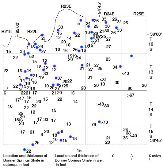
Bonner Springs Shale
The Bonner Springs Shale is a composite unit, consisting predominantly of shale (fig. 5B), which locally includes beds and lenses of sandstone or siltstone and minor amounts of limestone, conglomerate, and coal. In outcrops it ranges in thickness from about 1 foot along the south bluff of the Kansas River at DeSoto (SW NE sec. 28, T. 12 S., R. 22 E.) to more than 70 feet in the SW NW sec. 33, T. 14 S., R. 24 E. In the subsurface it has a thickness of about 80 feet locally in T. 13 S., R. 25 E., and T. 14 S., R. 24 E. (fig. 10). Throughout much of the county, however, it is 15 to 30 feet thick.
Figure 10--Thickness of Bonner Springs Shale in outcrops and wells.
The lower part of the Bonner Springs is characteristically gray or greenish-gray sandstone and gray, blue, or green sandy to silty shale. Carbonized plant fragments are fairly common. The upper part consists of gray and green argillaceous shale, generally with a 0.5- to 2.0-foot red zone 2 to 8 feet below the top. Other beds characteristic of the upper part include a grayish-orange or yellowish-orange and brown impure argillaceous limestone just above the red shale, which Newell (1935, p. 68) described as a "marlite." The "marlite" may have a tinge of green, and in some exposures has a thin basal conglomerate consisting of pebbles of yellowish-orange and brown calcareous mudstone or argillaceous limestone, light-olive-gray mudstone, and light-gray to pinkish-gray fossil fragments, chiefly gastropods and pelecypods. Locally the conglomerate is several feet thick and crossbedded (SE SE sec. 33, T. 12 S., R. 22 E.). In some exposures only the conglomerate (0.1 to 1.0 foot thick) is present. In the DeSoto area along a creek in the east half of the SE sec. 27, T. 12 S., R. 22 E., the Bonner Springs Shale is about 28 feet thick; it is sandy in the lower part.
In some places there is about 1 foot of grayish-green and grayish-yellow silty micaceous impure limestone locally with sand and pebble-size fragments of yellowish-orange calcareous mudstone or argillaceous limestone above the "marlite." Fossils are common and include Composita and other brachiopods, crinoids, Osagia, and Aviculopecten. This limestone is separated from the overlying Plattsburg Limestone by about 1 foot of shale in exposures along the east-west road in the NE NE sec. 23, T. 13 S., R. 24 E., but is directly below the Plattsburg Limestone northeast of the U.S. Highway 50-Interstate Highway 35 interchange (SW SE sec. 12, T. 12 S., R. 24 E.). At the interchange exposure (see measured section, p. 23), the Bonner Springs Shale is complete and is about 33 feet thick. It consists of about 15 feet of bluish-gray silty shale that grades upward into about 12 feet of very flue to fine-grained micaceous quartzose sandstone. This is overlain by about 6 feet of green and gray shale that contains a yellowish-orange-weathering impure nodular limestone or "marlite" near the middle. The "marlite is overlain by silty fossiliferous shale and a thin conglomerate. At the top is an impure silty fossiliferous limy shale with a thin zone of pebbles or "marlite" at its base. Except for the lack of a red shale and a thin coal, this section contains all the common Bonner Springs lithologies. A similar section, about 34 feet thick, is exposed in an east-west road ditch in the NE NE sec. 13, T. 13 S., R. 24 E. This section contains a thin 0.1-foot coal seam in the shale below the conglomerate in the upper part of the formation.
In the area of thick Bonner Springs Shale, which trends generally southwest to south-southwest from T. 13 S., R. 25 E., there is a thin (0.1 foot) coal below a few feet of carbonaceous quartzose sandstone. This coal is above the middle of the formation and may not be the same coal noted previously. It is underlain by 50 feet or more of dark-green amid gray sandy to argillaceous shale. These units are well exposed in a gully about 200 feet east of the section-line road and south of Wolf Creek in the SW NW sec. 33, T. 14 S., R. 24 E.
Along Little Bull Creek (NE NW sec. 8, T. 15 S., R. 23 E.) the Bonner Springs Shale is about 8 feet thick; it consists of gray sandy shale in the lower part, green argillaceous shale in the middle part, and calcareous grayish-yellow shale and a thin yellow impure molluscan limestone in the upper part. At another exposure about 1 mile southeast (NW cor. sec. 16, T. 15 S., R. 23 E.), the Bonner Springs is about 15.5 feet thick and has red shale in the upper part. At several of the southern exposures, the upper 2 or 3 feet of the shale is calcareous and contains Derbyia, Juresania, Aviculopecten, and fragments of Myalina.
In the DeSoto area, previous workers have correlated parts of the Bonner Springs Shale with the Farley Limestone Member of the Wyandotte Limestone and with the Plattsburg Limestone. Changes in the thickness of some units and the thinning or absence of other units have complicated interpretation and correlation of the Bonner Springs Shale and adjacent units in the DeSoto area. The Bonner Springs Shale has a thickness of 20 to 30 feet at the Kansas Highway 10 bridge over Kill Creek (cen. sec. 27, T. 12 S., R. 22 E.) and in the area south and southeast of the bridge for a distance of about 1 mile, The lower three-fourths of the unit contains sandstone and siltstone. The upper fourth is argillaceous silty shale with yellow or brown impure limestone and limestone conglomerate. The conglomerate and upper shale beds are fossiliferous, with gastropods and pelecypods being most abundant.
At a small quarry in the northern part of DeSoto (NW SW NE sec. 28, T. 12 S., R. 22 E.) and also at exposures along Kansas Highway 10 at the south edge of town (NW SE SE sec. 28, T. 12 S., R. 22 E.), the Bonner Springs is only about 1 foot thick. The unit here consists of green and gray shale containing gastropods amid pelecypods and apparently represents only the uppermost beds of the formation.
Along the south side of sec. 33, T. 12 S., R. 22 E., in the east bluff of Kill Creek valley, the Bonner Springs is about 52 feet thick. A 3.5-foot-thick bed of fossiliferous limestone conglomerate occurs about 1 foot below the top of the formation, and a 5.5-foot-thick bed of gray coarse-grained detrital limestone containing abundant shell fragments occurs 15 feet above the base of the formation.
A similar sequence, including thick beds of limestone, breccia, and conglomerate, is exposed along the county road and the government railroad in the NW sec. 4, T. 13 S., R. 22 E., west of Kill Creek. The overlying Plattsburg Limestone is well exposed in a railroad cut. In contrast to Newell's (1935, p. 111) interpretation of the Hickory Creek Shale Member being 20 feet thick amid the Merriam Limestone Member ranging from 0.8 to 15 feet or more at his measured sections 61 and 62 at and near this locality, both members have normal thickness and character. Most of the beds in the Hickory Creek and Merriam that Newell considered to have unusual thicknesses are here considered to be the upper part of the Bonner Springs Shale.
Prev Page--Subsurface Rocks || Next Page--Lansing Group
Kansas Geological Survey, Johnson County Geohydrology
Web version April 2002. Original publication date Dec. 1971.
Comments to webadmin@kgs.ku.edu
The URL for this page is http://www.kgs.ku.edu/General/Geology/Johnson/05_outcr.html