![]()
Prev Page--Geography || Next Page--Kansas City Group
Stratigraphy of Subsurface Rocks
[The classification and nomenclature of rock units used in this report are those of the State Geological Survey of Kansas and differ somewhat from those used by the U.S. Geological Survey.]
Sedimentary rocks of Cambrian, Ordovician, Devonian, Mississippian, Pennsylvanian, Cretaceous (?), and Quaternary age overlie the Precambrian basement in Johnson County. The thickness of Paleozoic rocks ranges from about 2,150 feet near Kenneth in southeastern Johnson County to about 2,550 feet near Edgerton in southwestern Johnson County. The general thickness and character of the subsurface rocks are known through the study of logs and samples of drill cuttings from wells drilled for oil and gas in the area.
An excellent discussion of the stratigraphy and structural development of the Forest City basin, which includes the area of this report, was prepared by Lee (1943). Lee and Merriam (1954) in a geologic section depleted the Paleozoic structural movements that affected the area. Huffman (1959) summarized the major tectonic features that affect the midcontinent region of Kansas and Oklahoma and indicated the stratigraphic and isopachous relations of all pre-Desmoinesian strata, The discussion of pre-Pennsylvanian subsurface stratigraphy is chiefly from these publications.
No detailed subsurface studies in this part of the Forest City basin have been published since Lee's work in 1943. The pre-Pennsylvanian rocks in Johnson County have been penetrated by only a few wells, and potential oil- and gas-bearing strata may yet be discovered in stratigraphic or structural traps in the pre-Mississippian rocks.
Precambrian Rocks
Two wells have been drilled into the Precambrian in Johnson County (Cole and others, 1961). The Kasper No. 1 James (C NL NE NW sec. 8, T. 13 S., R. 25 E.) encountered pink granite below the Cambrian Lamotte Sandstone at 1,412 feet below msl (mean sea level). The Seminole No. 1 Harrington (NE NE SW sec. 12, T. 14 S., R. 22 E.) drilled into biotite granite below Lamotte Sandstone at 1,381 feet below msl.
The Precambrian topography slopes northwestward across Johnson County from about 1,300 feet below msl in the southeast corner to about 1,600 feet below msl in the northwest (Farquhar, 1957).
Cambrian Rocks
The Lamotte Sandstone of Late Cambrian age disconformably overlies the Precambrian and is overlain by the Bonneterre Dolomite. Throughout Johnson County, the Lamotte is believed to be generally less than 40 feet thick and locally it may be absent. It is reported to be 30 feet thick in the Kasper No. 1 James well and 37 feet thick in the Seminole No. 1 Harrington well. The Lamotte is a fine- to coarse-grained sandstone composed chiefly of quartz or quartz and feldspar. It is gradational into the overlying Bonneterre Dolomite. The Bonneterre Dolomite has a thickness of about 100 feet.
Cambrian and Ordovician Rocks
The Arbuckle Group of Late Cambrian and Early Ordovician age consists of four recognizable formations in northeastern Kansas. The lower subdivision of the Arbuckle, of Late Cambrian age, is the Eminence Dolomite. Locally along the Missouri-Kansas boundary, a few feet of Potosi Dolomite may be represented between the Bonneterre and Eminence as a fifth subdivision of the Arbuckle (Lee, 1943). The Eminence ranges from about 150 to 300 feet in thickness. The upper three subdivisions, of Early Ordovician age, are the Gasconade Dolomite (including a slight thickness of Gunter Sandstone Member in the basal part), Roubidoux Formation, and the undifferentiated Cotter and Jefferson City Dolomites. These upper three subdivisions are about 500 feet thick. Except for the Roubidoux Formation, which thickens slightly to the northwest, all tile subdivisions of the Arbuckle and the underlying Bonneterre Dolomite range from about 800 feet in the southeast to about 600 feet in the northwest (Lee, 1943; Huffman, 1959, fig. 2). The Cotter and Jefferson City Dolomites are absent locally, and the Arbuckle section is thin where Simpson-filled channels (McQueen and Greene, 1938) or sink holes (Leatherock, 1945, p. 12; Merriam and Atkinson, 1956), are present in the upper part of the Arbuckle, as in the Kasper No. 1 James well.
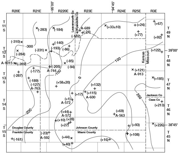
The configuration of tile top of Mississippian rocks and the altitude of the top of the Arbuckle in 10 wells are shown on figure 4.
Figure 4--Configuration of the top of Mississippian rocks, and location and altitude of Mississippian and Arbuckle tops for all wells of record (from records on file at the State Geological Survey of Kansas, January 1963).
Ordovician Rocks
The Simpson Group is distributed throughout the county (Moore and others, 1951, fig. 48). In the Forest City basin of northeastern Kansas, Simpson rocks include the St. Peter Sandstone and the overlying Platteville Formation. The St. Peter Sandstone has been considered as Lower Ordovician by some authors and as Middle Ordovician by other authors and the State Geological Survey. The Platteville Formation is Middle Ordovician in age (Leatherock, 1945). The Simpson of Johnson County consists almost entirely of St. Peter and is about 85 feet thick (Lee, 1943, p. 30).
The greatest thickness of the St. Peter in the Forest City basin also is reported in Johnson County at the Kasper No. 1 James well where a thickness of 403 feet is reported in what probably is a Simpson-filled sink.
The Viola Limestone of Middle Ordovician age overlies the Simpson and is reported to be less than 100 feet thick, except in the northwest corner where slightly more than 100 feet is reported (Huffman, 1959, fig. 4).
The Maquoketa Shale (Upper Ordovician) is reported by Lee (1943) to be absent in Johnson County.
Devonian Rocks
Devonian rocks, which constitute the upper part of the "Hunton Group" in eastern Kansas, overlie the Viola Limestone only in the northern three-fourths of Johnson County (Lee and Merriam, 1954, fig. 2). The beds thicken toward the northwest to nearly 50 feet (Huffman, 1959, fig. 6). The rocks are chiefly dolomite and limestone.
Mississippian or Devonian Rocks
The Chattanooga Shale of Mississippian or Devonian age is green, blue, dark gray, and black and unconformably overlies Viola or "Hunton" rocks in all or most of Johnson County. The Chattanooga Shale may directly overlie the Simpson Group in a small area in the southeastern corner of the county (Lee and Merriam, 1954; Huffman, 1959). It is about 60 feet thick in the northwest corner of the county and thins toward the southeast to about 15 feet (Lee, 1940, pl. 3).
Mississippian Rocks
Mississippian rocks are chiefly limestone and dolomite, parts of which are extremely cherty. The thickest Mississippian section in eastern Kansas probably is in Johnson County where 461 feet has been recognized (Lee, 1940; Huffman, 1959). The rocks thin to about 300 feet in the northwest corner. The subdivisions and their thicknesses recognized in the Kasper No. 1 James well are as follows: Chouteau Limestone, 111 feet; Sedalia Dolomite 30 feet; Burlington Limestone, 145 feet; Warsaw Limestone, 75 feet; Salem limestone, 50 feet; and St. Louis Limestone, 50 feet (Lee, 1940).
The St. Louis Limestone directly underlies Pennsylvanian rocks throughout Johnson County, except in the northwestern and southeastern corners where the Salem Limestone is the uppermost Mississippian formation (Lee and others, 1946, sheet 5).
Pennsylvanian Rocks
Pennsylvanian rocks are represented, in ascending order, by Desmoinesian, Missourian, and Virgilian Stages. The Cherokee and Marmaton Groups constitute the Desmoinesian Stage. The Missourian Stage consists of the Pleasanton, Kansas City, and Lansing Groups. Only the lower part of the Virgilian Stage, the Douglas Group, is represented in Johnson County. Pennsylvanian rocks exposed in Johnson County are discussed in detail on the following pages.
Prev Page--Geography || Next Page--Kansas City Group
Kansas Geological Survey, Johnson County Geohydrology
Web version April 2002. Original publication date Dec. 1971.
Comments to webadmin@kgs.ku.edu
The URL for this page is http://www.kgs.ku.edu/General/Geology/Johnson/04_subs.html