![]()
Prev Page--Geologic History || Next Page--Water Table
Ground Water
Principles of Occurrence
The following discussion on the occurrence of ground water has been adapted from Meinzer (1923, pp. 2-102), and the reader is referred to his report for a more detailed discussion of the subject. For a general discussion of the occurrence of ground water in Kansas the reader is referred to State Geological Survey Bulletin 27 (Moore, 1940).
Ground water, or underground water, is the water that supplies springs and wells. The rocks that form the outer crust of the earth are at very few places solid throughout, but contain numerous open spaces, called voids or interstices. These open spaces are the receptacles that hold the water that is found below the surface of the land and is recovered in part through wells and springs. There are many kinds of rocks, and they differ greatly in the number, size, shape, and arrangement of their interstices and, hence, in their properties as containers of water. Therefore, the character, distribution, and structure of the rocks of any region determine the occurrence of water.
The amount of water that can be stored in any rock depends upon the volume of the rock that is occupied by open spaces, that is, the porosity of the rock. The porosity is expressed as the percentage of the total volume of the rock that is occupied by interstices. A rock is said to be saturated when all its interstices are filled with water. The porosity of a sedimentary rock is controlled by (1) the shape and arrangement of its constituent particles, (2) the degree of assortment of its particles, (3) the cementation and compaction to which it has been subjected since its deposition, (4) the removal of mineral matter through solution by percolating waters, and (5) the fracturing of the rock, resulting in joints and other openings. Well-sorted deposits of unconsolidated silt, sand, or gravel have a high porosity regardless of the size of the grains. Poorly-sorted deposits have a much lower porosity because the small grains fill the voids between the large grains, thus reducing the amount of open space. The pore space in some well-sorted deposits of sand or gravel may gradually be filled with cementing material, thus gradually reducing the porosity.
The capacity of a rock to hold water is determined by its porosity, but its capacity to yield water is determined by its permeability. The permeability of a rock may be defined as its capacity for transmitting water under hydraulic head, and is measured by the rate at which it will transmit water through a given cross section under a given difference of head per unit of distance. Rocks that will not transmit water may be said to be impermeable. Some deposits, such as well-sorted silt or clay, may have a high porosity, but because of the minute size of the pores will transmit water only very slowly. Other deposits, such as well-sorted gravel containing large openings that are freely interconnected, will transmit water very readily.
Part of the water in any deposit is not available to wells because it is held against the force of gravity by molecular attraction--that is, by the cohesion of the water itself and by its adhesion to the walls of the pores. The ratio of the volume of water that a rock will yield by gravity, after being saturated, to its own volume is known as the specific yield of the rock.
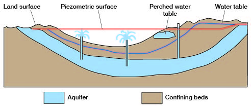
Below a certain level, which in Finney and Gray counties ranges from the surface to about 210 feet below the surface, the permeable rocks are saturated with water under hydrostatic pressure. These saturated rocks are said to be in the zone of saturation, and the upper surface of this zone is called the water table. Wells dug or drilled into the zone of saturation will become filled with ground water to the level of the water table.
The permeable rocks that lie above the zone of saturation are said to be in the zone of aeration. As water from the surface percolates slowly downward to the zone of saturation, part of it is held in the zone of aeration by the molecular attraction of the walls of the open spaces through which it passes. In fine-grained material there is invariably a moist belt in the zone of aeration just above the water table, and this moist belt is known as the capillary fringe. Although water in the zone of aeration is not available to wells, much of the water in the upper part of the zone may be withdrawn by the transpiration of plants and by evaporation from the soil.
Rock Types and their Water-bearing Properties
The outer crust of the earth is made up of various kinds of material ranging from unconsolidated deposits such as clay, silt, sand, and gravel to consolidated rocks such as shale, limestone, and sandstone. All of these materials, whether they are firm and hard or loose and soft, are called "rocks." All of the rocks encountered in drilling wells in Finney and Gray counties are of sedimentary origin. There are, however, many different types of sedimentary rocks that range greatly in character and in their ability to store and transmit water. The chief types of sedimentary rocks encountered in this area are clay, silt, sand, gravel, sandstone, limestone, and shale. A brief discussion of the water-bearing properties of each is given below.
Sand and Gravel
In Finney and Gray counties more wells obtain water from sand and gravel than from any other source. Unconsolidated deposits of sand and gravel are found in the alluvium in all of the larger stream valleys, in the Pleistocene terrace deposits, in the undifferentiated Pleistocene deposits, and in the Ogallala formation.
Gravel is far superior to any other type of material in its ability to store and yield water. A great range in the water-bearing properties of various kinds of gravel is found, however. This difference is controlled by the degree of assortment and the degree of cementation of the gravel. Coarse, clean, well-sorted gravel has a high porosity, high permeability, and high specific yield. It has the ability to absorb water readily, to store it in large quantities, and to yield it to wells freely. In some deposits, however, clay, silt, or sand is mixed with the gravel, thus reducing its porosity, permeability, and specific yield. Most of the gravel deposits in Finney and Gray counties contain some silt and sand, but nevertheless yield water very freely. Some of the gravel deposits in the undifferentiated Pleistocene deposits and the Ogallala formation have been tightly cemented with a lime carbonate, thus making them worthless as producers of water. The tightly cemented zones are relatively thin, however.
Sand ranks next to gravel as a water bearer. The same factors causing variations in the water-bearing properties of gravels will cause variations in the water-bearing properties of sand. Sand differs from gravel in having smaller interstices; therefore, it will conduct water less readily and will give up a smaller proportion of its water to wells. Sand also consists of smaller particles, which are more readily carried by the water into the wells, thus causing difficult problems in connection with drilling and pumping. Proper well construction is especially important where the main source of water is from fine sand. A discussion of well construction is given on page 92.
The distribution, character, thickness, and water-yielding capacity of the sand and gravel deposits in this area are described under the chapter on geologic formations and their water-bearing properties.
Sandstone
The Dakota formation contains the only water-bearing sandstones tapped by shallow wells in this area. All of the wells tapping the Dakota formation in this area are in southeastern Gray County, and supply water for domestic and stock use. Sandstones also occur in the underlying Cheyenne sandstones, but no water wells are known to tap the Cheyenne in this area.
Sandstone ranks next to sand in its ability to store and transmit water. The factors determining the water-bearing properties of a sandstone are the size of grain, degree of assortment, and degree of cementation. A coarse-grained well-sorted sandstone generally will yield water freely, whereas an equally well-sorted very fine-grained sandstone holds a relatively large part of its water and surrenders the rest very slowly. A loosely cemented very fine-grained sandstone also is undesirable because of the tendency of the grains to enter wells, thus causing damage to the pumps and often clogging the wells (see page 93). The degree of assortment of the sand grains in a sandstone affects the water-bearing properties of the sandstone in the same way as in a gravel deposit. Fine sand, silt, or clay in a coarse-grained sandstone greatly decreases the porosity and permeability of the sandstone. The interstices of sandstone are small and are, therefore, easily closed by precipitates from percolating water. Many sandstones are so thoroughly cemented that they will not yield water from the original openings between their grains. Tightly cemented sandstone may, however, contain joints and fractures that hold water.
Sandstones in the Dakota formation range considerably in their capacity as water-bearers. A complete discussion of the character and water supply of the Dakota formation is given on pages 145-148 of this report.
Limestone
Limestone, although inferior in this area to gravel, sand, or sandstone as a water bearer, supplies water to a few wells in this area where the more desirable types of rocks are absent or where they lie above the water table and are therefore barren of water. Such wells tap limestones in the Fort Hays limestone member of the Niobrara formation (p. 159). This limestone member also supplies water to several springs in the northeastern part of Finney County (p.160).
Water occurs in limestone in fractures or in solution openings that have been dissolved out of the rock by water containing dissolved carbon dioxide. The occurrence of fractures and solution openings is very irregular, making it difficult to predict where water will be found in a limestone. One well drilled to limestone may encounter water-filled fractures or solution openings and have a good yield, whereas another well drilled only a few feet from the first well may not encounter any fractures or solution openings and yield little or no water. In drilling for water in an area underlain by limestone, it is generally necessary to put down several test holes to locate water-bearing fractures or solution openings before the final well can be drilled.
Shale
Several wells in this area obtain all or a part of their water from shale. All of the wells known to obtain water from shale tap the Blue Hill shale member of the Carlile shale. Most of the wells have very small yields. Shales occur in all of the Cretaceous formations in this area. Shale is one of the most unfavorable of rocks from which to obtain water. Shale, if not too tightly indurated, may have a fairly high porosity and contain much water. The interstices between the individual particles are so small, however, that the water is held by molecular attraction and hence is not available to wells. Available water in shale is found only in joints and along bedding planes. Descriptions of various shales encountered by drilling in this area are given in the chapter on geologic formations and their water-bearing properties.
Permeability of the Water-bearing Materials
The permeability of a water-bearing material--that is, its capacity to transmit water under hydraulic head--may be determined in the field by tests of ground-water velocity or by discharging-well methods.
Ground-water Velocity Method
In 1904, Slichter (1906, pp. 7-16) made tests of the velocity of the underflow in the Arkansas valley 2 miles west of Garden City and at Holcomb (referred to as Sherlock in Slichter's report) in Finney County. The method developed and used by Slichter consists of driving several small wells into the water-bearing formation in such a manner that the movement of water is from one well toward one or more of the other wells. A salt is introduced into the up-gradient well and the electrolyte thus formed is allowed to move down-gradient toward the other wells, where its arrival is detected electrically. The rate of movement of the electrolyte and hence the rate of movement of the ground water is computed from the elapsed time between the introduction of the salt in the up-gradient well and its detection in a well located downgradient. Slichter made several tests at each location and found that the natural velocity of the ground water 2 miles west of Garden City ranged from 1.3 to 10.3 feet per day and averaged 6 .6 feet per day. He found that the natural velocity of the ground water at Holcomb ranged from 2.0 to 22.9 feet per day and averaged 8.9 feet per day. The wells used in making the velocity tests ranged from 11 to 65 feet in depth, and tapped only the alluvial deposits of the valley.
Slichter did not compute permeability after determining the natural velocity of the ground water. Permeability can be computed, however, by using the equation Pm = (7.48 pvCt)/I, in which Pm is Meinzer's coefficient of permeability, p is the porosity of the water-bearing material, v is the velocity of the ground water in feet per day, and I is the hydraulic gradient in feet per foot (Wenzel, 1942, p. 71). The coefficient of permeability as defined by Meinzer is expressed as the number of gallons of water a day, at 60 deg. F., that is conducted laterally through each mile of the water-bearing bed under investigation (measured at right angles to the direction of flow), for each foot of thickness of the bed, and for each foot per mile of hydraulic gradient (Stearns, 1927, p. 148).
The average hydraulic gradient 2 miles west of Garden City is 7.5 feet to the mile or 0.00142 foot per foot, and the average velocity of the ground water as determined by Slichter was 6.6 feet per day. The temperature of the ground waters in the area where Slichter's work was done averages about 60 deg. F., so that no correction for temperature is needed. By using an assumed porosity of 30 percent and substituting these values in the above equation, the coefficient of permeability of the water-bearing materials 2 miles west of Garden City is computed to be about 10,400.
Using the same equation, but substituting 8.9 feet per day for v, the coefficient of permeability of the water-bearing material at Holcomb is computed to be about 14,000.
Theis Recevery Method
Theis (1935) developed the following formula for determining permeability from the recovery of the water level in a well:
T = (264q/s) log10 (t/t1)
in which T = coefficient of transmissibility
q = pumping rate (in gallons a minute)
t = time since pumping began (in minutes)
t1 = time since pumping stopped (in minutes)
s = residual drawdown at the pumped well (in feet) at time t1
The coefficient of transmissibility is the product of the field coefficient* of permeability and the thickness of the saturated portion of the aquifer. The Theis formula is based on the assumption that if a well is pumped at a constant rate of discharge for a known period and then left to recover, the residual drawdown at any instant will be the same as if the discharge of the well had been continued, but a recharge well having the same (flow) had been introduced at the same point at the instant the discharge actually stopped (Wenzel, 1942, p. 95). It does not assume equilibrium conditions.
(* - The field coefficient of permeability differs from Meinzer's definition of coefficient of permeability chiefly in that it does not include a temperature correction.)
The value of (log10 t/t1)/s is determined graphically by plotting log10 t/t1 against corresponding values of s. Most of the points should fall on a straight line and this straight line should pass through the origin. If the straight line does not pass through the origin, it may be made to do so by empirically applying a correction factor to t. With the empirical correction factor the Theis formula is as follows:
T = (264q/s) log10 [(t +/- c)/t1]
where c is the value whose magnitude is such that the straight line determined by plotting log10 [t +/- c)/t1] against s will pass through the origin (Wenzel, 1942, p. 96).
Pumping tests to determine the permeability of the water-bearing material by the Theis recovery method were made on six wells in the Finney-Gray area. The field tests were conducted by Woodrow Wilson, of the Federal Geological Survey, and Melvin Scanlan, of the Division of Water Resources, Kansas State Board of Agriculture. The results of one test were obviously in error so they have been omitted from this discussion. In computing the results of the other five tests, it was necessary to apply the correction factor to make the straight lines pass through the origin. The results of the five tests are given in table 4.
Table 4--Results of pumping tests made on wells in Finney and Gray counties using the Theis recovery method for determining permeability
| Well number and/or location | Water-bearing formation | Length of time well was pumped (minutes) | Average discharge of well during test (gallons a minute) (g) | Specific capacity (gallons a minute per foot of drawdown) | Correction applied to t (c) | Coefficient of transmissibility | Approximate thickness of water-bearing beds | Coefficient of permeability (1) (Pf) |
|---|---|---|---|---|---|---|---|---|
| Well 454, NW NW sec. 10, T. 26 S., R. 28 W. | Alluvium | 225 | 592 | 35 | -210 | 38,200 | 37 | 1,030 |
| Well 160, SW SE sec. 36, T. 23 S., R. 34 W. | Alluvium and undifferentiated Pliocene and Pleistocene deposits | 170 | 1141 | 32 | -95 | 64,000 | 160 | 400 |
| Well 450, SE cor. NW sec. 17, T. 26 S., R. 27 W. | Alluvium and undifferentiated Pliocene and Pleistocene deposits | 210 | 970 | 46 | 500 | 154,185 | 148 | 1,040 |
| U.S. Army well, NW NW SW sec. 27, T. 24 S., R. 31 W. (2) | Undifferentiated Pliocene and Pleistocene deposits | 307 | 441 | 33 | 325 | 47,500 | 120 | 395 |
| U.S. Army well, NE NW SE sec. 27, T. 24 S., R. 31 W. (2) | Undifferentiated Pliocene and Pleistocene deposits | 338 | 272 | 12 | -170 | 27,000 | 116 | 235 |
1. The temperature of the ground water in Finney and Gray counties ranges from 57 deg. to 62 deg. F. Corrections for temperature have been omitted because they would not materially alter the results.
2. Well drilled after the field investigation was completed.
Summary
The coefficients of permeability of the alluvium in the Arkansas valley determined by using the ground-water velocity method were 10,400 and 14,000, as compared with 1,030 computed for well 454 by the Theis recovery method. The latter figure, 1,030, is probably more nearly of the right order of magnitude. Certain inherent errors of the ground-water velocity method as used by Slichter may be pointed out. Errors in determining the velocity of the ground water may have been caused by an increase in the hydraulic gradient caused by the rise of water in the up-gradient well at the time the salt was introduced and by the fact that the water-bearing material under study is highly lenticular, allowing greater velocity along certain "pipes" of more permeable material. The wide range in velocities obtained by Slichter indicates that certain measurements were made along "pipes" of this kind, and other measurements were made along "pipes" of material having a very low permeability. For lenticular material of this type, it would be very difficult to evaluate the ground-water velocities obtained in order to arrive at an average velocity.
Wells 160 and 450 tap the same water-bearing formations, but the computed coefficient of permeability of the material at well 450 is about 2 1/2 times greater than that of the material at well 160. A comparison of the specific capacities and the thickness of water-bearing materials at the two wells also show that the water-bearing material at well 450 has a greater permeability than the material at well 160. Well 160 has a specific capacity of 32, and the thickness of the water-bearing material is about 160 feet; whereas the thickness of water-bearing material at well 450 is about 148 feet, yet well 450 has a specific capacity of 46.
Artesian Conditions
Artesian water is ground water under sufficient pressure to rise above the point at which it is encountered in wells. A well that flows at the land surface is known as a flowing artesian well.
Artesian conditions exist where a water-bearing bed is overlain by an impermeable or relatively impermeable bed that dips from its outcrop to the discharge area (Sayre, 1937, p. 22). Water enters the water-bearing bed at the outcrop and percolates slowly downward to be held in the water-bearing bed by the overlying confining bed. Down the dip from the outcrop area, the water exerts considerable pressure against the confining bed. When a well is drilled through the confining bed into the water-bearing bed the pressure is released and the water rises in the well. If the water is under sufficient pressure, and if the altitude of the land surface is lower than the altitude of the outcrop of the water-bearing bed, the water may rise high enough to flow at the surface. In places where there are lenses or beds of relatively impermeable clay or silt at the level of the water table, the water encountered below such lenses or beds will rise to the level of the surrounding water table, but such water is under normal pressure and is not artesian.
There is only one flowing well (119) in this area to my knowledge. It is on the R.J. Ackley land in the SW SW sec. 4, T. 23 S., R. 33 W., and is reported to be between 70 and 80 feet deep. Figure 10 illustrates the probable geologic conditions that cause this well to flow. Well A in the illustration is situated on the uplands under normal water-table conditions. Well B, however, is situated in a depression, the surface of which is below the water table. Water encountered in the sands and gravels below the lens of impermeable silt or clay will rise above the land surface to the level of the surrounding water table. Such water is under normal pressure and is not artesian. Well 119 furnishes water to a pond which covers a part of the depression. The level of the water in the pond probably is below the level of the surrounding water table, for the amount of water lost by transpiration and evaporation is greater than the amount of water supplied by the well. If no water were lost through transpiration and evaporation, the water level in the pond should be at the same level as the surrounding water table.
Figure 10--Diagrammatic geologic section across an upland depression showing relationship between a flowing well and and non-flowing well.
Artesian water has been encountered by wells in areas adjacent to the Finney-Gray area. The largest area of flowing wells in the state is in the Meade basin in central Meade County, which adjoins Gray County on the south. There were more than 200 flowing wells in the Meade district in 1939 (Frye, 1942, p. 52). Most of the artesian water in the Meade basin is obtained from Pliocene deposits, but some comes from Pleistocene beds. According to Frye (1942, p. 49):
"... alternate beds of permeable and relatively impermeable material dip downward beneath the floor of the Meade artesian basin. Water entering the permeable strata northwest of this area at an elevation higher than the floor of the basin moves down the dip between the confining layers of relatively impervious material toward the lowest part of the basin, where it is under artesian pressure."
Small flowing wells in southwestern Ford County obtain artesian water from the Rexroad member of the Ogallala formation (Pliocene) and from overlying Pleistocene beds (Waite, 1942, p. 50). Waite (1942, p. 50) also reports a small flowing well in the Arkansas valley, about 3 miles east of the Gray-Ford County line, which obtains artesian water from the Ogallala formation. The Dakota formation (Cretaceous) supplies artesian water to wells in some areas. Moss (1932, pp. 45, 46) reports that there are several flowing wells from the Dakota formation in Sawlog creek valley in southern Hodgeman County.
Prev Page--Geologic History || Next Page--Water Table
Kansas Geological Survey, Geology
Web version April 2002. Original publication date Dec. 1944.
Comments to webadmin@kgs.ku.edu
The URL for this page is http://www.kgs.ku.edu/General/Geology/Finney/06_gw.html