![]()
Prev Page--Introduction || Next Page--Geology
Geography
Topography and Drainage
All of the area herein described lies in the High Plains section of the Great Plains physiographic province except the northeastern or panhandle part of Finney County, which lies in the Plains Border section. The total relief of the area is approximately 640 feet. The highest point, the northwestern corner of Finney County, has an altitude of about 3,090 feet, and the lowest point, where Pawnee River leaves the area, has an altitude of about 2,450 feet. Locally, however, the relief does not exceed 300 feet.
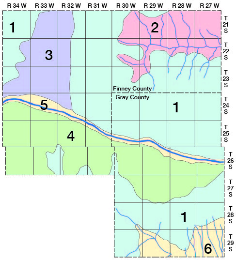
The area may be divided into six physiographic divisions, which exhibit differences in topography, drainage, and origin (fig. 2)--upland plains, Pawnee River drainage basin, Crooked Creek drainage basin, Finney basin, sand hills, and the Arkansas valley area. These divisions are similar to those proposed by Smith (1940, pp. 140, 141). Descriptions of each division are given below and explanations of origin are discussed in the section on geologic history.
Figure 2--Map of Finney and Gray counties showing physiographic divisions. (1) Upland plains; (2) Pawnee river drainage basin; (3) Finney basin; (4) sand hills; (5) Arkansas valley area; and (6) Crooked creek drainage basin.
Upland plains--More than a third of the total area in Finney and Gray counties consists of nearly flat to gently rolling upland plains, which slope toward the east at an average gradient of less than 10 feet to the mile. Two areas of upland plains are separated by the Arkansas valley and by the sand hills bordering the Arkansas valley on the south (fig. 2). The uplands north of the Arkansas valley begin at the prominent escarpment in the eastern side of the Finney basin and slope very gently eastward at an average gradient of about 7.5 feet to the mile. The area south of the Arkansas valley is a broad, flat area bounded on the north by low-lying sand hills and on the south by the Crooked Creek drainage basin. The slope of the surface is more gentle than the slope of the upland surface north of the valley, and averages only about 5 feet to the mile.
A common feature of the nearly flat upland plains is the occurrence of many shallow undrained depressions which range in diameter from a few tens of feet to more than a mile. Short tributaries lead into many of these depressions from any or all directions. After heavy rains many of the depressions hold water, thus becoming temporary lakes or ponds. The relation of these depressions to ground-water recharge is discussed on page 73. The flatness of the upland plains is in some places broken by accumulations of windblown sand (pl. 1). Such areas, however, are of small extent and do not compare with the large area of sand hills south of the Arkansas valley.
Pawnee River drainage basin--This physiographic division comprises that area in the "panhandle" of Finney County that is drained by Pawnee River and its tributaries. The surface of this area was at one time continuous with that of the upland plains, but has since been deeply dissected by Pawnee River and its tributaries. Erosion has cut below the Tertiary silts, sands, and gravels, and has exposed shale (Carlile) and limestone (Niobrara formation) of Cretaceous age (pl. 1) resulting in a rugged topography having a local relief of more than 250 feet. The Carlile shale, which is exposed on both sides of the Pawnee valley, has been reduced to moderate slopes which in many places are nearly barren of vegetation. On the north side of the valley, the Carlile shale is overlain by limestone (Niobrara formation) which makes a prominent escarpment above the moderate shale slopes. Limestone is not present on the south side of the valley, so the slopes are gentle to moderate except where the shale is capped by "mortar beds" of the Ogallala formation which form an escarpment similar to that formed by limestone.
The Pawnee valley proper ranges in width from a quarter of a mile to more than a mile and is bordered by an unusually large number of short, narrow tributary valleys. Pawnee River is characterized by a shallow channel and relatively broad meanders. After leaving Finney County, Pawnee River flows eastward and joins Arkansas River at Lamed in Pawnee County.
Crooked Creek drainage basin--In the southern part of Gray County, Crooked Creek and its tributaries have cut their valleys down below the general level of the high plains, producing an area of many small valleys and narrow divides. The total relief in this dissected area is about 250 feet; however, the maximum local relief does not exceed 150 feet and is much less than this in most places. The tributary valleys are short and straight and have roughly V-shaped cross-profiles. The divides between the tributary valleys are narrow, flat areas seldom more than 1 or 2 miles in width, and have southward-sloping axes.
Crooked Creek in this part of its course is an ephemeral stream, which flows only after rains. Its valley is relatively flat and ranges from an eighth to a half of a mile in width, including in places a narrow terrace that is 5 to 10 feet above the general level of the flood plain. Crooked Creek heads in east-central Haskell County and flows southeastward across the southwestern part of Gray County. After crossing the county line it swings northeastward into southwestern Ford County where it makes a "hairpin" turn and flows south-southwestward through Meade County. In south-central Meade County, it turns again and flows southeastward finally joining Cimarron River in Oklahoma.
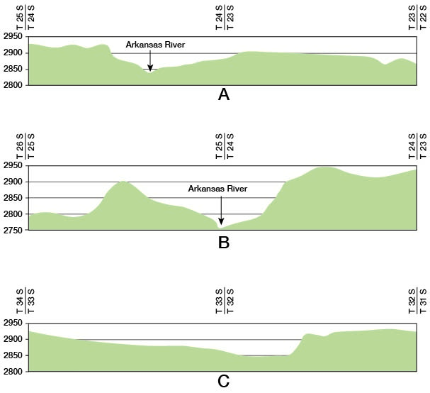
Finney basin--The Finney basin is a broad, shallow depression in the northwestern part of Finney County extending from the Arkansas valley northward into Scott County. It is continuous with the Scott basin* (Waite, in press) of central Scott County. The eastern limit of the depression is in most places abrupt, being marked by a conspicuous escarpment which is 50 feet or more high. On the west, however, there is no sharp limit to the depression. Its western flank slopes upward gradually to merge with the High Plains surface. Thus, it is an asymmetrical depression (fig. 3C).
Figure 3--Topographic profiles of Finney County. A--North-south profiles 2 miles east of Holcomb; B--North-south profile along west side of Range 31 W; C--East-west profile across the Finney basin, 5 miles north of Garden City.
The Finney basin is topographically continuous with the Arkansas valley although there is no surface drainage from the Finney basin into the Arkansas valley (Smith, 1940, p. 19). Short, ephemeral streams flowing southeastward from Kearny County gradually disappear on the west slope of this depression. The importance of such streams to the recharge of the ground-water reservoir is discussed on page 77. Superimposed on the surface of this large depression are many small shallow depressions and marshy areas (pl. 3A) which, like those on the upland surface, temporarily hold water after rains.
Sand hills--Bordering the Arkansas valley on the south is a wide lowland belt covered by sand hills that is intermediate in level between the river valley on the north and the upland plains on the south (pl. 3C). This belt of sand hills is a part of the Finney sand plain described by Smith (1940, p. 145). The width of the belt of sand hills ranges from about 18 miles in western Finney County and northern Haskell County to less than 3 miles at the eastern edge of Gray County. This area is characterized by typical sand-dune topography having moderate slopes and hills separated by small basins. Some of the hills stand 50 feet or more above the depressions. The greater part of this area is well covered by vegetation (pl. 4A) and is thus protected from wind erosion. A few areas of bare sand, however, are subject to wind attacks (pl. 4B). Only one stream crosses the sand hills in this area--a short tributary of Arkansas River in the extreme eastern part of Gray County where the belt of sand hills is the narrowest. Other than this stream there is no surface drainage. The rainfall in this area collects in the numerous basins and hollows where a large part of it seeps into the ground and meat area for ground-water recharge is discussed on page 68.
Arkansas valley area--The Arkansas valley area includes the present flood plain of Arkansas River and visible gravel terraces bordering the flood plain. Arkansas River rises in the Rocky Mountains in central Colorado and follows an easterly course through eastern Colorado and western Kansas. It enters Finney County at a point about 20 miles south of the northwestern corner of the county, flows east-southeastward, and leaves Gray County at a point about 21 miles north of the southwestern corner of Gray County. The average gradient of the river as it crosses this area is about 7 feet to the mile.
It is interesting to note that the channel of the Arkansas is higher than the channels of Smoky Hill and Pawnee rivers to the north and Cimarron River to the south. Smith (1940, p. 19) points out that the Arkansas enters the state at a much lower altitude than either the Smoky Hill or Cimarron but descends less rapidly eastward. There are no large streams entering the Arkansas in this area. The upland surface a few miles north of Arkansas River slopes away from the Valley. As a result, Buckner creek, a tributary of Pawnee River, heads within a mile of a short tributary valley of Arkansas River and within 3 miles of the river itself.
The width of the Arkansas valley ranges from about 1 mile at a point a few miles upstream from Pierceville to about 3.5 miles near Garden City. The northern limit of the valley east of the Finney basin is marked by a very pronounced bluff composed in most places of resistant "mortar beds" (pl. 3B). From Garden City westward, however, the northern limit of the valley is much less conspicuous, being in places topographically continuous with the Finney basin (figs. 3A and 3B). Sand hills control the southern limit of the valley, where the slopes in general are more gentle than those on the northern side.
Two terraces occur along the Arkansas valley in this area, but both terraces are seldom conspicuous at the same locality. The lower terrace, which lies 4 to 8 feet above flood-plain level, is prominently displayed near Garden City and south of Holcomb. The higher terrace, which lies 15 to 25 feet above flood-plain level, is a prominent feature of the southern side of the valley, but occurs only as obscure remnants on the northern side. Most of the surface of this terrace on the south side of the valley is masked by dune sand so the exposed width, which does not exceed a quarter of a mile, is only a small part of the entire terrace.
Population
The population of Finney and Gray counties has fluctuated greatly since the first census was taken in 1890. The total population of the two counties in 1890 was 5,765; in 1900, 4,733; in 1910, 10,029; in 1920, 12,385; and in 1930, 17,225.
According to the 1940 census, the population of Finney County was 10,092 and the population of Gray County was 4,773, a total of 14,865 for both counties. Garden City, the largest city in the area and the county seat of Finney County, had a population of 6,285 in 1940; and Cimarron, the county seat of Gray County, had a population of 1,004. Other towns in Gray County and their populations are Ingalls, 187; Montezuma, 340; Copeland, 262; and Ensign, 202. Population figures are not available for Holcomb and Pierceville, which are small towns in the Arkansas valley in Finney County.
Alfalfa, Tennis, and Friend, in Finney County, and Charleston and Haggard, in Gray County, serve as supply stations for farmers and as grain-shipping points. Lowe, Peterson, and Wolfe are beet-loading stations in west-central Finney County, and Kalvesta is a small community near the Finney-Hodgeman County line on U.S. highway so N. Early maps and some highway and property maps of Finney County show several small communities that are now abandoned because of the shifting of population toward the railroads. These include Plymell in southern Finney County, and Eminence, Essex, and Eavanna in the northeastern part of Finney County. Although these towns are now completely gone, the names are still used to designate the localities.
Transportation
The area is served by a main line of the Atchison, Topeka, and Santa Fe Railway. It follows the Arkansas valley and passes through Cimarron, Ingalls, Charleston, Pierceville, Garden City, and Holcomb. A branch line crosses the southern part of Gray County and serves Ensign, Haggard, Montezuma, and Copeland. This line runs from Dodge City to a junction at Satanta in Haskell County, from which one branch goes southwestward to Boise City, Oklahoma, and the other branch goes westward to Prichett, Colorado. Another branch line runs from Garden City to Scott City, thence eastward to Great Bend, where it again connects with the main line. This line passes through Alfalfa, Tennis, and Friend. The Garden City Western Railroad, a short line owned and operated by the Garden City Company, is used exclusively for transporting sugar beets from the area northwest of Garden City to the sugar factory at Garden City.
Several hard-surfaced federal and state highways pass through Finney and Gray counties. U.S. highway 50 follows the Arkansas valley eastward to Garden City. U.S. highway 50 N continues from Garden City northeastward through Kalvesta to Great Bend, and U.S. highway 50 S follows the valley eastward, passing through Dodge City. U.S. highway 83 traverses Finney County from north to south, passing through Garden City. State highway 23 passes from north to south through Cimarron, and state highway 45 crosses the southern part of Gray County from northeast to southwest, passing through Ensign, Montezuma, and Copeland.
In addition to the hard-surfaced highways, the area has many county roads which are graveled and kept in passable condition throughout the year. Gravel or dirt roads are found on nearly every section line except in the sand-hills area and in the dissected area north of Pawnee River. Although such roads become temporarily impassable at different times of the year owing to drifting sand, snow, or mud, they are generally in good condition.
Agriculture
In 1940, 79.5 percent of the land area in Finney County and 98.3 percent of the land area in Gray County was in farms (16th U.S. Census, 1940). The principal crops grown in Finney and Gray counties and the change in acreage for each crop since 1919, as given by the federal census, are given in table 1.
Table 1--Acreage of principal crops in Finney and Gray counties, Kansas, from 1919 to 1939.
| Crop | 1919 | 1924 | 1929 | 1934 | 1939 |
|---|---|---|---|---|---|
| Wheat | 125,387 | 210,520 | 412,806 | 154,580 | 191,597 |
| Grain sorghum | ? | ? | 46,925 | 11,549 | 40,401 |
| Hay | 25,158 | 21,341 | 18,917 | 23,579 | 7,715 |
| Sugar beets | 1,364 | 6,021 | 5,084 | 6,420 | 4,656 |
| Barley | 16,164 | 28,841 | 25,380 | 2,728 | 2,929 |
| Corn | ? | 25,913 | 72,957 | 419 | 579 |
In northern and northwestern Finney County and in the northern and the extreme southern parts of Gray County, wheat raising by dry-farming methods is the dominant enterprise. In the irrigated areas in the Arkansas valley and the Finney basin, alfalfa, sugar beets, and grain sorghums are the important crops. The principal crops grown on the sandy soils south of the sand hills are grain sorghums and some wheat. A limited acreage of truck crops and practically all of the alfalfa in the area are grown in the Arkansas valley.
During the period from 1932 to 1938, partial or complete crop failures wore more common than crop successes. The failure during these years can be attributed to drought and wind erosion. The rainfall at Garden City was from 1.4 to 11.4 inches below normal each year during this period, and dust storms were more frequent and intense than at any time since the area was settled. Local dust storms have been known in western Kansas since the country was first settled, but it was not until the recent drought that they became so frequent and so severe (Smith, 1940, p. 29). During the recent drought many farmers were forced to abandon their farms and move to other parts of the county because of crop failures and low grain prices. From 1920 to about 1935 there was a steady increase in the number of farms and a decrease in the average size of the farms, but from 1935 to 1940 the number of farms decreased and the average size of the farms increased. These changes are shown in table 2.
The recent increase in the size of farm units is probably the result of the uncertain crop yield from year to year and the increased use of tractors, which, owing to the flatness of the plains, has made it possible for one man to farm large acreages.
Irrigation was started in this area shortly after it was settled and has become an important phase of agriculture. Today irrigation from diversion canals and wells is common in the Arkansas valley and in the low area north of Garden City. A total of 21,861 acres was irrigated from wells in the two counties in 1940.
Table 2--Changes in number and average size of farms in Finney and Gray counties, Kansas, from 1920 to 1940.
| Year | Number of farms | Average size of farms (acres) |
|---|---|---|
| 1920 | 1,450 | 727 |
| 1925 | 1,650 | 651 |
| 1930 | 1,799 | 629.5 |
| 1935 | 1,964 | 570.5 |
| 1940 | 1,745 | 692 |
Natural Resources and Industries
The only sizable industry in this area other than agriculture is sugar refining. Sugar beets from a wide area in Kansas are shipped to the Garden City Company in Garden City, the only sugar refinery in the state. Although the refinery has a capacity of more than 100,000 tons of beets a season, it has seldom, if ever, been required to handle this amount. The total beet production for the state was only about 50,000 tons in 1914 (Darton, 1916, p. 39) 50,771 tons in 1929; 59,873 tons in 1934; and 54,881 tons in 1939 U.S. Census). In 1940, however, the sugar company operated nearly to capacity. In recent years beet production in the area has been limited to some extent by federal crop control programs.
Finney County has three gas wells and two oil wells (Ver Wiebe, 1938, pp. 55, 56; 1940, pp. 35, 36; 1941, pp. 17, 43, 44). Neither gas nor oil have been discovered in Gray County. Gas was first discovered in Finney County in December, 1932, on the O. J. Brown land in sec. 16, T. 25 S., R. 34 W. The gas was found in several limestones of Permian age between depths of 2,635 and 2,774 feet. The second gas well was drilled in June, 1936, on the land of C.C. Hamlin in sec. 31, T. 24 S., R. 34 W. In this well, gas-bearing zones were found between depths of 2,418 and 2,700 feet. In August of the same year, a well was completed on the Jones lease in sec. 34, T. 26 S., R. 34 W., and found gas-bearing zones between depths of 2,749 and 2,755 feet.
The Northern Natural Gas Company takes the gas from the Brown well, which had an open-flow capacity of 15,504,000 cubic feet per day and a pressure of 425 pounds to the square inch. Its allowable flow for the month of September, 1940, was 14,560,000 cubic feet. Gas from the Hamlin well is sold to the Tri-County Gas Company. This well, which had an open-flow capacity of 13,600,000 cubic feet per day and a pressure of 427 pounds, had an allowable flow of 14,266,000 cubic feet for the month of September, 1940. The Jones well has an open-flow capacity of 6,235,000 cubic feet per day and a pressure of 445 pounds. In 1940 it was not connected with a pipeline outlet.
The three wells in Finney County together with several gas wells in southern Kearny County were originally designated the Holcomb gas field. In 1938 they were incorporated in the large Hugoton gas field, and the production is prorated with the rest of that field.
Oil was discovered in Finney County in 1938 by a wildcat well drilled on the Eva Nunn ranch in sec. 27, T. 21 S., R. 34 W. The well produces from the "Mississippi lime" between depths of 4,654 and 4,658 feet. It was rated as being capable of producing 600 barrels a day. In 1939, a second well was brought in south of the Nunn well on the Gobelman ranch in sec. 34, T. 21 S., R. 34 W.) After acidization, the well had an initial production of 1,724 barrels a day. These two wells are in the Nunn field, which had produced 87,100 barrels of oil by the end of 1940. About 8 miles north of the Nunn field lies the Shallow Water oil field of Scott County. Several wells have been drilled in northeastern Finney County, but as yet no oil or gas has been discovered in that area.
Other mineral resources of the area include sand, gravel, limestone, and raw materials for rock wool. Thick deposits of sand and gravel are found in the alluvium and terrace deposits along the Arkansas and Pawnee valleys. Such deposits have been exploited for use in road surfacing, in concrete, and in gravel-packing water wells. Stone has been quarried to a limited extent in both Finney and Gray counties to supply local needs. In northeastern Finney County the Fort Hays limestone member of the Niobrara formation has been quarried and used in building homes and in the construction of the dam for the Finney County state lake. A relatively thin limestone bed in the Jetmore (?) chalk member of the Greenhorn limestone has been quarried to a small extent in the NW 1/4 sec. 17, T. 29 S., R. 27 W., in southern Gray County. The locations of all developed sand and gravel pits and stone quarries are shown on plate 1.
The remainder of this report is concerned with ground water, one of the most important natural resources of this area.
Climate
The climate of this area is of the subhumid to semiarid type involving slight to moderate precipitation, moderately high average wind velocity, and rapid evaporation. During the summer the days are hot, but the nights are, in general, cool and comfortable. The hot summer days are alleviated by good wind movement and low relative humidity. The winters, as a rule, are characterized by moderate weather with occasional severe cold periods of short duration and relatively little snowfall.
The average mean annual temperature at Garden City is 54.7 deg. F. The highest temperatures occur during the three summer months, the monthly mean being 73.4 deg. F. in June; 78.6 deg. F. in July; and 77.6 deg. F. in August. January and December are generally the coldest months, the mean monthly temperature being 30.9 deg. F. in January and 31.8 deg. F. in December. The average growing season, that is the average interval between the last killing frost in the spring and the first killing frost in the fall, is about 173 days, and has ranged from about 135 to about 200 days.
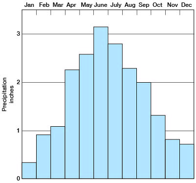
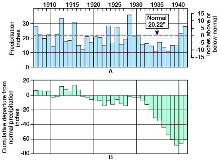
The mean annual precipitation at Garden City is 20.22 inches and at Cimarron it is 21.43 inches. Deviations from the mean, however, are frequent. At Garden City the recorded annual precipitation has ranged from a minimum of 8.87 inches in 1937 to a maximum of 34.81 inches in 1923; at Cimarron the recorded annual precipitation has ranged from a minimum of 10.68 inches in 1934 to a maximum of 35.33 inches in 1928. A large proportion of the precipitation falls as torrential rains that are separated by long dry periods. About 75 percent of the total annual precipitation falls during the crop-growing season from April through September (fig. 4). The normal rainfall during June, the wettest month, is about 3.15 inches; during January, the driest month, it is only about 0.35 inch.
Figure 4--Normal monthly distribution of rainfall at Garden City.
Precipitation in this area seems to follow more or less irregular cycles in which periods of excessive moisture alternate with periods of deficient moisture or drought. The periods of deficient rainfall generally are of longer duration than those of excessive rainfall. The annual precipitation and the cumulative departure from normal precipitation at Garden City and Cimarron are shown graphically in figures 5 and 6.
Figure 5--Graphs showing (A) the annual precipitation at Garden City, Finney County, Kansas, and (B) the cumulative departure from normal precipitation at Garden City. (From records of U.S. Weather Bureau.)
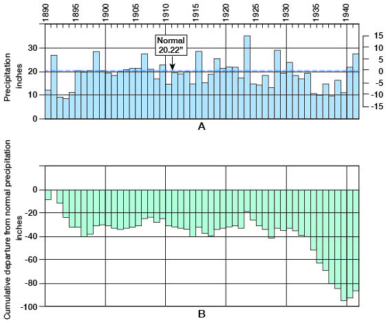
Figure 6--Graphs showing (A) the annual precipitation at Cimarron, Gray County, Kansas, and (B) the cumulative departure from normal precipitation at Cimarron. (From records of U.S. Weather Bureau.)
Prev Page--Introduction || Next Page--Geology
Kansas Geological Survey, Geology
Web version April 2002. Original publication date Dec. 1944.
Comments to webadmin@kgs.ku.edu
The URL for this page is http://www.kgs.ku.edu/General/Geology/Finney/03_geog.html