![]()
Prev Page--Geography || Next Page--Ground Water, Permeability, Artesian
Geology
Summary of Stratigraphy
The rocks that crop out in Finney and Gray counties are all of sedimentary origin and range in age from Upper Cretaceous to Recent. Outcrops of the formations are shown on plate 1. The oldest rocks exposed at the surface in this area are Upper Cretaceous in age and comprise parts of the Greenhorn limestone, Carlile shale, and the Niobrara formation. Tertiary deposits of silt, sand, and gravel (Ogallala formation), which overlie the Cretaceous beds over most of Finney and Gray counties, are exposed only along parts of the Arkansas valley, along the Pawnee valley, and on the uplands north of the Pawnee valley. Clay (the Laverne (?) formation and/or the Woodhouse (?) clays of Elms) occurs locally above the Cretaceous beds in northwestern and southern Finney County and in northwestern Gray County.
Undifferentiated deposits of clay, silt, sand, and gravel of Pleistocene age, Pleistocene terrace deposits, and Quaternary alluvium and dune sand cover most of the surface in this area.
Information on the unexposed rocks that lie beneath Finney and Gray counties has been obtained from test holes drilled during the course of the investigation, from logs of oil and gas test wells, and from exposures of these rocks in nearby areas. They include shales and sandstones of Cretaceous age that underlie the Greenhorn limestone over all of this area and Paleozoic limestones and shales with lesser amounts of sandstone, gypsum, anhydrite, and salt that are encountered beneath the Cretaceous deposits.
A generalized section of the geologic formations of this area is given in table 3.
Table 3--Generalized section of the geologic formations of Finney and Gray counties, Kansas.
| System | Series | Subdivision | Thickness (feet) | Physical character | Water supply |
|---|---|---|---|---|---|
| Quaternary | Recent and Pleistocene | Alluvium and terrace deposits | 0-68 | Very coarse gravel, sand, and silt comprising stream deposits in the Arkansas Valley, Pawnee valley, and the valleys of other smaller streams. Very coarse gravels occur as terrace deposits along the Arkansas and Pawnee valleys. Terrace gravels occur benea | The alluvium yields large supplies of water to wells in the Arkansas valley and lesser amounts in the other stream valleys; supplies many irrigation and a few industrial wells in the Arkansas valley. Some waters from the alluvium are very hard, containing |
| Unconformable on older formations | |||||
| Dune sand | 0-70 | Fine- to medium-grained wind-blown sand. Covers a large area south of the Arkansas valley and occurs in smaller areas north of the Arkansas valley. | Occurs above the water table; therefore, it yields no water to wells. The dunes, however, serve as important catchment areas for recharge from local precipitation | ||
| Unconformable on older formations | |||||
| Pleistocene | Undifferentiated deposits | 0-300+ | Consolidated and unconsolidated lenses of clay, silt, sand and gravel that are lithologically similar to materials of the Ogallala formation. Contain nodules and beds of caliche and locally volcanic ash. | The sands and gravels of the Ogallala formation and Pleistocene undifferentiated beds are the most important sources of water in Finney and Gray counties. Most of the domestic and stock wells on the uplands, many of the irrigation and industrial wells, an | |
| Unconformable on older formations | |||||
| Tertiary | Pliocene | Ogallala formation | 0-250 | Calcareous silts, sands, and gravels, much of which is cross-bedded. Both consolidated and unconsolidated. Contains nodules and beds of caliche. | |
| Unconformable on older formations | |||||
| Lower Pliocene and Upper Miocene (?) | Laverne (?) formation | 0-91.5 | Tan, brown, and gray silty blocky clay and clay shale, containing some medium-grained sand to fine gravel. Encountered only in test holes 15 and 16 in southern Finney County. | Sands and gravels locally are potential sources of water supply, but they have not been exploited because of their great depth. | |
| Unconformable on older formations | |||||
| Cretaceous | Gulfian* | Smoky Hill chalk member (No rara formation) | 0-225 | Alternating beds of soft chalky shale and chalk containing some thin beds of bentonite. Not exposed in Finney and Gray counties. | Relatively impermeable. Not known to yield water to wells in Finney and Gray counties. |
| Fort Hays limestone member (No rara formation) | 55-80 | Thick massive beds of chalk and chalky limestone separated by thin beds of chalky shale. Exposed over wide area in northeastern Finney County. | Supplies limited amount of water to few wells and springs in Finney County. Water occurs in fractures and solution openings. Not an important water-bearer. | ||
| Codell sandstone member (Carlile shale) | 260 +/- | Dark gray to black noncalcareous sandy shale and shaly sandstone. Encountered in test holes 1, 3, and 4. | Two wells (1 and 8) obtain meager supplies of water from the Codell in Finney County. In most places adequate supplies of water may be obtained from higher formations. | ||
| Blue hill shale member (Carlile shale) | Dark gray, bluish-black, and black noncalcareous shale containing thin seams of gypsum and in the upper part a zone of septarian concretions. Exposed in wide strip along the Pawnee valley in northeastern Finney County. | Three unused wells (46, 47, and 57) tap the Blue Hill shale member. Because of the low permeability of the material the wells were abandoned. | |||
| Fairport chalky shale member (Carlile shale) | Calcareous shale containing thin beds of chalk or chalky limestone and few thin beds of bentonite. Not exposed in Finney and Gray counties. | Not known to yield water to wells. | |||
| Greenhorn limestone | 130 | Light to dark gray, thin, chalky and crystalline limestones separated by thicker beds of light to dark gray chalky shale that contain thin beds of bentonite. Exposed in small area in southeastern Gray County. | Reported to yield small supplies of water to wells in southeastern Gray County. | ||
| Graneros shale | 50 +/- | Gray noncalcareous shale containing interbedded lenses of sandstone and sandy shale. Not exposed in Finney and Gray counties. | Relatively impermeable. Not known to yield water to wells. | ||
| Dakota formation | 50-200 (?) | Light gray, tan, buff, red, and brown fine- to medium-grained sandstone and light gray, yellow-tan, and brown shale, sandy shale, and clay. Not exposed in Finney and Gray Counties. | Sandstones yield moderate supplies of soft water to a few wells in southeastern Gray County. | ||
| ?? | |||||
| Comanchean* | Kiowa (?) shale | 44-100+ | Gray, bluish-black, black, and yellowish-gray shale containing a few thin beds of gray limestone and sandstone. Not exposed in Finney and Gray counties. | Relatively impermeable. Not known to yield water to wells in Finney and Gray counties. | |
| Cheyenne (?) sandstone | 70 +/- | Cross-bedded, fine- to coarse-grained, light gray to yellow quartz sandstone, containing interbedded gray to black silty and sandy shale. Not exposed in Finney and Gray counties. | Not known to yield water to wells in Finney and Gray counties. | ||
| Unconformity | |||||
| * Classification of the State Geological Survey of Kansas. | |||||
Geologic History
Paleozoic Era
Very little is known about the conditions that existed in this area during the Paleozoic era. Logs (logs 58-60) of several oil and gas wells, however, indicate that the area is underlain by nearly 6,000 feet or sediments deposited during this era, and that all of the Paleozoic systems are represented except possibly the Silurian and Devonian.
Thick limestones and dolomites, some shale, and very little sandstone were deposited prior to the Permian period. The area was Probably covered by moderately deep seas during most of the Paleozoic era. Thick limestones, such as are found in the deep oil and gas test wells, were deposited in these seas. The land, however, was not covered by the sea continuously, for records indicate that deposition in the seas was interrupted from time to time by erosion. A great variety of sediments was deposited during the Permian period, consisting chiefly of red shale, sandstone, and sandy shale but containing also beds of salt, gypsum, anhydrite, and limestone. Alternating submergence and emergence of the land probably continued into the early part of the Permian period, but during the latter part of the period there was a widespread emergence that produced shallow basins and low plains. The great mass of red clay and sand that forms the upper part of the system in this area probably was laid down on this type of topography. The coarser materials were deposited by streams; the finer materials probably were deposited in shallow basins or bayous and on wide mud flats. The climate seems to have been somewhat more arid than it is now, for the deposition of sand and clay was interrupted at different times by the chemical precipitation of salt and gypsum, which are products of evaporation in shallow bodies of water. Continential deposition was predominant during the latter part of the Permian period, and by the close of the period the shallow seas had withdrawn completely. The streams that had been depositing sediments began to erode the land surface. This summary of Permian history is based largely on a report by Darton (1920, p. 7).
Mesozoic Era
Triassic and Jurassic periods--The Triassic and Jurassic periods are not represented by rocks in this area. During these periods the Permian rocks were subjected to erosion as a result of an uplift of the Paleozoic rocks which occurred early in the Mesozoic era. It is possible, however, that there was some deposition during the early part of the Mesozoic era but that later erosion completely removed the sediments prior to Cretaceous sedimentation.
Cretaceous period--The oldest Cretaceous sediments found in the area consist predominantly of quartz sand (Cheyenne (?) sand stone) and, according to Twenhofel (1924, p. 19), represent either shallow-water marine or stream deposition. Following the deposition of sand, the land was submerged and covered by a moderately deep sea in which was deposited the dark clay that in part comprises the Kiowa (?) shale. Thin sandstones and shell-limestone interbedded in the shale were deposited during minor fluctuations of sea level. A recurrence of conditions similar to those that existed when the Cheyenne was deposited occurred in later Cretaceous time; that is, the sea retreated and continental deposits of sand and clay, represented by the Dakota formation, were laid down. The sandy surface of the Dakota was then covered by the sea and the deposition of the dark clay and sand that forms the Graneros shale began.
During the remainder of Cretaceous time or at least until the close of Niobrara time, the land was covered almost continuously by shallow to moderately deep seas. Following the deposition of the Graneros shale the alternating beds of clay and limestone that form the Greenhorn limestone were deposited. Following this nearly 400 feet of clay which now forms the Carlile shale was deposited. The lower clays of the Carlile are calcareous (Fairport chalky shale member), but the upper clays are nearly barren of any calcareous matter (Blue Hill shale member). During a short interval toward the close of the time when the Carlile was deposited, the sea probably retreated somewhat and sand and sandy clay were deposited in some areas (Codell sandstone member). This was followed by an abrupt change to moderately deep-sea conditions when several hundred feet of calcareous sediments (Niobrara formation) were deposited. Thin beds of bentonite in the Greenhorn limestone, Carlile shale, and Niobrara formation indicate that at different times volcanic ash was blown into the seas in which these sediments were being deposited. The ash upon settling was deposited as thin beds in the clays of these formations and subsequently was altered to bentonite.
No Cretaceous sediments later than the Niobrara formation are now found in this area, although they might very possibly have been deposited and subsequently removed by erosion. In the late Cretaceous or early Tertiary period the strata in western Kansas were tilted, for at the present time they dip gently toward the northeast.
Cenozoic Era
Tertiary period--During the early part of the Tertiary period the strata in the northern part of the area were gently folded, resulting in a synclinal trough which trends north and south. This trough extends from the Arkansas valley in western Finney County northward into Scott County. In this area it is known as the Finney basin (Smith, 1940, p. 138) and it is continuous with the Scott basin in Scott County (Waite, in press).
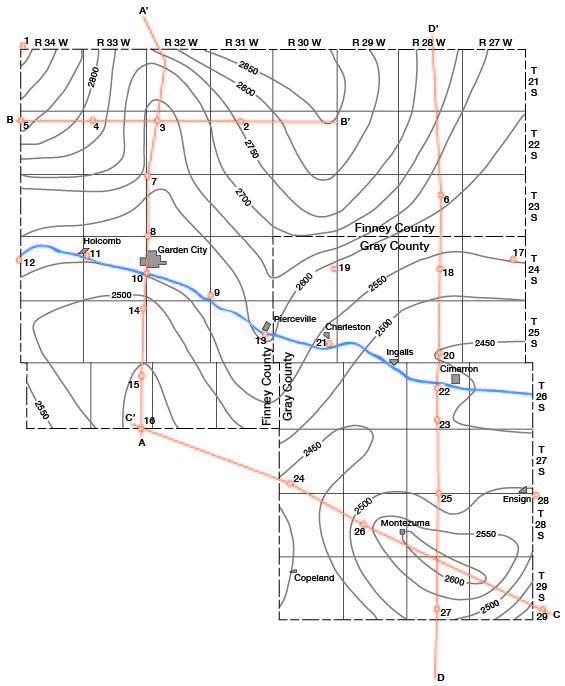
At about the same time a long period of erosion was begun. During this period of erosion hundreds of feet of Cretaceous sediments were stripped off. In the southern part of the area all of the Cretaceous strata down to and including part of the Dakota formation were eroded away. During this same period of erosion the trough in northern Finney County was deepened appreciably, exposing the Carlile shale on the western flank. The present shape of the Finney basin in cross section is shown by section B-B' in figure 8, and the areal shape is indicated in figure 7 by contour lines drawn on the pre-Tertiary surface.
Figure 7 indicates the existence of at least two valleys in this area prior to the deposition of Ogallala sediments. One probably drained from north to south through the western part of Finney County following the structural trough mentioned above. The other valley seemingly entered the area at a point east of Cimarron and drained southwestward through central Gray County. The two valleys probably met in northern Haskell County and joined a through-flowing master stream somewhere farther south.
Figure 7--Map of Finney and Gray counties showing by means of contours (dashed lines) the shape and slope of the pre-Tertiary surface, location of test holes (numbered circles), and location of cross sections shown in figure 8 and figure 9.
The oldest Tertiary deposits that were laid down in this area are of late Miocene (?) and early Pliocene age. These deposits, which consist chiefly of clay and comprise the Laverne (?) formation, probably were laid down in lakes and on the flood plains of streams. A period of stream erosion followed the deposition of these clays. A reversal of conditions from stream erosion to stream deposition occurred during the Pliocene epoch. Widely shifting streams deposited rock debris from the mountains to the west over the entire High Plains surface. These deposits, consisting of clay, silt, sand, and gravel, make up the Ogallala formation. The surface upon which these sediments were deposited was very irregular and had much more relief than the present land surface (see figs. 7, 8 and 9). By the close of Ogallala time both the valley areas, including the trough in northern Finney County, and the high areas had been buried beneath these sediments, resulting in a nearly flat eastward-sloping surface. The deposition of the Ogallala sediments closed the Tertiary period of deposition.
Quaternary period--During very late Pliocene or early Pleistocene time there was renewed downwarping in northern Finney County that again produced a basin over the pre-Ogallala trough. The large lowland area south of Arkansas River in southern Finney County, which is now covered by sand hills, was produced by subsidence that probably was contemporaneous with the downwarping in northern Finney County. The downwarping and subsidence in this area probably occurred contemporaneously with faulting and folding in other parts of western Kansas. Faulting took place in the Meade basin in Meade County during late Pliocene or early Pleistocene time (Frye, 1942, p. 26) and, according to McLaughlin 1943, p. 36), strata in southern Hamilton and Kearny counties Were faulted at about the same time.
A short period of erosion probably followed or was contemporaneous with the crustal movements that took place in western Kansas. This period or erosion, however, was less severe than the erosion that preceded the deposition of the Ogallala formation, for the resulting surface had slight relief compared with the pre-Ogallala surface.
During Pleistocene time water-laid sediments of clay, silt, sand, and gravel were deposited. These deposits completely filled the Finney basin and the lowland area south of Arkansas River and spread out over the entire surface of this and adjoining areas. These sediments make up the larger part of the undifferentiated Pleistocene deposits described on pages 171-177, and are equivalent to the Meade formation and part of the Kingsdown silt of the Meade basin. Following the deposition of the Pleistocene beds there must have been renewed downwarping or areal subsidence in the Finney basin and in the area now occupied by the sand hills, for at the present time these two areas are topographically much lower than the surrounding uplands. It is hard to conceive of these areas as being products of stream erosion alone. Smith (1940, p. 138) makes the following statements concerning the Finney basin:
It has no surface drainage outlets, displays no evidence whatever of ancient stream channels, and is dotted with innumerable minor depressions and undrained basins, some of which are almost a mile in length. It obviously cannot be explained as a product of stream erosion, and consequently can be attributed only to post-Ogallala downwarping.
The low area now occupied by sand hills, however, probably is the result of both areal subsidence and stream erosion. Thick Pleistocene terrace gravels beneath the sand hills south of the present Arkansas River indicate that the course of the ancestral Arkansas River during the late Pleistocene time was far south of its present course. At one time it probably flowed within a few miles of the southern edge of the present sand hills. As a result of subsidence, the river migrated gradually northward until it reached its present position. As the river migrated northward it left thick deposits of coarse sand and gravel that now form the terraces along the south side of the valley. Although erosion was the dominant factor in the history of this area from late Pleistocene time to the present, sedimentation was not entirely absent. Wind-blown sand has accumulated to form the dunes or sand hills in the broad lowland belt south of the Arkansas valley and in some localities in the Finney basin and on the uplands north of the valley. At about the same time a thin mantle of eolian loess, consisting mostly of silt and clay, was deposited on the upland areas of the two counties. The loess is equivalent to the uppermost part of the Kingsdown silt (Pleistocene and Recent) of Meade County. The most recent sedimentation has taken place in the valleys where alluvial silt, sand, and gravel have been deposited in the channels and on the flood plains of the streams.
In northeastern Finney County, Pawnee River and its tributaries have eroded valleys deep enough to expose the Fort Hays limestone member of the Niobrara formation and the Carlile shale; in southern Gray County erosion by a tributary of Crooked Creek has exposed the Greenhorn limestone (fig. 9). These streams and their tributaries are still eroding their valleys at the present time. Arkansas River has not been able to cut below the Ogallala formation in this area, however, and there is some evidence that within historic time the river actually has been depositing rather than eroding (Smith, 1940, pp. 173, 174).
During Recent time many shallow depressions have developed on the surface in this and surrounding areas. Although they occur nearly everywhere on the upland surface, they are especially numerous in the Finney-Scott basin. The origin of the depressions is not known with certainty, but they are thought to be the result of subsidence due to solution in underlying beds. Smith (1940, p. 171) suggests that they are due to the solution of calcareous beds in the Cretaceous rocks, or, in some areas, to the solution of salt or gypsum in Permian or early Mesozoic formations. This theory seems to explain satisfactorily the origin of large sinks such as the "Salt well" in Meade County and Big Basin and St. Jacob's well in western Clark County, but it is difficult to understand how the many small depressions dotting the uplands could have originated as a result of solution in deep-lying beds. The theory proposed by Johnson (1901 pp. 703, 704) seems to account more plausibly for the origin of these small, shallow depressions. He states that:
"Appearances indicate basining of the alluvial surface as a consequence, first, of rain water accumulation in initial faint unevennesses of the plain; second, of percolation of this ponded surface water downward to the ground water in largely increased amount from these small areas of concentration, rather than from the whole surface uniformly, with the result that the alluvial mass is appreciably settled beneath the basins only. ... This settlement takes place as the combined effect of mechanical compacting of the ground particles and chemical solution of the more soluble particles.
Prev Page--Geography || Next Page--Ground Water, Permeability, Artesian
Kansas Geological Survey, Geology
Web version April 2002. Original publication date Dec. 1944.
Comments to webadmin@kgs.ku.edu
The URL for this page is http://www.kgs.ku.edu/General/Geology/Finney/04_geol.html