![]()
Prev Page--Synopsis of continental rifts || Next Page--Review of wireline-log responses
Appendix 2. Geology of Midcontinent Rift System (MRS)
The Midcontinent Rift System (MRS; Wold and Hinze, 1982) is recognized by a significant elongate magnetic and gravity anomaly extending northeastward from south-central Kansas into the Lake Superior region and hence southeastward into the Michigan basin (Figure 45). Van Schmus and Hinze (1985) and Dickas (1984, 1986) provide excellent overviews of the Midcontinent Rift System. A characteristic suite of bimodal volcanics, plutonic rocks, and clastic rocks ranging in age from 1.0 to 1.2 billion years (Middle Proterozoic era, Keweenawan Supergroup) comprise the rift proper. Additional younger clastic rocks were deposited after the main rifting phase, deposited in crustal depressions [sag basins] (Morey and Green, 1982). This succession has been found throughout the rift system described to date. Considerable data have been obtained in the outcrops around Lake Superior and from several boreholes. The Poersch well was the first deep-test along the southern leg of the MRS and provides an opportunity to compare the two parts of the rift systems.
Figure 45--Generalized geologic map showing major features of the prerift Pracambrian basement and principal geologic units associated with the Midcontinent Rift System. Random "=" Represent central rift igneous rocks and associated sedimentary rocks, including Oronto Group; stippled pattern represents late upper keweenawan clastic rocks of the post-tectonic phase (Bayfield Group, Jacobsville Sandstone, etc.) in basins flanking the main rift sequence; horizontal-ruled pattern represents rift basin fill whose character is unknown in detail in the eastern region; dots north and northeast of Lake Superior represent alkaline complexes (from Van Schmus and Hinze, 1985).
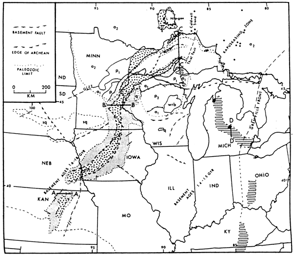
Alkaline and carbonatite complexes of approximately the same age as the MRS (1,000-1,200 Ma) and with similar reversed and normal magnetic polarities common to the basalt flows occur in the Lake Superior region. Many other gravity and magnetic anomalies occur along the rift that may represent other alkaline plutons such as those penetrated in Iowa and Nebraska near the MRS. Reliable dates are not available on these plutons according to Van Schmus and Hinze (1985).
The Grenville Province is an igneous and metamorphic belt in the eastern United States that was active from 1,150 to 900 Ma. It is thought to represent a collision of tectonic plates including the Precambrian shield in which the MRS is situated. Activity along the Grenville Front peaked during two episodes, 1100±50 Ma and 950±50 Ma. Van Schmus and Hinze (1985) believe that the Keweenawan rifting and the Grenville event are possibly genetically related. The rapid changes in magnetic polarity during main rifting of the MRS suggest that tectonic plates were actively moving or undergoing significant changes in direction, possibly inducing tensional forces that may have lead to rifting along the MRS (Halls and Pesonen, 1982).
Structure of the rift
Faulting is characteristic of rifts. Surface exposures in the Lake Superior area reveal details of the faults in this region. Surface expressions of the faults indicate predominantly high-angle reverse movement in the Lake Superior basin and parallel to the axis of the structure. There are no major normal faults visible at the surface. The reverse faulting is interpreted to be derived from post-rift deformation, but before Cambrian deposition in the area. Reverse faulting contributed to horst development where the central volcanic complex became juxtaposed against younger flanking clastic sedimentary rocks. McSwiggen et al. (1987) interpret some of these reverse faults as reactivated basin-controlling normal faults that were initially associated with extensional tectonics (Figure 49A).
The younger sediments thicken from the edges of the rift toward the volcanic pile before they are truncated. They also cover portions of the volcanics. The younger sedimentary units were deposited in a broader basin extending beyond the rift proper (sag-basin deposits). Transverse faults, perpendicular to the axis of the rift in the Lake Superior basin cut older marginal faults. It has been debated whether any strike-slip faulting is noted. Faulting appears to post-date folding observed in these exposures. The folds are believed to be pene- and post-contemporaneous with basin formation (Davidson, 1982).
The interpretations of geophysical data have provided the bulk of the structural interpretations. There is considerable disagreement about the nature of the structures along the northern end of the MRS (McSwiggen et al., 1987), including fundamental questions such as the existence of normal faults. The COCORP surveys, e.g., Serpa et al. (1984), indicate that the late high-angle reverse faulting is not a universal feature of the MRS and may be significant only in the western Lake Superior region and northern NFRS (Van Schmus and Hinze, 1985).
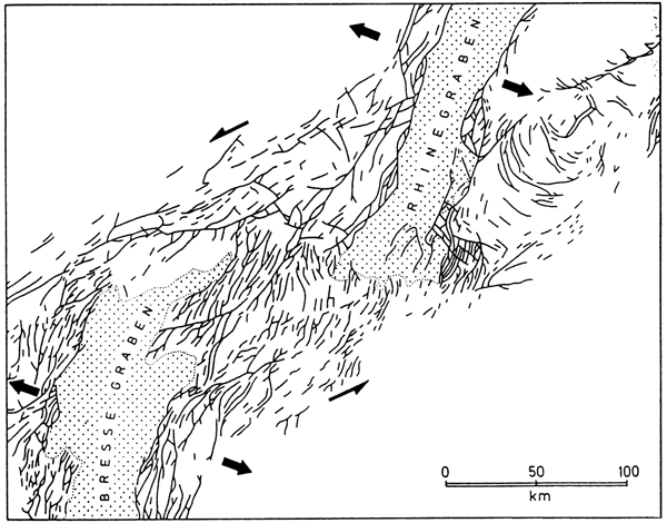
Less controversial is evidence for the disruption along the course of the MRS. An offset in southern Minnesota swings the MRS to southeast and back. The gravity map indicates that the gravity high is continuous, albeit narrower in this area. The Nebraska offset is a discontinuity in the gravity expression and indicates later faulting or jump of the rift to a pre-existing structural discontinuity (Van Schmus and Hinze, 1985). Transverse or transform faults have also been attributed as the cause of these offsets (King and Zietz, 1971). Information is stiff not definitive whether the discontinuities predate or post-date the MRS (Van Schmus and Hinze, 1985). Illies (1981) describes an offset characterized by a pattern of en echelon faults along the Rhinegraben and Bresse graben which he relates to differential rates of crustal spreading along the rift and pre-existent crustal anisotropy (Figure 46). This may be an analog to some of the offsets noted along the MRS.
Figure 46--En echelon faults along Rhinegraben and Bresse graben, Germany. Arrows show sense of movement (from Illies, 1981).
McSwiggen et al. (1987) applied the detachment-surface rift model developed for the Gregory rift of East Africa by Bosworth (1987) to the Midcontinent Rift System in eastern Minnesota and western Wisconsin. As summarized by McSwiggen et al. (1987), the northern sector of the MRS contains a central zone of mostly volcanics and associated intrusive rocks extending 10-20 km (6-12 mi) deep with flanking and, in cases, overlying clastic sedimentary basins ranging in thickness from 1.5 km to 3 km (1-1.8 mi). The geometry of the central igneous zone changes from symmetric on the north to asymmetric on the south. The central igneous zone is interpreted by them as volcanic flows and intrusives, which filled a series of fault-bounded grabens (McSwiggen, et al.; Figures 47, 48, and 49). On the south an asymmetric half-graben geometry prevails, based on interpretation of COCORP seismic line (Serpa et al., 1984). It is inferred from their diagram that there is reverse movement on faults that were originally normal faults. The structural reversal resulted in horst development of the volcanics pile at the center of the rift system. It is inferred through their gravity and magnetic modeling that the process of extension on the north was similar in form to that in the south (e.g., Kansas), in contrast to some earlier interpretations.
Figure 47--Bouguer gravity (A) and magnetic anomaly map (B) of parts of northern Midcontinent Rift System. Index map of four profiles along rift system shown in figures 48 and 49 (from McSwiggen, et al., 1987).

Figure 48--Gravity and magnetic profiles and corresponding geologic models from McSwiggen et al., 1987. Figure 47 indicates location of profiles. A larger PDF version is available.
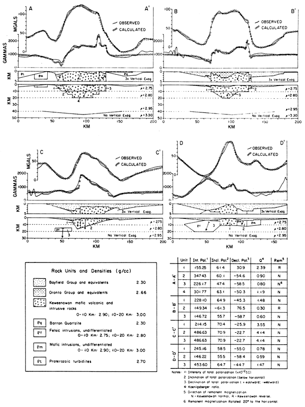
Figure 49--Geologic interpretation along four profiles across Midcontinent Rift. Section C after Sims and Zietz (1967) and D after Serpa et al. (1984).

McSwiggen et al. (1987) suggest that the volcanic igneous rocks were significantly less common along the southern MRS than in the Lake Superior area due to younger development and less extensive rifting in the south. This is supported by estimates of extension ranging from at least 60 km of extension for the northern MRS (Chandler, 1983) and 29 km of extension along the southern rift along the COCORP line in Kansas (Serpa et al., 1984). The sedimentary rocks that dominate the lower portion of the Poersch well are generally consistent with the seismic interpretation of Serpa et al. (1984). Mafic igneous extrusives and intrusives dominate the upper 1,400 m (4,600 ft) of the Precambrian in the Poersch wen. This does not appear to affect the interpretation of McSwiggen et al. (1987), but rather supports it.
McSwiggen et al. (1987) suggest that the southern rift in Kansas is analogous to an arrested stage of development along the Gregory rift of the East African Rift System described by Bosworth (1987). The Kansas portion of the MRS apparently did not develop as extensive a conduit system for extrusion of volcanic material. Furthermore, the Poersch well indicates that most magma was emplaced as extrusives rather than significant intrusives. The diminished igneous activity along the southern portion of the rift might have been a function of the amount of heat focused on the lower crust (McSwiggen et al., 1987).
Lee and Kerr (1984) also used the East African Rift System as an analogue for the MRS. They interpret a "rift pillow" within the lower lithosphere based on seismic and gravity data. The pillow is analogous to the attenuated lithosphere beneath the rifted lithosphere in Bosworth's model (Figure 39) and contains both components of lithosphere and asthenospheric material created by a necking or attenuation of the crust as it responded in a ductile manner. Attenuation is supported by 10-km (6-mi) thinning noted by Steeples and Miller (1988), a low-velocity core in the upper mantle by Hahn (1980), high seismic velocity at mid-crustal levels beneath MRS (Lui, 1979), deep igneous root of Ocala and Meyer (1973), and a gravity high caused by dense material beneath 10 km (6 mi) proposed by Serpa et al. (1984). These data suggest upper-mantle and asthenospheric material now occupy a position in the lower lithosphere along the MRS. The rift pillow (upwelled asthenosphere) would feed the extrusive phase of rifting. Following extension and rifting, thermal decay of the upwelled asthenosphere would produce a broad sag basin according to general rift models including that proposed by Lee and Kerr (1984). Lee and Kerr (1984) suggest that this sag basin is filled with Proterozoic and early Cambrian sedimentary rocks. According to a general rift model, these latter deposits would be characterized by minimal deformation compared to synrift deposits.
Tectono-stratigraphy
Three tectono-sedimentary sequences comprise the MRS: the synrift, post-volcanic, and sag-basin deposits (Van Schmus and Hinze, 1985). The synrift sedimentary rocks are described in greatest detail from the Lake Superior area where synrift deposits are dominated by mafic volcanics (Table 5). Strata deposited preceding rifting and volcanic activity in the Lake Superior area are mature quartzose sandstones indicating stable cratonic conditions. Volcanism in this region began during very early stages of rifting suggesting some kind of initial thermal perturbation. Consequently, sediments interbedded with the volcanic rocks in this northern region are somewhat limited in extent (Morey and Jirsa, 1980).
Table 5--Stratigraphic summary for MRS for the Lake Superior Region: (A) from Dickas (1984) and (B) from Van Schmus and Hinze (1985).
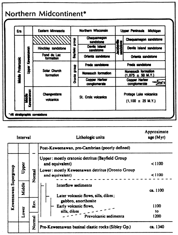
Synrift sedimentary rocks are controlled by the rift-basin architecture. Along the northern MRS these sedimentary rocks are typically coarse, immature, polymictic, red-bed terrigenous clastics (Ojakangas and Morey, 1982). The post-volcanic rift-basin units also show a close association with the main rift tectonic activity (Van Schmus and Hinze, 1985). In the Lake Superior areas these sediments are mostly clastic debris derived from volcanic rocks. The sediments along the northern MRS mark the beginning of the Late Keweenawan (Morey and Green, 1982). They include the Copper Harbor Conglomerate, Nonesuch Shale, and Freda Sandstone of the Oronto Group in Wisconsin and Michigan and the equivalent Solar Church Formation in Minnesota (Table 5). The Copper Harbor was deposited under alluvial conditions in depressions along the rift contemporaneous with and following Late Keweenawan volcanism. The Nonesuch Shale was deposited in a lacustrine environment that flanked the rift system. The lower portion of this conglomerate is locally interbedded with the Copper Harbor conglomerate. The Freda Sandstone overlies the preceding units and marks a transition into fluvial sedimentation that is more characteristic of the stable craton.
The Copper Harbor Conglomerate is 600 to 6,000 ft (180-1,800 m) thick and contains conglomerates, conglomeratic sandstones, trough cross- stratified sandstone, and rippled sandstone (Elmore, 1984). The conglomerate is typically well rounded and poorly sorted with cobble to boulder clasts. Rhyolite fragments are the dominant clast qW. Sandstones are volcanic arenites and sublitharenites. They contain aphanitic rock fragments, calcium plagioclase, quartz, and other labile minerals. The trough-cross stratified sandstone facies has 15-30-ft (4.5-9-m)-thick cycles of conglomerate to pebbly sandstone. Abundant desiccation features suggest some aeolian contribution or at least subaerial exposure. This is characteristic of ephemeral streams. The fine- to medium-grained rippled sandstone is also horizontally laminated with ubiquitous mud drapes, mud intraclasts, and mud cracks and are thought to represent waning sheet floods on alluvial fans (Elmore, 1984). Elmore also describes the occurrence of cryptalgal carbonates with oolites, intraclasts, and calcite pseudomorphs after gypsum. These are additional evidence for alternating dry and shallow-water conditions.
The Nonesuch Shale overlies the Copper Harbor Conglomerate along the northern MRS. Potassium-argon dates for this shale indicate an age of 1023±46 Ma. Interpretations by Elmore (1984) include basinward thickening, fining-upward wedges of strata deposited proximal to distal braided streams, and short flood facies on coalesced alluvial fans and sand flats. The general fining-upward sequence from the Copper Harbor Conglomerate to the Nonesuch Shale is related to diminishing sediment supply following a lowering of source area (Elmore, 1984).
Lee and Kerr (1984) describe the favorable petroleum source-rock potential of this shale in northern Michigan. The shale is noted for its oil seeps in the White Pine Mine upper mine (Kelly and Nishioka, 1985). In this area the Nonesuch Shale is a thinly laminated, gray siltstone and organic-rich black shale inter-stratified with red and brown coarser strata. It averages 600 ft (180 m) thick (Dickas, 1984). It is interpreted to have been deposited in a deep anoxic lake within the graben system (Lee and Kerr, 1984).
Morey and Jirsa (1980) describe another post-volcanic red-bed deposit that is interpreted to have been laid down late in the history of the rift. The detritus is derived from outside of the rift system, notably quartz, potassium feldspar, sodium plagioclase, and granitic rock fragments. Morey and Jirsa (1980) describe its depositional setting in half-graben basins along the flanks of the rift.
The youngest deposits associated with the rifting event are sag-basin deposits that fill broad basins created by thermal contraction. Sediments can be derived from the rift itself (volcanic sources) and sediments from the older Precambrian craton (Van Schmus and Hinze, 1985). These deposits include the Bayfield Group of Wisconsin, the Fond du Lac Formation and Hinckley Sandstone in Minnesota, and the Jacobsville Sandstone in the eastern Lake Superior region. The Rice Formation of Kansas is thought to be equivalent lithologically and in an analogous structural relationship to these strata (Van Schmus and Hinze, 1985). The sequence of red clastics in a deep drill hole in the Michigan basin over the geophysical anomaly is also placed in this group (Fowler and Kuenzi, 1978). Thicknesses of these strata approach 2-4 km (3-6 mi) and have a much broader distribution than earlier synrift deposits. Slopes were gentler and faulting was minimal. Volcanics would not be expected to be significant components in these sediments.
The Rice Formation occurs at the surface of the Precambrian in two rather extensive areas in Kansas referred to as the "western basin" or the Rice basin extending from Reno County to Washington County and a paralleling basin to the east (Figure 42). These basins are separated by a north-northeast trend of mafic igneous rocks that follows the axis of the Midcontinent geophysical anomaly (Scott, 1966). The Poersch well was drilled in the eastern flank of the geophysical anomaly.
The Rice Formation consists of dark-reddish-brown, fine-grained feldspathic sandstone, arkose, and red and green sandy micaceous shale . Grains are rounded to subangular and frosted. The feldspathic sandstone is commonly conglomeratic. Accessory grains include schist, quartzite, feldsite, granitic granules, and pebbles. Cement is commonly dolomitic such as in the Bishop #15 Reese in sec. 22, T. 19 S., R. 9 W., Rice County. The Rice Formation contains limestone and dolomite interbedded with the sandstones and shale, suggesting marine or lacustrine influences (Scott, 1966).
Prev Page--Synopsis of continental rifts || Next Page--Review of wireline-log responses
Kansas Geological Survey, Texaco Poersch #1 Report
Placed on web March 5, 2010; originally published June 1988.
Comments to webadmin@kgs.ku.edu
The URL for this page is http://www.kgs.ku.edu/Publications/OFR/1988/OFR88_22/10_app2.html