![]()
Prev Page--Contents || Next Page--Geophysical Modeling
1. Introduction
A. Continental rifts
Rifts cover less than 2% of the surface area of the continents, but they may become increasingly important in future petroleum exploration (Rosendahl, 1987). The Midcontinent Rift System (MRS) is an areally extensive rift basin characterized by extensive intrusive and extrusive volcanism followed by and/or interspersed with immature clastic sedimentation. The horizontal extent of the MRS is easily noted by central gravity and magnetic highs flanked by magnetic and gravity lows. Its vertical extent can be determined by seismic reflection. The nominal age of the MRS is 1, 100 million years (Ma), although there was undoubtedly important geologic and tectonic activity in the 500 or more Ma preceding deposition of earliest Paleozoic sediments in the Midcontinent.
There are many continental rifts of various ages in the world and they vary with regional geology and tectonic setting. The more obvious factors in rift development include:
- Volcanics range from sparse to abundant. Magmas are typically bimodal in composition.
- Cratonic rifts are commonly associated with domal uplifts.
- The ratio of length to width is highly variable.
- Rift systems commonly have several episodes of rifting and volcanism.
- Crustal and lithospheric thickness commonly decrease beneath rifts.
- Alkalinity of rift volcanism usually decreases with time.
- Volcanic rocks from continental rift systems commonly reflect undepleted or enriched mantle sources.
- Rifting often occurs along preexisting lithospheric weaknesses in response to changing regional stress or to instabilities in the mantle beneath the rift.
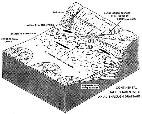
Typical rifts have cross sectional shapes similar to that depicted on the cover of this report. Figure 1 illustrates continental sedimentation associated with a rift having interior drainage. Figure 2 depicts continental sedimentation associated with axial-through drainage. The MRS has most of the typical features shown in these figures and those fisted above. For a more detailed discussion of rifting, the reader is referred to Appendix 1 at the back of this report.
Figure 1--Block diagram depicting sedimentological features of a continental basin with interior drainage developed in a half graben (from Leeder and Gawthorpe, 1987).
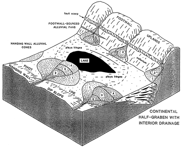
Figure 2--Block diagram illustrating continental half graben with axial through-going drainage (from Leeder and Gawthorpe, 1987).
B. Regional Precambrian geological, tectonic, and geophysical setting
The Midcontinent Rift System (MRS) is an 1,100 Ma feature that extends from Lake Superior to at least south-central Kansas (Halls, 1978; Van Schmus and Hinze, 1985; Yarger, 1982). There is good evidence that it extends in a southeastward direction from Lake Superior beneath the Michigan basin and southwestward into the Anadarko basin in Oklahoma. Throughout its length, it is characterized by a central gravity and magnetic high that is flanked by gravity and magnetic lows. On the gravity and magnetic maps of North America, the MRS is one of the most prominent features by any measure. The feature also is known by other names such as the Midcontinent Gravity High, the Midcontinent Geophysical Anomaly, the Central North American Rift System, and others.
Knowledge of the MRS is based on outcrop information from the Lake Superior area, limited borehole samples where the rift is buried beneath Paleozoic sediments, and much geophysical modeling and extrapolation in between. The rift stands out in contrast to other continental rifts by its great volume of volcanic rocks and by its length (Burke et al., 1978). The thickness of volcanic rocks within the rift is generally interpreted from geophysical data to be from 10 km (6 mi) to 20 km (12 mi; Chandler et al., 1988; McSwiggen et al., 1987). Recent seismic-reflection profiles in eastern Lake Superior indicate that volcanic rocks can be traced to depths of 30 km (18 mi), almost to the base of the crust (Behrendt et al., 1988). The seismic profiles also reveal the existence of a suite of well-preserved clastic sedimentary rocks that overlie the volcanics to a depth of about 10 km (6 mi). The sedimentary sequence provides a record of cratonic depositional history from the end of Keweenawan volcanism through late Proterozoic time.
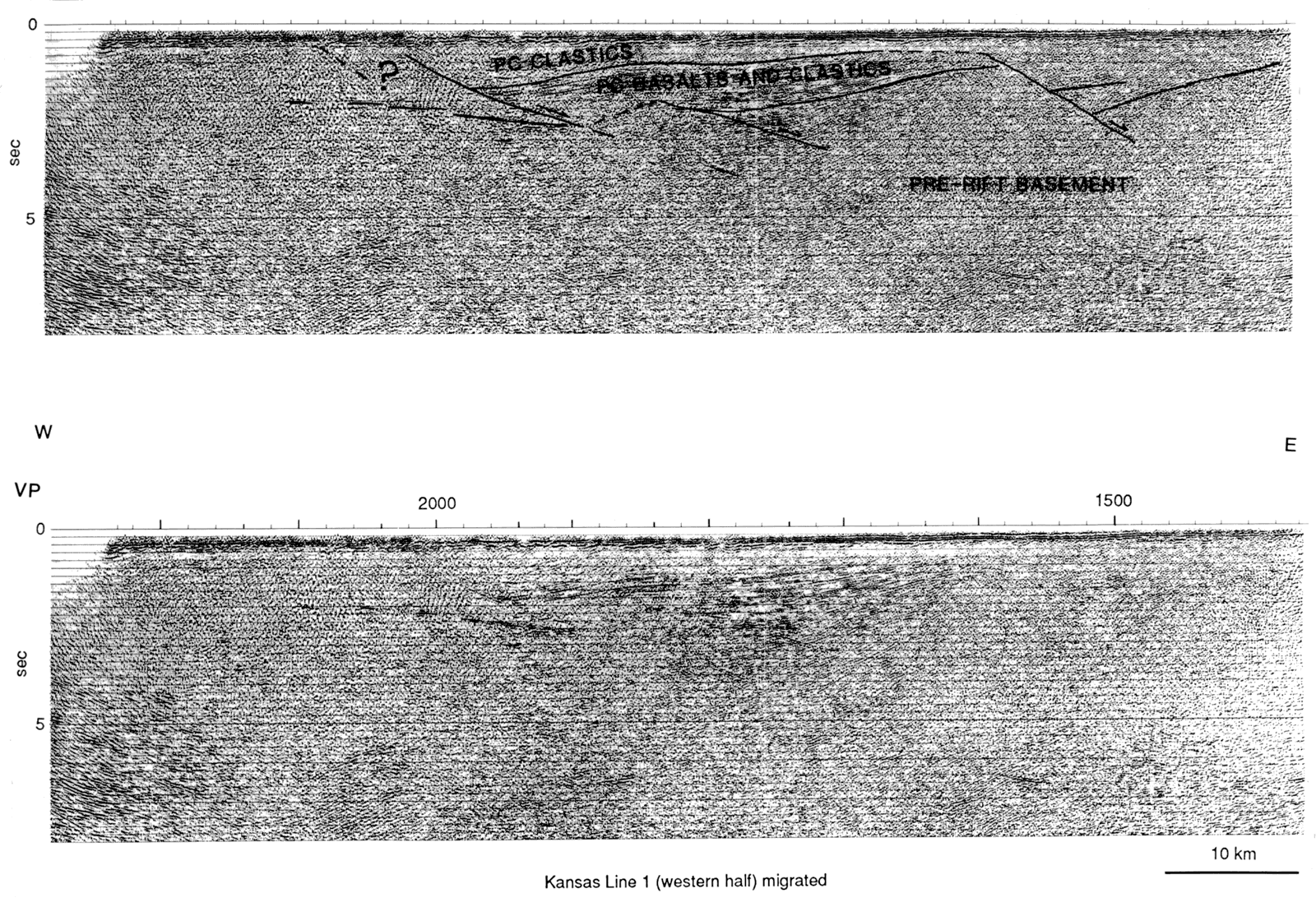
Seismic studies in Kansas have revealed information about the crust and about the rift in the vicinity of the Texaco, 1-31 Noel Poersch. Steeples and Miller (1988) showed that the crust thins by nearly 10 km (6 mi) near the MRS in Kansas relative to normal crust in the Midcontinent. In fact, the Moho dips westward at about 1° from Cloud County toward east-central Colorado. Hahn (1980) showed that the MRS overlies a low-velocity anomaly located in the upper mantle in north-central Kansas. Lui (1979) showed that unusually high velocities are present at midcrustal depths beneath the MRS in north-central Kansas. Somanas et al. (1988) have reprocessed some of the COCORP data at the Kansas Geological Survey, and they interpreted some intrusive activity on the seismic lines. The interpretation is supported by modeling of the magnetic and gravity data.
Serpa et al. (1984) showed data from the COCORP line (Figure 3), establishing a structural high that was drilled by Texaco (the #1 Poersch, the primary subject of this report). Proprietary seismic-reflection data collected by Texaco reveal that the Poersch #1 is located on a multi-township-sized structure that has closure of several thousand feet. The COCORP data and the gravity and magnetic data need to be reinterpreted in the light of substantial geologic data obtained from the #1 Poersch logs and cuttings. That has not yet been done because of the time constraints in producing this report.
Figure 3--Original processed and interpreted version of Kansas COCORP line, modified from Serpa et al (1984). A larger version of this image is available.
The buried portion of the rift is commonly viewed as consisting of a central horst bounded on either side by high-angle normal or reverse faults showing considerable displacement in certain segments. Basins, whose configurations are generally not well defined, occur on either side and are predominantly filled with epiclastic sediments. Sediments also occur within structurally controlled basins on top of the horsts (Dickas, 1986). Besides the high-angle faults that parallel the rift, a large number of approximately northwest-trending faults crosscut the rift. They have been mapped in the Lake Superior region (Morey and Ojakangas, 1982) and are known to affect the basement in the buried portion of the rift. Some of these comprise major structural or tectonic zones that can be traced for hundreds of miles. They are both geophysically (Arvidson et al., 1984; Sims and Peterman, 1986; Kisvarsanyi, 1984) as well as geologically (Berendsen and Blair, 1986; McCracken, 1971) defined. Many of the northwest-trending faults appear to be dominated by apparent strike-slip movement.
Direct knowledge of the nature of the basement rocks, igneous, metamorphic, and sedimentary, in the buried portion of the rift is limited by the number of drill holes that penetrate the Phanerozoic sediments. They are numbered in the tens rather than hundreds. The central horst is believed to be underlain by mostly intrusive and extrusive mafic rock. Fissure-fed flood basalts and gabbros are common rocks that are spatially associated with the rift, but whether they represent metamorphosed rift sediments or not has not been established. Proterozoic sediments present on the horsts and in the flanking basins consist largely of oxidized arkoses, subarkoses, siltstones or shales, and lesser amounts of conglomerate. The sediments along the rift show certain similarities, partly the result of deposition in similar environments. Direct correlation and recognition of distinct stratigraphic sequences in the buried portion of the rift remains problematic.
Renewed interest into the rift over the last 10 years focused attention not only on the hydrocarbon potential of the sediments, but also on the mineral potential of both igneous and sedimentary rocks. The area as a whole may be regarded as virgin territory, but most of it well within the realm of modern exploration methods. The metallogeny of the rift and surrounding basement rocks was recently reviewed by Sims et al. (1987).
C. Regional Phanerozoic structure and tectonics
Mostly Paleozoic sediments, as young as Pennsylvanian, overlie the Proterozoic igneous and sedimentary rocks of the rift. Total thickness of the sediments varies, but generally is less than about 3,000 ft (900 m). The structural grain of the Precambrian basement influenced to a large extent the structures that later developed in the overlying sediments. Within the North American continent, five Paleozoic orogenic phases can be recognized. Associated tectonism gave rise to reactivation of basement structures, and the overlying sediments were either folded or faulted as a result. Major tectonic events are recognized in the sediments overlying the rift by non-deposition or erosion of certain units. It also influenced sedimentation patterns, by altering environments of deposition. Many of the structures that developed as a result of periodic reactivation became sites for hydrocarbon accumulation. Oil and gas fields in Paleozoic sediments above the rift can be observed to be elongated and aligned parallel to the rift. Exploration for hydrocarbons provides information on the tops of major stratigraphic units. It is thus possible, in areas where much drilling has taken place, to interpret the structures in some detail. Such interpretation shows that the older rocks are structurally more affected than the younger rocks. Faulting at the present land surface is rare and of minor consequence along the buried portion of the rift.
It must, therefore, be kept in mind that when we try to interpret structures and their timing, we look at a system where compound movements resulted in what we see at present.
Prev Page--Contents || Next Page--Geophysical Modeling
Kansas Geological Survey, Texaco Poersch #1 Report
Placed on web March 5, 2010; originally published June 1988.
Comments to webadmin@kgs.ku.edu
The URL for this page is http://www.kgs.ku.edu/Publications/OFR/1988/OFR88_22/02_intro.html