![]()
Prev Page--Petrography and Logs || Next Page--References
V. Discussion and interpretation
Lithological Characteristics
A total of 8,460 ft (2,579 m) of Precambrian igneous and sedimentary rocks were penetrated in the Poersch #1 borehole. Two distinct lithologic successions are recognized: a lower 3,870-ft (1,180-m)-thick succession consisting of conglomerates and arkoses with minor siltstone and subordinate mafic rock, and an upper succession, 4,590 ft (1,399 m) thick, of basalts and gabbros with minor pegmatites and subordinate sediments.
Lower sedimentary-dominated succesion
The sedimentary rocks are terrestrial detrital deposits laid down in oxidizing environments. No accumulations of organic matter were noted in the cuttings. Siltstone and shale deposits are very limited and when present are oxidized. Arkose and subarkose sandstones and conglomerates that dominate the thick sedimentary units below 7,400 ft suggest very energetic depositional settings such as alluvial-fan or braided-river systems. Lack of surface vegetation would tend to encourage flashy stream and alluvial-fan discharge and result in these kinds of deposits. Abundance of hematite supports at least episodic dry conditions.
The rounding and frosting of the coarser grains, possibly better sorting, and greater abundance of quartz grains in rather ordered fining-upward packages suggest that the sub-7,400-ft sedimentary succession is predominantly fluvial in origin. It is possible that portions of the sedimentary sequences below 7,400 ft have an alluvial-fan contribution (sheet floods and debris flows). The cuttings containing finer gained deposits also have a mixed, coarse fraction. Proximal alluvial fans would likely contain coarse debris flows which would be very poorly sorted. Distal positions would be finer grained with thin, inter-stratified coarse-grained detritus, usually resulting in a coarsening-upward sequence. The lowermost sequence from 10,840 to 11,300 ft ("A," Figure 23), with its coarsening-upward packages and more abundant volcanic fragments, suggests more of an alluvial-fan influence. Fine-grained deposits and greater percentages of volcanic fragments indigenous to the rift basin may have resulted from local isolation of tectonic blocks in the rift during active subsidence and faulting. This would have been conducive to alluvial-fan development and contributions of more locally sourced sediment.
The increased rounding and quartz abundance and frosting of the coarser grains observed in all three sequences in the lower sedimentary-dominated succession indicate somewhat greater textural and mineralogical maturity than the sediments above 7,400 ft in the upper volcanic-dominated succession. Additional transportation of the coarser fraction by aeolian processes may have occurred along the braided-river system and could assist in increasing the maturity. The fraction finer than 0.03 mm is generally not rounded by aeolian processes (Glennie, 1970) Sedimentary packages between 8,800-10,600 ft ("B," Figure 23) are consistently coarser grained the the sequences between 7,400-8,600 ft ("C," Figure 23). Sequence "B" may represent more proximal fluvial and even alluvial-fan depositional systems where depositional slopes were steeper during more active tectonism. In addition, the source area may be higher, providing opportunity for progradation of coarser sediment. Samples containing very fine grained sediments are thicker in sedimentary sequence "B" than "C," suggesting that these were longer periods of slower sedimentation perhaps associated with the interruption of axial-through drainage and fluvial systems by episodic tectonic activity. Sedimentary packages in each of these sequences appear to group into thickening and fining series with associated coarsening and fining of grain size. Thickening packages may represent longer term trends of increased tectonic activity affecting sediment supply (uplift) or accommodation (subsidence). Coarsening trends associated with thickening of packages also suggest increased sediment supply and more proximal source.
The dominant source of the sediments is most likely the nearby granitic to granodioritic rocks that form the Archean basement terrain over much of Kansas, including the immediate shoulders of the rift. Negligible amounts of volcanic lithic grains are present except in sequence "A," indicating that the hinterland did not contain abundant volcanic rocks, nor that the rivers that probably transported the materials flowed over an extensive volcanic terrain including that within the rift basin.
Unusually thick, fine-grained rocks were deposited following two igneous events in the well. This relationship may be a common feature of the rift fill. Following significant volcanic activity, the basin surface drainage could have been substantially altered or obstructed, limiting the transportation of coarse-grained detritus from the shoulders of the rift. Thus, the basalt and overlying fine-grained deposits may be inextricably linked in origin.
A period of extrusive activity, which may be a fairly local fissure eruption, is evidenced by the basalt at about 10,400 ft. Periodic small-scale eruptions preceded and continued for some time after the main eruptive event. These thin flows are recognized within the sediments.
A gabbroic sill or dike intruded the sequence at 8,750 ft. The K-Ar age for the sill indicates that it is slightly older than the gabbro encountered at the top of the Precambrian section. However, the difference may not be meaningful and the two may be genetically related.
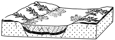
Figure 32--Concurrent shoulder uplift and graben subsidence result in erosion-sedimentation linkage over short distance. The conveyor-belt mechanism effects unloading of the shoulders and loading of the graben floor, both acting as additional energy input for the evolution of crustal rifting (From Illies, 1981).
Upper volcanic-dominated succession
Due to the considerable thicknesses and presumably extensive lava flows in the upper igneous-rich interval in the Poersch well, through-going fluvial systems might be less-frequent features of this portion of the rift sequence. Some flow tops are noted as simply weathered (oxidized) surfaces without appreciable sediment accumulation. Sediment could be alluvial-fan deposits derived from nearby fault blocks or more likely from granitic terranes forming the shoulders of the rift (Figure 29). Quartz content does not change markedly and frosted grains are not common. The maturity of interflow sediments appears to be less than the lower strata. These features along with limited sedimentation, without well-organized vertical packages support an alluvial-fan origin. Sedimentation and subsidence rates were probably less due to lack of thick sedimentary packages; evidence also can be seen in the cuttings for many weathering surfaces developed on the volcanic flows.
Basalt and gabbro dominate the upper succession. Thin pegmatite dikes and sills are common. The K-Ar ages of the gabbro and the pegmatite suggest that they are younger than the basalts and possibly genetically related. An extended period of volcanic activity accounted for the accumulation of the mostly alkaline basalts. Flow tops are difficult to identify from cuttings, but abundances of zeolites as infillings of amygdules, together with oxidation presumably related to subaerial exposure, are used as indicators. It is possible that large amounts of volcanics were removed prior to deposition of younger flows. A possible unconformity is indicated in the interval between 5,200-5,400 ft according to the reported K-Ar ages of the igneous rocks above and below. Oxidized surfaces are especially prevalent in the interval between 4,000-6,000 ft. The gabbro at the top of the Precambrian basement surface suggests that an unknown amount of rock was removed prior to deposition of the Ordovician sediments. The absence of known Precambrian marine materials anywhere in the vicinity of the rift except for one suggestion of Scott (1966) for marine conditions in the Rice Formation indicates that the area was emergent for an extended time prior to Paleozoic sedimentation. The gabbro still must be regarded as a shallow intrusive. The thickness of the lava flows is characteristic of transitional basalts in the Lake Superior region. No intermediate or felsic rocks of any consequence were encountered in the borehole.
VI. Preliminary conclusions
A total of 8,500 ft (2,580 m) of Precambrian rocks were penetrated. It is the deepest penetration to date in Kansas. The section may or may not be representative of sediments in general along the rift in Kansas. It is known from other Precambrian penetrations that the lithologies can vary drastically over short distances, which may be related to their position with respect to major structures. An example is effected by two boreholes, the Finn #1 and the Finn #1-4 in Marshall County, located one-half mile apart. More than 1,500 ft (450 m) of Precambrian rocks were penetrated in each well, yet comparison between the two shows little or no similarity in the lithologic succession.
We suggest that the Poersch #1 borehole is also located near one or possibly two intersecting tectonic zones. The Poersch #1 well is located on top of a major Precambrian anticlinal structure with a closure of about 5,000 ft (1,500 m) recognizable on seismic sections. Hence, the lithologies encountered may be different from those one could find elsewhere on this structure.
Comparison of the Poersch #1 rocks with those in the Lake Superior region shows no direct correlations can be made. However, the sedimentary and igneous rocks encountered in the Poersch well are decidedly synrift deposits. Sediment sources are predominantly shoulders of the rift but include minor volcanic fragments from the rift proper.
The largest exposed section of Portage Lake volcanics in Houghton County, Michigan, is about 7,500 m (24,750 ft) thick where interflow sedimentary rocks make up 3% of the rock volume. This is typical elsewhere in the Lake Superior region. In contrast, interbedded sediments in the Poersch #1 hole make up approximately 50% of the penetrated section.
Following the outpouring of basalt along the northern MRS, no flows occur in the younger sedimentary rocks of the Oronto or Bayfield Groups or their equivalents elsewhere. These units constitute a sequence of conglomerates, sandstone, and siltstone deposited in a basin overlying and alongside the rift zone. In contrast, we observe interbedded sedimentary rocks and basalt flows high up in the section. The sediments in the lower half of the hole probably should not be referred to as interflow deposits. They represent a much longer period of deposition. They also constitute a much larger percentage of the whole volume of rock (about 50%).
The post-volcanic-rift basin deposits of the northern MRS include the Oronto Group and Solar Church Formation. These units include the Copper Harbor Conglomerate, Nonesuch Shale, and the Freda Sandstone. The provenance for these deposits are primarily from within the rift from volcanic sources. In contrast, the primary source of synrift deposits in the Poersch appears to be from the rift shoulders. However, some of the detritus may be reworked arkosic sediment previously deposited in the rift. Without additional studies, judging the extent of recycling in these sediments is impossible.
It is the younger, latest synrift and post-rift (sag-basin) sedimentary rocks along the northern MRS that show a significant granitic source (Bayfield Group, Fon du Lac Formation, Hinkley Sandstone, and Jacobsville Sandstone). These units are not associated with active volcanism and are more widespread deposits, with little evidence for contemporaneous faulting. The sedimentary rocks in the Poersch well show lithologic affinities to these rocks, but resemble more closely the synrift deposits of the north in terms of structural framework in spite of a similar age according to the K-Ar. This supports younger rifting in the south similar to that proposed by McSwiggen et al. (1987), possibly initiated during a time of more limited volcanism. It is unclear how much more sedimentary rock lies beneath the Poersch; but the rift proper is narrower than to the north. A more proximal location of the rift shoulder would make the granitic detritus more available than to the north.
Geophysical evidence also supports a less well developed rift in southern Kansas marked by a narrow gravity high and parallel lineaments of gravity and magnetics.
Summary of conclusions
- The sedimentary rocks represent terrestrial detrital deposits, possibly laid down by alluvial fans, braided fluvial systems, and possibly aeolian accumulation.
- Rapid uplift and/or subsidence are suggested in the lower part of the succession by the type of sedimentary rocks present.
- Provenance was the nearby hinterland of older granitic basement adjoining the rift margin; possibly reworked arkosic sediment from adjacent fault blocks within the basin (particularly during alluvial-fan and cone sedimentation). Intrarift basalt was a source during earliest sedimentation in Poersch well.
- Climate was likely dry or at least seasonally dry, promoting flashy discharge.
- Rift timing was late according to dates provided by K-AR geochronology (roughly greater than 800 Ma, but less than 1,100 Ma). Rifting events to north apparently preceded active rifting observed in Poersch well. Rifting in the vicinity of the Poersch borehole could also have started at 1,100 Ma and continued for a prolonged period of time. The possibly controversial nature of these hypotheses places special stress on the validity of the Poersch #1 dates. Since all estimations were based on the K-Ar method, speculations concerning ft apparent youth of this section must remain tentative until confirmation or rejection by other age-dating techniques and more sample data.
- Sedimentary rocks in the Poersch borehole resemble late-stage synrift sedimentation. Evidence includes:
- correlation of the lithologic succession to the COCORP seismic profile and nearby faulting. Sedimentary packages characterized by textural and compositional immaturity, indicating short transport, rapid subsidence, or both;
- mafic igneous activity is minor in the lower portion of Poersch well, but is dominant in the upper portion;
- grand-scale sedimentary and igneous succession in the Poersch well is similar to synrift sedimentation in other rifts.
- The sediments generally have low porosity. They are generally denser than the values that have typically been used for geophysical modeling of the MRS. Assuming the sediments in the #1 Poersch are typical of the MRS in Kansas, a density of about 2.6 g/cc is appropriate for modeling.
- The individual mafic-lava flows in the Poersch # 1 hole are of the same order of magnitude of thickness as those observed in the Lake Superior region. In contrast the chemistry, especially the potassium content of the rocks, is much higher.
Additional geophysical studies, including seismic profiling, may provide us with answers to the following questions that are pertinent to our interpretation of where the Poersch #1 borehole rocks fit in.
- How thick is the total volcanic-sedimentary pile in the vicinity of the Poersch #1 borehole (preferably south of the major NW-trending fault just north of the hole)?
- What are the possible variations in thickness and composition of volcanic-sedimentary piles in other MRS rift basins that may be identified?
- What is the relationship between the volcanic and sedimentary rocks? Does one become more dominant with depth?
Topics for further studies and comparison of rifting in the Kansas sector of the MRS include:
- Succession and type of sedimentation and mafic igneous activity.
- Depositional environment, sedimentary trends; interpretation of sequences and tectono-stratgraphic history:
- evidence for erosion, weathering, unconformity development, faulting;
- evidence for swain, heating in the rocks;
- source-rock potential and potential reservoir rocks, thermal maturation, porosity;
- diagenetic history; stages of rifting.
- Correlation of lithic sequences to seismic reflectors in COCORP (Kansas):
- extrapolation along E-W section;
- structural style; tectono-stratigraphy;
- appraisal and prediction of other sedimentary deposits not encountered in Poersch well.
- Incorporate well data into magnetic and gravity modeling.
- Integrate geology, geophysics, and geochemistry to constrain interpretations.
Prev Page--Petrography and Logs || Next Page--References
Kansas Geological Survey, Texaco Poersch #1 Report
Placed on web March 5, 2010; originally published June 1988.
Comments to webadmin@kgs.ku.edu
The URL for this page is http://www.kgs.ku.edu/Publications/OFR/1988/OFR88_22/06_summ.html