![]()
Prev Page--Geography || Next Page--Ground Water, General
Geology in Relation to Ground Water
Summary of Stratigraphy
Note: The stratigraphic classification used in this report is that of the State Geological Survey of Kansas.
The rocks that crop out in Pawnee Valley are sedimentary and range in age from Cretaceous to Quaternary (Pl. 1). The oldest rocks exposed are Cretaceous and comprise the Dakota formation, Graneros shale, Greenhorn limestone, and Carlile shale. The Ogallala formation of Tertiary age caps the upland area in much of Hodgeman County. The terrace deposits that cover large areas adjacent to Pawnee River are believed to be Pleistocene in age but may be Tertiary in part. The alluvium in the principal valleys is Pleistocene.
A generalized section of the geologic formations of this area is given in Table 2.
Table 2--Generalized section of the geologic formations in Pawnee Valley, Kansas.
| System | Series | Subdivision | Thickness (feet) |
Physical character | Water supply |
|---|---|---|---|---|---|
| Quaternary | Pleistocene* | Alluvium | 0-135 | Coarse sand and gravel containing silt and clay. Sand and gravel generally overlain by 15 to 50 feet of silt and clay. | Yields large quantities of water to domestic, stock, and irrigation wells. |
| Terrace deposits | 0-150 | Principally silt and clay but locally contains considerable sand and gravel. | Yields moderate supplies of water to domestic and stock wells and to a few irrigation wells. | ||
| Tertiary | Pliocene | Ogallala formation | 0-100 | Consists mainly of silt, sand, and gravel containing caliche. | Yields fair amounts of water for stock and domestic wells in parts of Ness and Hodgeman Counties. |
| Cretaceous | Gulfian* | Carlile shale | 0-100 | Chalky shale containing thin beds of chalky limestone. | Yields small quantities of water to wells in adjacent area but not known to yield water to wells in this area. |
| Greenhorn limestone | 0-125 | Chalky shale containing thin beds of crystalline limestone at base and granular to chalky limestone in upper part. | Yields small quantities of water to dug wells in northern Pawnee County. | ||
| Graneros shale | 20-36 | Dark-gray shale containing sandy shale and lenses of sandstone. | Yields no water to wells in this area. | ||
| Dakota formation | 20-300 | Consists principally of buff, yellow-brown, and brown sandstone and vari-colored clay and sandy clay. | Yields small to moderate quantities of water to domestic and stock wells. | ||
| Comanchean* | Kiowa shale | 100-230 | Dark-gray to black shale containing lenses of sandstone. | Yields no water to wells in this area. | |
| Cheyenne sandstone | 15-50 | Gray, tan, and white fine to medium-grained sandstone. | Yields no water to wells in this area due to its considerable depth. Water may be highly mineralized. | ||
| *Classification of the State Geological Survey of Kansas. | |||||
Cretaceous System
Cheyenne Sandstone
Character--The Cheyenne sandstone does not crop out in Pawnee Valley; hence, little is known of its lithologic character in this area except as determined by the cuttings from test holes (McLaughlin, 1949, Pl. 3). The formation has been described in detail by Latta (1946, 1948) at the type locality near Belvidere which is about 20 miles south of the south line of Edwards County. Latta states (1946, p. 235):
The Cheyenne consists chiefly of light-colored fine- to medium-grained friable cross-bedded sandstone and lenses of sandy shale and conglomerate. Minor amounts of clay, selenite crystals, iron nodules, and pyrite occur in different parts of the formation. . . . Sandstone is by far the most dominant type of rock in the Cheyenne. The most common colors of the sandstone are white, light gray, and tan, but in some places iron staining has produced beautiful shades of yellow, red, purple, and brown along bedding and lamination planes or in irregular splotches. The brightly colored zones are most common in the upper half of the formation. The texture of the sandstone ranges from flour-like material of silt and clay size to fine gravel, but fine- to medium-grained sandstone is most common. The material in general is well sorted although the degree of assortment varies from one part of the formation to another and from one locality to another.
The material encountered in test holes drilled by the State and Federal Surveys is primarily fine- to medium-grained sandstone containing gray and gray-green shale and a little siltstone.
Distribution and thickness--The Cheyenne sandstone probably underlies all or most of Pawnee Valley considered in this report (McLaughlin, 1949, Pl. 3) as well as large areas of southwestern Kansas except in some of the counties in the southern tier. It crops out in very few places in southwestern Kansas. The principal localities are in the Belvidere area in southeastern Kiowa County (Latta, 1946) and in adjacent areas in Comanche and Barber Counties.
The thickness of the Cheyenne sandstone has been reported by Latta (1946) to range from 32.5 to 94 feet in the Belvidere area and to average about 45 feet. The thickness of the formation in Pawnee and Edwards Counties ranges from 19 to 95 feet (McLaughlin, 1949) and averages about 27 feet.
Water supply--In most places in Pawnee Valley adequate supplies of water of good quality can be obtained from younger formations above the Cheyenne sandstone. As few wells have been drilled into the Cheyenne, little information is available regarding the quality and quantity of the water. The Cheyenne is permeable enough in most places to supply water for stock and domestic purposes, but it occurs at a depth of more than 350 feet and quite frequently the water is highly mineralized so that it is undesirable in Pawnee Valley to drill wells to the Cheyenne. Chemical analyses of waters from two wells that tap the Cheyenne sandstone in Kiowa County are reported by Latta (1948, p. 86). The waters from both wells are highly mineralized, having, respectively, 9,235 and 3,138 parts per million of dissolved solids, 3,068 and 1,075 parts of sodium and potassium, 1,141 and 277 parts of sulfate, 4,588 and 1,560 parts of chloride, and 1,090 and 330 parts of hardness.
Kiowa Shale
Character--The Kiowa shale does not crop out in Pawnee Valley. The lithologic character of the Kiowa shale is known only from cuttings from test holes and from its exposures in adjacent areas, particularly in the type locality near Belvidere in Kiowa County.
Latta (1946, p. 244) describes the Kiowa shale in the vicinity of the type locality as follows:
The Kiowa shale consists dominantly of thinly laminated dark-gray to black shale in the lower part grading upward to gray, tan, mottled tan, red, and brown clay and clay shale. The shale in the lower part generally is black and has been called a paper-shale because it is so thinly laminated. A conspicuous feature of the formation, especially of the lower part, is the presence of thin beds of shell limestone. . . .
Latta states that large lenses of sandstone occur at the top of the formation in some places and that thin lenses of sandstone occur throughout the formation.
The material encountered in test drilling through the Kiowa shale in Pawnee and Edwards Counties consisted principally of light- to dark-gray and black clay-shale containing thin beds of sandstone (McLaughlin, 1949). Thin layers of pyrite were encountered in several of the test holes. A hard layer of limestone that may be equivalent to one of the beds of shell limestone was encountered in test hole 28 at a point 78 feet above the base of the formation. Small fragments of limestone were noted in some of the other test holes.
Distribution and thickness--The Kiowa shale crops out in small areas in Kiowa, Clark, Comanche, and Barber Counties and over a wide area in central Kansas. The formation underlies all of Pawnee Valley included in this report and Much of southwestern Kansas where it is concealed in most places beneath Cretaceous, Tertiary or Quaternary rocks.
The maximum reported thickness of the Kiowa shale is 293 feet in the Belvidere area (Latta, 1946). The formation has a maximum thickness of 125 feet in central Kansas and about 135 feet in southwestern Kansas. The thickness of the formation in Pawnee and Edwards Counties ranged from 133 to 222 feet and averaged about 180 feet (McLaughlin, 1949).
Water supply--No wells in Pawnee Valley obtain water from the Kiowa shale. Small quantities of water may be available from beds of sandstone within the Kiowa, but larger quantities of potable water are available from overlying formations.
Dakota Formation
Character--The Dakota formation consists principally of buff, yellow-brown, and brown sandstone and varicolored clay and sandy clay. Where the formation is exposed, the sandstone may be thin-bedded to massive but generally is strongly ripple-marked and cross-bedded. Where the sandstone is well cemented, as at Larned, it forms steep bluffs. In other areas, however, the beds of the formation are poorly cemented and form low smooth hills having a thick cover of soil. For this reason the outcrops in many areas are far apart or are absent, and the contacts between the Dakota and younger formations are difficult to map.
In a few places in Pawnee County there are zones of hard ironstone and very hard quartzitic sandstone. These deposits weather to large rounded boulders and hard outcropping ledges (McLaughlin, 1949, pl. 7).
Distribution and thickness--The Dakota formation crops out in isolated areas in Pawnee County (Pl. 1) in the vicinity of Larned and Burdett; in Hodgeman County the formation crops out in large areas south of Buckner and Sawlog Creeks. The Dakota underlies all of Pawnee Valley considered in this report.
The Dakota is reported to attain a maximum thickness of about 275 feet in north-central Kansas (Plummer and Romary, 1942, p. 330). The average thickness of the Dakota in Pawnee and Edwards Counties is believed to be about 200 feet (McLaughlin, 1949). According to Moss (1932, pp. 32, 45) the Dakota formation has a thickness of more than 300 feet in Ness and Hodgeman Counties.
Water supply--The Dakota formation yields small to moderate quantities of water to many wells in the Pawnee Valley area. Most of the domestic and stock wells in the Dakota have a small diameter and yield only small quantities of water. The large-diameter public-supply wells at Larned have yields ranging from 125 to 150 gallons a minute. The water supply for the City of Utica located northwest of this area is obtained from the Dakota and several years ago the water supply for Ness City was obtained from the Dakota.
The water in the Dakota is generally under artesian pressure. A flowing artesian well located southeast of Jetmore furnishes enough water for irrigating a large garden.
The Dakota supplies water to wells in the outcrop area and where it is overlain only by relatively impermeable materials such as those in the Graneros, Greenhorn, and Carlile formations. Where the Dakota is overlain by coarse water-bearing materials as in the Pawnee Valley, wells generally obtain an adequate supply of suitable water in the overlying materials.
Water from the Dakota formation generally contains a large amount of dissolved solids but is comparatively soft (Table 20). However, a sample of water collected from well 22-21-25aa contained only 111 parts per million of dissolved solids and had a hardness of 30 parts per million. Where the Dakota is overlain by a large thickness of younger deposits, the water may be highly mineralized.
Graneros Shale
General description--The lithology of the Graneros shale is variable. In some places it consists entirely of dark-gray to black fissile argillaceous shale, whereas in other places it consists of shale, sandy shale, and sandstone. The formation is soft in most localities and forms a gentle slope between the Greenhorn limestone and the Dakota formation.
The thickness of the Graneros shale in the Pawnee Valley area is not known but is believed not to exceed about 35 feet. Moss (1932) observed a maximum thickness of 36 feet in Hodgeman County but stated that the thickness in that area was variable and in most places was less than 30 feet.
The Graneros shale yields little or no water to wells in the Pawnee Valley area.
Greenhorn Limestone
Character--The Greenhorn limestone consists largely of a succession of thin chalky to crystalline limestones interstratified with thicker beds of gray calcareous shale. The shales contain thin beds of bentonitic clay. The formation has been divided into four units in this area, including the Pfeifer shale member at the top, the Jetmore chalk member, the Hartland shale member, and the Lincoln limestone member at the base. The base of the formation is marked by an abrupt change from the calcareous beds of the Greenhorn to the noncalcareous shale and sandy shale of the Graneros. The top of the formation is marked by the Fencepost limestone bed, which is a prominent bed of relatively bard chalky limestone that is quarried extensively in north-central Kansas for use as fence posts.Distribution and thickness--The Greenhorn limestone crops out north of Pawnee Valley in northwestern Pawnee County, on both sides of Pawnee Valley in southern Ness County, and in the bluffs along Buckner and Sawlog Creeks in Hodgeman County. According to Moss (1932, p. 26)
The thickness of the formation is approximately 125 feet in Hodgeman County. The entire section is not exposed at any one place, and so measurements were made of the beds exposed in various places and correlated to obtain the total thickness. Part of the middle of the formation is not exposed in Ness or Hodgeman counties, so was measured in Ford County, just south of the Hodgeman County line.
Water supply--Very few wells that receive their entire water supply from the Greenhorn limestone were observed in the Pawnee Valley area. The water-yielding capacity of the formation is low, and very small supplies of comparatively hard water may be expected from wells penetrating this formation.
Carlile Shale
Character--The Carlile shale consists of the Codell sandstone member at the top, the Blue Hill shale member, and the Fairport chalky shale member at the base. The basal Fairport chalky shale member is the only part of the Carlile exposed in the area considered by this report. According to Moss (1932) the Blue Hill shale member crops out in a band 2 to 5 miles wide extending from the northeast to the southwest corner of Ness County and crosses the northwest corner of Hodgeman County.
The Fairport chalky shale member consists of thick beds of chalky shale alternating with thin beds of chalky limestone. The thick beds of chalky shale contain flat concretions and a few beds of bentonite. The lower, more resistant beds of chalky limestone form small terraces whereas the upper beds erode to smooth, rounded soil-covered hills.
Distribution and thickness--The Fairport chalky shale member covers large areas in Ness and Hodgeman Counties but in Pawnee County it crops out only in the northern part. The Fairport caps the divide between Walnut Creek and Pawnee River and it crops out along both sides of Pawnee River and Buckner Creek in Hodgeman County.
Moss (1932, p. 23) reports that no measurement of the thickness of the Fairport chalky shale member could be made in Ness and Hodgeman Counties as there are no exposures of the upper part. McLaughlin (1949, p. 82) believes that the thickness of the Carlile shale in Pawnee County nowhere exceeds 100 feet.
Water supply--Meager supplies of water are obtained from a few shallow dug wells in the Carlile shale. The water is obtained from the joints and bedding planes of chalky limestone in the lower part of the formation. Generally, if there are no overlying deposits which yield an adequate water supply, wells are drilled through the Carlile into the Dakota formation even though the Dakota water may be highly mineralized.
Water from the Carlile shale is hard but can be used for domestic and stock purposes.
Tertiary System
Pliocene Series
Ogallala Formation
Character--The Ogallala formation consists mainly of silt, sand, and gravel containing caliche. The mortarlike appearance of the gritty beds that have been cemented has caused them to be called "mortar beds." The "mortar beds" are the most conspicuous part of the formation because they are resistant to erosion and form benches and, in some cases, vertical bluffs. As the Ogallala formation is more resistant than most of the underlying Cretaceous strata, there is a distinct topographic break in most places at the contact. Moss (1932, p. 13) stated,
On the north-facing slopes the Ogallala beds form a steep slope, and along the northward-flowing streams they have been eroded into steep-walled valleys. Many of the northward-flowing tributaries of Buckner and Sawlog creeks are locally known as "canyons." On the south-facing slopes the topographic break is usually not pronounced and in places may not be evident, so that there is a gentle, unbroken slope from the top of the Ogallala down across lower strata to the bottom of the valleys.
Distribution and thickness--The Ogallala formation crops out in northwestern Edwards County and in a few scattered areas in Pawnee County (McLaughlin, 1949, p. 82). Thin patches of algal limestone overlie the Dakota formation at many places in Pawnee County. The Ogallala formation caps the plateau-like uplands that make up about a third of the area of Ness and Hodgeman Counties (Moss, 1932). The formation caps the divide areas between Pawnee River and Buckner Creek and between Buckner Creek and Sawlog Creek. It also covers most of the area to the east of Sawlog Creek in southeastern Hodgeman County.
The Ogallala formation is 66 feet thick at a test hole at the northwest corner of sec. 15, T. 23 S., R. 20 W. but may be nearly 100 feet thick at the Edwards-Hodgeman county line (McLaughlin, 1949, p. 82). Moss (1932, p. 13) reports a maximum thickness of 100 feet in Hodgeman County, and Waite (1942, p. 158) stated that it may be as much as 250 feet thick in Ford County.
Water supply--The Ogallala formation yields moderate quantities of water for stock and domestic wells in many parts of Ness and Hodgeman Counties and yields small quantities to a few domestic and stock wells in the northwestern part of Edwards County (McLaughlin, 1949). The formation in this area is the eastern fringe of the High Plains and in general is highly dissected. Also, the Ogallala overlies high areas of Cretaceous rocks so that much of the formation is largely drained of water. However, in local areas, properly constructed wells yield adequate supplies of water for stock and domestic use.
Quaternary System
Pleistocene Series
Terrace Deposits
Character--The terrace deposits consist principally of light-tan to brown clay and silt containing some caliche and is interbedded with fine to coarse sand and some gravel. The silt and clay, which generally are brown or buff, may have a variety of colors ranging from white to bright-green and blue. The sand and gravel is poorly sorted and generally occurs at the base of the deposits. The gravel pebbles consist principally of limestone, sandstone, and ironstone which probably were derived from the Greenhorn, Carlile, and Dakota formations. Locally, the terrace deposits contain thick deposits of gravel and sand which furnish adequate supplies of water for irrigation from wells.Distribution and thickness--The extent of the terrace deposits in Pawnee Valley is shown on the geologic map (Pl. 1) and their thickness and character are given by cross sections in Plate 3 and logs of test holes at the end of this report. Terrace deposits overlie the Cretaceous rocks on both sides of Pawnee River throughout most of Pawnee County and extend into Ness and Hodgeman Counties. Thick terrace deposits occur along the north side of Sawlog and Buckner Creeks to a point a few miles upstream from Hanston. Remnants of terraces have been observed farther upstream along Pawnee River and its tributaries, but owing to their small areal extent, discontinuous nature, and small importance as water-bearing material, the remnants of terraces in the upstream areas have been included with the alluvium on the geologic map.
According to McLaughlin (1949, p. 86):
Two terraces can be observed in many places adjacent to the Pawnee Valley, but in some areas they are difficult to recognize because of dissection by streams tributary to Pawnee and Arkansas Rivers. The lowermost terrace, which is the most prominent, is about 20 feet above the flood plain of Pawnee River and the upper terrace is about 50 or 60 feet above the flood plain.
The thickness of the terrace deposits ranges from a featheredge near their contact with the Cretaceous bedrock to more than 100 feet in some places. At test hole 21-21-14cb the terrace deposits have a thickness of 152 feet. The average thickness of the terrace deposits along Pawnee Valley in Pawnee County is about 60 feet (McLaughlin, 1949, p. 88).
Water supply--Inasmuch as the terrace deposits consist primarily of clay and silt, the formation generally yields only small to moderate quantities of water to wells. Generally, sufficient water for most domestic and stock uses can be obtained from the thin beds of sand and gravel. In places where the deposits contain much sand and gravel the beds will yield adequate water for irrigation. In general, however, wells in these beds will not yield enough water for irrigation.
Water from the terrace deposits is moderately bard but otherwise is of good quality.
Alluvium
Character--The alluvium of Pawnee Valley consists of sand, gravel, silt, and clay. The upper part of the alluvium consists predominantly of clay and silt containing some sand. McLaughlin (1949, p. 89) found that this zone of silt and clay ranges in thickness from about 15 feet to 50 feet and has an average thickness of about 30 feet. These thick deposits of clay and silt retard and limit the quantity of ground-water recharge from local precipitation. Beneath the silt and clay there is, in most places, a thick deposit of gravel and sand that yields large quantities of water to wells in the valley.
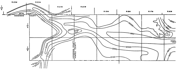
Distribution and thickness--Alluvium underlies the bottomland of Pawnee River and some of its larger tributaries. The extent of the alluvium is shown on the geologic map (Pl. 1) and its thickness and character are shown by cross sections in Plate 3 and by logs of test holes at the end of this report. The alluvium of Pawnee Valley has a width of as much as 3 miles in parts of Pawnee Valley and as much as 2 miles in Hodgeman and Ness Counties. The thickness of the alluvium in Pawnee County as determined by 15 test holes ranged from 65 to 138 feet and averaged 105 feet (McLaughlin, 1949, p. 89). In the cross sections shown on Plate 3 the alluvium in Ness and Hodgeman Counties has a maximum thickness of about 100 feet. The alluvium in Buckner and Sawlog Creeks generally has a thickness of not more than 70 feet, but in few places has a thickness of as much as 100 feet. The base of the alluvium is shown by the bedrock contour map (Fig. 5).
Figure 5--Contours on the bedrock in Pawnee Valley.
Water supply--The alluvium of Pawnee, Buckner and Sawlog Valleys yields large quantities of water to wells. Most of the domestic and stock wells and all the irrigation wells in the valleys obtain water from the sand and gravel of the alluvium. A discussion of the large quantity of water pumped from the alluvium for irrigation is given in the section on irrigation. The water in the alluvium is hard but generally is suitable for most domestic, stock, and irrigation uses.
Prev Page--Geography || Next Page--Ground Water, General
Kansas Geological Survey, Geohydrology
Placed on web May 31, 2012; originally published April 1952.
Comments to webadmin@kgs.ku.edu
The URL for this page is http://www.kgs.ku.edu/Publications/Bulletins/94/04_geol.html