![]()
Prev Page--Introduction || Next Page--Geology
Geography
Topography and Drainage
The area included in this report includes Pawnee River Valley and the main tributaries of Pawnee River-Sawlog Creek Valley, Buckner Creek Valley, and Sawmill Creek Valley. Flat bottomlands and terraces are the principal topographic features of the area. Pawnee Valley consists of a relatively flat alluvial plain transected by many abandoned channels of Pawnee River. Adjacent to the bottomland is a broad flat terrace which locally is as much as a mile wide. Pawnee River has an average gradient of about 2 feet per mile.
Climate
About 76 percent of the precipitation in this area falls during the 6-month period from April 1 through September 30. The U. S. Weather Bureau has maintained a precipitation gauge at Ness City since 1893, at Jetmore since 1901, and at Larned since 1880. The distribution of the normal precipitation at Ness City, by months, is given in Table 1. The annual precipitation and the cumulative departure from normal precipitation for the station at Ness City for the period of record beginning in 1893 are shown graphically in Figure 3. The precipitation has ranged from a minimum of 7.96 inches in 1894 to a maximum of 32.41 inches in 1944. The normal annual precipitation is 20.38 inches.
Table 1--Normal monthly precipitation at Ness City
| Month | Precipitation, inches |
|---|---|
| January | 0.30 |
| February | 0.79 |
| March | 0.95 |
| April | 2.08 |
| May | 3.00 |
| June | 3.33 |
| July | 2.57 |
| August | 2.50 |
| September | 2.04 |
| October | 1.40 |
| November | 0.82 |
| December | 0.60 |
Figure 3--Annual precipitation and cumulative departure from normal precipitation at Ness City, Kansas. (Data from U. S. Weather Bureau.)
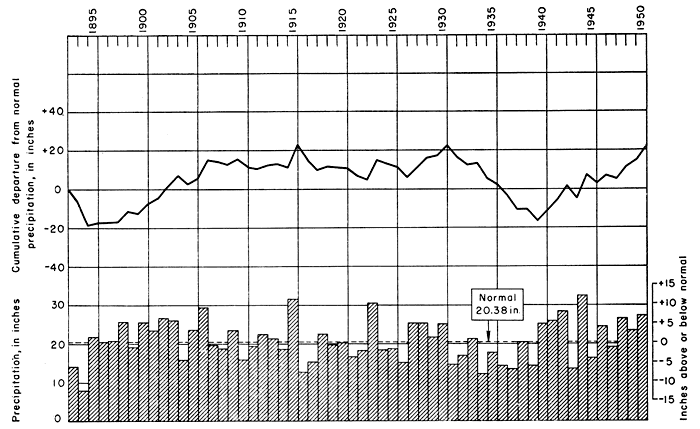
Figure 4--Annual precipitation and cumulative departure from normal precipitation at Jetmore, Kansas. (Data from U. S. Weather Bureau.)
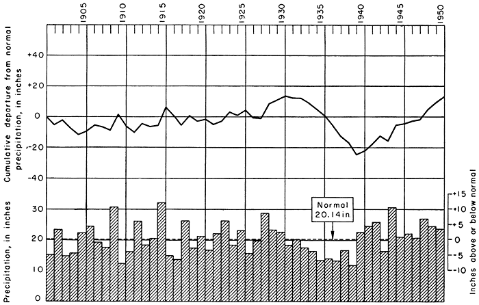
The normal annual precipitation recorded at Jetmore is 20.14 inches. The annual precipitation and the cumulative departure from normal precipitation at Jetmore for the period of record beginning in 1901 are shown graphically in Figure 4. The precipitation has ranged from a minimum of 11.93 inches in 1939 to a maximum of 32.09 inches in 1915.
The normal annual precipitation recorded at Larned is 23.48 inches. The precipitation at Larned has ranged from a minimum of 7.97 inches in 1872 to a maximum of 39.63 inches in 1915.
Transportation
The Atchison, Topeka, and Santa Fe Railway Company has a spur line that extends from Larned to Jetmore. The communities served by this spur line are Frizell, Sanford, Rozel, Burdett, and Hanston.
The principal highways crossing Pawnee Valley are U. S. Highways 50 North, 183, 283, and Kansas Highway 45. U. S. Highway 50 North passes through or near Larned, Sanford, Rozel, Burdett, Hanston, and Jetmore. U. S. Highway 183 is a north-south highway that crosses the valley near Sanford and Rozel. U. S. Highway 283 is a north-south highway that passes through Ness City and Jetmore. State Highway 45 passes through Larned and follows the Arkansas River Valley in this area.
Pawnee Valley has many excellent county highways, some of which are hard-surfaced roads and others which have been surfaced with sand and gravel.
Prev Page--Introduction || Next Page--Geology
Kansas Geological Survey, Geohydrology
Placed on web May 31, 2012; originally published April 1952.
Comments to webadmin@kgs.ku.edu
The URL for this page is http://www.kgs.ku.edu/Publications/Bulletins/94/03_geog.html