![]()
Prev Page--Contents || Next Page--Geography
Introduction
Purpose and Scope of the Investigation
According to a survey made by Kenneth D. McCall and Milburn H. Davison of the Division of Water Resources, Kansas State Board of Agriculture, approximately 16,800 acres of land in Pawnee River Valley were under irrigation in 1939. Of the land under irrigation, about 8,700 acres were irrigated with water pumped from wells, about 6,000 acres were irrigated with water pumped from streams, and about 2,100 acres were irrigated with water pumped from wells and streams. There were 134 irrigation wells, 95 stream pumping plants, and 30 small dams in operation in 1939.
Irrigation with ground water in Pawnee Valley has been increasing for many years. That ground-water developments cannot be expanded indefinitely without causing overdevelopment is now recognized; hence, this investigation was made to determine the present utilization of ground water in the valley, under what conditions recharge and natural discharge occur, at what depth below the land surface water lies, the distribution of water-bearing materials beneath the surface of the land, the capacity of the water-bearing materials for storage and yield, the chemical character of the ground water, and many other pertinent facts.
The field work on the present investigation was begun in July 1945 by the United States Geological Survey and the State Geological Survey of Kansas in cooperation with the Division of Sanitation of the Kansas State Board of Health and the Division of Water Resources of the Kansas State Board of Agriculture.
The investigation was made under the general administration of A. N. Sayre, Chief of the Ground Water Branch of the U. S. Geological Survey.
Location and Extent of the Area
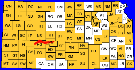
The part of Pawnee Valley considered in this report is located in Ness, Hodgeman, and Pawnee Counties. It extends from the mouth of Pawnee River at Larned to 7 miles west of U. S. Highway 283. Consideration is given to some of the main tributaries of Pawnee River including Sawlog, Dry, Buckner, and Sawmill Creeks. The location of the area is shown by Figure 1.
Figure 1--Area covered by this report and other areas for which cooperative ground-water reports have been published or are in preparation.
Previous Investigations
Geologic and hydrologic studies in western Kansas were made in 1895 by Haworth (1897), who discussed the regional geology and the occurrence of ground water in the Dakota and younger formations. Johnson (1901, 1902) reported on the utilization of the southern High Plains with special reference to the source, availability, and use of ground water in western Kansas. Darton (1905), in describing the geology and ground-water resources of the Central Great Plains, discussed the general geology and stratigraphy of western Kansas. Records of water wells in Ness and Hodgeman Counties are included in his report. Parker (1911) briefly described the geology and ground-water resources of this area in his report on the chemical character of the water supplies of Kansas. A report by Rubey and Bass (1925) contains detailed descriptions and correlations of the Cretaceous strata and names a chalk member of the Greenhorn limestone for the town of Jetmore in Hodgeman County. Courtier (1934) mapped the geology of much of this area as a part of his study of south-central Kansas.
In 1932 Moss published a detailed description of the geology of Ness and Hodgeman Counties. Reports on geology and groundwater resources of Ford County (Waite, 1942), Finney and Gray Counties (Latta, 1944), and Barton and Stafford Counties (Latta, 1950) have been published. A report by McLaughlin (1949) gives the results of a detailed investigation of the geology and ground-water resources of Pawnee and Edwards Counties. That report includes the eastern one-half of the area described in this report.
Methods of Investigation
The field work for this report was begun in July 1945. An investigation of the geology and ground-water resources of Pawnee County which was started during the summer of 1944 by T. G. McLaughlin included that part of Pawnee Valley in Pawnee County. In July 1945 the study of the ground-water resources of Pawnee Valley was extended to include the valley area in Ness County and part of Hodgeman County. The geology of the valley was mapped by McLaughlin during the summer of 1945. A total of 316 wells in the valley area were visited, and the total depth and depth to water level below land surface in most of them were measured with a steel tape. The well inventory was made largely by J. Milton Sears, R. W. Ball, and Nels Florell. Well owners and drillers were interviewed regarding the nature and thickness of the water-bearing formations penetrated by the wells, and all available logs were collected. Information was obtained regarding the yield, drawdown, temperature of water, chemical character of the water, and the use of ground water.
Periodic measurements, generally monthly, of the water levels in eight observation wells in Pawnee Valley were started in August 1940. Measurements were discontinued on one well in December 1948 but they have been continued in the other seven wells since 1940.
Samples of water collected from 60 representative wells were analyzed by Howard A. Stoltenberg, chemist, in the Water and Sewage Laboratory of the Kansas State Board of Health at Lawrence.
During the fall of 1946 and the summer of 1947, 111 test holes were drilled in the area by O. S. Fent and Delmar W. Berry, geologists, and William T. Connor and Joseph Votaw using the hydraulic-rotary drilling machine owned by the State Geological Survey of Kansas. The locations of the test holes are shown on Plate 2. Samples of the material penetrated by the drill were collected and are described in the logs at the end of the report.
Altitudes of the measuring points were established by spirit leveling at each of the wells and the test holes. The levels were run by Charles K. Bayne and W. W. Wilson. The contours of the water table shown on Plate 2 are based on water-level altitudes in wells as referred to the altitudes of the measuring points.
Field data were compiled on a county map prepared by the State Highway Commission. Drainage data were taken from maps prepared by the Soil Conservation Service and from aerial mosaics obtained from the United States Department of Agriculture, Agricultural Adjustment Administration.
Well-Numbering System
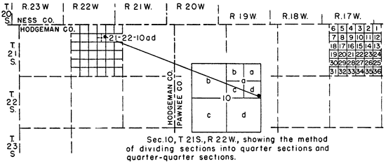
The well and test hole numbers used in this report give the locations of wells according to General Land Office surveys and according to the following formula: township, range, section, 160-acre tract within that section, and the 40-acre tract within that quarter section. This system of numbering wells is shown graphically on Figure 2. The 160-acre and 40-acre tracts are designated a, b, c, or d in a counterclockwise direction beginning in the northeast quarter. For example, well 21-22-10ad is located in the SE NE sec. 10, T. 21 S., R. 22 W. If two or more wells are located within a 40-acre tract, the wells are numbered serially according to the order in which they were inventoried.
Figure 2--Index map illustrating the well-numbering system used in this report.
Acknowledgments
The writer acknowledges the help of many residents of the area, especially those who gave permission to measure their wells, and who supplied helpful information regarding them. The operators of most of the irrigation wells were very cooperative and supplied much information regarding their wells. Special acknowledgment is given to the owners of nine irrigation wells for permitting us to make pumping tests on their wells and to Elias Hoagland, tenant on the Norris farm, for his helpful cooperation during the pumping test on the Norris irrigation well.
The geology was mapped by T. G. McLaughlin and the geologic map on Plate 1 was prepared by him. The manuscript for this report has been critically reviewed by several members of the Federal and State Geological Surveys: George S. Knapp, Engineer, and Robert Smrha, Chief Engineer, of the Division of Water Resources of the Kansas State Board of Agriculture: and Dwight Metzler, Director, and Willard Hilton, Geologist, of the Division of Sanitation of the Kansas State Board of Health.
Prev Page--Contents || Next Page--Geography
Kansas Geological Survey, Geohydrology
Placed on web May 31, 2012; originally published April 1952.
Comments to webadmin@kgs.ku.edu
The URL for this page is http://www.kgs.ku.edu/Publications/Bulletins/94/02_intro.html