![]()
Prev Page—McLouth Sand || Next Page—Production, Character, and Future
Paleogeography and Environment of the Forest City Basin during Early Cherokee Time
At the beginning of Cherokee time, the Forest City basin was a detached northern extension of the Cherokee basin of Oklahoma from which it was separated by the Bourbon arch, a broad low structural feature underlain by Mississippian limestone. A similar arch north of the Ozark region in Missouri separated the Forest City basin from the Illinois basin to the east. The region of the Ozark uplift, southeast of the Forest City basin, was a land mass of low elevation underlain mainly by cherty dolomites of late Ordovician age flanked by beveled Mississippian limestones. The re-elevation of the Nemaha anticline had formed an eastward-facing escarpment which was the western boundary of both the Cherokee basin and the Forest City basin. Areas of granite not exceeding 1,400 square miles, bordered by early Paleozoic rocks, were exposed on the beveled crest of this anticline in northern Kansas and southeastern Nebraska, but toward the south early Paleozoic and Mississippian limestones were exposed on the crest. The elevated region west of the escarpment was underlain mainly by Mississippian and Devonian limestones but still farther west, in the area of central Kansas, Ordovician dolomites with local outcrops of granite were exposed (McClellan, 1930, p. 1542). Toward the north and northeast, a land area seems to have existed in Minnesota, Wisconsin, and adjoining areas to the north, for the Cherokee rocks become thinner in this direction. Mississippian and older Paleozoic rocks also wedge out on pre-Cambrian rocks in the same direction (Ballard, 1942, p. 1571). Part of the land area of igneous and metamorphic rocks probably drained into the Forest City basin and thus could have been the source of at least a part of the Pennsylvanian sediments of that area.
The Cherokee basin of southeastern Kansas is the northern extension of the much deeper Ouachita basin of southern Arkansas and southeastern Oklahoma. The Ouachita basin is bordered on the south by the Ouachita mountains which were rising contemporaneously with the subsidence of the basin. There seems to be no reason to doubt that the sediments accumulating in the Ouachita basin were derived mainly from the Ouachita mountains. It seems probable, therefore, that most of the early sediments introduced into the Cherokee basin were derived also from this source, although to reach the northern end of the Cherokee basin the materials must have been carried across the aggrading Ouachita basin and into the northern reaches of the narrowing tributary Cherokee basin. After the burial of the Bourbon arch, however, sediments from the north probably mingled with those from the south.
The upper and middle Cherokee sediments of the Forest City basin extend southward through eastern Kansas and western Missouri into the Cherokee basin in southeastern Kansas and eastern Oklahoma. The Cherokee deposits are thinner on the broad divide (Bourbon arch) than in the basins to the north and south, as shown by the isopachous map in the report by Bass (1936, pl. 1) on the shoestring sands of Greenwood and Butler counties, Kansas. Similar relations occur in northern Missouri on the slightly higher divide between the Forest City basin and the Illinois basin. Thus, although the Forest City basin is believed by the senior writer to have been at first a separate structural and topographic depression, sedimentation was in progress during late Cherokee time from the Illinois basin westward through northern Missouri and southern Iowa to the Forest City basin, and thence southward through eastern Kansas and western Missouri to the Cherokee basin.
The early deposits in the deep central part of the Forest City basin consist of black shale with very small amounts of sand or sandy shale. Above the black shale, the Cherokee sediments consist largely of quartz sand, silt, mica, and clay. Grains of feldspar also occur and beds of arkose were deposited especially in the western and central parts of the basin. Most of the land draining into the Forest City basin was underlain by limestones and dolomites from which the mica, quartz sand, and feldspar of the Cherokee could not have been derived. The relatively small area of granite exposed on the crest of the Nemaha anticline is inadequate to account for the vast quantities of quartz sand and mica of the Cherokee, although the arkose was probably derived at least in part from the Nemaha anticline. The region of the Central Kansas uplift, although underlain in some places by granite, does not seem to have drained into the Forest City basin. Much of the early clastic deposits of the Forest City basin, except possibly the arkose, may have been derived, therefore, from the area toward the north if the Bourbon arch actually formed a topographic barrier confining the Forest City basin.
The development of the Forest City basin between post-Mississippian base leveling and deposition of the Fort Scott limestone is clearly revealed by the evidence now available. The detailed steps by which the Nemaha anticline was faulted and re-elevated and the surface of the post-Mississippian peneplain depressed to form the Forest City basin are still obscure partly due to lack of adequate well samples and partly because no broadly recognizable datum beds have yet been established in the lower Cherokee rocks.
The senior writer advocates the theory that both the Forest City basin and the Cherokee basin were developed by a long series of minor movements deforming the peneplain east of the Nemaha anticline escarpment. Greater depression resulted in the areas north and south than on the Bourbon arch. It is presumed that the slowly developing Cherokee basin drained into the much larger Ouachita basin toward the south and that at first no sediments accumulated in this basin in Kansas. The Forest City basin north of the Bourbon arch, on the other hand, because of its closed character was almost contemporaneously filled with black shale deposits as the differential subsidence took place. When the Cherokee basin finally became filled with aggrading deposits advancing from the south, the Bourbon arch was buried and the Forest City basin merged with the Cherokee basin.
H. S. McQueen and some other geologists (oral communications) support a theory which implies that the beveled and peneplaned surface of the Mississippian limestones was widely covered by black shale deposits before the beginning of the Forest City and Cherokee basin movements. This theory assumes that the Nemaha anticline was rejuvenated after and not before the deposition of the black shale; that the shale was stripped from the crest of the ridge after re-elevation, thus re-exposing the granite areas at the north end of the anticline; and that the re-elevated granite areas were the source of the arkose which then spread out over the beveled surface of the black shale in the Forest City basin. This theory implies that neither of the basins nor the Bourbon arch were developed until after the deposition of the black shale and that the Forest City and Cherokee basins were never separate topographic entities. The theory is not without merit, but there is evidence to indicate that the early Cherokee sediments in southeastern Kansas advanced into a previously developed basin and that the earliest Cherokee sediments in the Cherokee basin differ markedly in content of sand and coal from those in the Forest City basin.
These two theories might be reconciled by assuming that the black shale accumulated in the differentially subsiding Forest City basin independently of the Cherokee basin, as in the first theory, but that at the close of the time of black shale accumulation in the Forest City basin an exceptionally strong uplift of the area to the west re-elevating the granite areas and a corresponding depression of the basin caused the flood of arkose overlying the black shale. In view of the present lack of detailed knowledge of the stratigraphy of the lower Cherokee in Kansas, particularly in the area of the Bourbon arch, this question must remain open. There is abundant evidence, however, to indicate that the McLouth arch, the Cherokee basin, and structural features of the Forest City. basin were in existence and active prior to submergence. The senior writer, therefore, believes that the Forest City basin and the Bourbon arch were also developed before submergence and that topographic and structural barriers originally separated the Forest City basin from the Cherokee basin and from the Illinois basin. The McLouth sand seems to have been deposited at or shortly after. the time when the surface of the Bourbon arch subsided below the level of deposition.
The occurrence of linguloid shells in black shale in the lower part of the Cherokee shale a short interval below the McLouth sand in the core of the Forest City well, as reported by McQueen and Greene (1938, p. 174), implies that in that area marine or at least brackish-water conditions prevailed briefly shortly before the deposition of the McLouth sand. Other extensive thin beds of marine argillaceous limestone containing crinoid and brachiopod remains occur above the McLouth sand and indicate that the region was extensively inundated by marine waters at infrequent brief intervals during the early cycles of sedimentation which characterize the Pennsylvanian.
After the deposition of the basal black shale deposits in early Cherokee time, the Forest City basin is believed to have been a flat, slowly subsiding plain of aggradation, at times partly inundated and occupied by shallow bodies of brackish or marine water and marshlands, and at other times at or slightly above sea level and occupied by numerous shifting and aggrading streams, flood plains, and associated lakes and swamps. The lithologic zones of the McLouth sand are of two general types which correspond with these two contrasted types of environment: (1) shale zones consisting mostly of clay shale and micaceous silty shale but containing also beds of clay, siltstone, and thin beds of clay ironstone and coal; and (2) sandy zones that show marked lateral variation from well-sorted porous sandstone and highly argillaceous sandstone to beds of clay, siltstone, and shale that are sandy or contain laminae of sand. Thus, although the sandy zones do not everywhere consist of sandstone, they contain quartz sand interlaminated and interbedded with finer grained sediments. The two types of deposits alternate in the McLouth sand and suggest cyclic sedimentation.
Environment and Origin of Shale Zones
During times when the Forest City basin was subsiding the region was partly or locally inundated by brackish or marine water, and it was in this environment that the lithologic types of the shale zones were deposited. Marine fossils have not been found in the McLouth sediments of the McLouth field but linguloid shells in shale beds of McLouth age have been found elsewhere in the Forest City basin. In the log of the Davis well near Forest City, Missouri (table 3), McQueen and Greene (1938, p. 174) report linguloids in black shale containing plant remains associated with lithologic types not of open-water marine origin. At the present time brachiopods of linguloid type live in brackish water marginal to the ocean as well as in the open seas. Fossil linguloids have been found in several parts of the stratigraphic column in beds ascribed to brackish-water deposition.
The assemblage of lithologic types in the shale zones includes beds of massive clay, clay ironstone, and coal. These deposits are not formed under marine conditions of the type prevailing in a broad open sea, but suggest deposition in partly restricted bodies of quiet water. The abundance of carbonized plant remains and other carbonaceous material in these sediments supports this contention. It is believed that the dark-gray to black clay shales were deposited on partly submerged plains in partly landlocked basins, embayments, or lagoons in which poor circulation resulted in deficiency of oxygen. This would account for the lack or extreme scarcity of the remains of marine organisms and for the highly carbonaceous character of the shales.
There is a total lack of ferric iron in well samples of the various rock types that constitute the McLouth sand, and the shales and clays are for the most part dark gray to black. This feature also suggests that deposition took place below water level in quiet shallow bodies of water under reducing or anaerobic conditions. Locally thin beds of clay ironstone were formed in the marshes or shallow quiet water of the partly inundated region. The iron is believed to have been brought to the places of deposition in solution as ferrous bicarbonate, and precipitated from solution as iron carbonate as a result of depletion of carbon dioxide by bacteria, algae, or other agencies in an environment of stagnant water deficient in oxygen. According to Twenhofel (1932, p. 447), "Such conditions are thought to obtain in the marshes and shallow waters of lakes, rivers, and the sea, where photosynthesis of vegetation extracts the carbon dioxide from the water and the decay of organic matter uses up the oxygen." Inasmuch as the clay ironstone beds are impure, the precipitation of iron carbonate took place in environments in which silt, clay, and organic matter were present. They are associated with thin coal seams and were probably deposited in swampy areas. Thus it would seem that there was extreme environmental differentiation in the region when the shale zones of the McLouth sand were deposited.
Environment and Origin of Sandy Zones
The sandy zones of the McLouth are not shoestring sand bodies such as those in the Cherokee of Greenwood and Butler counties, Kansas, described by Bass (1936), but are blanket sands (pl. 4) which show lateral lithologic variation and local wedging out. They are believed to have been laid down approximately at sea level under conditions of extensive aggradation by numerous shifting streams on partly inundated plains which supported abundant vegetation and were undergoing gentle subsidence. The assemblage of lithologic types of the sandy zones has much in common with that of the Mississippi delta and is interpreted as representing sedimentation in stream channels and broad flood plains and associated swamps, lakes, and embayments. The bodies of impounded water are believed to have ranged in character from shallow open-water lakes or embayments agitated by waves and currents to protected and restricted bodies of stagnant water, conditions which are consistent with the lithologic diversity of the sandy zones of the McLouth sand.
It is probable that during periods of floods, large areas received river sediments—argillaceous sands and silts—whereas during periods in which stream flow was less active, well-sorted fine sandstone, siltstone, clay, shale, clay ironstone, and coal were deposited in swamps and bodies of impounded water. This would account for the complex interbedding of different types of sediments in the sandy zones and for the lateral changes in lithology. The deposition of sand in quiet-water lake and swamp environments during floods would explain such peculiarities of the McLouth sand as the presence of sandy laminae in beds of massive clay. The bodies of poorly sorted argillaceous sandstone in the McLouth beds which are commonly interbedded with fine sediments are believed to have been deposited in shifting river channels and on broad flood plains during times of high water. Beds of siltstone and finally clay were laid down in the remaining quiet-water lakes when the waters subsided.
The flood plains of many present-day rivers, including Kansas river at Lawrence, Kansas, show interbedding of argillaceous sand, silt, and clay. A common associated feature in these river sediments is the presence of angular to subrounded pebbles of clay and clayey silt in the argillaceous sandstone beds. These pebbles are formed in Kansas river by the disintegration of sandstone layers interbedded with silt and clay. The resulting undercutting causes the breaking off of the overlying cohesive layers forming angular pebbles which are ultimately buried in sandstone when flood conditions return. Pebble-bearing beds of this type may be formed in other ways, such as by the breaking up and reworking during floods of thin mud-cracked layers of clay and silt exposed to the air on flood plains during times of low water. Similar intraformational conglomerates and breccias in sandstone in Lower Cretaceous beds (Moulton zone of the Kootenai) of the Cut Bank field, Montana, are attributed by Blixt (1941) to flood-plain sedimentation. The small tabular pebbles of silty clay which have been observed in shot fragments of McLouth sand (pl. 8) are interpreted as evidence of fluviatile sedimentation.
Examination of well cuttings has indicated that the well-sorted porous sandstone bodies of the McLouth sand have small lateral extent and commonly do not exceed 10 feet in thickness. In certain wells of the field, well-sorted sandstone was found to compose practically the entire thickness of one or the other of the two middle sandy zones (C and E, pl. 4), but in adjacent wells one-quarter of a mile distant the zone generally was found to be of different lithologic character and is composed of argillaceous sandstone alone or interbedded with clay, silt, shale, or coal. The shape, dimensions, and orientation of these well-sorted sandstone facies of the sandy zones could not be determined, but their length and breadth in most cases do not exceed a distance ranging from a quarter of a mile to half a mile. They commonly consist of a very fine to medium quartz sand, and the interstices between grains contain little silt or clay. Sands deposited by rivers in channels and flood plains commonly are of the argillaceous type and do not show the excellent size sorting characteristic of some of these local porous sand facies of the McLouth beds. In the Mississippi delta country R. J. Russell and R. D. Russell (1939) found that sand bodies that show such good sorting represent beach, dune, and open-water sands subjected to a long period of winnowing. It is possible that the porous sand facies of the McLouth sand represent deposition under similar conditions in shallow open-water lakes or brackish-water embayments where current and wave action resulted in sorting of sand carried in by streams.
The lateral lithologic gradation of the sandy zones indicates that there was simultaneous sedimentation in different parts of the region of (1) argillaceous sands and associated silts and clays by rivers, (2) well-sorted fine sands in current and wave-agitated open-water bodies, and (3) silts, clays, clay ironstone, and coal in restricted quiet-water bodies and swamps which at times of flood receive sand in the form of sandy laminae.
The general type of environmental conditions under which the McLouth sand was deposited prevailed throughout most of Cherokee time. Although sand is a prominent constituent of some zones higher in the Cherokee, sand deposition was less common in the McLouth area after McLouth time. The various lithologic types of the McLouth occur throughout most of the Cherokee section, and cyclical repetition of types is indicated. Thin fossiliferous marine limestone beds in the Cherokee suggest that at infrequent intervals of brief duration the Forest City basin region was invaded by the open sea.
The sedimentation represented by the assemblage of lithologic types of the McLouth sand is an important and rather common type. As already mentioned, it is represented in other parts of the Cherokee group, including the Squirrel sand, in parts of the Bourbon group, in parts of the Douglas group, and in other subdivisions of the Pennsylvanian. The assemblage of lithologic types in the lower part of the Terra Cotta and in the Janssen clay members of the Dakota sandstone in Kansas (Plummer and Romary, 1942) is the same as that in the McLouth sand. The lithologic character of the Moulton zone of the Kootenai (Lower Cretaceous) in the Cut Bank oil and gas field, Montana, as described by Blixt (1941), has much in common with that of the basal Cherokee in the Forest City basin.
Oil and Gas Distribution in the McLouth Field in Relation to Structure
Occurrence of Gas in McLouth Sand
At the time of the publication of the preliminary report on the McLouth field (Lee, 1941), the developments seemed to indicate that the porosity of the sand was more important than structure in controlling the distribution of the gas in the McLouth sand. This was suggested by the following observations: a number of wells located on the anticline had failed to find gas, or were very small producers because the sand bodies were either absent or impervious; some wells had penetrated good sand bodies, but the pores of the sandstone were clogged with tar or dried oil; and many gas wells, including some of the largest, lay far outside the area of structural closure as indicated by the surface rocks. The detailed structure of the deeper rocks for the entire field had not been definitely determined at that time. Subsequent development of the field disclosed that, although there are some areas on the anticline in which the sand conditions are unfavorable, there are no gas wells in areas of unfavorable structure. The areas from which gas is produced are definitely anticlinal and, although eccentrically related to the closure of the anticline as expressed in the surface rocks, are symmetrical with the subsurface structure of the sand.
Relation of Gas and Tar in McLouth Sand
The areas of gas production are completely encircled by dry wells, most of which penetrated sand bodies saturated with tar or dried oil. Examination of the cuttings shows that many wells which found gas in the upper part of the McLouth sand found dried oil or tar or, in some places, small amounts of heavy oil in the lower part of the sand. The continued development of the McLouth pool and the discovery and development of the North McLouth pool revealed a close relation between the gas and tar sand areas and the structure of the McLouth sand.
The contact between the gas sand and the tar-stained sand is more sharply determinable on the west side of the McLouth pool, where more tests have been drilled along the margin of the gas-producing area than on the east side of the pool, where drilling has been discouraged because test wells have found the sand bodies absent or with low porosity and small production. On the east side of the McLouth pool the Longwell No. 1 Steenstry well, in the NE NW sec. 3, T. 10 S., R. 20 E. (shown on table 5), was a small gas well in sand overlying tar sand. The contact of the tar sand and gas sand is at -342 feet. The next test to the east, the Longwell No. 1 Moore well, in the NW NE sec. 3, was a low well with dried oil and tar in all the sand bodies (fig. 16). In the Aladdin No. 1 Edmonds well, in the SW SW sec. 34, T. 9 S., R. 20 E., a diagonal offset northwest of the No. 1 Steenstry well, the contact between gas and dried oil is at -351 feet.
Figure 16—Cross sections of McLouth sand on line C-B showing attitude of plane of contact of gas and tar before and after elimination of regional dip. A, Cross section of McLouth sand from samples of wells. B, Cross section of McLouth sand after elimination of regional dip. In A the gas-tar contact at right is 44 feet above horizontal plane. In B the gas-tar contact at right is only 4 feet above horizontal plane.
Numbers at left of wells show altitudes of top of sand below sea level. Numbers above well names refer to numbers of wells listed in table 2.7.
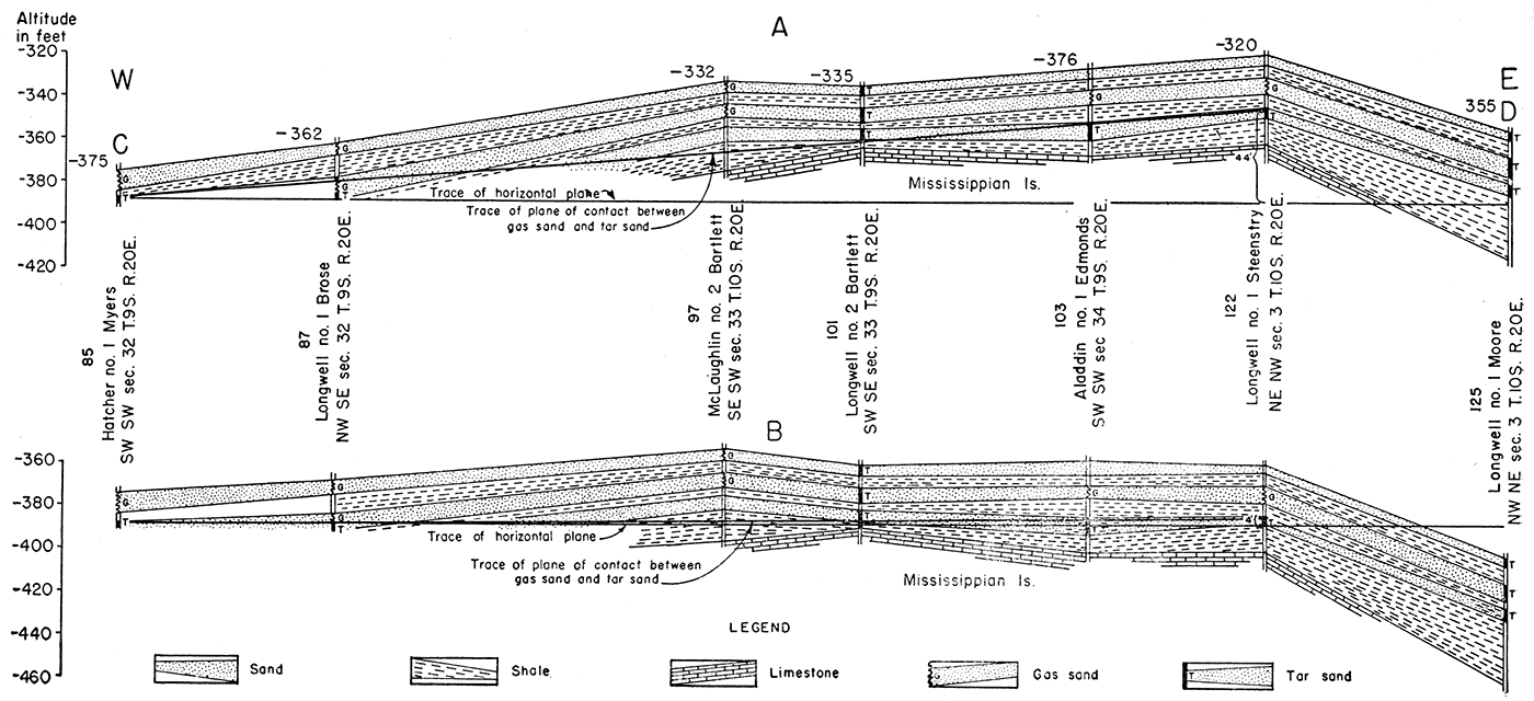
On the west side of the McLouth pool, the Hatcher and Fisk No. 1 Myers well, in the SW SW sec. 32, T. 9 S., R. 20 E., found the contact of the gas and tar sand at -388 feet. The Hatcher and Fisk No. 2 Kimmel well, in the NW NW sec. 5, T. 10 S., R. 20 E., found the contact at -387 feet. The Archie No. 1 Shrader well, in the SE SW sec. 28, T. 8 S., R. 20 E., in which some heavy oil was reported, penetrated the gas-tar contact at -373 feet.
The regional dip of the surface rocks over large areas in northeastern Kansas is approximately 15 feet per mile N. 70 W. There is, however, a convergence of Pennsylvanian strata from the center of the Forest City basin southeastward toward its margin, representing the amount of subsidence that took place during deposition. At the time of deposition of the Shawnee group, the earliest Cherokee rocks had acquired a gentle dip toward the bottom of the Forest City basin (pl. 1). In the area west of the McLouth field this convergence ranges from 2 to 5 feet per mile. An additional average dip of 3 feet per mile is assumed. Thus, although the correction required to restore the originally horizontal position in the surface rocks is only 15 feet per mile, the correction required to restore the original horizontal attitude of the McLouth sand is approximately 18 feet per mile.
The following table shows the present altitude of the gas-tar contact in the various wells noted above and their relative positions in relation to the Myers well after elimination of regional dip.
Table 5—Present altitudes of gas-tar contacts in the McLouth pool and relative altitudes of the same points compared with the Hatcher and Fisk No. 1 Myers well after elimination of regional dip.
| No. | Well | Present altitude in feet below sea level |
Altitude, in feet below sea level1 |
|---|---|---|---|
| 1 | Hatcher and Fisk No. 1 Myers, SW SW sec. 32, T. 9. S., R. 20 E. | 388 | 388 |
| 2 | Hatcher and Fisk No. 2 Kimmel, NW NW sec. 5, T. 10 S., R. 20 E. | 38.7 | 389 |
| 3 | Archie et al. No. 1 Shrader, SE SW sec. 28, T. 9 S., R. 20 E. | 3.73 | 388 |
| 4 | Longwell et al. No. 1 Steenstry, NE NW sec. 3, T. 10 S., R. 20 E. | 342 | 382 |
| 5 | Aladdin No. 1 Edmonds, SW SW sec. 34, T. 9 S., R. 20 E. | 351 | 384 |
| 1 Corrected for regional dip to compare with No. 1 Myers. | |||
It is obvious that the former position of the gas-tar contact was essentially horizontal and that the plane of contact was not altered after the development of regional dip. Cross sections A-B and C-D of figure 16 show the same relation, but slight deviations from a smooth plane of contact appear. These are believed to be caused in part by the heterogeneity of the McLouth sand which, as has been pointed out, consists of alternating zones of shale and sandstone, the porosity of which varies horizontally. It is probable that some irregularities are due to the fact that there were structural movements after the establishment of the gas-tar contact. Other deviations from a smooth plane of contact are probably due to errors in the measurement of depths which are inherent in all logs. Information provided by one well on the line of the cross section, the Archie No. 1 Brose well, in the NE SE sec. 32, T. 9 S., R. 20 E., has not been used because it presents a structural anomaly that is believed to be the result of incorrect depth records. The occurrence of tar and oil in the sands in the McLaughlin No. 2 Bartlett well is also anomalous, for the sand is high enough structurally to form part of the gas reservoir.
Relation of Tar and Water in McLouth Sand
Some irregularity of the surface of contact between the water and tar, due to irregular porosity and to alternation of sand and shale deposition, may be expected as is true of the contact between gas and tar. The plane of contact between oil and water in any pool is, of course, dependent upon the amount of gas and oil present in the anticlinal trap, and in separated pools no uniformity of the position of the plane of contact may be expected. The plane of contact, however, should be approximately uniform in individual pools.
Inasmuch as structurally low areas are avoided in oil and gas exploration, only a few wells have encountered water. They are nearly all outside the band of tar-sand wells encircling the gas areas. The distances between tar-sand wells and water wells are for the most part too great to determine the altitude of the plane of contact very sharply, but a few wells have passed through tar sand before encountering water, thus revealing the plane of contact between them locally.
In sec. 30, T. 9 S., R. 20 E., on the west side of the North McLouth pool, the contact between water and tar sandin the Hatcher and Fisk No. 1 Ray Kimmel well, in the NW SW sec. 30, as shown .in table 6, is at -439 feet; in the Jackson No. 1 Shoemaker well, in the SE SW of the same section, the contact is at -431 feet. The only well which found water in the McLouth sand on the east side of the field is the Aladdin No. 1 Corlett well, in the SW NE sec. 19, T. 10 S., R. 21 E., in which water was encountered at -323 feet. Inasmuch as no tar sand was found in this well, the water-tar contact may be assumed to be somewhat higher. The distance between the Ray Kimmel well and the Corlett well projected on the direction of regional dip is 7.7 miles. The regional dip on the McLouth sand is approximately 18 feet per mile. The correction for dip is, therefore, 138 feet. The present altitudes of the water table in these three wells and their positions relative to the Ray Kimmel well after corrections for regional dip are shown as items No. 1, 2, and 6 in table 6. The other items show the present altitudes and the altitudes corrected for the dip of the bottom of known tar or oil sands in other low wells of the field where water was not encountered.
Table 6—Present altitudes of the plane of contact between tar and water, the bottom of tar or oil sands in low wells in McLouth field, and relative altitudes of the same points compared with the water contact in the Hatcher and Fisk No. 1 Ray Kimmel well after elimination of regional dip.
| No. | Well | Remarks | Present altitude in feet below sea level |
Altitude, in feet below sea level1 |
|---|---|---|---|---|
| North McLouth pool | ||||
| 1 | Hatcher and Fisk No. 1 Ray Kimmel, NW SW sec. 30, T. 9 S., R. 20 E. | Water contact west side North McLouth pool | 439 | 439 |
| 2 | Jackson No. 1 Shoemaker, N2 SE SW sec. 30, T. 9 S., R. 20 E. | Water contact west side North McLouth pool | 431 | 435 |
| 3 | Jackson No. 1 Shrader-Haas, NW SE sec. 29, T. 9 S., R. 20 E. | Lowest tar sand, no water. South side N. McLouth pool | 464 | 480 |
| 4 | Magnolia No. 1 Mathew Woodhead, SW SW sec. 29, T. 9 S., R. 20 E. | Lowest tar sand, no water. South side N. McLouth pool | 443+ | 461+ |
| Ackerland pool | ||||
| 5 | Miller No. 1 Jeannin, NE NW sec. 7, T, 10 S., R. 21 E. | Base of oil sand, no water. East side Ackerland pool | 400 | 522 |
| 6 | Aladdin No. 1 Corlett, SW NE sec. 19, T. 10 S., R. 21 E. | Top of water sand. Local structural relations uncertain. Water contact probably higher | 323 | 461 |
| McLouth pool | ||||
| 7 | Luehring et al. No. 1 Fryhofer, NE NE sec, 7, T. 10 S., R. 20 E. | Water contact west side McLouth pool | 438 | 464 |
| 8 | Longwell No. 1 Moore, NW NE sec. 3, T. 10 S., R. 20 E. | Lowest tar sand, no water. East side McLouth pool. | 384 | 453 |
| 9 | Magnolia No. 1 Kell, NE SE sec. 4, T. 10 S., R. 20 E. | Lowest tar sand, no water. South of fault south side McLouth pool. | 392 | 459 |
| 1 Corrected for regional dip to compare with No. 1 Ray Kimmel well. | ||||
The relation of the plane of contact between tar and water in the Ray Kimmel well and the top of the water sand in the Corlett well suggests, in a general way, that the water-tar contact was established before the regional dip in the same manner that the gas-tar contact was established in the McLouth pool. The relations are inconclusive, however, for the Ray Kimmel well indicates the position of the water-tar contact on the west side of the North McLouth pool, whereas the Corlett well is on the east side of the field in a locality where the local structural features are uncertain.
No comparative figures are available to compare the relations of the water-tar contact on opposite sides of a single pool. The. Luehring No. 1 Fryhofer well, in the NE NE sec. 7, T. 10 S., R. 20 E., found the water-tar contact on the west side of the McLouth pool at -438 feet (-464 feet corrected for dip). The Longwell No. 1 Moore well, in the NW NE sec. 3, T. 10 S., R. 20 E., on the east side of the McLouth pool, did not find water but showed tar sand to a depth of -384 feet (-453 feet corrected for dip). South of the fault on the south side of the McLouth pool, the Magnolia No. 1 Kell well in the NE SE sec. 4, T. 10 S., R. 20 E., found tar sand and traces of oil to a depth of -392 feet (-459 feet corrected for dip). In accordance with the evidence at hand, the contact of water and tar sand on the west side of the McLouth pool and the depths of the lowest known tar sands on the east and south sides of the McLouth pool (regional dip eliminated) are in essential agreement and conform to the structure of the pool as it is believed to have been prior to the development of regional dip. The exact depth of the water-tar contact on the east side of the pool has not been revealed by drilling.
The tar sand in the Jackson No. 1 Shrader-Haas well, in the NW SE sec. 29, T. 9 S., R. 20 E., on the southeast side of the North McLouth pool, was drilled to a depth of -464 feet (-480 feet corrected for dip) without encountering water. This depth is far below the plane of contact of water and tar in the Hatcher well west of the North McLouth pool (-439 feet corrected for dip). It is also below the water-tar contact in the Fryhofer well west of the McLouth pool (-464 feet corrected for dip) and seems to violate the theory of an originally horizontal plane of contact between tar and water sands, inasmuch as the corrected depth of tar sand in No. 3 is below the corrected depths of the water level in Nos. 1 and 7. The Jackson No. 1 Shrader-Haas well, however, lies in a sharp syncline between the two pools. This syncline was structurally active from the time of deposition of the McLouth sand until after deposition of the Lecompton limestone. The top of the McLouth sand in this well is 120 feet below the crest of the McLouth anticline and 45 feet below the crest of the North McLouth anticline. The top of the Lecompton limestone is only 45 feet below the crest of the McLouth anticline and 25 feet below the crest of the North McLouth anticline. The anomaly, therefore, is probably the result of downward warping of the McLouth sand in the syncline after the introduction of the now desiccated oil. The Magnolia No. 1 Mathew Woodhead well, SW SW sec. 29, T. 9 S., R. 20 E. (No. 4 of table 6), which also shows a low tar-water contact, is also in the syncline in the same relative position as the Shrader well.
The water level in the McLouth sand in the Ackerland pool has not yet been determined. The lowest known oil sand in the pool was drilled in the Miller No. 1 Jeannin well, in the NE NW sec. 7, T. 10 S., R. 21 E., where oil sand was drilled to a depth of -400 feet (-522 feet corrected for dip). The altitude of the base of the sand, corrected for dip, is considerably lower than that on the west side of either the McLouth or North McLouth pools. It is also lower than the corrected altitude of the water encountered in the sand in the Corlett well and is probably controlled by local structural conditions in the Ackerland pool not yet revealed.
The different altitudes of the water on the flanks of the pools, even after corrections for dip have been applied, indicate that the water level is dependent on the accumulation of oil and gas in each pool, and also may have been modified by structural distortion after establishment of the water-tar contact.
Period of Gas and Oil Accumulation
At the time when the oil entered the sands it must have had a mobility or fluidity which permitted it to enter the pores of the sandstones. It is evident that the oil haslost this mobility because in most wells the oil is too viscous to escape from the sand into the wells and is generally reduced to a tarry matrix or a dried oil cementing the sand grains. Since the development of regional dip, the oil has not invaded the gas area on the lower side of the tilted anticline, nor has the gas displaced the oil on the upper side of the anticline. The tar must have entered the sand before the pre-Cretaceous westward tilting of the region, for the gas-tar contact conforms to the pre-Cretaceous attitude of the strata.
The time when the oil lost its mobility is uncertain. It might be assumed that the desiccation occurred prior to the development of regional dip as the position of the tar in the sand does not conform to the altered symmetry of the anticline. This hypothesis assumes that the oil, if fluid, would rearrange itself gravitationally on the opposite flanks of the anticline. It may be doubted, however, that even relatively fluid oil, having attached itself to the enclosing sand grains, would alter its position in the sand on gentle slopes. It seem improbable that, with dips no greater than 18 feet per mile, the difference in gravitational pressure on opposite sides of an anticline would overcome the surface tension by which the oil is attached to the enclosing sand grains. The desiccation of the oil may, therefore, have occurred at a date later than the regional westward tilting of the oil- and gas-bearing rocks. It may be that the oil invaded the sand and established the gas-tar and tar-water planes of contact soon after its burial, for these planes of contact are more completely restored to horizontal by the use of a dip correction of 18 feet per mile, which includes the slope of the McLouth sand into the Forest City basin, than by the use of the regional dip of 15 feet per mile of the surface rocks. The difficulty of determining the various dips with complete accuracy, however, renders this hypothesis inconclusive. The low position of the tar-water contact in the syncline between the McLouth and North McLouth pools suggests that the tar-water contact was established before the end of Pennsylvanian deformation.
The asymmetry of oil zones under anticlines in Oklahoma and in central Kansas, where the oil is generally lowest on the west side, has been attributed by some geologists to the greater accumulation of oil on the side from which the oil reached the trap. They assume that the regional dip provided the conditions essential to the migration of oil and that the oil traveled long distances up dip before coming to rest in the anticlinal trap. This hypothesis implies that there was no accumulation of oil and gas in the anticlines until after the development of regional dip which occurred after Permian and before Cretaceous time. In the McLouth field the tar and gas in the McLouth sand, whatever their original source, seem to have reached their present position before the development of regional dip. Therefore, they did not migrate long distances up the dip, and the source materials must lie at lower altitudes within an area limited by nearby synclines.
Distribution of Gas, Tar, Oil, and Water in McLouth Sand
The absence of water in the McLouth sand in the McLouth pool was early noted and has been confirmed by drilling not only in the McLouth pool but also in the North McLouth and Ackerland pools. Water is present in the McLouth sand in low wells west of the McLouth and the North McLouth pools and southeast of the Ackerland pool. The disposition of the tar sands in wells encircling the gas areas and underlying the gas in flank wells accounts for the absence of water in the field. The tar constitutes an effective seal between the gas and the water and prevents the encroachment of the water as the gas is withdrawn and the pressure in the reservoir is reduced. It has already been pointed out that gas, tar, and water show an original gravitational adjustment and a symmetrical distribution in the anticlinal traps of the field after elimination of regional dip, but it is not clear why the sand in some areas yields oil and in others is cemented with tar or dried oil.
The principal area of oil production from the McLouth sand occurs in the S2 sec. 3, T. 10 S., R. 20 E., where oil is produced from six wells on the faulted extension of a small dome on the southeast side of the McLouth anticline. The history of this fault has already been discussed. The first oil well drilled in the area south of the fault, the Longwell No. 1 Bankers Life well, in the NW SW sec. 3, T. 10 S., R. 20 E., found the top of the oil sand at -342 feet (-382 feet corrected for dip to compare with the Hatcher and Fisk No. 1 Myers well [table 7]). The highest well in this oil pool, the Longwell No. 2 Bankers Life well, in the NE SW sec. 3, found the top of the oil sand at -338 feet (-381 feet corrected for dip). Neither gas nor water has yet been encountered in the sand south of the fault.
Table 7—Relative depths to oil and gas in sec. 34, T. 9 S., R. 20 E. and sec. 3, T. 10 S., R. 20 E. north and south of fault, and depths corrected to eliminate regional dip compared with the Hatcher and Fisk No. 1 Myers well, in the SW SW sec. 32, T. 9 S., R. 20 E.
| No. | Well | Remarks | Present altitude in feet below sea level |
Altitude, in feet below sea level1 |
|---|---|---|---|---|
| 1 | Hatcher and Fisk No. 1 Myers, SW SW sec. 32, T. 9 S., R. 20 E. | Reference point | 388 | 388 |
| North of fault | ||||
| 2 | Aladdin No. 1 Edmonds, SW SW sec. 34, T. 9 S., R. 20 E. | Contact of gas and oil sand | 351 | 384 |
| 3 | Longwell No. 1 Steenstry, NE NW sec. 3, T. 10 S., R. 20 E. | Contact of gas and tar sand | 342 | 382 |
| 4 | Longwell No. 2 Steenstry, SW NW sec. 3, T. 10. S., R. 20 E. | Lowest gas sand | 335 | 374 |
| South of fault | ||||
| 5 | Longwell No. 1 Bankers Life, NW SW sec. 3, T. 10 S., R. 20 E. | Highest oil sand | 342 | 382 |
| 6 | Longwell No. 2 Bankers Life, NE SW sec. 3, T. 10 S., R. 20 E. | Highest oil sand | 338 | 381 |
| 1 Corrected for regional dip to compare with the No. 1 Myers well. | ||||
The oil occurs in the McLouth sand on the south or downthrow side of the fault. On the north or upthrow side of the fault, wells yield gas from the sand zone which terminates at the fault and abuts against black shale above the McLouth sand on the south side (pl. 4 and fig. 15). The oil, therefore, occupies a fault trap. However, as shown in table 7, the highest oil sand south of the fault before the development of regional dip was slightly below or at the same altitude as the lowest known gas sand north of the fault. The gravitational distribution of oil in the area south of the fault, therefore, conforms to that of tar and oil in other parts of the McLouth pool. Consequently, it is concluded that the oil pool south of the fault in sec. 3 is an integral part of the McLouth pool in spite of the fault that separates it from the area yielding gas.
In the North McLouth pool, two wells yield oil from the McLouth sand. The first of these to be drilled was the Anderson No. 1 May Dick well, in the SE SW sec. 17, T. 9 S., R. 20 E. This well is an edge well and the oil comes from 15 feet of sand at the top of the McLouth. It was shot with 70 quarts of nitroglycerine and has yielded 12 to 6 barrels of oil per day for a year or more. The next well north, the Anderson No. 2 Dick well, found the McLouth sand 4 feet higher. This well yielded only one-half million cubic feet of gas and no oil. The next well north, the Hatcher and Fisk No. 1 E. Edmonds well, in the SE NW sec. 17, T. 9 S., R. 20 E., was similar to the No. 1 May Dick well in that oil with some water was found 20 feet below the top of the McLouth sand. Production is less than 6 barrels of oil per day.
In addition to these areas from which oil is being produced commercially, several scattered wells have found small but not commercial amounts of oil in the McLouth sand. The Aladdin No. 1 Edmonds well, in the SW SW sec. 34, T. 9 S., R. 20 E., found gas in the top of the McLouth sand and shows of heavy oil in the lower part. The well was gauged at 2.7 million cubic feet of gas and was completed as a gas well, but oil entered and filled the hole from the oil sand as the pressure declined. Some oil (less than 100 barrels) has been taken from this well. The Longwell No. 2 Bartlett well, in the SW SE sec. 33, T. 9 S., R. 20 E. (fig. 15), also revealed traces of oil in the McLouth sand. The oil shows in this well were from the top of the McLouth sand which yields gas at this altitude in other wells in the pool. All the sand drilled in this well below the free oil at the top was saturated with tar.
The Archie No. 1 Shrader well, in the SE SW sec. 28, T. 9 S., R. 20 E., an edge well on the north flank of the McLouth pool, entered the gas sand of the McLouth at a depth of 1,442 feet, 2 feet above the gas-tar contact. A small flow of gas gauged at 396,000 cubic feet was encountered in the upper 2 feet of the sand. Oil and tar were encountered in the sand from 1,444 to 1,460 feet The well was reported to yield 7 barrels of oil per day at one time, but production has been small and intermittent.
The Hatcher and Fisk No. 1 Henry Kimmel well, in the SE SW sec. 5, T. 10 S., R. 20 E., reported a show of oil in the upper sand zone of the McLouth sand from 1,512 to 1,515 feet below the surface. This well is unusual in that gas was found in a lower sand zone below shows of oil and tar. After drilling black shale from 1,515 to 1,528 feet, gas sand was found from 1,528 to 1,543 feet. The well was completed as a gas well with an initial production of 4.5 million cubic feet per day.
The Anderson et al. No. 1 Woodhead Estate well, in the NE SW sec. 6, T. 10 S., R. 20 E., an edge well of the McLouth pool, penetrated oil sand from 1,529 to 1,582 feet immediately overlying the Mississippian. A show of oil led the operators to shoot the well with 40 quarts of nitroglycerine, but the results were unsatisfactory and the hole was plugged.
The Magnolia No. 1 Mathew Woodhead well, in the SW SW sec. 29, T. 9 S., R. 20 E., found oil in the upper sand Zone and tarry sand in. the lower sand zone of the McLouth sand on the southeastern side of the North McLouth anticline. This well was drilled in tar sand to a depth of -443 feet (-461 feet corrected for dip to compare with the tar-water contact in the Hatcher and Fisk No. 1 Ray Kimmel well [table 6]). The sand in this well was shot with 60 quarts of nitroglycerine and was reported to have had an initial production of30 barrels per day of very low gravity crude. The well has produced oil for more than a year and is still producing at the rate of 6 barrels per day. The northwest offset of this well, the Hatcher and Fisk No. 1 Black well, NE SE sec. 30, also found a show of oil in the McLouth sand but there was no production. Viscous tar has been noted in the McLouth sand cuttings of several wells, notably among others the Smythe No. 1 Federal Land Bank well, SW NE sec. 29, T. 9 S., R. 20 E., the north offset of the Mathew Woodhead well, and in the Magnolia No. 1 Kell well, NE SE sec. 4, T. 10 S., R. 20 E.
In the Ackerland pool, the Miller No. 1 Jeannin well, NE NW sec. 7, T. 10 S., R. 21 E., found oil in the lower sand zone of the McLouth sand at depths from 1,386 to 1,412 feet. The oil sand, which is 26 feet thick, lies between altitudes of -374 and -400 feet (-489 to -522 feet corrected for dip to compare with the Hatcher and Fisk No. 1 Ray Kimmel well). The sand body is very coarse angular sand and immediately overlies the Warsaw limestone of the Mississippian. It probably corresponds to the Burgess sand of other areas. The presence of Warsaw limestone in this well, which was drilled in an area of St. Louis limestone, implies an erosion channel in the top of the Mississippian and suggests that this sand may be a channel deposit. The Miller-Magnolia No. 3 Jim Bell well, in the SE SW sec. 6, T. 10 S., R. 21 E., also found oil in this sand under similar conditions. Other wells in the Ackerland pool which reached the Mississippian found only black shale or sandy shale in the position of this sandstone.
No satisfactory explanation for the anomalous and seemingly erratic occurrences of oil in the McLouth sand presents itself. Some are at points structurally low on the anticline. Others, as in the Longwell No. 2 Bartlett well, occur in structurally high parts of the sand which yield gas in adjacent wells. It seems possible that the temporary opening of joints or minor faults during the long history of differential structural growth may have permitted the entry of oil into the gas sands from deeper zones (possibly from the Mississippian or even older rocks) where accumulations of oil were under greater hydrostatic pressure than the gas in the McLouth sand. Such joints and minor faults are, however, purely hypothetical in the localities of these occurrences. Some support is given to this theory because faults are known to occur in Mississippian rocks. The occurrence of the oil pool in the McLouth sand in sec. 3, in proximity to the faulted zone, fits into such a theory but it does not explain why the oil in the Magnolia No. 1 Kell well, offsetting the Longwell No. 1 Bankers Life well and in the same position in relation to the fault zone, is too viscous to produce. The reason for the desiccation of the oil in what must once have, been a very extensive oil pool is also a mystery. Dried oil in Pennsylvanian rocks in contact with gas sands is known to occur in other parts of eastern Kansas, indicating that the conditions requisite for the desiccation are not unique to the McLouth field.
Occurrence of Oil and Gas in Mississippian Rocks
Oil and Gas at the Top of the Mississippian
The upper surface of the Mississippian which was exposed to weathering during the period of peneplanation is generally somewhat porous, but at the time of writing only small amounts of gas or oil have been found in it. The occurrence of oil and gas in the weathered zone is not determined by the pre-Pennsylvanian exposure of any particular formation. The Spergen dolomite was widely exposed on the pre-Pennsylvanian surface in the McLouth field and was thus susceptible to the development of porosity. It is, in consequence, the chief repository for the minor amounts of gas produced from the top of the Mississippian. Gas has been produced from the top of the Spergen in the McLaughlin No. 1 Ragan well in the NW NW sec. 3, T. 10 S., R. 20 E., which reported 3.7 million cubic feet of gas from the McLouth sand. After drilling through 20 feet of black shale and entering the top of the Mississippian rocks, this well made 4.5 million cubic feet, the additional gas coming from the top of the Spergen. Similarly, the MeLaughlin No. 2 Bartlett well, in the SE SW sec. 33, T. 9 S., R. 20 E., found 4.3 million cubic feet of gas in the McLouth sand which increased to 6.1 million cubic feet when drilled into the top of the Spergen. The Mosbacher No. 1 Dolman well found the McLouth sand impervious and dry, but yielded 360,000 cubic feet of gas in the top of the St. Louis limestone. This flow increased after acidization, but the water also increased. The two wells yielding gas from the Spergen are flank wells on opposite sides of the McLouth anticline. The gas seems to have been trapped in the limestone in a porous part of the weathered zone where gas accumulated as though it were a part of the McLouth sand reservoir rather than a separate zone of accumulation in the Mississippian beds.
The weathered zone at the top of the Mississippian limestones is heavily oil stained in nearly all wells that are structurally high. Shows of free oil have been noted in several wells. Two of these wells, the Young and Longwell No. 1 McLeod well, in the NW SW sec. 4, T. 10 S., R. 20 E., and the Apperson-Stark No. 1 McLaughlin well, in the S2 NW NW sec. 4, had exceptionally promising shows of free oil. These wells were acidized but the results from this zone were unsatisfactory.
Oil in the Dolomite Zone
Most of the oil in the field is produced from the porous dolomite zone in the undivided Burlington and Keokuk limestones of the Mississippian in a small dome about three-quarters of a mile in diameter in secs. 4 and 5, T. 10 S., R. 20 E., on the southwestern end of the McLouth anticline. This dome is outlined by structural contours on the overlying McLouth sand, but the structural gradients are steeper on the Mississippian rocks than on the McLouth sand. The dip on the top of the Warsaw on the northwestern flank of the dome is at the rate of 150 feet per mile; that toward the east is at the rate of 125 feet per mile. The corresponding dips in the top of the McLouth sand in the same area are at the rate of 120 and 100 feet per mile, respectively.
No commercial amounts of gas accompany the oil in the dolomite on the crest of the McLouth oil dome. Water occurs on the flanks. Table 8 shows the altitudes at which water has been encountered in flank wells of the oil pool. These wells show that the water contact in the porous dolomite zone in the McLouth Mississippian oil pool was originally at or near -519 feet. The dolomite zone on the flanks of the dome and elsewhere in the field is generally porous and charged with water.
Table 8—Altitudes at which wells encountered water in the McLouth Mississippian oil pool.
| Well | Remarks | Altitude, in feet below sea level |
|---|---|---|
| Apperson No. 1 McLeod NE SE SE sec. 5, T. 10 S., R. 20 E. | Oil and water together at top of dolomite zone | 519 |
| Aladdin No. 1 McLeod Cen. S. line SW SE NW sec. 4, T. 10 S., R. 20 E. | A few feet below the top of dolomite zone | 518± |
| Sherrod No. 2 Bower NE SW NE sec. 5, T. 10 S., R. 20 E. | Water about 16 feet-below top of dolomite zone. This well found oil in dolomite at -508 but was drilled too deep. | 523 |
| Billingsley et al. No. 1 McLaughlin Cen. E2 NW NW sec. 4, T. 10 S., R. 20 E. | Water in top of dolomite zone | 524 |
| McLaughlin No. 1 Bartlett SW SW sec. 33, T. 9 S., R. 20 E. | Water in top of dolomite zone. This well was low on the north flank of the dome. | 551 |
| Hatcher and Fisk No. 1 Henry Kimmel SE SW sec. 5, T. 10 S., R. 20 E. | Water at top of dolomite zone. This well was on the southwest flank of the dome | 532 |
| Young and Longwell No. 4 McLeod SW NE SE sec. 5, T. 10 S., R. 20 E. | Water 11 feet below top of dolomite zone. | 510 |
Water was encountered in the Young and Longwell No. 4 McLeod well at -510 feet in April, 1943, 9 feet above the anticipated water level as indicated from a comparison of other wells in the pool. Several wells higher on the structure, however, had been drawing on the reservoir for a year or more before this well was drilled. The occurrence of water at -510 feet, therefore, probably indicates water encroachment on the flank of the dome.
The pre-Pennsylvanian attitude of the Mississippian rocks is difficult to determine. Prior to peneplanation, the Mississippian rocks in the McLouth area had been given a dip of about 5 feet per mile toward the east as shown by the Mississippian thickness map (fig. 17). The subsidence that formed the Forest City basin introduced on the east side of the basin a gentle westerly dip which, although it is more toward the northwest, approximately compensated for the earlier dip in the opposite direction. Prior to the development of the pre-Cretaceous regional dip, the attitude of the Mississippian rocks of the McLouth pool was consequently again essentially horizontal. Therefore, the effect of regional dip was to tilt the Mississippian dome of the McLouth pool toward the northwest at about 18 feet per mile, a dip not greatly different from that affecting the early Pennsylvanian rocks of the area. The pool is less than one-half mile wide in an east-west direction so that the correction for regional dip does not exceed 7 or 8 feet on opposite sides of the dome. The structural gradient is so high on the east flank of the dome that correction for regional dip produces no obvious effect on the position of the crest and no marked difference in the areal position of the water line. On account of the always present possibility that small errors have been -introduced by inaccuracy in measuring depths of wells, too great reliance cannot be placed on minor variants in the depth to the top of the porous zone or depth to the oil-water contact. In any case, it seems probable in a reservoir honeycombed with coarse cavities that readjustment of the oil-water contact might occur after the development of regional dip.
The dome yielding oil from the Mississippian rocks on the southwestern end of the McLouth anticline is only one of several domes outlined by the structure of the McLouth sand on the three developed anticlines of the field (see fig. 8). This dome is the only one that has been tested for deeper production. Several wells have been drilled to the dolomite on the flanks of the other domes, but the areas on the crests that are most likely to produce from the dolomite have not been tested for pre-Pennsylvanian production because the wells that were drilled on the crests have been completed as gas wells. There seems reason to hope that some, if not all, of these domes may yield oil in the Mississippian. This probability is supported by the fact that oil occurs at so many points in the McLouth sand under conditions that suggest seepage from accumulations in deeper rocks.
Prev Page—McLouth Sand || Next Page—Production, Character, and Future
Kansas Geological Survey
Comments to webadmin@kgs.ku.edu
Web version July 2019. Original publication date June 1944.
URL=http://www.kgs.ku.edu/Publications/Bulletins/53/07_cher.html