![]()
Prev Page—Introduction || Next Page—Producing Zones
Stratigraphy
A composite stratigraphic section of rocks penetrated by drilling in the McLouth field is shown in figures 2 and 3. The key horizons used in the structure and isopachous maps are indicated by the letter K at the right of the columnar sections. The reference horizons used in well-to-well correlation and as controls for picking the key horizons are indicated by the letter R. The positions of the gas- and oil-producing zones and of the most prominent unconformities are shown by standard symbols.
Figure 2—Composite columnar section of Pennsylvanian rocks from the base of the Hertha limestone to the top of the Lecompton limestone exposed at the surface in the McLouth field. Only the more important members of the formations are shown.
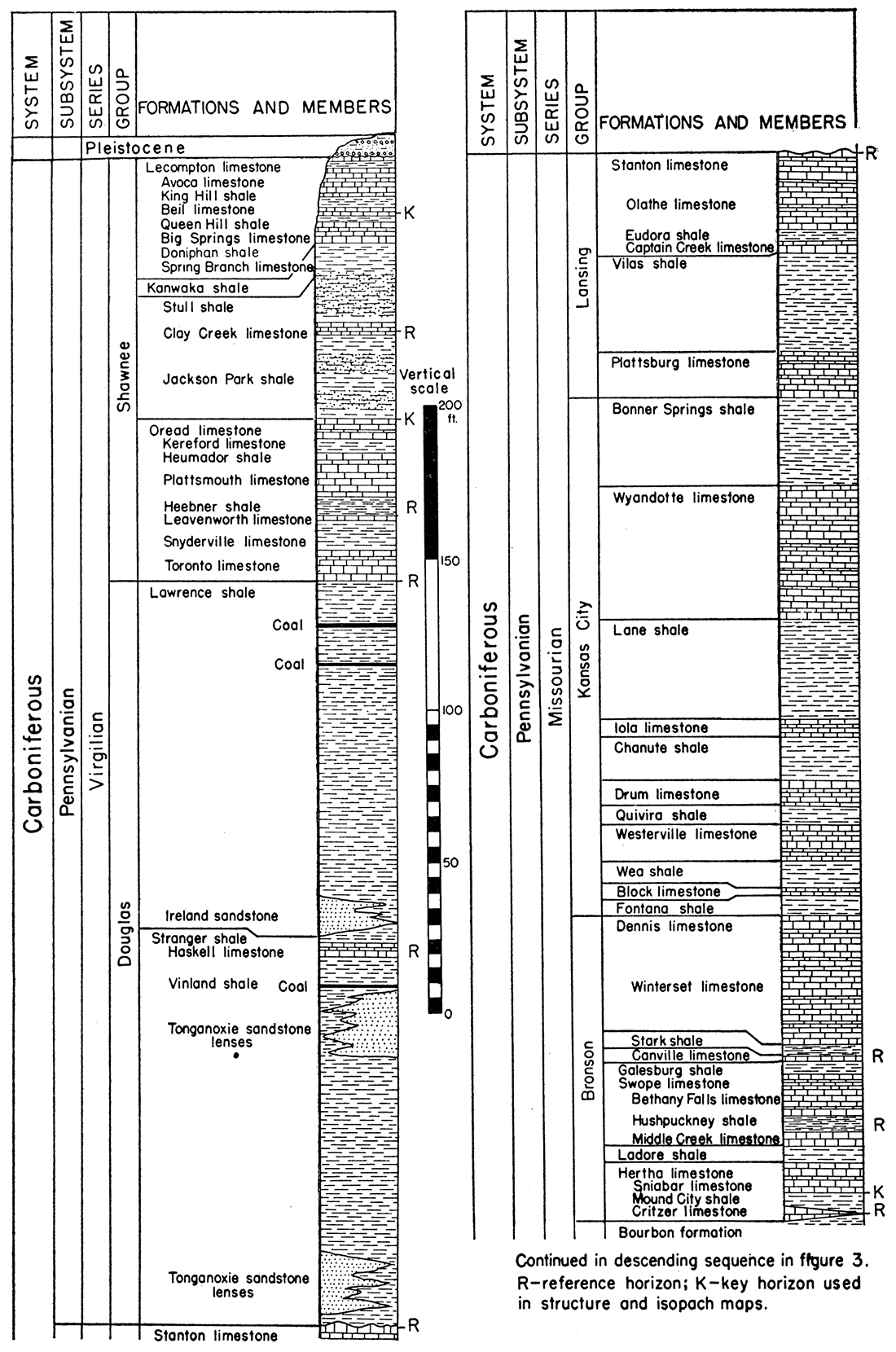
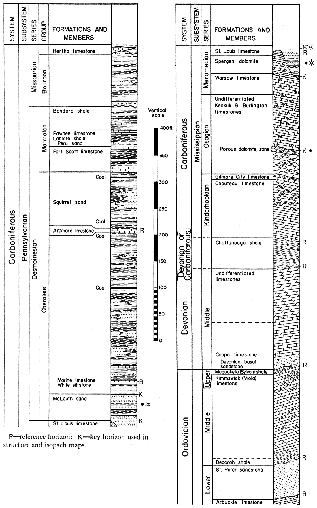
Figure 3—Composite columnar section of upper Ordovician, Devonian, Mississippian, and lower Pennsylvanian rocks in the McLouth field, Pennsylvanian section continued from figure 2.
Pennsylvanian Rocks
Pennsylvanian rocks penetrated by drilling in the McLouth field are described in detail in a report by Moore (1936) on the Pennsylvanian rocks of Kansas. The nomenclature and stratigraphic classification used in discussing Pennsylvanian stratigraphic units follow the usage of the Kansas Geological Survey.
Virgilian series—The Pennsylvanian formations that crop out in the area of the McLouth field are, in descending order, the Lecompton limestone, the Kanwaka shale, and the Oread limestone of the Shawnee group in the middle part of the Virgilian series of late Pennsylvanian age, They are, however, mantled in many areas by deposits of glacial till, clay, sand, and gravel of Pleistocene age.
The rocks of the Lecompton limestone and the Oread limestone consist chiefly of different types of limestone interstratified with shale. The Kanwaka shale consists chiefly of shale divided by the Clay Creek limestone, much of which is soft and shaly in the McLouth area. The shales above and below the Clay Creek are in part sandy. As pointed out by Moore (1936), the rocks of these and other Pennsylvanian formations were deposited in cyclic succession during the alternating advance and retreat of marine water.
The Douglas group, also a part of the Virgilian series, lies below the Shawnee group but does not crop out in the area of the McLouth field. Unlike the Shawnee group, which is partly of marine origin and contains numerous limestone beds, the Douglas group is largely of nonmarine origin and, with the exception of the marine Haskell limestone (fig. 2), does not contain much limestone. The Douglas group includes the Lawrence shale and the Stranger formation and consists predominantly of shale, sandy shale, sandstone, siltstone, and massive clay beds; there are also minor beds of coal, underclay, clay ironstone, and nonfossiliferous and probably nonmarine sandy limestone. The Douglas group contains beds of channel sandstone (fig. 2), including the Ireland sandstone in the lower part of the Lawrence shale and sandstone developed at variable positions in the Stranger formation, commonly referred to as the Tonganoxie sandstone. The beds of the Douglas group show marked vertical lithologic variations and few of the beds are laterally persistent. The Haskell limestone was deposited upon an irregular surface and is not a trustworthy datum bed for the mapping of structure.
Missourian series—The Douglas group is underlain by the Lansing, Kansas City, and Bronson groups, which are part of the Missourian series and consist of alternating beds of limestone and shale (fig. 2). The lowest persistent limestone of the Bronson group is the Hertha limestone, the base of which is used as a key horizon for structure contour mapping. It is described later under the heading entitled Base of Hertha limestone. That part of the Missourian series below the Hertha limestone is the Bourbon group. It consists largely of silty to sandy shale; locally, at the base, there is a thick sandstone deposit, and in places there are extensive sandstone beds in the middle and upper parts of this group.
Desmoinesian series—The Desmoinesian series, which lies below the Missourian, consists of an upper part, the Marmaton group, and a lower part, the Cherokee group. The Marmaton group consists chiefly of alternating beds of shale and limestone and also contains persistent thin coal beds and sandstone beds. The sandstone beds of the Marmaton, known loosely as "Peru sand," yield gas in many places in eastern Kansas but are unproductive in the McLouth field. The limestones of this group are thin in the McLouth area and are not consistently logged by all drillers. They cannot be differentiated where samples have been taken at long intervals, and consequently they are unsatisfactory for correlation in the McLouth field. The most prominent formation of the Marmaton, the Fort Scott limestone, is a good datum bed in most places in Kansas, but it is thin in the McLouth field and cannot be identified in all wells. The Cherokee shale (fig. 3) includes strata of diverse lithologic types from the base of the Fort Scott limestone of the Marmaton group down to the base of the Pennsylvanian. Within the Cherokee there are cyclic successions of sandstone, shale, coal, and in some places thin limestone beds; these successions are not as well developed as those in the Shawnee, Lansing, Kansas City, and Bronson groups and differ in character from those beds. The predominant type of rock in this formation is shale, of which there are many varieties including clay shale, silty micaceous shale, and sandy shale. Black carbonaceous shale is common. There are also beds of massive clay, sandstone, and siltstone, and thin beds of coal, clay ironstone, and limestone. The sandstone beds lack lateral persistence. Some grade laterally into sandy shale; others fill ancient channels or perhaps, as in other parts of eastern Kansas, represent offshore bars (Bass, 1936). A zone of discontinuous sandstone beds in the upper part of the Cherokee, 50 to 100 feet below the base of the Fort Scott limestone, is known to gas operators as the "Squirrel sand." It has yielded gas in many fields in eastern Kansas, but is not productive in the McLouth field. With the exception of certain of the limestone beds, the group is dominantly of nonmarine origin. The most prominent limestone, the Ardmore limestone (fig. 3) which occurs in the upper middle part of the .Cherokee, probably does not exceed 5 feet in thickness. The Ardmore should constitute a valuable reference or datum bed. However, it is not always logged by drillers, and samples from this part of the stratigraphic section are taken at such long intervals in many wells that the exact depth of the Ardmore is locally uncertain even when material from it is recognized in the samples.
The McLouth sand, a variable sequence of shale and sandstone which constitutes the basal part of the Cherokee group and overlies Mississippian rocks, is described in detail in a subsequent part of the report. This sand constitutes the gas- and oil-producing zone of the Pennsylvanian rocks in the McLouth field.
Pennsylvanian Datum Beds
The Pennsylvanian beds that have proved most useful as datum beds in the study of structure are described below. The term "key horizon" is used to refer to datum beds which were used in the preparation of structure and thickness maps. Reference beds are those that have been useful in confirming the identification of key beds but which have not been of direct use in structural studies.
Top of Oread limestone—The uppermost key horizon used in structure contour mapping in the McLouth field is the top of the Oread limestone formation. This horizon (fig. 2), at the contact between the Oread limestone and the overlying Jackson Park shale, is recognized by drillers and is easily identified by means of sample studies.
The Kereford limestone member, the topmost member of the Oread (fig. 2), is an impure, very fine-grained, fossiliferous limestone, with very light brownish-gray coloration. Its thickness is variable within the field and ranges from 5 to 10 feet. Fusulinids, crinoid stem plates, and molluscan remains are abundant. The insoluble residue, ranging up to 11 percent by weight, consists primarily of silt composed of quartz and mica. Locally, the Kereford member contains oolites which stand out as dark-gray, patches on the surfaces of rock fragments in well cuttings.
The Jackson Park shale (fig. 2) overlies the Kereford member of the Oread limestone and is generally 25 to 30 feet in thickness. It consists of calcareous and carbonaceous fine sandstone and siltstone composed dominantly of quartz and mica grains cemented by calcite. The rock is light buff-gray as seen under the binocular microscope. Fossil remains consist of abundant carbonized fragments of land plants.
In addition to the above-described rocks, there are several reference beds used in well-to-well correlation and as controls for determining this key horizon. The Clay Creek limestone which is 2 to 4 feet thick and overlies the Jackson Park shale is represented in most drillers logs. The base of this fusulinid-bearing, brownish-gray, fine-grained argillaceous limestone is 25 to 30 feet above the top of the Oread limestone. Another important reference bed is the Heebner shale member of the Oread formation. This black, carbonaceous, hard and very fissile shale, logged as "black slate" in many records, averages less than 5 feet in thickness. Its top lies about 30 feet below the top of the Oread. The Toronto limestone member, the lowermost member of the Oread formation, averages 8 feet in thickness and is light buff-gray in color and fine- to medium-grained. It is rather impure fossiliferous limestone, containing a residue of silt and very fine sand composed of quartz and a minor amount of mica. The base of this member commonly is 55 to 60 feet below the top of the Oread.
Base of Hertha limestone—The second key horizon in the McLouth field, the base of the Hertha limestone (fig. 2), ranges from 630 to 680 feet below the top of the Oread limestone, but in most wells is 650 to 670 feet below the top of the Oread. As described by Jewett (1932, p. 100) and as recognized by the Kansas Geological Survey, the Hertha along its belt of outcrop in Kansas and Missouri consists of two limestone members separated by a shale which averages 5 feet in thickness. The upper limestone member, the Sniabar limestone, is the most persistent and the most distinctive lithologically of the two members; its base represents a good key horizon. The lower member, the Critzer limestone, in the subsurface is highly variable and is not laterally persistent. The base of the Hertha as used in this report is at the base of the Sniabar limestone member of the revised classification. The Critzer is thin and variable and occurs only locally. The writers have retained the name "Hertha limestone" in its original sense for this key horizon inasmuch as it is commonly so termed by drillers and operators. In wells in which the Critzer limestone is found, drillers confuse the base of Hertha, as here used, with the base of the Critzer.
The Sniabar member of the Hertha limestone averages 10 feet in thickness and varies considerably in lithology. Characteristically, it is a nearly white to light-buff, impure, fine- to medium-grained dolomitic limestone; the impurities, as shown by insoluble residues, consist mostly of silt and very fine sand composed of quartz and mica. The rock varies laterally from highly dolomitic to highly calcitic. Fossils are not abundant, but samples from several wells contain a few crinoid remains and fragments of corals and brachiopods. Coarse oolite phases were noted in samples from several wells. In some places the oolites have been in part removed by solution, leaving a highly porous water-bearing rock. In a few samples the oolites have been dolomitized.
The Sniabar member of the Hertha limestone is underlain by the Mound City shale (fig. 2), which varies greatly in lithology in different parts of the field and averages 5 feet in thickness. Commonly it is a light- to dark-gray clay shale, but in several wells the Sniabar limestone is underlain by a shaly carbonaceous quartz siltstone. The Critzer limestone member underlies the Mound City shale and, although not everywhere present, it is a valuable reference bed. In the McLouth field the Critzer is thin, ranging to 3 or 4 feet in thickness where present, and is a hard, sublithographic, dolomitic limestone. It commonly is brownish-gray in color and is very impure, yielding a large residue of quartzose and micaceous silt.
There are two important reference beds above the Hertha limestone. The Hushpuckney shale, the base of which is about 20 feet above the base of the Hertha limestone, is recorded in most drillers logs. This shale bed is 3 to 4 feet in thickness; the lower part consists of black fissile shale and the upper part is bluish-gray clay shale. The Stark shale (fig. 2) lies 20 to 25 feet above the Hushpuckney shale and also is valuable in well-to-well correlation. It is 2 to 4 feet in thickness and is for the most part black and fissile.
Top of McLouth sand—The top of the McLouth sand constitutes a reliable key horizon in the lower part of the Cherokee (fig. 3). The lithology of the McLouth sand is described in a subsequent part of the present report. A persistent white siltstone bed a short distance above the McLouth sand is generally recognized by drillers and provides a valuable marker indicating the proximity of the top of the sand. It is logged by drillers as "white shale" and its top is 15 to 25 feet, usually 20 feet, above the top of the McLouth sand. The bed averages less than 4 feet in thickness and consists of nearly white to very light buff-gray micaceous quartz siltstone which commonly contains reddish-brown siderite spherulites ("pellets") averaging 0.5 mm in mean diameter. The siltstone is overlain by an even more persistent reference bed, a medium to very dark-gray fossiliferous argillaceous limestone (fig. 3) which is recorded by drillers in some logs as "shell limestone." It leaves a large insoluble residue of dark argillaceous bituminous material and is easily overlooked because of its very dark color. The thickness of this limestone bed cannot be determined accurately from drillers logs and from examination of samples; it is probably only 1 to 2 feet thick in general, but in a few wells it is 4 feet thick. The limestone contains crinoid remains (mostly stem plates) and brachiopods. Inasmuch as the Cherokee shale shows indications of nonmarine origin, this limestone represents only a brief invasion of marine waters in a region of dominantly continental sedimentation.
The interval from the base of the white siltstone reference bed down to the top of the McLouth sand consists, for the most part, of dark-gray to black carbonaceous shale; locally, there are beds of massive clay as well as black shale and traces of coal and clay ironstone.
The top of the McLouth sand is determined in the samples by the first appearance of sand below the above-described reference beds. This key horizon is generally about 20 feet below the top of the white siltstone or below the base of the marine limestone, and one or the other of these reference beds; usually both, is nearly always represented in the drillers logs or cable-tool cuttings. Samples from some of the wells indicate that in places a thin layer of nearly white dense quartzitic sandstone lies above the more porous sandstone of the top of the McLouth; this silica-cemented nonporous sandstone is erratic in its position and occurrence and is not considered as part of the McLouth sand.
Water-bearing Zones in Pennsylvanian Rocks
Several water-bearing zones are encountered in drilling the Pennsylvanian rocks in the field. Zones that yield water in sufficiently large amounts to interfere with drilling operations in some wells are dry in others, and the volume of water entering the wells from most of the zones varies materially from well to well. The Jackson Park sandy shale member (fig. 2) of the Kanwaka formation (Shawnee group) has yielded a few barrels of water per hour in several wells. The Stranger formation of the Douglas group has a sandstone phase, commonly known as the Tonganoxie sandstone (fig. 2), which is highly variable in position and thickness. Ordinarily this sandstone phase is developed in the upper part of the Stranger, where it is separated from the Haskell limestone by a few feet of Vinland shale. This sandstone yields several barrels of water per hour in many wells in the field. In several wells the sandstone occurs in the lower part of the Stranger, just above the Stanton limestone, and is separated from the upper sandstone by the brownish siltstone typical of the Stranger formation. This lower bed yields from a few barrels to a hole full of water.
Several minor water-bearing zones are present in the limestone and shale section of the Bronson, Kansas City, and Lansing groups. Drillers logs of individual wells commonly show a few barrels of water per hour from one or more of these zones and in occasional wells a hole full of water. Several wells have encountered water at the Eudora shale in the Lansing group approximately 30 feet below the top of the Stanton limestone. Small amounts of water, probably from the upper part of the Wyandotte limestone of the Kansas City group, have been reported in a few wells. A more persistent water-bearing zone occurs near the base of the Kansas City group. A few drillers logs show water in the Bronson group at the depth of the Hushpuckney shale and also below the Hertha limestone.
Sandstone in the Bourbon group yields water in a few wells. Locally the presence of water in one or more sandstone beds ("Peru" sand) in the Marmaton group is indicated on logs. The Cherokee shale contains several water-bearing sands, flow from which has hampered drilling operations in some wells. A flow of water from a sand zone (Squirrel sand) in the upper part of the Cherokee, between the base of the Fort Scott limestone and the Ardmore limestone, has resulted in a hole full of water in a few wells. Between the Ardmore limestone and the top of the McLouth sand in the Cherokee, sporadic water sands have yielded from a few barrels per hour to a hole full of water. The occurrence of water in the McLouth sand in the McLouth field is rare and is discussed in another chapter.
Log of Pennsylvanian Well
The following excellent log of a well drilled by Dave Wilson, contractor, is representative of the Pennsylvanian rocks in the McLouth field. Nearly all the named units of the Pennsylvanian are identifiable in this log.
Table 1—Log of McLaughlin & Sons No. 2 Dark well, SE NE sec. 5, T. 10 S., R. 20 E., Jefferson county, Kansas. (Altitude above sea level at mouth of well, 1,114 feet. Drilling began July 23, 1940; completed August 7, 1940. Production, 3 million cu. ft. per day.)
| Thickness (feet) |
Depth (feet) |
||||||
|---|---|---|---|---|---|---|---|
| Quaternary system | |||||||
| Pleistocene series | |||||||
| Soil and yellow clay | 10 | 10 | |||||
| Quick sand | 8 | 18 | |||||
| Blue shale | 7 | 25 | |||||
| Quick sand | 9 | 34 | |||||
| Carboniferous system | |||||||
| Pennsylvanian subsystem | |||||||
| Virgilian series | |||||||
| Shawnee group | |||||||
| Lecompton limestone | |||||||
| Limestone | 6 | 40 | |||||
| Shale | 3 | 43 | |||||
| Limestone | 9 | 52 | |||||
| Kanwaka shale | |||||||
| Shale | 26 | 78 | |||||
| Limestone (Clay Creek limestone member) | 3 | 81 | |||||
| Dark shale | 13 | 94 | |||||
| Sand | 10 | 104 | |||||
| Dark shale | 7 | 111 | |||||
| Oread limestone | |||||||
| Limestone | 7 | 118 | |||||
| Shale | 3 | 121 | |||||
| Limestone | 19 | 140 | |||||
| Black slate (Heebner shale member) | 4 | 144 | |||||
| Limestone | 3 | 147 | |||||
| Dark shale | 5 | 152 | |||||
| Light shale | 6 | 158 | |||||
| Limestone | 7 | 165 | |||||
| Missourian series | |||||||
| Douglas group | |||||||
| Lawrence shale | |||||||
| Shale | 40 | 205 | |||||
| Sandstone | 7 | 212 | |||||
| Shale | 78 | 290 | |||||
| Haskell limestone | |||||||
| Limestone | 3 | 293 | |||||
| Stranger formation | |||||||
| Light shale | 17 | 310 | |||||
| Sandstone | 5 | 315 | |||||
| Sandy shale | 65 | 380 | |||||
| Dark shale | 20 | 400 | |||||
| Gray shale | 35 | 435 | |||||
| Lansing group | |||||||
| Stanton limestone | |||||||
| Sandy lime, water | 9 | 444 | |||||
| Light shale | 2 | 446 | |||||
| Limestone | 12 | 458 | |||||
| Dark shale | 4 | 462 | |||||
| Limestone | 4 | 466 | |||||
| Viola shale | |||||||
| Dark sandy shale | 19 | 485 | |||||
| Plattsburg limestone | |||||||
| Limestone | 19 | 504 | |||||
| Kansas City group | |||||||
| Bonner Springs shale | |||||||
| Black shale | 2 | 506 | |||||
| Red shale | 4 | 510 | |||||
| Shale | 22 | 532 | |||||
| Wyandotte limestone | |||||||
| Limestone | 10 | 542 | |||||
| Light shale | 28 | 570 | |||||
| Limestone | 13 | 583 | |||||
| Lane shale | |||||||
| Light shale | 19 | 602 | |||||
| Iola limestone | |||||||
| Limestone | 6 | 608 | |||||
| Shale | 2 | 610 | |||||
| Limestone | 2 | 612 | |||||
| Shale | 6 | 618 | |||||
| Limestone | 8 | 626 | |||||
| Chanute and Quivira shale (Drum limestone not identified) | |||||||
| Shale | 25 | 651 | |||||
| Westerville limestone | |||||||
| Limestone | 3 | 654 | |||||
| Wea shale | |||||||
| Shale | 15 | 669 | |||||
| Block limestone | |||||||
| Limestone | 5 | 674 | |||||
| Fontana shale | |||||||
| Dark shale | 5 | 679 | |||||
| Bronson group | |||||||
| Dennis limestone | |||||||
| Limestone (Winterset limestone member) | 32 | 711 | |||||
| Black shale (Stark shale member) | 4 | 715 | |||||
| Swope limestone | |||||||
| Limestone (Bethany Falls limestone member) (water) | 30 | 745 | |||||
| Black shale (Hushpuckney shale member) | 5 | 750 | |||||
| Limestone | 3 | 753 | |||||
| Dark shale | 3 | 756 | |||||
| Hertha limestone | |||||||
| Limestone (Sniabar) | 12 | 768 | |||||
| Dark shale | 7 | 775 | |||||
| Sandy limestone (Critzer) | 5 | 780 | |||||
| Bourbon group | |||||||
| Sandy shale | 92 | 872 | |||||
| Sandstone | 7 | 879 | |||||
| Desmoinesian series | |||||||
| Marmaton group (undifferentiated) | |||||||
| Red shale | 4 | 883 | |||||
| Limestone | 4 | 887 | |||||
| Black shale | 4 | 891 | |||||
| Limestone | 1 | 892 | |||||
| Black shale | 4 | 896 | |||||
| Shale | 17 | 913 | |||||
| Limestone | 6 | 919 | |||||
| Shale | 14 | 933 | |||||
| Sandy limestone | 5 | 938 | |||||
| Light shale | 7 | 945 | |||||
| Dark shale | 10 | 955 | |||||
| Limestone | 2 | 957 | |||||
| Dark shale | 11 | 968 | |||||
| Limestone | 4 | 972 | |||||
| Shale | 20 | 992 | |||||
| Sandy limestone | 5 | 997 | |||||
| Light sandy shale | 4 | 1,001 | |||||
| Limestone | 2 | 1,003 | |||||
| Cherokee group | |||||||
| Light shale | 6 | 1,009 | |||||
| Sandstone | 21 | 1,030 | |||||
| Dark shale | 70 | 1,100 | |||||
| Light shale | 24 | 1,124 | |||||
| Limestone (Ardmore limestone member) | 2 | 1,126 | |||||
| Shale | 44 | 1,170 | |||||
| White shale | 15 | 1,185 | |||||
| Red shale | 3 | 1,188 | |||||
| Blue shale | 47 | 1,235 | |||||
| Sandstone (a little water) | 12 | 1,247 | |||||
| Red shale | 8 | 1,255 | |||||
| Dark shale | 17 | 1,272 | |||||
| Sandstone | 8 | 1,280 | |||||
| Dark shale | 17 | 1,297 | |||||
| Shale | 17 | 1,314 | |||||
| Sandstone | 7 | 1,321 | |||||
| Sandy shale | 8 | 1,329 | |||||
| Dark sandy shale | 21 | 1,350 | |||||
| Light sandy shale | 5 | 1,355 | |||||
| Black shale | 14 | 1,369 | |||||
| Sandstone | 9 | 1,378 | |||||
| Black shale | 8 | 1,386 | |||||
| Light shale | 4 | 1,390 | |||||
| Black shale | 15 | 1,405 | |||||
| Black sandy shale | 5 | 1,410 | |||||
| Black shale | 5 | 1,415 | |||||
| Light shale | 5 | 1,420 | |||||
| Dark shale | 11 | 1,431 | |||||
| McLouth sand | |||||||
| Sandstone (gas) | 15 | 1,446 | |||||
| Shale and sandstone (increase of gas) | 6 | 1,452 | |||||
| Shale | 14 | 1,466 | |||||
| Mississippian subsystem | |||||||
| Meramec group | |||||||
| Spergen limestone | |||||||
| Silty dolomite | 4 | 1,470 T.D. | |||||
Mississippian Rocks
The Mississippian limestones as shown in the columnar section (fig. 3) underlie the Pennsylvanian from which they are separated by an angular unconformity. During the time interval represented by the unconformity, the Mississippian rocks were gently folded and peneplaned. Peneplanation in northeastern Kansas, however, was less complete than in central Kansas and some broad valleys of low relief are revealed by plotting the thickness of the formations above and below this surface. Partly on account of the folding and beveling of the limestones and to a minor degree on account of local erosional relief of the surface, different Mississippian formations underlie the Pennsylvanian in different parts of northeastern Kansas. Rocks of St. Louis, Spergen, and Warsaw limestone have been identified at the top of the Mississippian in the McLouth field (fig. 17).
The Ste. Genevieve limestone is the youngest Mississippian formation represented in this part of Kansas. It is preserved only in structurally low areas where only a part of the formation survives. The Ste. Genevieve consists of fine well-sorted calcareous sand and finely sandy limestone. Some of the beds are oolitic or pseudo-oolitic. The Ste. Genevieve formation seems to overlie the St. Louis limestone conformably. It has been identified with certainty only in areas north and east of the field.
The St. Louis limestone characteristically consists of dense gray lithographic or sublithographic limestone, although some wells reveal thin interstratified beds of semigranular fossiliferous limestone. The St. Louis limestone is noncherty and most samples leave no insoluble residue when treated with acid. Some samples, however, contain a little fine silt and a few enclosed sand grains at the base.
The St. Louis limestone was eroded from the central part of the McLouth field but is preserved on the east side of the field (see fig. 14) where it is the youngest local Mississippian formation that survived the period of peneplanation. Several wells west of the field (Sifers No. 1 Leonhard well, in the SE SW sec. 9, T. 10 S., R. 19 E., and others) reveal St. Louis limestone in areas surrounded by wells that penetrated Spergen limestone at the top of the Mississippian. The St. Louis limestone has survived in this area because it caps low pre-Pennsylvanian hills.
The St. Louis limestone has a maximum observed thickness of 36 feet in the McLouth field. It is unconformable below the Pennsylvanian except where the Ste. Genevieve intervenes. It seems to be conformable with the Spergen, but abnormal thicknesses of the Spergen in a few wells and the occasional occurrence of grains of sand in basal St. Louis beds suggest a disconformity.
The Spergen dolomite is the formation generally encountered on the pre-Pennsylvanian surface of the McLouth field. It consists of gray silty dolomite with minor amounts of chert. In some localities the Spergen is greenish-gray and contains so much silt and so many sponge spicules that the insoluble residues form a loosely coherent mass. In some places the dolomite is interstratified with semigranular microfossiliferous limestone in which the foraminifer Endothyra baileyi, a characteristic Spergen fossil, has been observed.
The insoluble residues of the Spergen generally are less than 5 percent chert but the enclosed silt and sponge spicules in some samples amount to 25 percent. The chert includes opaque gray, brown, or salmon-colored chalcedonic crusts and semiopaque and opaque microfossiliferous chert like that in the underlying Warsaw. Some of the chert in the insoluble residues is pitted with minute casts from which fragments of calcareous micro-organisms have been leached.
The Spergen dolomite rarely exceeds 30 or 35 feet in thickness, and where the St. Louis limestone has been eroded the thickness is generally less. In a few wells, the Spergen is 50 feet or more thick and rests upon the Warsaw limestone with which it seems to be conformable. This local thickening of the Spergen, which is greater than where it is overlain by the St. Louis, suggests that there may be an obscure disconformity between the Spergen and St. Louis formations. Nothing has been observed to indicate that there is an unconformity between the Spergen and the underlying Warsaw limestone.
The Warsaw limestone consists essentially of cherty semigranular fossiliferous limestone. In some zones, fossil fragments of crystalline limestone are incorporated in a matrix of sucrose dolomite that can be traced short distances from well to well. The insoluble residues consist mainly of gray chert crowded with silicified remains of broken microfossils of different sizes. The amount of insoluble residue in the samples ranges from 10 to 50 percent by volume. The base of the fossiliferous cherty limestone is regarded as the base of the Warsaw formation. The Warsaw limestone, which normally is overlain by the Spergen limestone, had been exposed by channeling in a few places on the flanks of the field before the Mississippian rocks were covered by Pennsylvanian rocks.
The average thickness of the Warsaw limestone is 35 feet but there is some variation. Thicknesses of 10 to 15 feet greater or less than the average have been observed. Except for these variations in thickness, no evidence has been noted indicating unconformities between the Warsaw and the overlying and underlying formations. In other parts of Kansas, however, an important disconformity exists below the Warsaw, but this break in sedimentation is not apparent in the McLouth field.
Undifferentiated Keokuk and Burlington limestones underlie the Warsaw limestone. In this part of Kansas these formations consist of two members which are distinguishable lithologically, but these members are not known to represent the respective formations. The upper member is predominantly limestone; the lower member is predominantly dolomite.
The top of the upper or limestone member is placed arbitrarily at the top of a gray sparsely cherty bed of sucrose dolomite, 2 to 10 feet thick. This bed is lithologically different from both Warsaw and Keokuk and might be included in either. The small insoluble residues of this bed consist of crumbs of spongy spicular silt similar to some insoluble residues of the Spergen limestone. The remainder of the upper member of the undivided Keokuk and Burlington is mainly semigranular fossiliferous limestone, but some samples consist of dolomite in which broken calcareous fossils are distributed. The dolomitic zones can be traced locally from well to well but have no extended continuity.
The amount of chert in the upper member is variable and constitutes 2 to 60 percent of the samples. The chert in the upper part of this member is gray, dense, opaque, and massive. Much of it has a microscopically grainy texture which aids in identifying the upper member of the Burlington and Keokuk. In the lower part of the limestone member there is much microfossiliferous chert which is superficially similar to that in the Warsaw but differs in that fragments of fossils have been replaced by vitreous translucent chalcedony or by quartz. Some zones are nearly free of chert and serve as convenient reference beds within limited areas. The thickness of the limestone member is 95 feet.
The lower or dolomitic member of the undivided Keokuk and Burlington limestones is composed of coarsely sucrose very cherty dolomite which contains coarse cavities at the top. A core taken from this zone in the Apperson No. 1 Bower well, in the SE SE NE sec. 5, T. 10 S., R. 20 E., shows that the openings are due to leaching of crinoid stems and fragments of other fossils originally incorporated in a coarsely sucrose dolomite matrix. The leaching seems to have been the result of exposure and weathering and, therefore, indicates an unconformity, but no erosional relief has been detected in the McLouth area. This porous zone is the reservoir rock of most of the oil from the McLouth field. It is recognizable in most wells in northeastern Kansas where its regional porosity is shown by the fact that it yields large amounts of water.
The entire dolomitic member of the undivided Burlington and Keokuk beds has been drilled in only six wells in the McLouth field. In these wells the dolomite below the porous zone at the top is dense and impervious. The insoluble residues are gray, opaque to semiopaque, massive chert and make up 25 to 85 percent of the samples. The lower or dolomitic member is 55 to 60 feet thick.
The total thickness of the undivided Keokuk and Burlington limestones is about 150 feet. No marked local variation of thickness was noted. These limestones unconformably overlie the Gilmore City limestone, but the Gilmore City is cut out in some places and locally the undivided Keokuk and Burlington rests unconformably on the Chouteau limestone.
The Gilmore City limestone is a gray to white semigranular fossiliferous limestone. In some zones fragments of fossils are imbedded in a soft calcareous matrix which is easily pulverized in drilling. The fine-grained fragments are lost in washing so that samples of Gilmore City limestone from wells drilled by cable tools are small. Some beds of the Gilmore City contain irregularly shaped and sparsely distributed oolites, some of which are black. Oolitic beds, although characteristic, are a subordinate part of the formation. Insoluble residues are generally less than 2 percent by volume. The Gilmore City in the McLouth field is about 25 feet thick, but it is absent in some places in the surrounding region. It lies unconformably below the Burlington and unconformably above the Chouteau limestone. In some places in northeastern Kansas it replaces the upper member of the Chouteau.
The Chouteau limestone consists of three members: a noncherty or sparsely cherty buff to brown sucrose dolomite at the top, as much as 20 feet thick; a very cherty impure dolomite about 70 feet thick in the middle; and a sparsely cherty limestone member about 40 feet thick at the base. The Gilmore City limestone has replaced part or all of the eroded upper member of the Chouteau limestone in the McLouth field so that this member has a variable thickness and may be absent locally. The dolomite of the middle member, like the top, is sucrose, generally buff or brown, but it contains ash-gray, rough or grainy chert which is uniquely characteristic of the Chouteau. Insoluble residues amount to as much as 75 percent of some samples, although the average is probably less than 40 percent. The limestones of the basal member are, for the most part, noncherty and semigranular, but there is some argillaceous and sublithographic limestone at the bottom. Oolitic limestone has been noted at the bottom of the Chouteau in one well near the McLouth field (Continental No. 1 Berridge well in sec. 8, T. 9 S., R. 17 E.). The total thickness of the Chouteau formation is about 120 feet in the McLouth field. It lies unconformably on the Chattanooga shale, but the unconformity is not obvious locally.
Cave Deposits in Mississippian Rocks
Rocks of probable early Pennsylvanian age have been found enclosed in upper Mississippian rocks in at least half of the deep wells in the McLouth field and in many other wells in northeastern Kansas. The rocks consist chiefly of fine fragments and grains of black, dark, and gray shale deposited in a matrix of dark clay or black silty clay. The shale fragments include many types of black, micaceous, silty, and carbonaceous shale most of which have their counterparts in deposits of the Cherokee group. Occasional flakes of carbonized wood have been recognized. Grains of coarse and fine sand sparingly incorporated in dark clay, although rare, have been observed in the cuttings of some wells. Pitted and weathered chert embedded in a clay matrix is also present locally. Some of the samples from wells in which the Pennsylvanian rocks have been cased off consist largely of laminated black and dark clay shale and dark finely micaceous shale which is indistinguishable from Cherokee shale. Pyrite in varying amount is common. Among the more striking constituents present in minor amounts are thinly disseminated grains and coarse pellets of green clay resembling pale glauconite and minute aggregates of fine opaque white powdery silica. The siliceous aggregates are thinly distributed in the black silty shale. This material resembles white silt, but its characteristics suggest. incipient and incompletely coalesced chert. These siliceous aggregates and the green clay particles, although thinly distributed and not everywhere present, are the most striking elements of the clastic shale (pl. 7).
The cuttings from the upper part of the cave deposit in two wells consisted almost entirely of spongy black pyrite. In one of these (Apperson-Stark et al. No. 1 McLaughlin well, in SW NW NW sec. 4, T. 10 S., R. 20 E.) about 15 feet of black oil-stained spongy pyrite occurs at the top of the cave deposit. This is underlain by black carbonaceous shale with scattered fragments of carbonized wood beneath which is the more typical clastic dark silty shale with disseminated grains of pale-green clay. The lower 3 feet of the deposit consists mainly of pitted and weathered chert which is seemingly a residual deposit in clay. The shale deposit in this well is 35 feet thick and is overlain by 40 feet of Spergen and Warsaw limestones. In most wells, however, the shale deposits consist chiefly of clastic silty shale less than 15 feet thick. All the known cave deposits occur in the upper part of the Mississippian above the porous dolomite zone of the undivided Burlington and Keokuk limestones, which is water bearing throughout most of northeastern Kansas. Only six wells in the field have been drilled below the dolomite zone. None of these wells nor wells elsewhere in northeastern Kansas reveal cave deposits in the lower Mississippian, although they may occur.
It was at first believed that these black shales were cavings from the lower Pennsylvanian, in spite of the fact that casing was reported to have been set at the top of the Mississippian. It was soon recognized, however, that their lithology is somewhat unique and that the deposits include fragments of rocks not observed in the overlying Pennsylvanian. Other attempts to explain these deposits include the hypotheses (1) that they represent accumulations of Cherokee deposits in open fissures or along fault breccias; (2) that they are intraformational deposits in the Mississippian; or (3) that they are deposits filling solution chambers in the Mississippian limestone.
One of the first wells in which these clastic shales were noted was the Young and Longwell No. 1 McLeod well in which a fault in Mississippian rocks was recognized. This fault gave support to the first theory, but it was soon evident that the deposits occur also in many other wells in which there is no evidence of faulting or sharp deformation. The black shales do not represent deposits interstratified with Mississippian limestones, for they are found in all the stratigraphic units of the upper Mississippian, they cannot be correlated from well to well, and, although absent in many wells, they are found in some wells at two or more levels between the St. Louis limestone and the dolomite zone of the Burlington and Keokuk. No evidence is known which conflicts with the theory that the deposits represent filling of caverns in the upper Mississippian rocks.
During the period of re-elevation and warping of the post-Mississippian peneplain when the Forest City and Cherokee basins were formed, the surface of the McLouth field and adjoining areas, particularly toward the east and southeast, was raised gradually above the bottom of the Forest City basin and probably high above parts of the Cherokee basin in eastern Oklahoma. Rocks in the area of the Nemaha anticline were re-elevated at this time and a fault escarpment was formed west of the Cherokee and Forest City basins. The crest of this escarpment gradually rose several hundred feet above the basin, for the northern part of its crest was not covered until Bronson or Kansas City time.
The cave deposits in the McLouth field are found to depths of approximately 150 feet below the top of the Mississippian. There could therefore, have been only a low ground-water gradient from the McLouth field to the bottom of the Forest City basin. Toward the south in the deeper parts of the Cherokee basin, both the surface and the ground-water table must have been much lower. Almost the entire region was underlain by thick limestones of Mississippian age. Conditions of lithology and topographic relief were, therefore, favorable to the establishment of underground drainage, and the caverns could have been developed during the period of re-elevation of the post-Mississippian peneplain. The character of the material filling the caverns, however, throws doubt on the theory that the development of the caverns took place after the post-peneplain re-elevation.
Deep pre-Pennsylvanian solution has been observed elsewhere in this region. On the Nemaha anticline west of the escarpment, oil wells have revealed what seem to be deep pre-Pennsylvanian sink holes in which almost the entire Mississippian section has been replaced by weathered conglomeratic chert (Lee, 1940, p. 76). One of several of these wells is the Tidal No. 1 McCutcheon well in sec. 33, T. 34 S., R. 2 E., in which the zone of weathered chert extends to a depth of 163 feet below the present top of the Mississippian rocks of that area. In the central Ozark region, deposits of sandstone, coal, fire clay, and shale of Pennsylvanian age are found in solution openings in the pre-St. Peter dolomites, some of which occur at depths at least 500 feet below the base of the earliest stratified Pennsylvanian deposits (Lee, 1913, p. 69). Similar phenomena have been reported by others in other parts of the region.
The materials found in the caverns in the Mississippian limestone seem to be of Pennsylvanian origin because of their carbonaceous character, but the deposits contain constituents, for instance the green clay granules, which are not present in the lower part of the Cherokee shale. Sand, on the other hand, which is common in much of the basal Cherokee of this locality, is rare in the cave deposits, and the spherical brown siderite "pellets" common in the lower Cherokee have not been observed.
It is improbable that sediments could be carried into the remote and devious passages in the limestone by gravity alone when the solution chambers were filled with stagnated water after the submergence of the region in the Cherokee sea. At this time, also, Cherokee deposition was taking place, whereas the cave deposits indicate disintegration of the source beds. At the end of the period of peneplanation and during the subsequent period of re-elevation, almost the only rocks exposed in a vast territory in Kansas and adjoining states were limestones, mainly of Mississippian age. No shales and clays were available as sources of the material in the cave deposits.
The only period during which disintegrating surface materials could have been sluiced into their present position seems to have been a period of elevation prior to the end of peneplanation. It is probable that the underground chambers were formed during the unrecorded time represented by the development of the post-Mississippian peneplain. There might have been a period or several periods of re-elevation during this interval and at times a greatly depressed and probably fluctuating water table. If the caverns and passages were formed at such a period and before some hypothetical overlying shale beds were completely denuded, the disintegrating deposits could have been carried by descending surface water into the lower caverns through widespread sink holes.
No Mississippian rocks younger than the Ste. Genevieve limestone are known in the subsurface of eastern Kansas, but rocks of suspected Chesterian age have been reported by H. S. McQueen and others from the subsurface of northwestern Missouri. Robert Roth [quoted by McClellan (1930, p. 1548)] and Glenn S. Dille (1932) have reported Chesterian beds in the subsurface of southwestern Kansas where they consist of gray shales and limestone. The Chesterian rocks of Illinois and southeastern Missouri consist of alternating beds of gray silty shales, sandstone, and limestone. None of the known Chesterian deposits in the areas mentioned are likely to have furnished the material of the cave deposits which are uniformly dark to black and, in some cases, carbonaceous shales. The black Fayetteville shale of Chesterian age in northeastern Oklahoma and Arkansas could have provided some but not all of the material. The lithology of parts of the Morrowan rocks of earliest Pennsylvanian age in Arkansas and eastern Oklahoma corresponds to that of the cave deposits. The materials might represent deposits of Chesterian or Morrowan age which were perhaps once hypothetically present in the region and later completely removed during a cycle of sedimentation not otherwise here recorded.
Whatever the source beds of these deposits, they call attention to the chambered character of the Mississippian rocks. The chambers seem to be almost completely closed to circulation by the shale and clay filling. No oil has been found in any of them in the McLouth oil field, but the spongy pyrite in the upper part of the large chamber in the Apperson-Stark No. 1 McLaughlin well is heavily stained with oil. Some water has been found in shale-filled caverns in wells, which, when deepened, yielded oil from the dolomite zone below. The water from these caverns is soon exhausted. A few wells drilled off structure have reported "hole full of water" from different parts of the Burlington and Keokuk rocks which are normally dry. These wells, however, were abandoned without deeper drilling, so that it is not known whether these erratic bodies of water have any relation to solution chambers or cave deposits, although it seems probable that they do. Open caverns on structure, if any exist, might yield prolific amounts of oil.
Mississippian or Devonian Rocks
The age of the Chattanooga shale is uncertain. It has not been satisfactorily proved whether the Chattanooga is of early Mississippian age or of late Devonian age as it does not contain diagnostic fossils. This shale has been correlated by Condra and Reed (1943, p. 62) with the Sheffield shale member of the Lime Creek formation of Devonian age in north-central Iowa, but evidence for this correlation was not presented. The Chattanooga of northeastern Kansas is essentially equivalent to the Grassy Creek shale of northeastern Missouri.
In the McLouth field, the Chattanooga shale consists mainly of gray to greenish-gray micaceous and slightly silty clay shale. The lower part is dark to almost black. Plant spores occur sparingly in the upper part of the formation and are abundant in the dark shales at the bottom. Sandy shale equivalent to the Misener sandstone member of Oklahoma is locally present at the base of the Chattanooga. The red shales and the flaxseed hematite zone in the upper part of the Chattanooga shale or in younger rocks farther north, which are reported by Condra and Reed (1943) and by some other geologists, are not present in the McLouth field.
The Chattanooga shale is 60 feet thick near McLouth, but its thickness increases toward the northwest and decreases toward the southeast. The Chattanooga was deposited upon underlying limestone of Devonian age after a long period of erosion during which the exposed rocks were tilted toward the northwest, beveled, and reduced to an approximate peneplain.
Devonian Rocks
The Devonian limestones of north-central Missouri have been correlated by Branson (1923, p. 2) with the Grand Tower limestone of Middle Devonian age. The Devonian rocks in northeastern Kansas cannot be differentiated. However, the Cooper and Callaway limestones of north-central Missouri and probably also even younger Devonian rocks are believed to be represented in the Devonian of the McLouth field.
The term "Hunton" limestone of oil geologists and operators is a convenient name for whatever limestone formations are present between the Chattanooga shale and the Maquoketa shale (= Sylvan shale). Inasmuch as these formations differ from place to place, including only formations of Devonian age in one place, only formations of Silurian age in other places, and in some places both, the term has no meaning as a formational name. In the McLouth field only rocks of Middle Devonian age occur between the Chattanooga shale and the Maquoketa shale (the northern equivalent of the Sylvan shale of Oklahoma). None of the older Devonian or Silurian rocks are present.
The Devonian rocks drilled in the McLouth field are made up of alternating beds of limestone and dolomite. Individual zones are 15 to 40 feet thick. Most of the limestones are gray, dense, and lithographic and the insoluble residues contain only faint traces of quartz, sand, or chert. There are some very cherty beds, however. The dolomite is chiefly medium to finely sucrose, although some beds are coarsely crystalline and porous. The samples from a zone about 30 feet thick and 80 feet above the base of the Devonian rocks yield insoluble residues composed of drusy quartz and quartzose semitranslucent chert. The samples from the upper beds of this zone yield 30 to 50 percent residues, but the proportion of chert decreases rapidly toward the bottom. The basal part of the Devonian rocks in the McLouth field consists of 15 to 20 feet of slightly dolomitic sandstone resting unconformably upon a pre-Devonian eroded surface which is approximately a peneplain. In nearby areas, however, the basal zone of the Devonian beds consists of sandy limestone.
The Devonian rocks are 173 feet thick in the vicinity of McLouth. Because of the northwestward tilting and subsequent beveling of the originally horizontal Devonian rocks, the thickness increases toward the northwest and decreases toward the southeast where the older parts of the Devonian finally wedge out. Thus, progressively younger limestones lie at the top of the Devonian assemblage toward the northwest. The upper part of the Devonian beds in the Jackson No. 1 Shughart well, in sec. 6, T. 9 S., R. 20 E., which consists of coarsely crystalline porous dolomite, is the youngest Devonian rock in the field that has been penetrated by drilling. The uppermost Devonian rocks in the Apperson et al. No. 1 Bower well, in the SE NE sec. 5, T. 10 S., R. 20 E., which consist of finely porous sucrose dolomite, are older. The rocks at the top of the Devonian in the McLaughlin and Sons No. 1 Thorpe well, in the NE NE sec. 27, T. 10 S., R. 20 E., 4 miles distant, are sublithographic limestone older than the dolomite at the top of the Devonian in the Bower well.
Ordovician Rocks
Only a small part of the Maquoketa shale (= Sylvan shale), which was originally more. than 50 feet thick, remains in the McLouth field. Before deposition of the Devonian rocks the surface was tilted gently toward the northwest and Silurian limestones and other pre-Devonian rocks were eroded and worn down to a nearly flat surface. Less erosion occurred in the lowered region toward the northwest than in. the elevated region toward the southeast where Silurian rocks, Maquoketa shale, Kimmswick limestone, St. Peter sandstone, and the upper part of the Arbuckle limestone were progressively removed. In the Apperson No. 1 Bower well, in sec. 5, T. 10 S., R. 20 E., 7 feet of Maquoketa shale was found, but in the McLaughlin No. 1 Thorpe well, in sec. 27, T. 10 S., R. 20 E., the Maquoketa, together with about 20 feet of the underlying Kimmswick, is entirely absent.
The Maquoketa shale encountered in the Bower well consists of soft gray dolomitic shale which originally formed the base of the formation. The upper part of the Maquoketa, which was eroded from this locality but is present toward the northwest, includes much siliceous dolomitic shale and shaly dolomite. The insoluble residues of the upper beds are composed mainly of dolocastic chert. Where the Maquoketa shale is present above the Kimmswick limestone it seems to be conformable with the Kimmswick. Actually the contact is disconformable, for a great thickness of rocks younger than the Kimmswick limestone and older than the Maquoketa shale is present in some places in the upper Mississippi valley.
The Kimmswick limestone (called the Viola limestone in Oklahoma) has been penetrated in the McLouth field only in the two deep wells already mentioned. It consists of two very cherty zones of dolomite alternating with slightly cherty to noncherty dolomite. Some samples from the upper cherty zone, which is 40 feet thick, contain more than 80 percent chert. The underlying sparsely cherty zone is 30 feet thick and includes less than 10 percent chert. The lower cherty zone is 30 feet thick and the samples average about 40 percent chert. The lower noncherty zone is 30 feet thick and yields residues of less than 3 percent chert. This bed grades downward into a zone, about 25 feet thick, of slightly sandy dolomite interstratified with gray flaky shale and clay shale. Some geologists regard this zone as the equivalent of the Decorah shale of eastern Iowa, but there is a possibility that in this part of Kansas it is merely a slightly clastic and impure basal dolomite member of the Kimmswick formation. The Kimmswick chert is opaque and gray. Much of it is sparsely peppered with microscopic black pyritiferous particles. A large part encloses silicified fragments of microscopic fossils and sponge spicules. The chert in the basal beds, although smaller in quantity, is of the same character as that in higher beds.
The total thickness of the Kimmswick rocks including the doubtful Decorah is 156 feet in the Apperson No. 1 Bower well, and 125 feet in the McLaughlin No. 1 Thorpe well where the upper beds were eroded. The Kimmswick lies dis conformably on the St. Peter sandstone, for in southeastern Missouri several hundred feet of rocks of formations older than the Kimmswick lie above the St. Peter.
The St. Peter sandstone consists of clean white grains of quartz sand. The cuttings include a large proportion of rounded and frosted grains. Much of the sand is angular, but the angularity of some of the grains represents crystalline growth after deposition. The sand at the top of the St. Peter formation is commonly weakly cemented by silica and in some wells is very hard. The St. Peter is about 70 feet thick in the McLouth field. Slight variations in thickness may be expected, for the St. Peter is separated from the Kimmswick above and the Arbuckle below by obscure but important unconformities which are represented in other regions by several hundred feet of limestones.
The St. Peter sandstone occupies the same position in the stratigraphic section in northeastern Kansas as the Simpson group in Oklahoma, which includes in the upper part the productive Wilcox sand, a term that has been applied by some oil operators indiscriminately to one or more sandstones in the upper part of the Simpson. Several geologists have traced the Simpson group in the subsurface from its outcrops in Oklahoma to southeastern Kansas. Others have traced the St. Peter sandstone from the outcrops in Minnesota and eastern Missouri to the borders of northeastern Kansas. The St. Peter sandstone of northeastern Kansas differs from sand of Simpson age in central Kansas which includes green shale and limestone. For this reason and because of the unconformities at the top and bottom of the St. Peter, its relation to the Simpson of central Kansas is uncertain. The St. Peter sandstone may be equivalent to a part of the Simpson or may be younger than any part of it.
The Arbuckle limestone consists of coarsely crystalline dolomites and some sandstones of Lower Ordovician age. Most of the dolomites are characterized by large amounts of chert. Some similar deposits of late Cambrian age that lie between the Arbuckle dolomite of Ordovician age and the pre-Cambrian metamorphic and granitic rocks are commonly but incorrectly included in the term Arbuckle. Many unconformities occur within the Arbuckle, which is about 700 feet thick near McLouth. The combined thickness of the rocks below the top of the Arbuckle limestone decreases toward the northwest and increases toward the southeast. This relation is the reverse of that of rocks between the Mississippian and the St. Peter, all of which thicken toward the northwest.
Prev Page—Introduction || Next Page—Producing Zones
Kansas Geological Survey
Comments to webadmin@kgs.ku.edu
Web version July 2019. Original publication date June 1944.
URL=http://www.kgs.ku.edu/Publications/Bulletins/53/03_strat.html