![]()
Prev Page--Stratigraphy--Permian || Next Page--Anticlines
Structural Development of the Forest City Basin and Adjacent Areas
Deformational forces have affected the rocks of northeastern Kansas in different ways. These forces have greatly modified the original attitude of all the rocks and have expressed themselves from time to time in structural domes and basins, in synclines and anticlines, and in faults and regional tilting. At times, as during the Cambrian and early Ordovician and during the Pennsylvanian, the strata were deformed almost as soon as deposited. In some regions, the earliest dips given to the rocks were for a long time progressively increased in the same general direction. At a later time these original dips were reversed in direction by a change in the pattern of structural deformation, giving some areas dips at variance with those previously imposed so that the net result of the structural movements has not been the same in all parts of the area.
The Use of Isopachous Maps to Determine Structural Deformation
If a formation of uniform character were deposited upon a perfectly flat surface and subsequently folded and exposed to erosion for a period long enough to be reduced to a perfect peneplain, the rocks would be thin on anticlines and thick in synclines, and the thickness of the formation as expressed by an isopachous map would reflect clearly the amount and location of all structural movements. Similarly, if the originally level surface upon which sediments were accumulating was deformed concurrently with the sedimentation and if the accumulating deposits attained a flat upper surface at the end of the period of sedimentation, the isopachous map would reflect the amount and position of the deformation that took place during the interval. Such theoretical conditions, of course, are never completely fulfilled, but in a general way and within limits much may be learned regarding the regional structure from the thickness of the rocks where the top and bottom of any unit were originally essentially horizontal.
A number of factors, including compaction, interfere with the accuracy of the determination of structural deformation by means of thickness maps. Inasmuch as sediments are thicker in synclinal areas, where compaction is greatest, the thickness map would indicate less deformation in such areas than actually occurred. It is necessary to assume that the unit affected by compaction possessed a uniform lithologic character and that post-depositional compaction would be the same for each unit of thickness in all parts of the area under consideration. This is essentially true of all the pre-Pennsylvanian rocks of Kansas which consist mainly of limestone, dolomite, and sand in which there was probably very little additional compaction after the initial consolidation. The pre-Pennsylvanian shale deposits no doubt were subjected to greater post-depositional compaction than were the limestones and sandstones, but as they are generally of uniform character their compaction was also uniform in proportion to thickness.
The Pennsylvanian rocks of Kansas consist mainly of irregular and variable beds of shale, sandy shale, and sand, but they include some limestone of more or less uniform character. Considerable thicknesses of shale are generally recorded in the logs of wells, but examination of cuttings reveals that a large part of the shales is very sandy and thus perhaps not subject to much more compaction than the sandstone beds. Individual beds vary widely in character from place to place and many overlying and underlying beds also show great variability. The amount of local compaction in one bed of a variable zone is generally compensated by the local differences in other beds. In any case, it is probable that compaction after deposition was relatively slight in comparison to the initial compaction that took place shortly after the deposition of individual beds. There was, of course, greater compaction of shale units than of limestones after the formation of the upper limiting surface. Compaction of shale over massive sandstone bodies induces pseudostructural features in the overlying rocks, but the effect of this phenomenon may be largely eliminated by the use of thick contour intervals on isopachous maps for the study of regional structure.
It is necessary to assume also that the datum beds bounding a stratigraphic unit under consideration were originally horizontal. Where sedimentation in a structural basin fails to keep pace with gradual submergence, there will be convergence between datum beds and the deposits may be laid down initially with low dips toward the deeper part of the basin. Such deposits will tend to change in lithologic character in deeper water. Where, on the contrary, sedimentation keeps pace with the flooding of the region, the original attitude of individual beds will be essentially horizontal. Deposits filling a basin contemporaneously with its subsidence are characterized by (a) the presence of thin lithologic units deposited over wide areas without much change in character; (b) evidence of frequent emergence, such as many minor unconformities, intraformational breccias, and sun cracks; and (c) evidence of shallow water, such as ripple marks and deposits of coal and other shallow-water beds. The interior basin, of which northeastern Kansas forms a part, exhibits sediments of this type throughout the Paleozoic from Lower Cambrian to Permian. None of the stratigraphic units are thick, and most of the formation furnish internal evidence of deposition in shallow seas.
Not all the stratigraphic units, however, are equally useful as horizontal datum beds. The initial clastic deposits upon a dissected surface of an unconformity are of irregular thickness, and individual beds deposited upon such a surface are likely to be marked by deviations from the horizontal. Beds that were probably deposited upon a hummocky surface, reflecting vaguely the incompletely filled valleys of erosional surfaces below, include some of the limestone members of the Lansing, Kansas City, and Bronson groups, the Haskell limestone, and the Burlingame limestone, all of Pennsylvanian age. On the other hand, beds that represent horizons which originally closely approached the horizontal include the Hertha limestone and other persistent limestones and thin black shales which show wide distribution and regularity of relation to overlying and underlying beds. Some deposits, such as the basal conglomerate of the Pennsylvanian, were never horizontal. Although this conglomerate forms a continuous sheet, it was deposited as the sea advanced upon an eroded and structurally deformed surface and in consequence it differs in age in different areas.
That a land surface can be completely worn down to sea level by erosion is, of course, only a concept. All thoroughly eroded surfaces possess some relief, owing to the low divides between broad, shallow valleys and to residual hills composed of rock especially resistant to erosion. In spite of these irregularities, however, any region that has been tilted and then thoroughly beveled by erosion may be thought of as having an approximately horizontal surface. Where an area gradually subsides below sea level, the beveling of its surface by wave action produces an even closer approach to a plane surface, although, there also, some masses of resistant rock may remain above the general level. If the warping that subsequently deformed a maturely eroded surface greatly exceeds in magnitude the topographic relief of the surface, an approximate, though imperfect, expression of the deformation will be revealed by an isopachous map showing the thickness of a unit or sequence whose base is an eroded surface and whose top is a horizontal plane of deposition.
In the following discussion of structural movements in the Forest City basin and adjacent areas, no claim is made for the mathematical accuracy of the deformation revealed by the isopachous maps. The maps, however, reveal much information regarding the location and trend of structural movements during certain periods of the geological history of the area and, to some degree, their relative importance.
Regional Deformation between the Beginning of Cambrian Time and the End of St. Peter Time
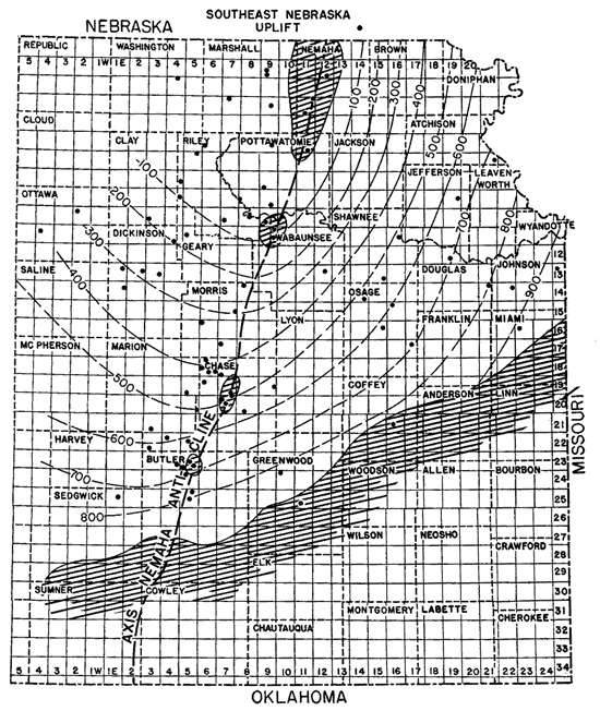
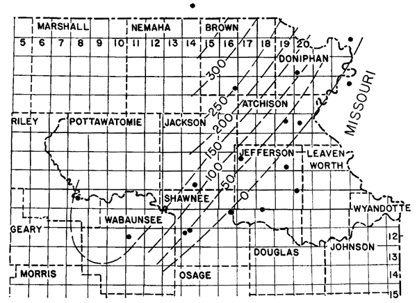
The structural deformation that took place during the Lower Ordovician and Upper Cambrian is reflected by the changes in thickness of the sequence of rocks between the Precambrian granite and the top of the St. Peter sandstone. The top of the Lamotte sandstone would have been preferable to the top of the Precambrian granite as the lower datum for this sequence because the Lamotte apparently had leveled off many of the inequalities of that surface; however, the fact that the granite has been logged in many old wells in which the Lamotte sandstone was not recorded requires the use of the top of the granite. The top of the St. Peter sandstone was chosen for the top of the sequence because it has always been carefully noted in drillers' logs. Also, the St. Peter is a widely distributed formation and is relatively thin, averaging less than 75 feet in northeastern Kansas. Although the St. Peter sandstone may represent a transgressive deposit, it is thought that within the geographical area of the map (fig. 9) its top was essentially a horizontal surface which serves as a satisfactory reference datum within the limits mapped and the 100-foot thickness interval used. The area of the thickness map is limited on the south by the Chautauqua arch in southeastern Kansas, from which the St. Peter sandstone was removed during pre-Devonian base-leveling. The St. Peter was also removed from some localities on the crest of the Nemaha anticline during post-Mississippian peneplanation.
Most of the deep wells in northeastern Kansas were drilled before it was common practice to save samples. Consequently, most of the data used in determining the top of the St. Peter are from drillers' logs. The top of the granite in most of the wells was determined by examination of samples at the time the wells were drilled. The widespread distribution of the Bonneterre dolomite and the Lamotte sandstone (fig. 4 and fig. 5) indicates that the original relief of the granite surface was generally low.
The thickness map of the sequence of rocks between the top of the St. Peter and the top of the Precambrian (fig. 9) indicates roughly the amount of deformation that occurred during the corresponding time of deposition, except for a possible slight initial dip or for irregularities at the top of the St. Peter and on the surface of the granite. By the beginning of St. Peter time, the surface of the Precambrian rocks had risen in a broad uplift whose highest parts in Kansas appear to have been in Marshall or Washington counties. Because its surface probably rose to even higher altitudes in Nebraska, it is here named the Southeast Nebraska uplift. Within the area of figure 9, the top of the Precambrian at the close of St. Peter time had attained a total structural relief of nearly 900 feet. The structural relief was more than 2,000 feet above the deepest part of the Ozark basin in Missouri. The top of the granite sloped southward from the crest of the uplift into a deep structural basin in southern Oklahoma where the pre-St. Peter sedimentary rocks have a thickness of more than 7,000 feet.
Figure 9--Map of northeastern Kansas showing thickness of rocks between the top of the Precambrian and the top of the St. Peter sandstone. Isopachous lines connecting points of equal thickness are drawn at intervals of 100 feet. Diagonal pattern indicates areas from which St. Peter sandstone has been eroded. Dots show location of wells used as source of data. A larger version of this figure is available.
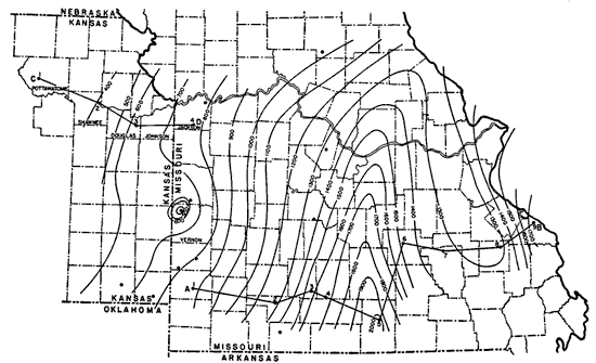
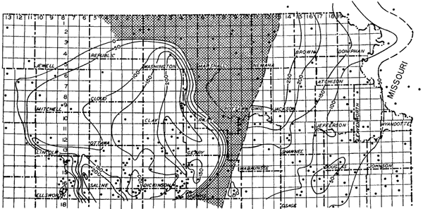
These structural movements are the first known to have deformed the sedimentary rocks of northeastern Kansas. The character of the deformation in eastern Kansas and Missouri is shown by the thickness map of the interval from the top of the Roubidoux to the top of the Lamotte sandstone (fig. 10). The Ozark basin and the Southeast Nebraska uplift appear to have been structurally complementary so that as the basin subsided the uplift rose.
Figure 10--Map of a portion of Missouri and eastern Kansas showing thickness of rocks between the top of the Lamotte sandstone and the top of the Roubidoux formation. Data in Missouri from McQueen (1931) and in eastern Kansas from samples of wells examined by R.P. Keroher. The thin section in Vernon County, Missouri, may be due either to an igneous intrusion, and unreduced Precambrian ridge, or a local structure that was active until the deposition of the Gunter sandstone member of the Van Buren formation, which in this area is reported to overlie granite.
Isopachous lines connecting points of equal thickness are drawn at intervals of 100 feet. Dots show locations of wells used as source data. Lines A-B and C-D indicate locations of cross sections shown in figures 4 and 5. A larger version of this figure is available.
Some of the structural development indicated by the thickness maps (figs. 9 and 10) took place during the frequently interrupted deposition of the early dolomites. However, inasmuch as the St. Peter sandstone is unconformably in contact with all of the older formations, a considerable part of the deformation must have occurred in the time interval represented by the unconformity at its base (fig. 5).
If the section prepared by McQueen (1931, pl. 12) across the central part of the Ozarks in southern Missouri is correlated on the Roubidoux sandstone (fig. 4), it is evident that the western part of the Ozark region was a broad subsiding synclinal basin throughout the Upper Cambrian and Lower Ordovician in which the various formations become thinner and converge toward the west. Another cross section by McQueen (1931, pl. 10) from south to north near the Kansas border shows a slight convergence of the formations below the Roubidoux toward the north, although the lower formations at one place appear either to have been deposited unconformably upon a granite hill or to be in contact with an intrusion.
The present study, as well as earlier studies by Missouri geologists, reveals a series of structural cycles whose center of subsidence lay within the Ozark basin (see figs. 4, 5, and 10). The Lamotte sandstone, which was deposited on the irregularities of the Precambrian surface, leveled off to a considerable extent the inequalities of that surface, although there were some localities in which hills survived. The wide distribution of the overlying Bonneterre dolomite indicates that it was laid down upon a low and essentially flat surface, for it is now found overlying the Lamotte not only in the deepest part of the Ozark basin but also on the upper flanks of the Southeast Nebraska uplift. A remnant of the Bonneterre seems to be present on this uplift in the Turner No. 1 Umschied well, in sec. 32, T. 8 S., R. 9 E. (fig. 5), and in other wells in the surrounding territory.
A cycle beginning with the Lamotte sandstone and closing with erosion of the Doe Run dolomite was the first of several similar cycles. In this cycle the Lamotte, Bonneterre, Davis, Derby, and Doe Run formations were deposited in conformable sequence. After the deposition of the Doe Run, the marginal deposits were warped upward very gently, the sea withdrew, and the exposed rocks were eroded to what seems to have been essentially a peneplain. The Doe Run and Derby dolomites, if they had ever been deposited in western Missouri and eastern Kansas, were eroded from the western margin of the basin.
At the beginning of the second cycle, the land surface was warped downward restoring the embayment in which the Potosi dolomite was deposited upon the beveled edges of all the older formations. The Eminence dolomite, which conformably overlies the Potosi, extended north and west beyond the Potosi dolomite and overlapped unconformably upon the eroded surface of the Bonneterre dolomite in eastern Kansas. The Proctor dolomite was then deposited upon the Eminence dolomite, but it, together with part of the Eminence, was removed from the margin of the basin during the ensuing re-elevation and peneplanation.
The third cycle may be regarded as extending from Gunter time to the close of Gasconade time, though a break took place between Van Buren and Gasconade time. The sequence of events from the beginning of Roubidoux time to the end of Smithville time is not recorded in western Missouri or northeastern Kansas. After Gasconade time, the Ozark basin appears to have sustained less warping and less beveling of marginal areas and a considerable extension of areas of deposition.
These cycles were probably more involved than is expressed in the simplified outline above. Two factors affected the areas of erosion and deposition. One factor involved changes in shore line due to rise and fall of the sea that were not accompanied by local structural movements. The other involved shore-line changes due to deformation of the basin with only incidental changes in sea level. The character of the pre-St. Peter rocks indicates that they were deposited in shallow water. Frequent brief intervals of emergence occurred, so that both the gradual expansion of the sea and the gradual emergence of marginal land areas were probably the composite result of small local deformatory movements, on the one hand, and of many large and small oscillatory changes of sea level, on the other. There were, therefore, secondary and many even less important cycles within the major cycles. The secondary interruptions to sedimentation are probably represented by such unconformities as those between the Gasconade dolomite and the Van Buren formation and between the Jefferson City dolomite and the Roubidoux formation. Cycles of less importance are indicated by ripple marks and sun cracks or may even have occurred without any obvious stratigraphic expression. The widespread deposition of the Roubidoux sandstone may be explained by assuming that the hiatus at the base of this sandstone represents simply a retreat and readvance of the sea without local warping of the basin. This type of cycle appears to have been more prevalent during the early Ordovician when the areas of deposition were greatly extended than during the late Cambrian.
With these concepts in mind, it seems reasonable to conclude that the Cotter, Powell, and Smithville formations which are missing in Kansas were originally widely deposited but probably of greater thickness in the center of the Ozark basin. Like the Davis, Derby, and Doe Run formations, their thin marginal deposits were probably removed from the shores of the basin after the final re-elevation and peneplanation of the margin of the basin that preceded St. Peter deposition. Only those pre-St. Peter formations (such as the Bonneterre, Eminence, and Gasconade dolomites) that were deposited in greatest thickness on the flank of the basin in northeastern Kansas during the maximum expansion of the Ozark sea survived the subsequent periods of exposure and erosion.
The size and configuration of the Southeast Nebraska uplift on the northwest side of the Ozark basin are as yet undetermined, but it appears to have been commensurate in size with the Ozark basin of the same period. Its configuration in Kansas is roughly suggested in figure 9, which shows the surface of the Precambrian at the close of St. Peter time. By St. Peter time all the earlier sediments had acquired a regional dip toward the south or southeast. The amount of dip increases with the depth below the St. Peter. At the end of St. Peter deposition, the Lamotte sandstone had an average dip in northeastern Kansas of 9 feet per mile toward the southeast.
Regional Deformation from the End of St. Peter Time to the End of Maquoketa Time
The amount and the direction of deformation that took place between St. Peter and Maquoketa times are indicated by the thickness of the sediments deposited during this interval, although the top and bottom of the section have been preserved in a relatively small area. The thickness map of this interval (fig. 11) indicates that the St. Peter sandstone in northeastern Kansas was tilted slightly west of north toward a basin whose central area lay north of the Kansas-Nebraska border. This basin was called the North Kansas basin by Rich (1933, p. 796), but it is probable that its deepest part was in Nebraska and that it may be only a part of a larger basin flanking the Ozark area on the north. By the end of Maquoketa time this structural movement had given the top of the St. Peter sandstone a dip toward the northwest of about 5 feet per mile.
Figure 11--Map of northeastern Kansas showing the thickness of rocks between the top of the St. Peter sandstone and the top of the Maquoketa shale.
Isopachous lines connecting points of equal thickness are drawn at intervals of 50 feet. Plus signs show locations of wells from which samples were examined. Dots show locations of wells for which data were taken from drillers logs. A larger version of this figure is available.
The subsidence in this direction and the accompanying tilt in the basement rocks must have been connected with the development of the Chautauqua arch, for the trend of the thickness contours is approximately parallel to the strike of the rocks on the northern flank of the Chautauqua arch. Another indication of the same relation is the slower decrease in thickness as the crest of the Chautauqua arch is approached. Luther H. White (1928, p. 21) reports that the pre-Sylvan (pre-Maquoketa) rocks on the south flank of the Chautauqua arch in Oklahoma also become thicker as the distance south from the Chautauqua arch increases.
The initial movements of the Chautauqua arch thus probably began after St. Peter time but before the end of Maquoketa time. During this time interval there were several interruptions in sedimentation in northeastern Kansas. One of these occurred between the deposition of the St. Peter sandstone and the Decorah shale, during which several hundred feet of rocks were deposited in southeastern Missouri. Another unconformity that occurred during the interval represented by the thickness map is revealed in the Mississippi valley. In that region the Fernvale limestone, tentatively identified in the Forest City basin below the Maquoketa, is reported by Ulrich (1939, p. 107) to overlap beds ranging in age from lower Ordovician to Trenton. It is probable that much of the deformation revealed by the thickness map in this area occurred during the time represented by these unconformities.
The identification of pre-Decorah rocks of possible Plattin age in the deeper parts of the North Kansas basin implies that the North Kansas basin was subsiding and the Chautauqua arch had begun to rise early in the time interval represented by the thickness map. The occurrence of post-Kimmswick rocks in the deeper part of the basin tentatively referred to the Fernvale would indicate that the same structural movements were going on at least to the beginning of Maquoketa time.
Regional Deformation from the End of Maquoketa Time to Pre-Chattanooga Peneplanation
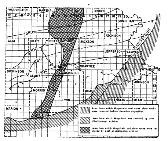
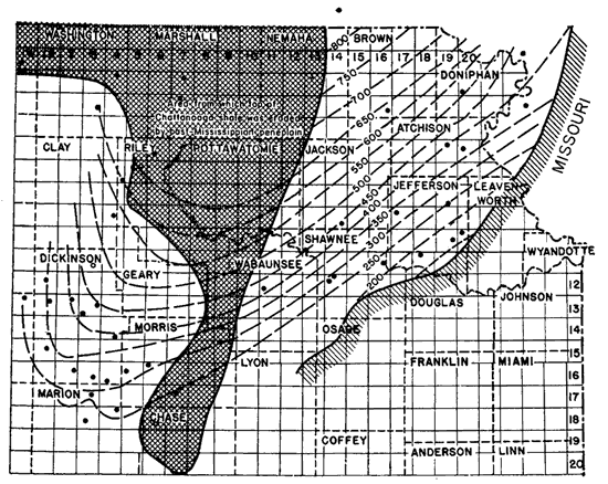
The continued development of the North Kansas basin during Silurian and Devonian time is indicated by the thickness of these rocks above the Maquoketa shale. The peneplain at the base of the Chattanooga shale was very well developed. Although some drainage is recognizable upon its eroded surface (Lee, 1940, p. 27) the beveled outcrops of all the older formations had extremely low relief. The area that may be contoured is restricted to areas in which both the base of the Chattanooga and the top of the Maquoketa have been preserved from erosion, although in some border areas where only the base of the Maquoketa has been preserved an estimate has been made of the position of its original top.
The thickness map of this interval (fig. 12) indicates a continued subsidence of the North Kansas basin. The trend of the thickness lines is approximately northeast and conforms more closely to the border of the Ozark uplift than to the Chautauqua arch. The total subsidence of the basin in Kansas during this interval was at least 700 feet, and in Nebraska it was even greater. The average increase in thickness representing deformation is approximately 8 feet per mile to the northwest.
Figure 12--Map of northeastern Kansas showing thickness of rocks between top of Maquoketa shale and the base of the Chattanooga shale.
Isopachous lines connecting points of equal thickness are drawn at intervals of 50 feet. Dots show locations of wells used as source of data. Diagonal lines show margin of area from which Maquoketa shale was removed by pre-Devonian and pre-Chattanooga erosion. Checkered area indicates area from which base of Chattanooga shale was removed by post-Mississippian erosion. A larger version of this figure is available.
This deformation occurred mainly during two distinct movements marked by angular unconformities, although some subsidence was going on during the intervening periods of sedimentation. The first interval occurred after the deposition of the Silurian of the region. It is obvious from an inspection of the cross sections (fig. 7) that after the deposition of the Silurian rocks the surface was tilted toward the northwest and eroded. The rocks were beveled although the surface may not have reached an advanced stage of peneplantion. Some idea of the amount of erosion that took place can be gained from the fragmentary thickness map of the Silurian (fig 13). Several hundred feet of Silurian strata may have been eroded toward the southeast. Probably more Silurian rocks were removed from the area contoured than remain.
Figure 13--Map of northeastern Kansas showing the thickness of rocks of Silurian age. The Silurian rocks were originally widely distributed in Kansas and Missouri, then were tilted and beveled by pre-Devonian erosion. The contact between Silurian and Devonian rocks cannot be sharply differentiated northwest of the 150-foot thickness line. The thickness of 150 feet in Riley County is tentative, but the pattern indicated is in harmony with the geologic history shown in figures 12 and 15. Southeast of the line of zero thickness, the Silurian was removed by pre-Devonian erosion.
Isopachous lines connecting points of equal thickness are drawn at intervals of 50 feet. Dots show locations of wells from which samples were examined.
The other period of tilting and beveling occurred after the deposition of the Devonian. The thickness of the Devonian strata indicates that more than 300 feet of Devonian rocks were eroded from the margin of the basin. Luther H. White (1928, p. 21) has indicated that in northeastern Oklahoma the interval from the top of the Sylvan (Maquoketa) shale to the base of the Chattanooga shale increases similarly away from the Chautauqua arch on its south side. In that area the thinning is due to tilting into a basin to the south and the elevation and subsequent erosion of the Chautauqua arch. It is probable that during this period some local structural movements occurred, but the information from Kansas is inadequate for proof. There is evidence in the Dawson pool, T. 1 N., R. 14 E. in Nebraska, that local deformation occurred between the deposition of the Maquoketa and Silurian rocks for in the Arab No. 1 Ogle well of that pool the foraminiferal zone of the Silurian, normally more than 50 feet above the Maquoketa, is in contact with the weathered and eroded surface of the Maquoketa shale.
Regional Deformation Indicated by the Thickness of the Chattanooga Shale
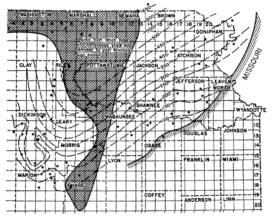
The continued subsidence of the North Kansas basin through Chattanooga time is indicated by the pattern of the thickness lines of the Chattanooga, as shown by Lee (1940, p. 28) and by figure 14 in which changes of the thickness lines involving local detail have been made from recently acquired data.
Figure 14--Map of northeastern Kansas showing the thickness of the Chattanooga shale. The thickening of the Chattanooga shale toward the north indicates that the sinking of the North Kansas basin continued into Chattanooga time. The irregularities in the smoothness of the contours seem to be the expression of topographic relief upon the pre-Chattanooga peneplain (see fig. 12). In Dickinson County the thickness map of the Chattanooga and the underlying rocks is detailed enough to show thinning of the underlying rocks where the Chattanooga is thickest.
Checkered pattern shows area from which Chattanooga shale was removed by post-Mississippian erosion. Isopachus lines connecting points of equal thickness are drawn at 50-foot intervals. Dots show locations of wells used as source data. A larger version of this figure is available.
Comparison of this thickness map with maps showing the thickness of the St. Peter-Maquoketa sequence and the thickness of the Maquoketa-Chattanooga sequence reveals a progressive change in the strike of the thickness lines on the southeastern side of the North Kansas basin. During the interval from St. Peter to Maquoketa, the strike was east-northeast; from Maquoketa to pre-Chattanooga peneplanation the strike turned to northeast, and during the Chattanooga to north-northeast. This change in direction of strike indicates a gradually southward shift of that part of the North Kansas basin toward which the margin was being tilted and may be related to strains antecedent to the Nemaha anticline; The subsidence of the North Kansas basin during the deposition of the Chattanooga shale was the last movement affecting this basin before the first recognizable movement of the Nemaha anticline, although east of the anticline sinking of the basin continued until the deposition of the Chouteau limestone of Kinderhookian age.
Irregularities in the thickness of the Chattanooga shale in Dickinson county have been interpreted as expressing drainage lines on the pre-Chattanooga peneplain. It is interesting to note that compensating thinning occurs in the Devonian rocks in the same areas as shown in figure 12, thus confirming the conclusion of measurable relief on the pre-Chattanooga surface. To avoid the use of the imperfectly peneplaned pre-Chattanooga surface, a thickness map showing the interval between the top of the Maquoketa and the top of the Chattanooga was prepared (fig. 15). In this map the irregularities caused by the imperfections of the pre-Chattanooga peneplain in figures 12 and 14 have been eliminated. During the deposition of the rocks represented by figures 11 and 15 the North Kansas basin presents a record of intermittent subsidence.
Figure 15--Map of northeastern. Kansas showing thickness of rocks between the top of the Maquoketa shale and the top of the Chattanooga shale.
Checkered pattern shows area from which top of Chattanooga shale was removed by post-Mississippian erosion. Diagonal lines show margin of area from which top of Maquoketa shale was removed by pre-Devonian and pre-Chattanooga erosion. Isopachous lines connecting points of equal thickness are drawn at intervals of 50 feet. Dots show locations of wells used as source data. A larger version of this figure is available.
The North Kansas basin and its complementary positive areas, the Chautauqua arch and the Ozark uplift, dominated the structural history of northeastern Kansas from the end of St. Peter time at least until the end of Chattanooga time. It thus provides an interesting example of the reversal of this type of structural movement. The central Ozark region had been a negative and sinking area and southeastern Nebraska had been a positive or rising area from the deposition of Bonneterre limestone to St. Peter time. From St. Peter time to the end of Chattanooga deposition (possibly through the deposition of the Chouteau limestone) the Chautauqua arch and probably the Ozark area were positive and rising areas and southeastern Nebraska a negative and subsiding area. The structural deformation during both periods was only a few feet per mile and was more in the nature of a ground swell than of directional folding. The regional aggregate of the differentially distributed epeirogenetic movements involved in the subsidence of the Ozark basin in Missouri, however, amounted to about 2,000 feet of structural relief; the subsidence of the North Kansas basin was not less than 1,400 feet.
Early Mississippian Deformation
The earlier part of the post-Devonian structural history of eastern Kansas is revealed by the distribution of the Mississippian formations. Initial movements of the Nemaha anticline are suggested as early as the Kinderhookian by the distribution of the lower two members of the Chouteau limestone which are confined to the area east of the Nemaha anticline. The thin upper member of the Chouteau, once doubtfully referred to the Sedalia (Lee, 1940, p. 37), extends west across the axis of the fold. The Chouteau east of the axis thickens northward into the eastern half of the North Kansas basin. This is interpreted to mean that during the deposition of the Chouteau limestone the North Kansas basin was still active, although initial folding had already begun on the Nemaha anticline.
Slight folding in Osagian time along the trend of the Nemaha anticline is indicated by the distribution of limestones of Fern Glen age in synclinal areas both east and west of the Nemaha anticline and by the absence of these formations beneath the Burlington in intervening areas on its crest and flank. At the time of deposition of the Short Creek oolite near the close of the Keokuk, there was a greater interval from the Short Creek oolite to the Chattanooga shale east of the Nemaha anticline than west of it, again suggesting Osagian subsidence east of the Nemaha fold. During Osagian and Meramecian time there appears to have been a gradual tilt of all of eastern Kansas toward the south, for most of the formations younger than Kinderhookian thin toward the north.
The Nemaha Anticline
The minor and obscure structural movements just described as having occurred during the deposition of the Mississippian rocks gave way to a pronounced change in the pattern of structural movement at the end of Mississippian sedimentation. The principal phenomenon was the development of the Nemaha anticline, which extended from southeastern Nebraska to central Oklahoma with a trend slightly west of south. Secondary and subsidiary parallel folds such as the Voshell anticline were also developed.
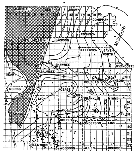
After the first stage of folding of the Nemaha anticline the region was peneplaned. The thickness of the rocks from the top of the Chattanooga to the peneplaned surface (fig. 16) reveals the approximate structural deformation that had occurred prior to peneplanation. The dip on the east flank of the anticline, although not uniform in different parts of the area, averaged about 5 feet per mile to the east.
Figure 16--Map of northeastern Kansas showing thickness of limestones of Mississippian age.
Isopachous lines connecting points of equal thickness are drawn at intervals of 50 feet. Checkered pattern shows area from which Mississippian limestones were removed by post-Mississippian erosion. Crosses show locations of wells from which samples have been examined. Dots show locations of wells from which only logs are available. A larger version of this figure is available.
At the close of peneplanation the area west of the Nemaha anticline was raised above the area on the east probably with faulting with the formation of an eastward-facing escarpment several hundred feet high rising above a basin (the Forest City basin) formed by the subsidence of the peneplain east of the anticline. The nature of the escarpment formed on the east side of the Nemaha anticline has long been a subject of debate. There can be little doubt that the displacement in some places was produced by faulting, but it seems possible that in many places it was the result of sharp monoclinal dip.
Before 1914 geological concepts of the structure and stratigraphy of northeastern Kansas were based on interpretations of surface outcrops in Missouri and Kansas and on the study of occasional logs of wells of no great depth drilled for oil, gas, or water. From the available information, it was generally believed that, although unconformities were known to occur in the pre-Pennsylvanian rocks of Missouri, the older rocks and the Precambrian surface dipped more or less regularly beneath the Pennsylvanian strata westward from the Ozark region into a deep but somewhat vaguely localized basin east of the Rocky mountains. Oil wells in eastern Kansas up to that time were not drilled below the Pennsylvanian rocks and yielded no data contrary to the accepted theory.
When granite was reported at 958 feet in an oil test near Zeandale in Riley County, Kansas in 1914, it aroused much interest among geologists. Granite had been reported earlier at even shallower depths in wells drilled for water in southeastern Nebraska and northeastern Kansas, but as no samples had been saved, the reports had generally not been credited. Another well near Zeandale and two wells near Elmdale, Chase County, were drilled into granite within a few months after the Zeandale well and confirmed the original discovery. The belief that granite would be found only at much greater depths was so firmly held, however, that some geologists refused to accept the discoveries, and a number of interesting and ingenious reasons were suggested for discrediting the evidence (Haworth, 1915). Since that time the understanding of the structure and stratigraphy of the region has greatly increased as a result of the large number of deep wells that have been drilled in the search for oil and gas.
It was at once recognized that the wells with granite at shallow depths were aligned with a series of surface anticlines and that in northern Kansas, where the first discoveries were made, the Pennsylvanian rocks were unconformable upon the granite. It was also correctly surmised that the granite was Precambrian in age. It was at first assumed that a range of Precambrian mountains had existed in northeastern Kansas and that its higher peaks had kept above the level of sedimentation until early Pennsylvanian time.
As the number of granite wells increased, modifications of this theory appeared. Taylor (1917, p. 118) expressed the view that the granite was a part of an ancient land mass with jagged peaks projecting above the general level of the region, but, noting the absence of clastic rocks in the Mississippian, he concluded that there might have been "rather intense though local deformation during the latter part of the Mississippian or the early part of the Pennsylvanian period . . . followed by rapid truncation of the folds." Moore and Haynes (1917, pp. 167, 169) presented a more detailed discussion, and stated that the phenomena observed clearly indicate "an uplifted ridge [which they named the "Nemaha Granite Mountains" from Nemaha county where the deformation of the surface rocks is most pronounced] forming an essential part of the crystalline basement . . ." and that the relations indicate "a rather pronounced though local deformation in central Kanses in late Mississippian or early Pennsylvanian time, followed by rapid erosion which removed all of the sediments covering at least the top of the granite." They also wrote, "the absence of [sedimentary] rocks older than the Pennsylvanian . . . may be accounted for by the supposition . . . that they have been deposited as in neighboring areas but have been removed by subsequent erosion."
Sidney Powers (1917, p. 150) thought that the evidence suggested "that in the beginning of Pennsylvanian time, they [the Nemaha mountains] presented an appearance similar to that of the Wichita mountains at the beginning of Permian time . . . The mountain system must have been formed in the Cambrian, the lower Paleozoic [pre-Silurian], or in the Mississippian." In 1920 A. E. Fath who had studied the granite ridge (as it was then generally known) in Butler County, concluded that "the granite ridge did not come into existence until post-Boone time [middle Mississippian] . . . and that the ridge was elevated during the widespread erosion between the Mississippian and Pennsylvanian epochs."
In 1920, Eliot Blackwelder (1920, p. 92) had suggested that gravitational compaction of sediments over crests of hills on the trend of the "buried ridge" could explain the observed relation between the local structure of the Pennsylvanian strata and the supposed granite knobs. This theory, elaborated by Sidney Powers (1925) and others, was applied to the Nemaha anticline and other midcontinent structural features, and dominated the thought on the subject until 1926 when the accumulated data from deeper drilling caused a readjustment of the concepts.
In January 1926, Henry Ley (1926, p. 96) in a brief communication in the Bulletin of the American Association of Petroleum Geologists, published his conclusions that the granite ridge was a "southward pitching anticlinal fold" and that "south of Chase County, the Pennsylvanian beds rest on the 'siliceous' lime." He stated also that
In late Mississippian or early Pennsylvanian time, the entire region emerged and the granite ridge was elevated a thousand feet or more above the surrounding country. In the long interval before the advance of the Pennsylvanian seas, erosion stripped the Mississippian and even older rocks from the axis of the ridge. The ridge was thus reduced practically to the base-level of the surrounding country which at no time appears to have had an altitude more than 50 to 100 feet above sea level.
This brief and concise statement appears to have been favorably received and generally accepted by geologists. Two months after the publication of this communication the same ideas slightly modified were presented by R. C. Moore (1926, fig. 2) in a series of block diagrams prepared to illustrate an article on another subject.
In 1930, Hugh W. McClellan (1930, p. 1553) in an article on the distribution of pre-Mississippian rocks, stated that he had found no conclusive evidence of post-Devonian movement in faults on the east side of the Nemaha ridge. He interpreted the evidence to mean "that the granite ridge did not exist at that time." Later McClellan (1940, p. 20) restated that he had "never been able to find any proof of its existence before the post-Mississippian folding."
In 1931 Rich (1931, p. 1437) expressed the same ideas as McClellan (1930) and pointed out the post-peneplain development of the Cherokee basin. He also noted that north of El Dorado the granite ridge "seems not to have been covered until late Cherokee or the beginning of Marmaton time." In 1934, Tomlinson (1934, p. 571) refers to the Nemaha mountains as "a truncated anticline in pre-Pennsylvanian rocks," This conclusion is now firmly established.
Deformation of the Post-Mississippian Peneplain
The regional relief of the pre-Pennsylvanian surface measured from the Ft. Scott limestone, which amounts to several hundred feet, is due chiefly to faulting on the east flank of the Nemaha anticline and to deformation of the post-Mississippian peneplain, although there were later slow increments of folding throughout the Pennsylvanian and there is no doubt that in some places there was erosional relief of the pre-Cherokee surface (Lee, 1939). This conclusion rests on the following observations. (1) The Mississippian limestones on the downthrow side of the sharp displacement along the east side of the Nemaha anticline are beveled in the same way that the same rocks are beveled on the elevated west side of the anticline. (2) A greater thickness of the Cherokee shale occurs on the east side of the Nemaha anticline than on the west side, and the crest of the beveled anticline in most places was not covered until Marmaton time or later. (3) The topographic high points of the pre-Pennsylvanian surface are on beveled Mississippian limestones and are also beneath anticlines where the Pennsylvanian and Permian rocks are thin.
The Nemaha anticline cuts the North Kansas basin into two structural basins which have had a slightly different history. The Salina basin revealed by the thickening of the Mississippian limestones below the post-Mississippian peneplain (Lee, 1939) lies west of the Nemaha anticline and was slightly rejuvenated during the post-peneplain re-elevation. The corresponding structural basin east of the Nemaha anticline follows the Missouri River in northeastern Kansas and contains a thick sequence of Mississippian limestones including the Ste. Genevieve limestone at the top (fig. 16). The Salina basin and its counterpart east of the Nemaha anticline were both beveled pre-peneplain synclines.
On the contrary, the Forest City basin and the contemporaneous Cherokee basin farther south were topographic basins formed by sharp displacement on the east flank of the Nemaha anticline and by the warping of the peneplaned surface at the top of the Mississippian rocks. The deepest part of the Forest City basin, as shown in figure 7, was about 50 miles west of the earlier beveled syncline developed east of the Nemaha anticline contemporaneously with the Salina basin. This eastern beveled syncline is not known to have been further deformed at the time of the re-elevation of the region to the west and cannot be regarded as the initial movement of the Forest City basin. Neither the Forest City basin nor the Cherokee basin, both of which were topographic features, came into existence until after the development of the peneplain.
Renewal of deformation during the deposition of the Cherokee is indicated by the position of an unnamed dark crinoidal limestone in the Cherokee shale. This limestone is 265 feet above the base of the Cherokee in the deepest part of the Forest City basin in Nemaha county, 210 feet above the base in the Forest City well on its eastern flank, an average of 60 feet above the base in the McLouth field, and 90 feet above the base in Franklin County. Local minor folding also was going on during Pennsylvanian time, as is shown by all the local anticlines in the McLouth field which reveal increasing amounts of deformation with depth.
Detailed maps showing the thickness of the Cherokee shale reveal dendritic drainage patterns on the pre-Pennsylvanian surface. Where the lower Cherokee rocks are thick in the McLouth field, limestones as low as undivided Burlington and Keokuk have been found at the top of the Mississippian. On the other hand, the broad anticlinal area of the McLouth field is in general underlain by Spergen limestone. The relations indicate that the McLouth area lies upon a broad flat northward-trending pre-Cherokee anticline whose crest at the top of the Mississippian is now about 300 feet above the bottom of the Forest City Basin. Pre-Pennsylvanian drainage of this surface channeled the flanks of the anticline but did not completely destroy the fundamental relation of the thin Mississippian and thin lower Pennsylvanian rocks on the crest of the anticline.
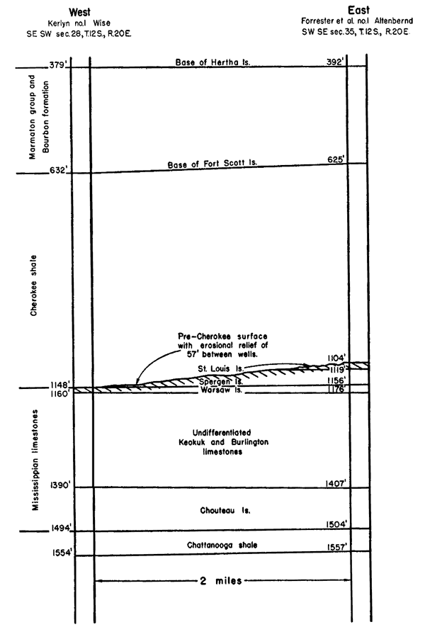
The relation of the eroded surface of the Mississippian to the Hertha limestone and to the Chattanooga shale in two wells in northern Douglas County is shown in figure 19. The increase in the thickness of the Pennsylvanian rocks in the Wise well to compensate for the thinning of the Mississippian and the fact that the thick Pennsylvanian section overlies undivided Burlington and Keokuk limestone and that the thin Pennsylvanian overlies the St. Louis limestone is interpreted as the result of pre-Pennsylvanian erosional relief. Other similar but less striking instances have been noted. The relation between the Schiltz No. 3 Davis well, in sec. 33, T. 18 S., R. 18 E., and the Hollet No. 1 Koontz well, in sec. 21, T. 18 S., R. 19 E., shows that both deformation and erosion took place after post-Mississippian peneplanation. Although it is true that the Mississippian limestones were thinned on the crest of anticlines by peneplanation, there is evidence to indicate that there was also some local pre-Pennsylvanian erosion which developed entrenched drainage lines in this part of Kansas. The thinning of the Mississippian rocks in northeastern Kansas is, therefore, a less reliable criterion of anticlinal structure than it is in central Kansas. The thickness of the overlying lower Pennsylvanian rocks and the particular formation encountered at the top of the Mississippian must also be taken into account in determining the relation of the thickness of the Mississippian to structure.
Figure 19--Cross section between the Wise and Altenbernd wells in Douglas County, Kansas, showing erosional relief of 57 feet on top of Mississippian limestones. The wells are 2 miles apart. Both St. Louis and Spergen rocks were eroded at the Wise well.
Numbers at left of wells show depths below the surface.
The three areas in which Mississippian limestones are thin in southern Douglas County and in central Franklin County (Lee, 1940, pl. 1) are areas in which the Cherokee rocks are thick (figs. 17 and 18). In the light of information now available, the thinning of the Mississippian in these places is interpreted as due to pre-Pennsylvanian erosion of the Mississippian surface. A slow and gentle growth of most of the post-Mississippian local structural features continued through the Pennsylvanian and probably into the Permian. Most of the local structural features are parallel to the Nemaha anticline and it is presumed that these folds accompanied development of that anticline.
Regional Deformation During the Pennsylvanian
The thickness of the sequence of rocks between the top of the Mississippian and the base of the Hertha limestone includes the Cherokee shale and the Marmaton and the Bourbon groups (see figs. 17 and 18). Unlike most other sequences for which thickness maps have been prepared, this sequence is bounded below by a peneplaned surface modified by deformation and erosion. The upper limit of the sequence was essentially horizontal. The thickness maps (figs. 17 and 18), therefore, indicate the nature and magnitude of the structural movements that took place between development of the post-Mississippian peneplain and the deposition of the Hertha. The indicated magnitude of these structural movements is only an approximation because there was local erosion of the peneplain before submergence. Discrimination between structural relief and erosional relief, two factors that control the thickness, cannot be made with any confidence from logs of single wells. In the McLouth field and adjoining areas, where samples from about 150 wells have been examined, the distinction between erosional and structural variations can be made with confidence in some localities. Where there is an abrupt increase in the interval from the lowest datum bed in the Cherokee to the top of the Mississippian and where in the same place the upper beds of the Mississippian are absent, it is obvious that erosion has occurred. On the other hand, where the thickness interval shows regularity of thinning or thickening in broad areas, it is probable that structural deformation is involved.
Figure 17--Maps of northeastern Kansas showing thickness of (A) rocks of Cherokee, Marmaton, and Bourbon age, and (B) rocks of Bronson, Kansas City, and Lansing age. Isopachus lines connecting points of equal thickness are drawn at intervals of 50 ft. A larger version of this figure is available.
Figure 18--Maps of northeastern Kansas showing thickness of (A) rocks between the top of the Lansing group and the base of the Shawnee group, and (B) rocks of Shawnee age. Isopachus lines connecting points of equal thickness are drawn at intervals of 50 ft. A larger version of this figure is available.
Interpretation of the structural significance of the thickness map is doubtful in many areas in northeastern Kansas, particularly where few samples are available for examination. Erosion of the top of the Mississippian is clearly demonstrable on the flanks of the McLouth arch, in the belt between Lawrence and DeSoto, T. 12 S., Rs. 20 and 21 E., and in Douglas and Franklin counties. Erosion is probably responsible for many of the other local eccentricities of thickness shown. It appears certain that the McLouth arch, the area of thinning that extends from southeastern Jefferson County into southern Doniphan County, is of structural origin, although the surface of the Mississippian on its top and flanks was affected by erosion before being covered. A pronounced valley trending northwest was cut in the surface in T. 9 S., R. 19 E. cutting off an area to the southwest that is probably not a part of the McLouth arch but an outlier of St. Louis limestone. The trough in the northern part of T. 9 S., R. 20 E. is the result of structure and erosion. It is uncertain as yet whether the well-developed valley in T. 12 S., Rs. 20 and 21 E. has cut across this arch or lies south of it. It is uncertain also whether the thin areas in the thickness map in western Osage, southern Wabaunsee, and northwestern Shawnee counties represent primarily structural or erosional elements.
The abrupt thinning of the lower Pennsylvanian rocks from more than 1,000 feet in Nemaha county to about 100 feet in Pottawatomie County, just west of the crest of the Nemaha anticline, indicates a profound displacement on the east flank of the anticline. This displacement was formed by a fault or a sharp monoclinal fold and was a prominent east-facing escarpment. It is worthy of comment that the McLouth arch, the deepest part of the Forest City basin, and the Nemaha anticline and the associated escarpment have approximately the same trend.
The thickness variations of the three limestone groups of the Missourian series (Bronson, Kansas City, and Lansing) combined are shown in figure 17B. Little structural movement of a regional character is indicated during the time interval represented by the deposition of these rocks. There is a gradual thinning of the deposits toward the north from about 400 feet near Emporia to about 300 feet near the Nebraska line. This is interpreted as the result of a gentle regional tilting toward the south. There is a slight, although vague, thinning in the uplifted area west of the Nemaha anticline and a slight thickening in the Forest City basin area, which by this time had become merely a northern extension of the Cherokee sea. These changes in thickness, though, low, probably indicate slight movement both along the Nemaha escarpment and in the basin to the east.
The thickness of the rocks from the top of the Stanton limestone to the base of the Oread limestone is shown in figure 18A. This interval includes the shale deposits of the Pedee and Douglas groups. The time interval represented by the deposition of these rocks is augmented by unconformities within these groups and by the unconformity that separates the Missourian and Virgilian series. The map shows a gradual convergence of the limiting surfaces toward the west from more than 350 feet in the syncline in southwestern Douglas County to 50 feet in Riley County. There is local thickening in the synclinal extensions of the Cherokee basin. The thickness map is interpreted as indicating a revival of synclinal folding which was greater toward the south than toward the north, but with little or no activity of either the Nemaha anticline or the eastward-facing escarpment.
The thickness map of the Shawnee group (fig. 18B) shows only moderate changes in thickness east of the Nemaha anticline, but abrupt thinning from more than 350 feet east of the escarpment to less than 250 feet on the crest. The thickness relations suggest that during Shawnee time the synclinal flexing of the Cherokee basin declined but that movement along the escarpment was revived.
Post-Pennsylvanian Structural Movements
The cross section of Kansas prepared by Betty Kellett (1932) shows pre-Cretaceous westward tilting and also truncation of Permian rocks by Lower Cretaceous rocks. Therefore, much of the westerly dip that characterizes the surface rocks of the present day took place prior to the deposition of the Lower Cretaceous rocks of Kansas. The Cretaceous rocks were deposited at or below sea level but have been raised several thousand feet to their present position without much tilting or regional deformation. The westward dip of the surface rocks of Pennsylvanian and Permian age of northeastern Kansas is now about 15 feet per mile. The eastern limit of the Permian sea is unknown, but there is good reason to believe that at least 2,000 feet of sediments at one time were deposited above the Lansing limestone in northeastern Kansas. Such a thickness must have carried the Permian rocks into the Mississippi valley where no trace of them survives.
Prev Page--Stratigraphy--Permian || Next Page--Anticlines
Kansas Geological Survey, Forest City Basin
Comments to webadmin@kgs.ku.edu
Web version July 2005. Original publication date Dec. 1943.
URL=http://www.kgs.ku.edu/Publications/Bulletins/51/04_devel.html