![]()
Prev Page--Structural Development || Next Page--Stratigraphic Traps
Structural Development of Anticlines
The direction and amount of regional dip, as already pointed out, have varied widely at different periods in the structural development of the region and at times in different places during a single period. From the relations of pre-Mississippian and post-Mississippian regional structure it is concluded (Lee, 1939, p. 32) that the Nemaha anticline and other northeasterly trending folds did not develop until the end of Mississippian time. These folds continued their growth by small increments of deformation durthe deposition of Pennsylvanian and Permian rocks.
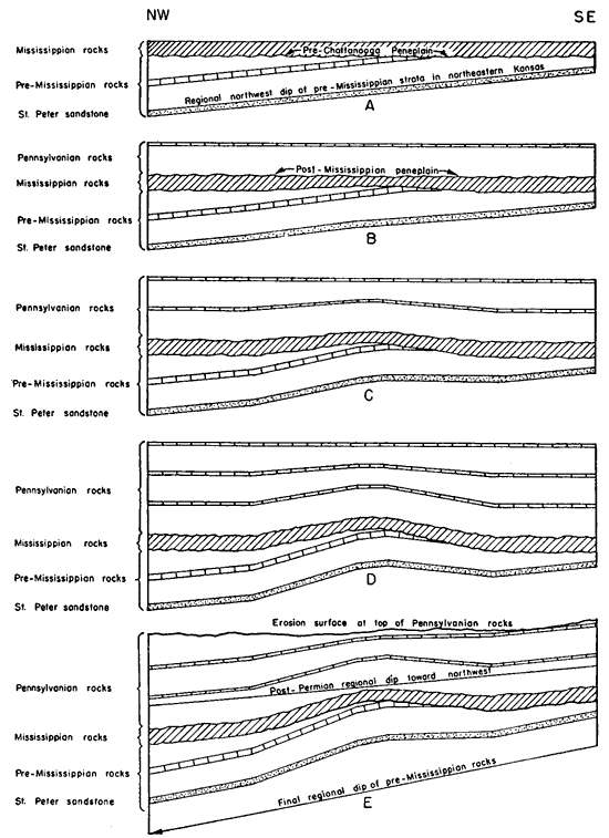
The relation between surface anticlines of low structural relief and deeper rocks in which the regional dips increase with depth is illustrated in figures 20 and 21. The effect of late deformation on rocks in which the cumulative regional dip has been mainly in the same direction as on the southeast side of the Forest City basin is illustrated in figure 20. The effect of surface folds on the deeper rocks where the regional dips have been at times in opposite directions is illustrated in figure 21. The structural features shown on all three figures are greatly exaggerated, for they are sketches that have not been drawn to scale. The principles involved in the formation of these structural features appear, as will be noted from the following discussion, to be applicable to the structural features of the Forest City basin.
Figure 20--Diagrammatic cross section on the east side of the Forest City basin showing relation of surface anticlines to folds in older rocks with strong regional dips. A, Mississippian rocks were deposited upon a peneplaned surface of northwestward dipping rocks. B, Post-Mississippian erosion on a low post-Mississippian fold followed by deposition of early Pennsylvanian rocks. Note structural closure in beds at base of Mississippian but lack of closure in underlying tilted formations. C, Increased folding during deposition of early Pennsylvanian rocks. Note lack of structural closure in the St. Peter sandstone. D, Further increase of folding during deposition of Pennsylvanian produces a limited area of closure in pre-Mississippian rocks. E, A regional northwestward tilting of the entire section in post-Permian time. Low folds in upper Pennsylvanian rocks are reduced to structural noses or terraces; closure of stronger folds in lower Pennsylvanian and Mississippian rocks is reduced in areal extent and closure in pre-Mississippian rocks is lost. A larger version of this figure is available.
Most of the anticlines mapped on the surface rocks of northeast Kansas are of low structural relief and have small easterly dips. In the oil and gas fields of the area that have been studied, however, the structural relief increases materially with depth. The increase in structural relief of most of such anticlines in early Pennsylvanian and Mississippian rocks is great enough 1:o result in easterly dips in depth in spite of the earlier low cumulative regional dips of 10 to 12 feet per mile to the west in the older rocks. Changes in the direction of regional dip at different times, however, may alter the amount of closure and the position of the crest in the older rocks.
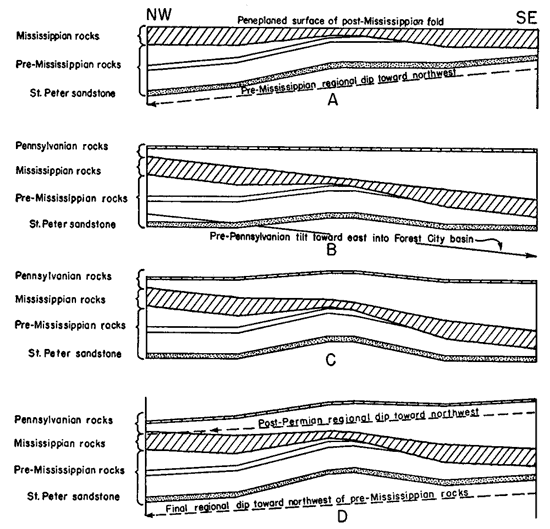
Figure 21--Diagrammatic cross sections on the west side of the Forest City basin showing the relation of surface anticlines to folds in older rocks where regional tilting to the east is followed by folding and then regional tilting to the northwest. A, Peneplanation of post-Mississippian fold. The folding is not strong enough to cause more than a monoclinal fold in northwestward-dipping pre-Mississippian rocks. B, Pre-Pennsylvanian tilting toward the east during the development of the Forest City basin. The eastward dip nearly destroys the structural closure at the base of the Mississippian, but the monoclinal fold becomes the east flank of an anticline. C, Increased folding during deposition of the Pennsylvanian produces an anticline in the Pennsylvanian rocks. The structural closure in the anticline at the base of the Mississippian is slightly increased and the position of the crest is shifted. Structural closure in pre-Mississippian rocks is increased also. D, Northwestward regional tilting of the entire section of rocks in post-Pennsylvanian time. Structural closure in Pennsylvanian rocks is reduced or destroyed but is increased at the base of the Mississippian. Closure in pre-Mississippian rocks is decreased but not lost. A larger version of this figure is available.
Regional tilting of the region, such as occurred after the Pennsylvanian, reduces the amount of closure of the anticlines in the tilted rocks. Low anticlines in exposed rocks existing prior to the regional tilting may be reduced in this way to a bench or a structural nose, as illustrated in cross section, diagram E of figure 20 and in diagram D of figure 21. Where there is a considerable thickness of Pennsylvanian rocks below the surface, the amount of folding generally increases materially with depth, for these rocks were being progressively deformed during deposition. The regional dip may thus reduce the expression of a low anticline at the surface to a structural nose, but the increase in the amount of folding in depth will prevent loss of closure in the older Pennsylvanian rocks and in the Mississippian. On account of the increase of structural deformation with depth, a structural nose at the surface indicates the probability of a closed anticline below the surface and a low anticline may safely be expected to develop greater structural relief down to the Mississippian. In a low surface anticline, however, the regional dip may induce a shift in the position of the crest up dip from its position in the deeper rocks. These relations are well exemplified in the McLouth field.
Although there is an increase in structural relief in depth from middle and upper Pennsylvanian rocks down to the Mississippian, there is only slight increase in passing downward from basal Pennsylvanian rocks into the Mississippian. Thus the closure of weak anticlines mapped on lower Pennsylvanian rocks will probably be destroyed in the older rocks by the regional dip as shown on the St. Peter sandstone in diagram E of figure 20.
The average dip of the St. Peter sandstone on the eastern side of the Forest City basin is about 20 feet per mile toward the northwest (see fig. 22). The dip becomes less in the deeper parts of the basin, and although the control for contouring is inadequate it appears probable that in a narrow belt on the east side of the Nemaha anticline the St. Peter has a dip toward the east. Comparative figures for the dip in feet per mile for the top of the St. Peter sandstone and for the base of the Hertha limestone between selected wells are shown in figure 22. It will be noted that dips at the top of the St. Peter on the southeastern side of the Forest City basin are two or more times as steep as the corresponding dips at the base of the Hertha and that in the deeper parts of the basin they are about the same.
Figure 22--Contour map of northeastern Kansas and adjacent areas showing the structure of the top of the St. Peter sandstone.
The average rate of dip of the base of the Hertha limestone is indicated by figures in feet per mile above the lines connecting the wells, and the dip of the top of the St. Peter sandstone by figures below the lines. The arrows indicate the direction of dip between wells. Altitudes of contours are in feet below sea level. Structure contour interval is 100 feet. A larger version of this figure is available.
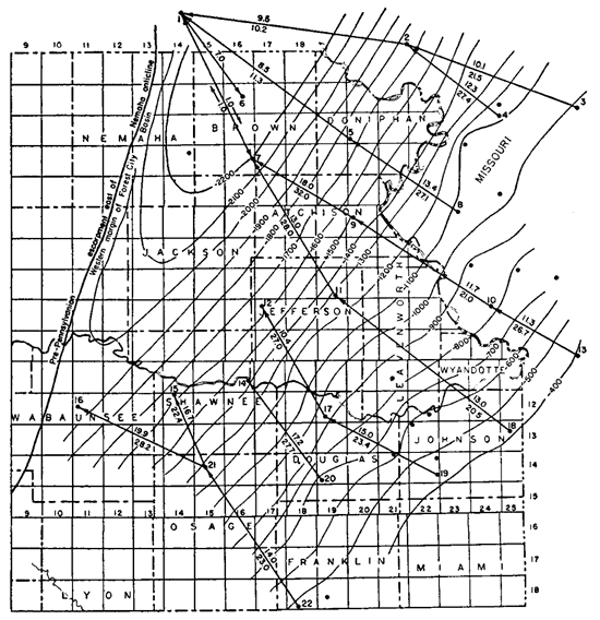
On the east side of the basin only those surface anticlines that have southeasterly dips of more than 20 feet per mile or those whose dip in this direction increases in depth to more than 20 feet per mile may be expected to form anticlines in the St. Peter sandstone. The crest of folds that register as low anticlines in the St. Peter sandstone will be found to shift materially up dip. On the other hand, anticlines in the deepest part of the Forest City basin and on its narrow western side probably overlie anticlines in the St. Peter of commensurate size with those at the base of the Hertha limestone.
Northwestward trending folds--The previous discussion applies to the northern or northeastward trending anticlines or other folds initiated contemporaneously with the Nemaha anticline at the end of Mississippian time. The age and relations of the northwestward trending folds are less well known.
Northwestward trending folds of regional character are represented in eastern Kansas by the Chautauqua arch, along which movement began shortly after deposition of the St. Peter sandstone. The Central Kansas uplift is a continuation of the Chautauqua arch and was probably initiated at the same time. Contemporaneous also is a syncline flanking the Central Kansas uplift on the north. This syncline constitutes one element of the subsequently formed Salina basin. Prior to the development of the Nemaha anticline this syncline appears to have continued to the southeast across the trend of the later formed Nemaha anticline, for the Nemaha anticline is interrupted by a saddle which is revealed by the thickness map of the Mississippian rocks (Lee, 1939, p. 32 and pl. 1) in continuation of the Salina syncline. Not enough deep wells have been drilled through the pre-Mississippian rocks in most areas to prove the early age of the northwestward trending folds. It appears probable that the Bourbon arch, the northern flank of the Salina basin, and other less well defined northwestward trending structural features expressed in the Mississippian and younger rocks are the result of renewed movement of structural features initiated contemporaneously with the Chautauqua arch. Local northwestward trending folds, such as the northwestward trending productive anticlines in Chautauqua, Elk, and Wilson counties revealed by thinning of the Mississippian formations and other similar folds elsewhere expressed in Mississippian and younger rocks, may also have been initiated prior to the Nemaha anticline and subsequently revived. The northwestward trending folds of low structural relief that have been mapped in the Pennsylvanian surface rocks of Miami, Johnson, and other counties of northeastern Kansas and in Missouri may also have had a pre-Mississippian history.
The structural relief of folds initiated in pre-Mississippian time may be expected to increase with depth below the Mississippian; and, other conditions being equal, adequately closed northwestward trending anticlines, if any exist in northeastern Kansas, would thus be more favorable for the occurrence of oil and gas in the deep zones than the northeastward trending anticlines.
Prev Page--Structural Development || Next Page--Stratigraphic Traps
Kansas Geological Survey, Forest City Basin
Comments to webadmin@kgs.ku.edu
Web version July 2005. Original publication date Dec. 1943.
URL=http://www.kgs.ku.edu/Publications/Bulletins/51/05_anti.html