Prev Page--Table of Contents || Next Page--Stratigraphy--Cambrian
Introduction
This report represents a part of the results of investigations of the structure and stratigraphy of that part of the Forest City basin lying in Kansas and their relation to the occurrence of oil and gas in northeastern Kansas. The report is primarily a subsurface study based on the examination of samples from wells and supplemented by surface observations on stratigraphy of adjacent regions in which some of the rocks are exposed. The report discusses the stratigraphy and distribution of all the rocks in the Forest City basin in Kansas from the Precambrian to those now exposed at the surface. An attempt has been made to analyze the different major structural movements. Although no detailed structural map of the surface rocks was made, this analysis should prove of value in guiding future exploration of this area.
The work was carried on under a cooperative agreement between the State Geological Survey of Kansas and the Federal Geological Survey during the period from September 1, 1939, to July 1, 1942. As a part of this project, a preliminary report on the McLouth oil and gas field was published in September, 1941, and a final report in collaboration with Thomas G. Payne is now in preparation.
The classification of the rock units in the present report is in accordance with the usage of the State Geological Survey of Kansas. Also, the spelling of the time stratigraphic series terms in the adjectival form is in accordance with usage of the State Survey and does not represent the personal preference of the author.
At the time this work was begun, there were relatively few wells in the area that penetrated the deeper rocks. However, the discovery in November, 1939, of both the Falls City oil field in southeastern Nebraska and the McLouth gas field in northeastern Kansas stimulated drilling and provided greatly increased information in local areas, as well as data in some areas that had previously been unexplored. Up to September, 1942, 140 wells had been drilled in and near the McLouth field, and the number is still increasing.
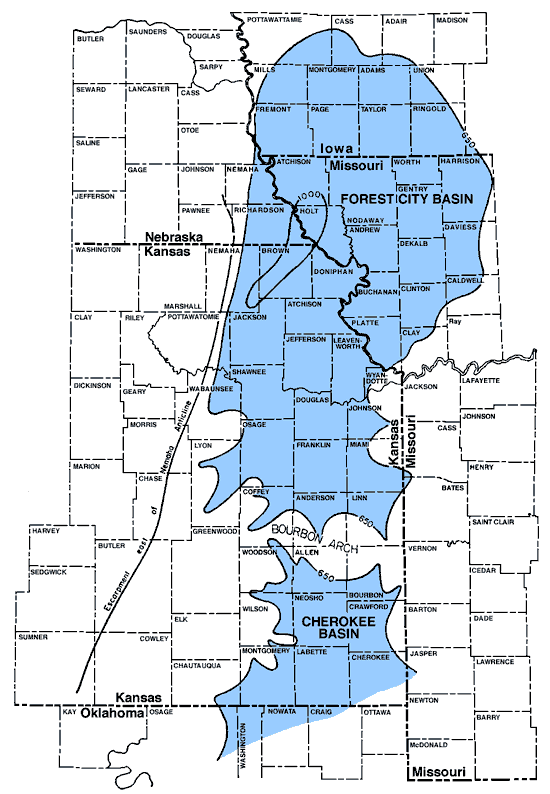
The Forest City basin, the subject of this report, was originally both a structural and a topographic basin (Figure 1). It did not come into existence until after Mississippian time. The surface of the whole region had been raised, with gentle folding, at the end of Mississippian deposition in Kansas. The principal fold was the Nemaha anticline which extends across Kansas from southeastern Nebraska to central Oklahoma. The exposed rocks were then subjected to erosion for such a long period that the surface was worn down nearly to sea level, although locally there was some low relief. The rocks were again deformed before the advance of the Pennsylvanian sea over the area. The beveled crest of the Nemaha anticline was re-elevated, probably with faulting along its eastern side, and the peneplaned surface of the Mississippian rocks east of the fold was warped downward to form a great basin in the adjoining areas of Kansas, Missouri, Iowa, and Nebraska. This depressed area constitutes the Forest City basin. When the region was invaded by the Pennsylvanian sea, thicker deposits accumulated in this basin than on the higher lands surrounding it. The extent and thickness of these deposits are the measure of the extent and depth of the basin.
Figure 1--Map showing outline of the Forest City basin and its relation to the northern end of the Cherokee basin and to the escarpment on the east side of the Nemaha anticline. The basins are outlines by a contour indicating a thickness of 650 feet between the base of the Hertha limestone and the top of the the Mississippian limestone. The deepest part of the basin is outlined by the 1000-foot thickness contour. Data for northeastern Kansas are adapted from figures 17 and 18 of this report; for Missouri in part after McQueen and Greene (1938, pl. 4); for southeastern Kansas after Bass (1936, pl. 1); and for Iowa and Nebraska after Holl (1932). A larger version of this figure is available.
The Forest City basin had a relatively brief existence. It was formed by the warping of the post-Mississippian peneplain, and was united with the similarly formed Cherokee basin when the low divide separating them was covered by the accumulating deposits of the Cherokee shale, the earliest formation of Pennsylvanian age in Kansas.
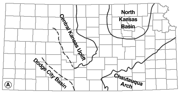
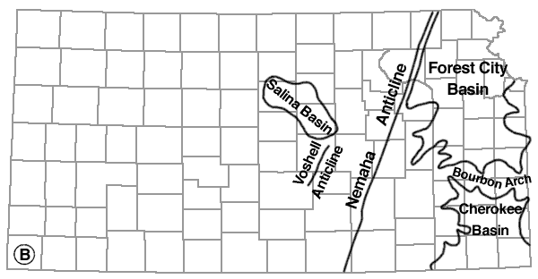
Figure 2 shows the principal structural features of Kansas which were not all developed at the same time. The North Kansas basin was developed contemporaneously with the Chautauqua arch in southeastern Kansas, the Ozark uplift of Missouri, and probably the Central Kansas uplift. In post-Mississippian time the Nemaha anticline, the Voshell anticline, the Salina basin, and an unnamed structural basin along Missouri river northwest of Kansas City were probably developed more or less contemporaneously (fig. 2B). The Forest City basin and the Cherokee basin belong to the same general period, but they were not developed in their final form until the rejuvenation of the Nemaha anticline and the warping of the post-Mississippian peneplain occurred.
Figure 2--Maps showing the outlines of the principal structural features of central and eastern Kansas. The Chautauqua arch, Central Kansas uplift, North Kansas basin, and Dodge City basin, shown in figure 2A, were developed before Mississippian time. The Nemaha anticline, Voshell anticline, Salina basin, Forest City basin, and Cherokee basin, shown on figure 2B, were developed mainly after Mississippian time.
The Chautauqua arch is indicated by outcrops of the top of the Simpson sandstone on the pre-Chattanooga surface (after McClellan, 1930); trends of the Nemaha and Voshell anticlines and the deepest part of the Salina basin are shown on the thickness map of Mississippian limestones (after Lee, 1939, pl. 1); Central Kansas uplift is shown by the area in which Mississippian limestone is absent; Cherokee basin is outlined from thickness map of Cherokee shale by N. W. Bass (1936, pl. 1); North Kansas basin of John L. Rich is outlined from thickness map of Chattanooga shale (Lee, 1940, pl. 3); Dodge City basin after McClellan (1930); and Forest City basin from figure 17 of this report.


The study of the Forest City basin in Kansas has been made easier by the fact that most of the holes in the area were drilled with cable tools, which has made it possible to study the rocks represented by the samples without the contamination of cuttings from overlying rocks usual in samples from rotary wells.
Complete sets of samples from all of the recent wells and from many of the older wells were collected and studied and have been placed on file at the State Geological Survey at the University of Kansas in Lawrence. The abundance of sample material from the McLouth pool has shed much light on the conditions of accumulation of gas in the Pennsylvanian rocks in northeastern Kansas. In the McLouth field, however, only a few wells have been drilled below the upper part of the Mississippian, and only two have reached the Arbuckle limestone.
Terminology
Inasmuch as there is no standardized use of words for describing some of the textures of rock materials and insoluble residues, it is desirable to explain the meaning intended for certain adjectives used in this report.
Cotton rock is a soft porous siliceous rock or insoluble residue composed of white, opaque, uncemented microscopic particles of silica.
Dolocast is a term introduced by McQueen (1931, pp. 8,9) for the impression left by a dolomite crystal removed from chert or other materials in the insoluble residues. Dolocasts may occur singly or be so numerous that they form a porous or spongy texture.
Drusy texture is applied to deposits of crystalline quartz originally in microscopic cavities.
Even-textured rock has a homogeneous character and is microscopically massive.
Grainy texture consists of microscopic crystals of limestone or dolomite or particles of silt sparsely distributed in a dull opaque usually calcareous matrix. The matrix in some rocks is cryptocrystalline, in others earthy. By decrease of the calcareous matrix this texture may become sucrose dolomite or silty limestone.
Hackly texture is applied to deposits of broken or vesicular quartz with few or no crystalline faces.
Matted texture is composed of closely packed fragments of silicified microfossils and sponge spicules cemented in a siliceous matrix.
Mottled texture is composed of parti-colored chert in patches without sharp margins; it is microscopic, but much coarser than a stippled texture. Porous texture is used for aggregates of quartz or chert or other materials in which the individual cavities are microscopic.
Semigranular texture consists of coarsely crystalline grains, principally fossil fragments, in a microcrystalline matrix. In some rocks crinoidal limestones are semigranular.
Spongy texture refers to aggregates of quartz, chert, silt, or clay in insoluble residues from which the soluble matrix has been removed. The individual openings are submicroscopic.
Stippled texture has a stippled pattern on a smoothly broken chert surface due to the complete replacement by silica of rocks having grainy texture. The sharp outline of the replaced impurities is blurred in some zones, giving a cloudy margin to the dots.
Streaked texture has microfossiliferous fragments of matted chert imperfectly replaced or subsequently modified; consequently the outlines of the inclusions are blurred.
Sucrose texture consists of microscopically coarse or fine crystals--usually dolomite--packed closely (without matrix) like the grains of lump sugar.
Acknowledgments
The collection of samples from the McLouth pool has been aided by the drillers, contractors, and operators in the field, without whose collective help much of the information could not have been assembled; to them the writer extends his thanks and appreciation. Most of the drillers have recognized the value of keeping careful and accurate logs. These records have been valuable for although the microscope reveals many characteristics of the rocks which are not visible to the naked eye, many contacts, such as those between limestone and shale, can be determined more accurately by the driller than by the geologist working with samples only.
The identification of the tops of formations of pre-St. Peter age in the few wells drilled below the St. Peter in the area is the work of R. P. Keroher, assisted by Jewell Kirby. Outcrops of all the Devonian formations in northern Missouri and Iowa were visited and sampled in company with R. C. Moore, and in Iowa with H. G. Hershey of the Iowa Geological Survey.
Thanks are due to H. S. McQueen of the Missouri Geological Survey for samples of some wells in northwestern Missouri and for sample determinations of other Missouri wells against which the lithologic criterion of northeastern Kansas were checked.
Many other persons have contributed directly and indirectly to the investigation. Dalton B. Stover, James Clark, Eugene Maxwell, Hugh Crain, and Philip Kaiser at various periods collected samples and logs that provided complete and reliable information on wells as they were drilled. The samples were prepared and the residues made by the staff of the subsurface laboratory of the State Geological Survey of Kansas. Much of the microscopic work on the Pennsylvanian rocks, particularly in the McLouth field, was done by Thomas G. Payne. The manuscript was read by H. D. Miser, John C. Frye, and J. M. Jewett.
Prev Page--Table of Contents || Next Page--Stratigraphy--Cambrian
Kansas Geological Survey, Forest City Basin
Comments to webadmin@kgs.ku.edu
Web version July 2005. Original publication date Dec. 1943.
URL=http://www.kgs.ku.edu/Publications/Bulletins/51/02_intro.html
