![]()
Use your "Back..." button to return to the page you were viewing.
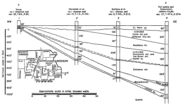
Figure 5--Cross section from west to east on line C-D (see also fig.. 10) from Pottawatomie County, Kansas, to Jackson County, Missouri, showing structural relations of St. Peter sandstone to pre-St. Peter rocks. The chief unconformaties are at the base of the Lamotte, Potosi, Van Buren, Roubidoux, and St. Peter formations. Formational boundaries of well No. 1 by Wallace Lee and R.P. Keroher, State Geological Survey of Kansas; and well No. 4 by H.S. McQueen, Missouri Geological Survey. A larger version of this figure is available as an Acrobat PDF file (128 KB).
Use your "Back..." button to return to the page you were viewing.
Kansas Geological Survey, Forest City Basin
Comments to webadmin@kgs.ku.edu
Web version July 2005. Original publication date Dec. 1943.
URL=http://www.kgs.ku.edu/Publications/Bulletins/51/fig5.html