Kansas Geological Survey, Bulletin 41, Part 2, originally published in 1942
with a chapter on
Prepared by the State Geological Survey of Kansas and the United States Geological Survey, with the cooperation of the Division of Sanitation of the Kansas State Board of Health and the Division of Water Resources of the Kansas State Board of Agriculture.
Originally published in 1942 as Kansas Geological Survey Bulletin 41, Part 2. This is, in general, the original text as published. The information has not been updated. An Acrobat PDF version of the bulletin (8 MB) is also available.
Because of the present national emergency, scores of new industrial plants for the manufacture of essential war materials are being erected in many parts of the country, and plans are under way for many more. Kansas is the home of several important defense enterprises, including large airplane factories at Wichita and large ordnance plants now nearing completion at Parsons and Pittsburg. A huge munitions plant is being started just east of Eudora, between Lawrence and Kansas City. Large army bases are situated at Fort Leavenworth and Fort Riley, and important air force facilities are being planned near Topeka and in Johnson County.
Among the essential requirements of areas suitable for the location of national defense industries are the following: (1) safety from enemy attack in wartime, (2) a water supply of the required quantity and quality, (3) near-by sources of electric power or fuel or both, (4) proximity to adequate rail-transportation facilities, and (5) availability of areas of flat land suitable for the erection of factories and attendant facilities. In addition to the above essential requirements, some national defense industries must be located near sources of certain mineral deposits or other raw materials.
Many areas in Kansas satisfy part or all of the requirements listed above. Inasmuch as Kansas contains the geographical center of the United States, it is safer from enemy attack in wartime than most parts of the country. As described in the present report, large supplies of water, adequate in quantity and satisfactory in quality, for various national defense plants are available in many parts of Kansas, either from wells or from streams, using regulatory storage. Large coal, oil, and gas fields within the state provide an abundance of cheap fuel, and electric power lines reach most parts of the state. A network of railroads and modern highways traverse the state and provides excellent transportation facilities. Kansas contains vast areas of flat or nearly flat land that are well suited for industrial development. As the seventh leading mineral producer among the 48 states, Kansas is well endowed with mineral resources many of which are vital to national defense. These resources, in order by value of annual production, include petroleum, natural gas, natural gas-gasoline, zinc, coal, cement, stone, salt, lead, clay products, sand and gravel, gypsum, chats, volcanic ash, and native asphalt. These resources and their availability will be described in a forthcoming publication of the Geological Survey entitled "Kansas Mineral Resources for National Defense."
Raymond C. Moore
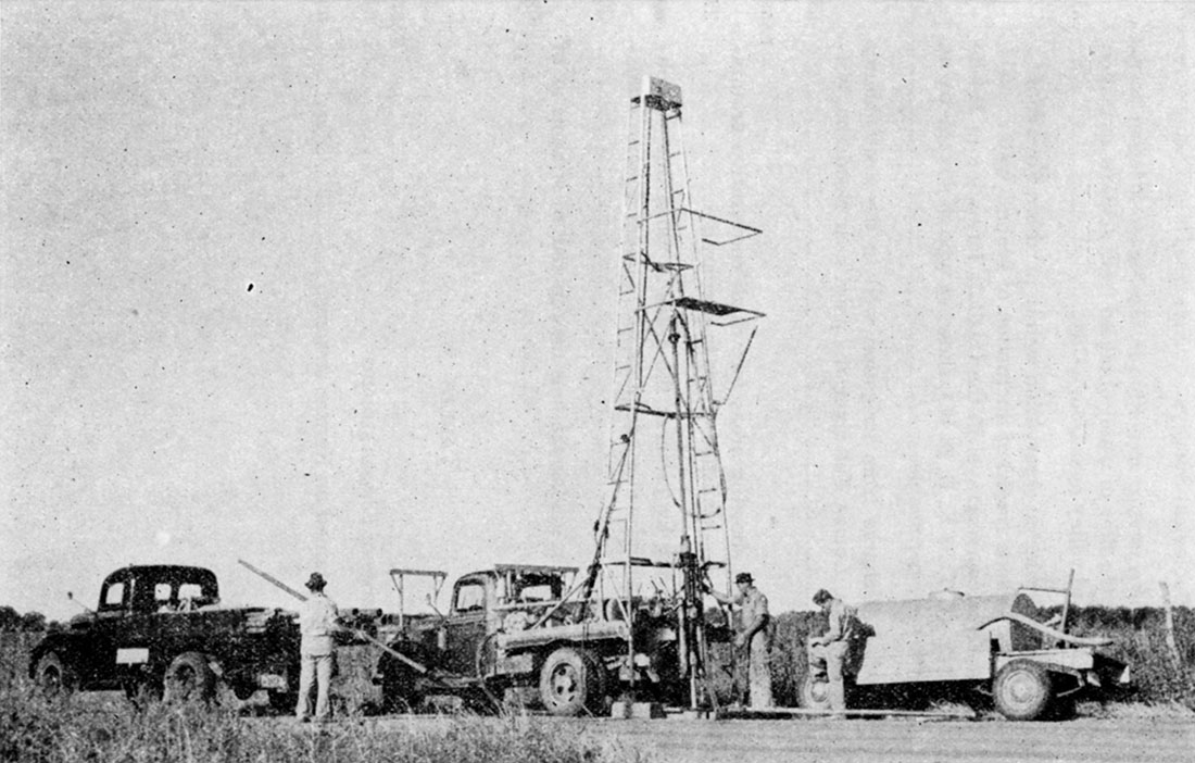
Plate 1—Portable hydraulic-rotary drilling machine owned and operated by the State and Federal Geological Surveys. This is an invaluable tool for study of the ground waters of Kansas. (Photo by Oren Bingham)
This report calls timely attention to the availability in many parts of Kansas of large supplies of water from wells or from streams for use by national defense industries.
It also summarizes the quality of water from wells in different parts of the state, with reference to suitability for industrial use.
Supplies of 10,000,000 to more than 20,000,000 gallons a day are available for -eontinued use from groups of wells in the Missouri, Kansas and Arkansas river valleys, and somewhat smaller supplies are available in many other parts of the state, particularly in the western part. Supplies larger than those stated are available for a period of a few years during the present emergency. Information is given regarding parts of the state in which ground-water supplies large enough for use by national defense plants generally are not available.
Since July 1937 an extensive program of ground-water investigations in Kansas has been conducted by the State Geological Survey of Kansas and the Geological Survey of the United States Department of the Interior, in cooperation with the Division of Sanitation of the Kansas State Board of Health and the Division of Water Resources of the Kansas State Board of Agriculture. The areas of Kansas studied to date and the status of reports on these areas are shown in figure 1.
The following ground-water reports were published in 1940: a preliminary report on the "Equus beds" area, comprising parts of McPherson, Harvey, Sedgwick, and Reno counties (Lohman and Frye, 1940); a report on the ground-water resources of the entire state (Moore, 1940); and a preliminary report on the Meade artesian basin (Frye, 1940). The investigation in the "Equus beds" area was financed in part by the city of Wichita, and led to the development of a new ground-water supply for the city that was put in operation on September 1, 1940. In 1941 a detailed report on Stanton County (Latta, 1941) appeared, and the following brief reports were published: ground-water conditions in the vicinity of Lawrence (Lohman, 1941); reconnaissance of ground-water resources in Atchison County (Frye, 1941); and a report pertaining to ground-water supplies from deep wells in southeastern Kansas (Abernathy, 1941).
Figure 1—Index map of Kansas showing areas for which cooperative ground-water reports have been published or are in preparation. Bulletin numbers of ground-water reports published by State Geological Survey of Kansas are indicated. Information on ground-water conditions in all parts of the state is contained in Bulletin 27; and Bulletin 38, part 8, contains information on the southeastern deep water area (9).
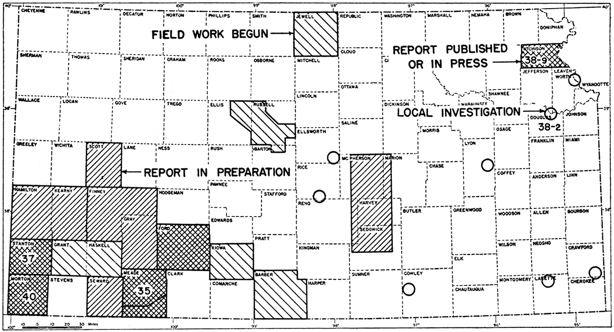
Reports on Morton County (McLaughlin, 1942) and on water supplies in south-central Kansas (Lohman, 1942) were published early in 1942, and reports on Ford County, by H. A. Waite, and Meade County, by J. C. Frye, are nearly ready for the press. Ground-water reports for the following areas are in active preparation: Hamilton and Kearny counties, by T. G. McLaughlin; Finney and Gray counties, by B. F. Latta; Scott County, by H. A. Waite; Seward County, by Frank Byrne; and the "Equus beds" area, by S. W. Lohman, J. C. Frye, and C. C. Williams. In 1941, ground-water studies were begun in the following areas: Russell and Ellis counties, by J. C. Frye and J. J. Brazil; Kiowa County, by B. F. Latta; Grant and Haskell counties, by T. G. McLaughlin; Jewell County, by V. C. Fishel and H. A. Waite; Barber County, by Frank Byrne; and studies were made in the vicinity of Parsons by G. E. Abernathy and C. C. Williams.
In addition to the investigations at Lawrence and Parsons noted above, local investigations, shown in figure 1 by circles, were made for the state penitentiary at Lansing, for industrial developments near Pittsburg, and for the cities of Reading, Sterling, Langley, and Winfield.
Of special importance in ground-water investigations is the periodic measurement of water levels in numerous observation wells in each of the areas being studied, in order to determine the magnitude and character of water-level fluctuations and the rate at which the underground reservoirs are replenished by rainfall or depleted by natural processes or by heavy pumping. The cooperating state and federal agencies now obtain accurate records of water-level fluctuations in nearly 500 observation wells situated in 25 counties of central and western Kansas (pl. 3). The descriptions of the observation wells and the measured water levels are published in the annual water-level reports of the Geological Survey, United States Department of the Interior (U.S. GeoI. Survey Water-Supply Papers 840, 845, 886, and 908). The annual water-level report for 1941 is now in preparation. It is planned to continue the water-level program in Kansas as long as possible and to establish observation wells in additional counties from year to year, inasmuch as the ultimate value of periodic observations of ground-water levels is in direct proportion to the length and continuity of the record.
The present report is intended to call timely attention to the availability in Kansas of large water supplies, from wells and from streams, that are of satisfactory chemical quality for use by many national defense industries. The report calls attention only to the broader water-supply features of the state. For specific details of ground-water conditions in particular parts of the state, interested persons are referred to the bulletins on ground water indicated in figure 1 and discussed above, and to the offices of the State and Federal Geological Surveys at Lawrence. A portable hydraulic-rotary drilling machine owned and operated by the State and Federal Geological Surveys (pl. 1) is an invaluable tool for study of the ground waters of Kansas, and is used for putting down test holes in each of the areas studied. There are available at the above-mentioned offices the logs of many wells and test holes, the records of hundreds of drilled wells, and analyses of typical well waters from many parts of the state. Additional analyses of both ground and surface waters are available at the office of the Division of Sanitation of the Kansas State Board of Health, at Lawrence. Information on stream flow in Kansas is obtainable from the offices of the Division of Water Resources of the Kansas State Board of Agriculture, in Topeka, or the United States Geological Survey, at Topeka. Information pertaining to availability of coal, oil, gas, and other mineral resources of Kansas may be obtained from the office of the State Geological Survey of Kansas, at Lawrence.
This report has been reviewed by R. C. Moore, state geologist, and T. G. Payne, editor, of the State Geological Survey of Kansas; by George S. Knapp, chief engineer of the Division of Water Resources of the Kansas State Board of Agriculture; by L. A. Young, acting director of the Division of Sanitation of the Kansas State Board of Health; and by O. E. Meinzer, geologist in charge of the Division of Ground Water of the Federal Geological Survey. Figure 2 was drawn by G. W. Reimer, draftsman of the State Geological Survey. The Kansas State Board of Health kindly supplied information in regard to public water supplies of many Kansas cities. R. O. Joslyn, president of the Layne-Western Company, Kansas City, Missouri, kindly supplied information pertaining to wells drilled by his company in several parts of Kansas.
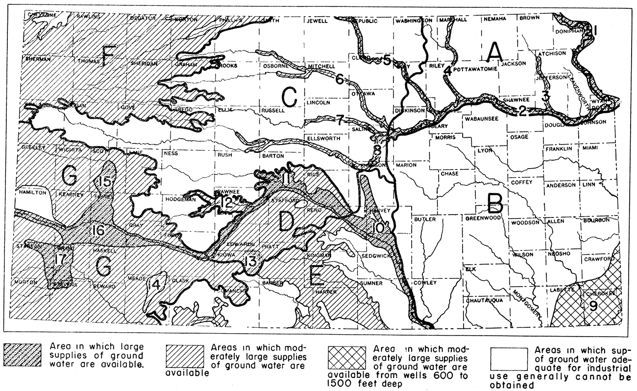
The rock materials that underlie the surface of Kansas yield water more freely in some parts of the state than in other parts. Beds of coarse gravel and sand that fill the larger stream valleys yield large supplies of water to wells, whereas some of the fine-grained or tightly-cemented rocks that underlie large areas of the state yield very little water to wells. The general areas of the state in which are available supplies of ground water adequate for national defense industries are shown in figure 2. The general ground-water regions designated by letters in figure 2 are adapted in part.from Moore (1940, p. 49). Areas designated by letters or by numbers are discussed separately in the following pages; and, for the convenience of the reader, the letters and numbers are included in the appropriate headings both in the table of contents and in the text. The flows of the larger rivers are given in table 1.
Figure 2—Map of Kansas showing by patterns the areas in which may be obtained supplies of ground water adequate for national defense industries. Areas designated by letters or numbers are discussed separately in the text.
The Missouri river valley is the boundary between Kansas and Missouri from the Nebraska state line southward to Kansas City. Alluvium occurs below the surface of most of the broad, flat valley, and in most places it contains thick beds of permeable sand and gravel. Detailed study has not been made of this part of the valley except near Lansing, Leavenworth County, where test drilling was done by the State and Federal Surveys in cooperation with the State Board of Health (unpublished report, "Memorandum in regard to prospecting for a softer water supply for the Kansas State Penitentiary at Lansing, Kansas," by S. W. Lohman and Alexander Mitchell). The maximum thickness of alluvium encountered in this test drilling was 81 feet.
In most parts of the Missouri valley a yield of as much as 1,000 gallons a minute may be obtained from a properly constructed drilled well employing gravel packing. According to R. O. Joslyn, president of Layne-Western Company, Kansas City, Missouri (personal communication, February 1942), the specific capacity of most industrial wells in this part of the Missouri river valley is about 100 gallons a minute for each foot of draw-down. Mr. Joslyn also stated that individual industries at Kansas City pumped as much as 9,000,000 gallons a day from wells, indicating that the aggregate industrial pumpage in and near Kansas City probably is very large. Available data indicate that ground-water supplies as large as 25,000,000 gallons a day are available to national defense industries from local areas in most parts of the Missouri river valley, and that much larger quantities of water would be available for a period of a few years during the present emergency, or for fire protection.
Water from wells in the Missouri valley generally is very hard and contains considerable iron; it is therefore not suitable for certain industrial uses unless it is treated. The hardness of the water ranges from 400 to more than 800 parts per million, but is nearly all carbonate hardness. The waters contain from 5 to more than 25 parts per million of iron and generally contain a considerable amount of free carbon dioxide. Treatment of these waters for reduction of hardness and removal of iron and carbon dioxide, however, is relatively simple.
The Kansas (Kaw) river valley extends in a general east-west direction from the confluence of the Republican and Smoky Hill rivers at Junction City to the Missouri river at Kansas City. Only the main channel of the river between these two cities is discussed here; the larger tributary streams are considered separately in the pages that follow.
Detailed study of the ground-water conditions in the Kansas river valley has been made only in the vicinity of Lawrence (Lohman, 1941), but this study serves to illustrate general conditions in the valley. The inner valley of Kansas river is 2 to 4 miles wide in most places, and at some places it is somewhat wider. A series of test holes put down across the valley at Lawrence indicates a maximum of about 80 feet of alluvium, but remnants of old river terraces indicate that at one time the valley was filled with alluvium to a greater height and width (Lohman, 1941, pp. 26-33). The alluvium generally is more than 40 feet thick and contains thick beds of coarse gravel and sand that are very permeable. In most parts of the valley a properly constructed drilled well will yield about 1,000 gallons a minute with a draw-down of 8 to 12 feet, and in favorable areas where the alluvium attains its maximum thickness it is possible that somewhat larger yields could be obtained.
Ground-water supplies of 10,000,000 to 20,000,000 gallons a day are obtainable for national defense industries in most parts of the valley, the largest supplies being available in favorable areas near the river where recharge from the river can take place under conditions of heavy pumping. Larger quantities than these would be available for a period of a few years during the present emergency, but continuous pumping of larger quantities would entail careful planning, widespread distribution of wells, and continued observation of water levels.
Available analyses indicate that water in the alluvium of the Kansas river valley is very hard, containing 300 to more than 900 parts per million of hardness. Most of the hardness, however, is in the form of carbonate, or so-called temporary hardness. The water generally contains very little chloride. Some of the waters contain a considerable amount of free carbon dioxide. Most of the waters contain iron in amounts sufficient to produce a reddish sediment on exposure to air, and a few of the waters contain 10 to nearly 50 parts per million of iron. Some of the waters contain appreciable quantities of manganese. Water of this character generally requires treatment for most industrial uses, but such treatment is relatively simple because of the low content of non-carbonate hardness.
The Big Blue river enters Kansas in Marshall County, flows southward along the boundary between Riley and Pottawatomie counties, and flows into Kansas river near Manhattan. The Big Blue river valley is about a mile wide in most places, and is underlain by alluvium containing beds of gravel and coarse sand. Four wells in the alluvium, near the mouth of the valley, supply Manhattan with more than 1,000,000 gallons of water daily. The water from individual wells at Manhattan ranges in total hardness from 421 to 547 parts per million. The chloride content of the water is low, but the water contains about 10 parts per million of iron.
Continuous supplies of 1,000,000 to 5,000,000 gallons a day are available from wells at selected places along the Big Blue valley, and somewhat larger supplies probably could be obtained by distributing many wells along the river so as to take full advantage of percolation from the river under conditions of heavy pumping. Supplies of more than 5,000,000 gallons daily would be available in favorable areas for a period of a few years during the present emergency.
The south fork of Republican river crosses Cheyenne County and unites with the north fork of Republican river in Nebraska. The main river enters Kansas in the northeastern corner of Jewell County, passes through Republic, Cloud, and Clay counties, and flows into Kansas river at Junction City, in Geary County. Only the main valley of the river ending at Junction City will be considered here.
Information on the geology of part of the Republican river valley has been published (Wing, 1930; Jewett, 1941), but no study has been made of the ground-water conditions in the valley. The flood plain of the valley ranges in width from 2 to 3 miles. The alluvium filling the valley comprises beds of silt, sand, and gravel and ranges in thickness up to about 60 feet. A few municipal and irrigation wells and many domestic and stock wells in the valley obtain abundant supplies of water. Properly constructed wells in favorable areas yield 500 to 1,000 gallons a minute with nominal drawdown.
Supplies as large as 5,000,000 gallons a day probably could be pumped from groups of wells in favorable areas of the valley, and somewhat larger supplies would be available for a period of a few years during the present emergency.
The water from municipal wells at Concordia and Clay Center has a hardness of 316 to 524 parts per million (mostly carbonate hardness), and contains 1 to 2 parts of iron and 34 to 97 parts of chloride.
The Smoky Hill river flows from west to east through the third tier of counties south of the Nebraska state line, from Wallace County through Russell County, thence across Ellsworth, McPherson, Saline, and Dickinson counties to its junction with the Republican river in Geary County. Data concerning the geology of parts of the Smoky Hill valley have been published (Rubey and Bass, 1925; Bass, 1926; Elias, 1931; and Jewett, 1941), and studies are now in progress in McPherson, Ellsworth and Russell counties. The Smoky Hill river flows through important agricultural and stock-raising districts, and several industrial cities are situated along its banks. Oil and gas resources and deposits of clay, building stone, chalk, salt, and sand and gravel are located along this valley.
Ground water in the Smoky Hill river valley ranges in hardness from 250 to more than 600 parts per million, most of which is carbonate hardness. In most parts of the valley the water contains very little chloride, but locally it contains considerable chloride. Most of the ground waters contain but little iron; a few, however, contain as much as 20 parts per million of iron.
Water occurs in the sand and gravel of the alluvium underlying the flood plain of the river, in the Pleistocene terrace sands and gravels bordering the flood plain, and locally in Cretaceous sandstones that underlie the alluvium and terrace deposits. At many localities along the eastern half of the Smoky Hill valley, particularly east of Ellsworth County, yields of 1,000 gallons a minute or more are obtainable. A well near Abilene has a reported yield of 4,000 gallons a minute; several city wells at Salina yield 1,000 gallons a minute each. One of the municipal wells at Solomon yields 200 gallons a minute with a draw-down of 6 feet. Supplies of 5,000,000 to 10,000,000 gallons a day could be developed from wells in the alluvium at selected places in the valley eastward from Lindsborg, and supplies of 1,000,000 to 5,000.000 gallons a day probably could be developed at some places in the western part of the valley.
In this report ground-water supplies along the Arkansas river valley are discussed separately for the eastern Arkansas river valley (10), the central Arkansas river valley (11), and the western Arkansas river valley (16). The part of the valley between Hutchinson and the Oklahoma state line is designated as the eastern Arkansas river valley. The availability of ground-water supplies for national defense plants along this eastern section of the valley and along the McPherson filled valley north of Halstead has been described in a separate report (Lohman, 1942), to which the reader is referred. Additional information on the geology and groundwater resources of the northern part of this eastern area is contained in an earlier report (Lohman and Frye, 1940), and a detailed report on the same part of the area is now in preparation (fig. 1).
The central Arkansas river valley may be considered as that part of the valley between Kinsley and Hutchinson. It extends through important agricultural and stock-raising districts and contains several industrial cities. The valley is an important producing area for oil and gas, salt, and sand and gravel.
The valley comprises a wide band of alluvium that lies mainly north of the river. The alluvium, which is more than 100 feet thick in some places, contains beds of permeable water-bearing sand and gravel. Wells yielding 1,000 to 1,500 gallons a minute can be developed at many places along the central Arkansas river valley. Individual municipal wells at Great Bend and Hutchinson yield 1,000 to 1,500 gallons a minute, and a municipal well at Kinsley is pumped at the rate of 600 gallons a minute. Supplies of 10,000,000 to 20,000,000 gallons a day could be developed from wells in local areas, and in favorable areas larger supplies could be developed by widespread distribution of wells to take full advantage of percolation from the river. Larger supplies would be available for a period of a few years during the present emergency.
Ground water in the Arkansas valley upstream from the mouth of Rattlesnake creek contains less chloride than ground water farther downstream, inasmuch as Rattlesnake creek drains an area of salt marshes. Thus, at Kinsley the chloride content of the ground water is only 2 parts per million, at Great Bend 86 parts, and at Ellinwood 83 parts; whereas at Hutchinson it is from 100 to more than 600 parts. The total hardness of ground water at Kinsley, Great Bend, and Ellinwood ranges from 126 to 272 parts per million and is mostly carbonate hardness. The water from municipal wells at Hutchinson ranges in total hardness from 134 to 593 parts per million, much of which is non-carbonate hardness. Ground waters in most parts of the central Arkansas river valley seem to have a low content of iron.
The Kiowa County area comprises the part of eastern Kiowa County that lies north of Medicine Lodge river. Information on this area was obtained during the summer of 1941 in a cooperative investigation by Bruce F. Latta of the geology and ground-water resources of Kiowa County (fig. 1). A report on this work will be published later as a bulletin of the State Geological Survey of Kansas. Supplies of oil, gas, gypsum, salt, volcanic ash, and sand and gravel are readily accessible to this area.
The surface of the Kiowa County area is flat to gently rolling and in the northern part is covered by low sand dunes. The area is underlain by unconsolidated silts, sands, and gravels of Quaternary age that are locally nearly 300 feet thick. The Quaternary deposits are underlain by Cretaceous shales. In the Quaternary deposits vertical and lateral gradations from one lithologic type to another may take place within relatively short distances. The aggregate thickness of saturated sand and gravel penetrated in 4 test holes in this area ranges from about 75 to about 175 feet. The saturated material ranges in texture from fine sand to very coarse gravel.
Existing wells in the area are used mostly for stock and domestic purpose and range in depth from 25 to 160 feet. The depth to water level ranges from 17 to 120 feet. In the southern part of the Kiowa County area, where tributaries of Medicine Lodge river have cut their valleys down to the water table, there are several springs and spring areas. The total discharge of these springs amounts to more than 16,000,000 gallons a day.
Although at the present time there are in this area no wells from which large supplies of water are being pumped, the thickness and permeable character of the water-bearing deposits and the existence of large springs indicate that large supplies of ground water for industrial use could be obtained from properly constructed wells tapping the Quaternary sands and gravels. Supplies of more than 5,000,000 gallons a day could be developed continuously from favorable parts of this area, and larger supplies would be available for a period of a few years during the present emergency. Because of the varying character of the deposits, preliminary test drilling would be essential in locating sites for individual wells.
Analyses of waters from representative wells and springs in the Kiowa County area indicate that the waters contain 136 to 295 parts per million of dissolved solids and have a hardness of 114 to 244 parts. The content of iron and fluoride in these waters is low, less than 0.5 part per million in most of the waters analyzed.
The Scott-Finney shallow water basin is situated in south-central Scott County and extends southward to the Arkansas valley in Finney County. It is termed a shallow water basin because ground water is obtained at depths ranging from 10 to 90 feet and because there is no surface drainage from the basin. The land surface in general is smooth and nearly flat, and the region is characterized by many shallow undrained basins. A report on the geology and ground-water resources of Scott County, by H. A. Waite, and a report on the geology and ground-water resources of Finney and Gray counties, by B. F. Latta, are now in preparation and will be published as bulletins of the State Geological Survey of Kansas.
The Shallow Water oil field is situated in the basin south of the city of Shallow Water. There are two gas wells in southeastern Kearny County, just south of the basin, and the Hugoton gas field is situated to the south of the basin. There also are supplies of sand and gravel, stone, caliche, and chalk adjacent to the basin.
Most of the wells in the shallow water basin penetrate deposits of Tertiary and Quaternary age that are composed of, complexly interbedded lenses of clay, silt, sand, and gravel. The deposits range in thickness from about 50 to 350 feet.
The wells range in depth from about 60 feet in the lowest part of the basin in Scott County to about 340 feet just north of the Arkansas valley in Finney County. In 1941 there were approximately 140 irrigation wells in the basin, of which about 100 were in Scott County and about 40 in Finney County. Most of those in Finney County are situated within 4 or 5 miles of the Arkansas valley, but the number of well installations in the northern part of the County is increasing gradually.
The yields of individual wells in the shallow water basin range from about 500 to 2,900 gallons a minute, and the draw-downs range from about 13 to 50 feet. One well, situated 2.5 miles west of Shallow Water, had a measured yield of 2,900 gallons a minute with a draw-down of 30.7 feet (pl. 4). This well had the largest yield of all the wells in Scott County that were tested.
The irrigated acreage in that part of the shallow water basin in Scott County has increased steadily from 1,021 acres in 1932 to 17,200 acres in 1940, when a total of about 17,700 acre feet of water was pumped from irrigation wells. A continuous record of the water level in an observation well in the shallow water basin in Scott County has shown that during the 10-year period of record from October 1931 through December 1941 there has been a net decline in water level of 4.65 feet, which represents an average annual decline of 0.51 foot. The relation of this decline in water level to the increased withdrawal of ground water for irrigation and to the deficient precipitation during the 10-year period has been described (Waite, 1941).
As indicated above, the withdrawal of ground water from the Scott-county part of the shallow water basin alone amounted to 17,700 acre feet of water in 1940, or an average withdrawal of 15,800,000 gallons a day. This pumpage, however, occurred during the irrigation season, principally during the period from May through November; hence the actual daily pumpage during the irrigation season amounted to much more than 15,800,000 gallons. In addition to the quantity of water now being pumped for irrigation, supplies of 2,000,000 to more than 5,000,000 gallons a day are available from wells in favorable parts of the basin, and larger supplies would be available for a period of a few years during the present emergency. Continuous withdrawal of large quantities of water from local areas in the basin, however, would interfere seriously with the rights of existing ground-water developments, and might endanger the permanence of the ground-water reservoir.
The hardness of 12 samples of water obtained from representative wells in the Scott-Finney shallow water basin ranges from 172 to 265 parts per million, most of which is carbonate hardness. Eleven of the samples contained from 1.0 part to 2.8 parts per million of fluoride, but one sample contained less than 1.0 part. All of the waters analyzed contained practically no iron, and most of the samples contained less than 50 parts per million of chloride. A few samples, however, contained as much as 150 parts per million of chloride. Water of this quality is entirely satisfactory for most industrial uses.
The area here described comprises the part of the Arkansas valley that lies between the city of Kinsley in Edwards County and the Colorado state line. The western Arkansas river valley constitutes a long narrow belt ranging in width from three fourths of a mile to 10 or 15 miles and having an over-all length of approximately 160 miles. The maximum width is not known definitely because the terraces on the southern side of the valley are covered by dune sand. Detailed investigations of the geology and ground-water resources of Hamilton and Kearny counties have been made by T. G. McLaughlin; of Finney and Gray counties by Bruce F. Latta; and of Ford County by H. A. Waite. The results of these investigations will be published as bulletins of the State Geological Survey of Kansas.
In the western Arkansas river valley ground water occurs in the alluvial sand and gravel, in Pleistocene terrace gravels bordering the flood plains, and in underlying Quaternary and Tertiary deposits of sand and gravel. The aggregate thickness of these deposits ranges from a few feet in the narrowest part of the valley to more than 400 feet in the sand hills south of the valley. Cretaceous shales; limestones, and sandstones underlie the Quaternary and Tertiary deposits.
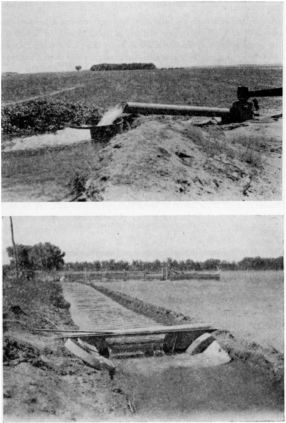
In the valley proper there are more than 500 irrigation wells that yield from less than 100 gallons a minute to about 4,000 gallons a minute, depending on the size, location, and type of well construction (pl. 2). The depths of the wells range from about 15 to nearly 300 feet, and the depth to the water level ranges from a few feet to about 20 feet below the land surface. Many of the pumping plants in the valley comprise one centrifugal pump connected to a battery of several shallow wells. A pumping plant situated about 2.5 miles southeast of Lakin is equipped with a 12-inch centrifugal pump powered by an electric motor and yields approximately 4,000 gallons a minute. The water from this plant is obtained from a battery of 6 wells, each about 43 feet deep, in which the static water level is about 15 feet below the land surface. Individual wells in the valley yield from a few gallons a minute to about 1,400 gallons a minute. A few wells tap not only the alluvial deposits but also the deeper Quaternary and Tertiary deposits.
Plate 2—Upper: Pumping water for irrigation in the Meade artesian basin. (Photo by J. C. Frye). Lower: Measuring the flow of water obtained from shallow irrigation wells in the Arkansas valley near Dodge City. (Photo by H. A. Waite).
Wells in the area covered by dune sand south of the river are from 30 to 100 feet in depth. The water level in this area ranges from about 25 to 90 feet below the surface. Inasmuch as this area is covered by sand hills, only a few irrigation wells have been drilled. An irrigation well in sec. 32, T. 25 S., R. 33 W., south of Garden City, yields about 700 gallons a minute.
More than 22,000,000,000 gallons of water a year, or an average of about 60,000,000 gallons a day, is pumped from the alluvium in the western Arkansas river valley for industrial and irrigation use. Most of this water is pumped during the irrigation season, from April through October. Most of the municipal water supplies in the valley are pumped from wells that tap the underlying Tertiary deposits. Additional pumping from the alluvium would not be warranted in parts of the valley where there is a concentration of irrigation wells, but there are areas in the valley containing only a few irrigation wells in which additional pumping would be feasible. Water supplies of 10,000,000 to 20,000,000 gallons a day probably could be obtained from the alluvium in favorable localities. Larger supplies would be available for a period of a few years during the present emergency. In addition, supplies of 5,000,000 to 10,000,000 gallons a day could be developed from the terrace deposits and the deeper Quaternary and Tertiary deposits without causing any damage to existing developments. Thus, by drawing from wells in the alluvium and also from wells in the older deposits beneath the alluvium and the sand hills, continuous supplies of as much as 30,000,000 gallons probably would be available at a few favorable areas in the valley where at present there is little or no pumping for irrigation.
According to available analyses, water from the alluvium contains 200 to 4,700 parts per million of total dissolved solids and ranges in hardness from about 200 to more than 2,200 parts. Most of the waters sampled from the alluvium contain less than 2 parts per million of iron and of fluoride. Most of the waters from the alluvium contain 50 to 150 parts per million of chloride, but a few contain less than 10 parts and a few contain nearly 300 parts. The greatest range in the hardness of water from the alluvium occurs in localities where there is a large amount of irrigation.
The water from deeper Quaternary and Tertiary sands and gravels and from terrace deposits is of much better quality than water from the alluvium and is used extensively for municipal supplies. The waters from these sources range in hardness from 150 to 300 parts per million, and contain 5 to 30 parts of chloride. The iron content of the waters is generally less than 2 parts per million, and the fluoride content is less than 1 part.
The Grant-Stanton shallow water basin includes the western half of Grant County, the eastern third of Stanton County, the northern part of Stevens County, and a small part of northeastern Morton County. The area is a relatively flat plain and is drained by Cimarron river and its tributaries. The maximum local relief of about 125 feet is in southern Grant County along Cimarron river.
The parts of the shallow water basin that lie in Stanton and Morton counties have been described in bulletins of the Kansas Geological Survey (Latta, 1941; McLaughlin, 1942). Field work on the geology and ground-water resources of Grant and Haskell counties has been nearly completed by Thad G. McLaughlin, and a report on this work will be published later by the State Geological Survey of Kansas.
The southern half of the Grant-Stanton shallow water basin lies within the Hugoton gas field, from which is available an abundance of cheap fuel.
The Tertiary and Quaternary water-bearing materials that underlie the shallow water basin range in thickness from 200 feet in northern Stanton County to more than 500 feet in northern Stevens county. The material consists principally of silt, sand and gravel. Along the borders of the basin the material is mainly silt but contains some sand and gravel, and in the south-central part of the basin it is chiefly sand and gravel. In a large part of the basin the Tertiary and Quaternary water-bearing materials are underlain by Cretaceous sandstones that would yield additional supplies of water to deep wells.
Adequate water supplies for domestic and stock use are obtained from wells in the basin that range in depth from 50 to 150 feet. Larger supplies of water for irrigation use are obtained from wells that range in depth from 80 to 350 feet. The water table in the basin ranges in depth from about 35 to 110 feet below the land surface. In the stream valleys that traverse the basin the water table may be at the land surface or within 30 feet of the land surface.
At present there are about 20 irrigation wells in the GrantStanton shallow water basin. Descriptions of three of these wells are given in the following paragraphs.
The Winger irrigation well is at the NW corner, NE sec. 35, T. 27 S., R. 40 W. The well is 182 feet deep, is cased with 16-inch galvanized iron casing perforated from a depth of 62 feet to the bottom, and is gravel-packed. The water is obtained from sand and gravel. The water level in the well is reported to be about 63 feet below the land surface. The well is equipped with a turbine pump operated by a tractor and yields about 800 gallons a minute with a drawdown of 27 feet after pumping 6 hours.
The Jungferman irrigation well in the SE sec. 31, T. 27 S., R. 38 W., in northwestern Grant County, was drilled to a depth of 317 feet. The static water level is 57 feet. The well has a measured discharge of 1,197 gallons a minute with a draw-down of 24 feet after several days of pumping.
The Parsons well, in the northern part of Stevens County in sec. 4, T. 31 S., R. 37 W., was drilled to a depth of 300 feet. The depth to water level in this well is 94 feet. The water is obtained from coarse gravels of Tertiary and Quaternary age. The well is equipped with a turbine pump powered by two natural gas engines and is reported to yield 2,030 gallons a minute with a draw-down of 14 feet after several hours of pumping.
Available data indicate that large supplies of water could be obtained from the Grant-Stanton shallow water basin. Because the water resources of a large part of the basin are as yet undeveloped, additional development of new water supplies would not seriously endanger present irrigation supplies. A single well in this area, if properly situated and constructed, would yield as much as 3,000,000 gallons of water a day. Continuous supplies of 10,000,000 to 15,000,000 gallons a day could be developed from wells in favorable areas, and larger supplies would be available for a period of a few years during the present emergency.
Chemical analyses of water from wells in the Grant-Stanton shallow water basin indicate that the total hardness of the water ranges from 180 to 360 parts per million. Most of the ground waters are relatively free from iron, but some contain as much as 5 parts per million. As much as 3 parts per million of fluoride is found in the water from some wells. The underlying Cretaceous sandstones yield water of about the same quality as that from the Tertiary and Quaternary deposits, except that water from the Cretaceous beds generally contains more fluoride. Water from wells in the alluvium of the stream valleys is much harder and may contain as much as 1,400 parts per million of dissolved solids.
The areas treated in this section generally are less productive than those discussed above, but locally they may yield rather large supplies. Additional studies in these areas may reveal highly productive localities that should be classed with those described above.
The Delaware river heads in southern Brown County and eastern Jackson County, flows southward across western Atchison County, and joins Kansas river in Jefferson County. In the Delaware valley ground water is obtained from sandy out-wash and alluvium at depths of 25 to 75 feet. The depth to water level is less than 10 feet throughout much of the valley. Locally, between Muscotah and Arlington, ground water is under sufficient artesian pressure to cause it to rise in a pipe to a height of 8 feet or more above the land surface. Some data pertaining to that part of the Delaware valley in Atchison County has been published (Frye, 1941).
It is probable that yields of 200 to 300 gallons a minute or more could be obtained from properly located and constructed wells in this valley. Supplies of 1,000,000 gallons a day probably could be obtained from selected places along the valley, and larger supplies could be obtained for a period of a few years during the present emergency. Water obtained from sands of the Delaware river valley is of fairly good quality.
The north and south forks of Solomon river head in Thomas County and flow eastward to join in Mitchell County. The Solomon river joins Smoky Hill river at the Saline-Dickinson County line. The geology of parts of the area traversed by Solomon river has been described (Wing, 1930; Landes, 1930), but the ground-water resources of the valley have not been studied in detail.
In most places the alluvium in the Solomon river valley contains beds of water-bearing sand and gravel. Individual wells in favorable localities yield 500 to 700 gallons a minute. It seems probable that supplies of 2,000,000 to 3,000,000 gallons a day could be pumped from properly constructed wells in favorable areas, and larger supplies would be available for a period of a few years during the present emergency.
Waters from several municipal wells in the valley range in hardness from about 125 to more than 400 parts per million (chiefly carbonate hardness), and contain 20 to about 125 parts of chloride. Many of the ground waters contain very little iron, but a few contain 1 to 4 parts per million of iron.
The Saline river heads in Thomas County and flows eastward to its junction with Smoky Hill river in Saline County. It is roughly parallel to Smoky Hill river on the south and Solomon river on the north. Detailed descriptions of the geology of parts of the area traversed by the Saline river valley have been published (Rubey and Bass, 1925; Bass, 1926), and ground-water studies of the valley in Ellis and Russell counties are now in progress.
Ground water is obtained from sand and gravel of the alluvium underlying the flood plain, from terrace gravels along the sides of the valley, and locally from Cretaceous sandstones that occur below the alluvium and terrace deposits. Downstream from Lincoln, individual wells yield as much as 1,000 gallons a minute, and supplies of 2,000,000 to 3,000,000 gallons a day could be obtained in favorable areas. Larger supplies than this undoubtedly could be developed for a period of a few years during the present emergency. In the rest of the valley, upstream from Lincoln, the supplies available from wells are much smaller. In most places ground water in the Saline river valley is of fair quality, but locally it has a high content of chloride and is unfit for certain uses.
The southeastern deep water area comprises an area of about 2,000 square miles, mainly in Bourbon, Crawford, Cherokee, and Labette counties (fig. 2), in which moderately large supplies of ground water are available from deep wells. These counties adjoin the eastern and southern state boundaries of Kansas and comprise part of the lead and zinc mining district of southwestern Missouri, southeastern Kansas, and northeastern Oklahoma, this being known as the Tri-State district. A preliminary report on the ground-water resources of this area has been published (Abernathy, 1941). Information on the drilling and test-pumping of deep wells near Parsons and Pittsburg has been obtained by George E. Abernathy and Charles C. Williams, and will be incorporated in a forthcoming bulletin of the State Geological Survey of Kansas. The occurrence of ground water at shallow depths in this area is discussed under Southeastern region (B); the present section deals entirely with the availability of water from deep sources.
The principal water-bearing formations in the Tri-State district are, in ascending order: the Lamotte sandstone (Upper Cambrian); Roubidoux sandstone, Jefferson City dolomite, and Cotter dolomite (Ordovician); and Boone limestone (Mississippian).
In most of the area water from the Lamotte sandstone is very hard and contains so much chloride that it is not suitable for domestic or industrial use. The Roubidoux sandstone is the deepest formation that yields large quantities of water suitable for domestic or industrial use, and is the most common source of water for municipal and industrial supplies in the Tri-State district. The Roubidoux is about 700 feet below the surface in the eastern part of the area, along the Kansas-Missouri state line, and 1,200 feet or more below the surface in eastern Labette County. It's minimum thickness is about 70 feet and occurs in the northeastern part of the area; its maximum thickness is more than 200 feet and occurs in the southwestern part of the area. The overlying Jefferson City dolomite, Cotter dolomite, and Boone limestone also yield fairly large supplies of water. All of these formations crop out at the surface in the Ozark region of south-central Missouri, where water enters the permeable beds from local precipitation.
Most of the wells that tap these formations range in depth from about 600 to about 1,500 feet, depending largely on whether the wells penetrate part or all of the formations down through the Roubidoux sandstone. The water contained in these beds is under sufficient hydrostatic pressure to rise in the wells above the point at which the water is encountered, but at the present time it does not rise sufficiently high to flow at the land surface. The water level in most wells ending in pre-Pennsylvanian formations stands from 75 to 175 feet below the land surface.
The yields of most of the deep wells range from 100 to about 1,000 gallons a minute, but a few wells are reported to yield as much as 1,400 gallons a minute. In general the largest yields are obtained from wells that tap more than one formation, but in some wells it is necessary to case off one or more formations in order to obtain water of satisfactory quality. A test well drilled recently near Parsons is 1,465 feet deep. It yielded 847 gallons a minute, with a draw-down of about 200 feet at the end of a 100-hour pumping test, from all formations included between the top of the Mississippian and the base of the Roubidoux. The static water level in this well is about 176 feet below the land surface.
In most parts of the Southeastern deep water area yields of 150,000 to more than 1,000,000 gallons a day are available from individual deep wells, and continuous supplies of 500,000 to possibly as much as 5,000,000 gallons a day are available from groups of properly constructed and properly spaced wells. Larger supplies would be available during shorter periods for emergency use.
Water from wells in pre-Pennsylvanian formations of southeastern Kansas has a considerable range in quality, depending in part upon the geographic location of the well, the number and character of formations tapped by the well, and the manner in which the well is cased. Waters from most wells that tap the Roubidoux and one or more of the overlying formations range in hardness from 200 to more than 400 parts per million (most of which is carbonate hardness) and in general contain only small amounts of iron. A few waters contain more than 1 part per million of iron and a few contain noticeable amounts of hydrogen sulphide. The waters range widely in content of chloride, from as little as 4 parts per million to as much as 1,200 parts. The chloride content of water in the Roubidoux is greater in the western part of the area than it is in the eastern part and seems to become progressively greater with increased depth of the westward-dipping beds. Thus, at Pittsburg the chloride content of water from the Roubidoux is only about 90 parts per million; at Parsons it is 1,200 parts, and farther west it probably is still greater. In many places water in the Pennsylvanian formations contains larger concentrations of sodium chloride (common salt), and in general wells should be tightly cased through the Pennsylvanian formations. In some places, wells yield salty water that is believed to leak in from Pennsylvanian rocks through leaky or improperly seated casings. In most places the water from deep wells is of satisfactory quality for most industrial uses, but the waters containing large quantities of chloride are suitable only for certain purposes, such as for cooling or fire protection.
The Pawnee river heads in northeastern Finney County, flows eastward across Ness, Hodgeman, and Pawnee counties, and joins Arkansas river at Larned. It has a drainage area of approximately 2,300 square miles. Its largest tributary, Buckner creek, rises in the northeastern part of Gray County and joins Pawnee river near the northeastern corner of Hodgeman County. Sawlog creek, which heads in the northwestern corner of Ford County, joins Buckner creek at Hanston, in eastern Hodgeman County. Information on the geology of parts of the Pawnee river valley is contained in a report on Ness and Hodgeman counties (Moss, 1932) and in a report by H. A. Waite on the geology and ground-water resources of Ford County, which will be published soon by the State Geological Survey.
The Pawnee river valley ranges in width from half a mile to more than 5 miles. Ground water is obtained from Quaternary alluvium, from older terrace gravels that border the streams, and from Cretaceous sandstones that underlie the alluvium in some places. The thickness of the alluvium ranges from several feet to 80 feet or more.
In 1939, there was a total of 134 irrigation wells in the Pawnee river valley, and approximately 8,700 acres of land was irrigated from them. The yields of the irrigation wells range from less than 100 gallons a minute to more than 1,000 gallons a minute. One well near Burdett is reported to yield 1,150 gallons a minute with a draw-down of about 22 feet. The wells range in depth from 20 to about 125 feet, and the depth to water level ranges from a few feet to about 30 feet. The yields of individual municipal wells at Larned range from 125 to about 250 gallons a minute; all of these wells obtain water from Cretaceous sandstones. Pumpage at Larned on several occasions has reached 1,500,000 gallons a day.
It is believed that supplies of 1,000,000 to 5,000,000 gallons a day could be obtained from the alluvium in favorable part of the Pawnee river valley, and larger supplies would be available for a period of a few years during the present emergency. Supplies of 1,000,000 to 2,000,000 gallons a day probably could be developed from wells tapping Cretaceous sandstones in the Pawnee river valley in the vicinity of Larned, provided the wells were situated so as not to interfere with the municipal wells.
Water from the municipal wells at Jetmore, obtained from the alluvium, has a hardness of 391 parts per million (mostly carbonate hardness), and contains only negligible amounts of chloride, fluoride, and iron. The water from the municipal wells at Larned, obtained from Cretaceous sandstones, has a hardness of only 205 parts per million (all carbonate hardness), and contains negligible amounts of chloride, fluoride, and iron.
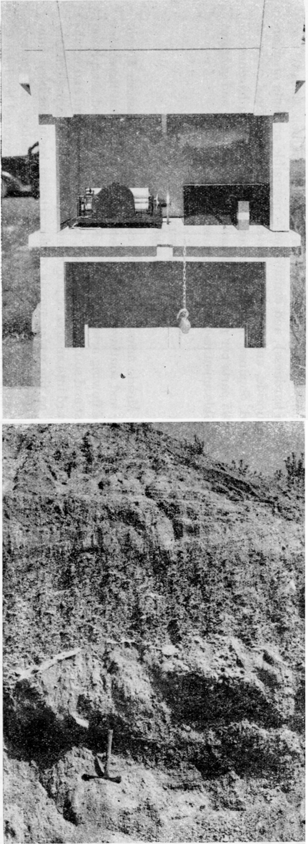
Plate 3—Upper: Automatic recorder on observation well in northern Ford County, for obtaining continuous record of ground-water levels. (Photo by H. A. Waite). Lower: Exposure of coarse gravel in the Ogallala formation in Meade County (SE sec. 17, T. 33 S., R. 28 W.), showing type of stream-borne material that is very permeable. (Photo by S. W. Lohman).
The Meade artesian basin in central and northeastern Meade County and southwesternmost Ford County is the most important area of flowing artesian wells in Kansas. It is limited sharply on the east and southeast by a fault, and grades westward and northwestward into an area of unconfined ground water. A preliminary report on the water supply of the artesian basin has been published (Frye, 1940); a detailed report on the geology and groundwater resources of Meade County has been prepared by John C. Frye and will be published as a bulletin of the State Geological Survey of Kansas. The Meade artesian basin is a fertile agricultural region, and is immediately adjacent to the most extensive deposits of volcanic ash in the state. The important Hugoton gas field is situated to the west of Meade County, and there are several oil fields northeast of the county.
In the Meade basin proper artesian water is obtained from beds of Tertiary and Quaternary sand and gravel (pl. 3) at depths of 100 to 300 feet, but in some localities deeper drilling to depths of 400 or 500 feet has resulted in more abundant supplies. In a few wells water will rise in pipes as much as 18 feet above the surface of the land, although in most wells the rise is less than 10 feet. Water under artesian pressure sufficient to cause it to rise to within less than 20 feet of the surface occurs to the north and northeast of the flowing well district.
In 1940 there were 10 pumped irrigation wells in operation in the artesian basin, all but one of which are situated outside of the flowing well area. These wells are about 200 feet deep, and most of them are 18 inches in diameter. The irrigation well on the Christopher Sobba farm northwest of Fowler yields 850 gallons a minute with a draw-down of about 20 feet (pl. 2).
In 1939 there were more than 200 flowing wells and several large artesian springs in the artesian basin. It is estimated that the total discharge by natural flow is about 6,470 acre-feet annually, o.r about 5,750,000 gallons a day. Considerably less than half of this discharge is used; the rest flows into streams. About 630 acre-feet annually, or an average of about 550,000 gallons a day, is pumped for public supplies and for irrigation. It has been estimated that if the artesian basin were developed by large pumped wells to the extent that all natural flows at the surface would cease, the safe yield of the entire basin would be of the order of magnitude of about 10,000 acre-feet a year, or nearly 9,000,000 gallons a day.
Supplies of 1,000,000 to 3,000,000 gallons a day could be developed from wells in parts of the flowing well area or in the non-flowing well areas adjacent to the basin. Such development within or very close to the flowing well area would cause nearby wells to stop flowing, and withdrawal of larger quantities would affect a proportionately larger number of flowing wells. Thus if water supplies for national defense plants are to be developed from wells in the Meade artesian basin, consideration should be given to possible damage that might result to existing ground-water supplies.
The water from most of the wells in the basin has less than 200 parts per million of hardness (most of which is carbonate hardness), and contains less than 25 parts of chloride. Most of the waters contain less than 0.15 part per million of iron and less than 1 part of fluoride. Water of this quality is satisfactory for most industrial uses.
The Great Bend region occupies a large area in central Kansas west of Hutchinson and east of Kinsley. The central Arkansas river valley (11), the Pawnee river valley (12), and the Kiowa County area (13) are included in this region (fig. 2) but are discussed elsewhere in this paper. The Great Bend region is situated to the south and west of important near-by salt mines, and to the west and south of several oil fields. Gypsum mines are situated to the south in Barber County, and sand and gravel are available at many places in the region. The geology and ground-water resources of Kiowa County, part of which is in the Great Bend region, have been studied by B. F. Latta, but no ground-water studies have been made in other parts of this region. The report on Kiowa County will be published by the State Geological Survey of Kansas.
This region is underlain in most places by deposits of water-bearing sand and gravel of Tertiary and Quaternary age that range in thickness from a few feet to perhaps 300 feet. These deposits are mantled over large areas by sand dunes, which provide excellent facilities for recharge. The depth to water level probably is less than 100 feet in most parts of the area, and locally, in the eastern part, a few wells are reported to flow at the land surface.
Most of the domestic and public water supplies in this region are obtained from drilled wells that end in sand or gravel. A well at Stafford is reported to yield 500 gallons a minute, and it is possible that in some localities yields of as much as 1,000 gallons a minute might be obtainable. Scanty data indicate that supplies of 1,000,000 to 5,000,000 gallons a day probably could be developed at favorable localities from properly constructed wells, and further study of the area may reveal localities in which larger supplies are available. Larger supplies than those stated probably would be available for a period of a few years during the present emergency.
Analyses of water from 10 domestic and public-supply wells in this region indicate that the waters from these wells range in hardness from 85 to 275 parts per million (most of which is carbonate hardness), and contain from 3 to 125 parts of chloride. All of the samples contained less than one part per million of iron, and most of them contained less than 0.1 part. Some of the ground waters near salt marshes in the central part of this region, notably along Rattlesnake creek, may contain considerable chloride. Most of the waters, however, seem to be of satisfactory quality for most industrial uses.
Areas Underlain by Tertiary and Quaternary Deposits
This section of the paper is concerned only with the part of the south-central region that is underlain by Tertiary and Quaternary deposits and that is indicated by diagonal ruling in figure 2. The part of the region south of the Arkansas valley that is shown without diagonal ruling in figure 2 is underlain by Permian rocks, and is discussed in a later section. The eastern Arkansas river valley (10) and some adjacent areas are discussed briefly in a preceding section and in some detail in a recent bulletin of the State Geological Survey (Lohman, 1942). A report on the geology and ground-water resources of Kiowa County, by Bruce F. Latta, and a similar report for Barber County, by Frank Byrne, are now in preparation and will be published later by the State Geological Survey of Kansas. The south-central region is an important agricultural and stock-raising area, and contains several oil and gas fields and deposits of gypsum, volcanic ash, and sand and gravel.
The unconsolidated deposits in the part of the region indicated by diagonal ruling in figure 2 comprise alluvium along the major streams, local basin-filling material, and Tertiary mantle deposits on the uplands. In some places, notably in the upland areas, the deposits are relatively thin, and near the eastern escarpment of the uplands water contained in the deposit escapes through springs and seeps. In southeastern Kiowa County the aggregate discharge from springs of this type is about 16,000,000 gallons a day. In some places south and east of the escarpment the unconsolidated deposits are 30 to 80 feet thick and locally yield as much as 450 gallons a minute to individual wells. Unconsolidated deposits near Harper and in the Englewood and Ashland basins of Clark County are especially productive for this region. It is possible that in favorable areas yields of 750 to possibly 1,000 gallons a minute could be obtained from individual wells of proper construction.
Supplies of 100,000 to 1,000,000 gallons a day are available from wells in favorable localities, and at a few especially favorable places supplies as large as 5,000,000 gallons a day probably could be obtained. Larger supplies would be available for a period of a few years during the present emergency.
Analyses of water from municipal wells of-about 20 cities in this part of the south-central region indicate that most of the waters range in hardness from 70 to 250 parts per million (mostly carbonate hardness) , but that a few waters range in hardness from 300 to 450 parts. Most of the waters contain very little iron and less than 100 parts per million of chloride, but a few waters contain from 100 to 300 parts of chloride. The underlying and adjacent Permian rocks generally yield meager quantities of water that is excessively hard, and are to be avoided as sources of industrial water supply.
The northwestern region comprises the six counties in the northwestern part of the state north of Smoky Hill river and also parts of adjacent counties. The region is in the High Plains section and is underlain by Tertiary and Quaternary deposits that rest upon Cretaceous bedrock. The surface is mantled by loess in most places. Information on the geology and ground-water supplies of part of the region is contained in reports of the State Geological Survey (Elias, 1931, 1937; Landes and Keroher, 1939).
The Tertiary and Quaternary deposits are several hundred feet thick in many parts of this region, and contain beds of permeable sand and gravel that supply water to most of the wells. Permeable alluvium that occupies some of the larger valleys also supplies water to many wells. The depth to water level in the uplands ranges from 50 to more than 150 feet. In most places individual wells in these deposits yield 50 to 200 gallons a minute, and locally individual wells yield as much as 1,000 gallons a minute. Because of the discontinuous nature of most of the beds of sand and gravel, preliminary test drilling should precede the selection of final well sites. Supplies of 1,000,000 gallons a day or more could be obtained from wells in many parts of this region, and supplies of as much as 5,000,000 gallons a day are obtainable in favorable areas. Larger supplies would be available for a period of a few years during the present emergency.
Analyses of water from 11 municipal wells in this region indicate that most of the waters from these wells range in hardness from 170 to 300 parts per million, but that some waters have 300 to 420 parts. Most of the waters contain very little iron and less than 25 parts per million of chloride. In general, the ground water in this region seems to be of satisfactory quality for most industrial uses.
The southwestern region embraces a large part of southwestern Kansas (fig. 2). It is in the High Plains section and comprises a relatively flat upland plain drained by Smoky Hill, Arkansas, and Cimarron rivers. The Meade artesian basin (14), Scott-Finney shallow water basin (15), western Arkansas river valley (16), and the Grant-Stanton shallow water basin (17) included in this region are discussed elsewhere; this chapter is concerned only with the" availability of ground water in the adjacent uplands and smaller stream valleys. Information on the geology and ground-water resources of parts of this area is given in reports published by the State Geological Survey (Elias, 1931; Lohman, 1938; Frye, 1940; Latta, 1941; and McLaughlin, 1942). Reports on other areas in this region are in press or in preparation (fig. 1).
Most of the wells in this region obtain water from Tertiary and Quaternary deposits. The deposits range in thickness from a few feet to more than 600 feet and consist principally of silt and sand with smaller amounts of gravel. The greatest thicknesses of these deposits were encountered in gas-test wells in the southern parts of Morton and Stevens counties. Wells that obtain water from these deposits range in depth from about 50 to nearly 400 feet. The depth to water level in these wells ranges from about 40 to more than 250 feet below the land surface.
Moderately large quantities of water can be obtained from wells in the uplands of this region. The yields of wells in the uplands. range between 50 and about 1,000 gallons a minute. The depths to water level in these wells range from about 100 to more than 250 feet. Several upland wells are described in the following paragraphs.
The Schwendt well, situated near Leoti in Wichita County, is a 16-inch, gravel-walled well and has a static water level of 90 feet. The well has a measured yield of 950 gallons a minute with a drawdown of 35 feet.
The irrigation well of Alfred Ward is in the SW sec. 23, T. 27 S., R. 42 W; in Stanton County. It is a 16-inch, gravel-walled well drilled to a depth of 247 feet. The depth to water level is 157 feet below the land surface. The well yields 430 gallons a minute with a draw-down of 68 feet.
The irrigation well of Arthur Slocum in the NW sec. 25, T. 27 S., R. 27 W., in Gray County, is 200 feet deep. The depth to water level is about 165 feet below the land surface. It is a 16-inch, gravel-walled well equipped with a turbine pump and yields 800 gallons a minute with a draw-down of 20 feet after 11 hours of pumping.
Public supply well no. 6 at Elkhart, Morton County, is 260 feet deep and has a static water level about 200 feet below the land surface. It is equipped With a turbine pump and yields 80 gallons a minute with a draw-down of 30 feet after several hours of pumping.
In parts of Hamilton, Stanton, Morton and Ford counties, wells obtain water from Cretaceous sandstones. The Cretaceous rocks range in thickness from a few feet to more than 1,000 feet. Wells that penetrate Cretaceous deposits range in depth from about 25 feet to 850 feet. The depth to water level in these wells ranges from 15 feet to 375 feet. In general, wells that penetrate Cretaceous sandstone in this region yield much less water than those in the Tertiary and Quaternary deposits. A well in northwestern Morton County yields about 300 gallons of water a minute from Cretaceous rocks. Another well in northern Hamilton County was drilled to a depth of 850 feet and encountered water in Cretaceous sandstones at a depth of 800 feet; the water rose under artesian pressure to a level 375 feet below the land surface. The well is equipped with a plunger-type pump and yields less than 15 gallons a minute with a draw-down of more than 375 feet.
Most of the wells in upland areas of the southwestern region are domestic and stock wells that withdraw only small amounts of water each year. Because the water resources of this area are relatively undeveloped, it seems that moderately large supplies of water could be developed for national defense plants. Supplies of 1,000,000 to 5,000,000 gallons or more a day probably could be developed at favorable localities underlain by Tertiary and Quaternary deposits. Larger supplies would be available for a period of a few years during the present emergency.
Water from Tertiary and Quaternary deposits in the upland areas ranges in hardness from about 150 to 450 parts per million and contains 150 to 650 parts per million of dissolved solids. Most waters contain less than 0.15 part per million of iron, but a few contain as much as 13 parts. The content of fluoride ranges from 0.2 part to about 2.5 parts per million.
Water from Cretaceous sandstones is in general of poorer quality, and may contain between 325 and 850 parts per million of dissolved solids and have a hardness of 100 to 350 parts. Most of the waters contain less than 0.15 part per million of iron, but a few contain as much as 10 parts. Some waters contain as much as 3.5 parts per million of fluoride.
Most waters from the Cretaceous, Tertiary, and Quaternary deposits contain less than 50 parts per million of chloride, but a few in local areas contain more than 100 parts.
In this section are discussed the relatively unproductive parts of the state underlain mainly by rocks of Pennsylvanian, Permian, or Cretaceous age. The productive stream valleys that traverse some of these areas are discussed earlier in this report, and some of lesser importance are noted below.
The northeastern region includes the part of the state lying north of Kansas river and east of the eastern limit of Cretaceous rocks. The northeastern region was overriden by continental glaciers during the great ice age and in this respect differs from all other parts of Kansas. A general discussion of the occurrence of ground water in this region is contained in a report by Moore (1940, p. 54), and conditions in Atchison County have been described by Frye (1941). The availability of large supplies of ground water in. the large stream valleys that adjoin and traverse this region is discussed earlier in this report.
In the northeastern region ground water is obtained from Pennsylvanian and Permian sandstones and limestones, from shallow .alluvium along the stream valleys, and from glacial till and outwash that covers much of the uplands and valley slopes. The depth to water level in this region is less than 50 feet in most places and in many places is less than 10 feet. Wells obtaining water from bedrock are drilled to depths as great as 200 or 300 feet, but wells in alluvium or glacial deposits generally do not exceed 50 to 75 feet in depth.
In general, only very small supplies of water are obtained from the bedrock formations that underlie this region. In many places sufficient water for domestic or stock use is obtained from wells ending in sandstone or limestone, but such supplies are inadequate for industrial use. Wells ending in alluvium or glacial outwash may yield from as little as 10 gallons a minute to a maximum of about 100 gallons a minute. Except in the major stream valleys, as described elsewhere, it is unlikely that supplies of more than 100,000 gallons a day could be developed from wells anywhere in this region.
Analyses of waters from 11 municipal wells in this region indicate that the waters range in hardness from 250 to more than 500 parts per million (nearly all carbonate hardness, and contain 2 to less than 75 parts of chloride. Most of the waters contain less than 0.1 part per million of iron but a few contain more than 1 part.
The southeastern region includes in general the area south of Kansas river and east of the sixth principal meridian. It includes the southeastern deep water area (9), described elsewhere in this report. A general description of the ground-water resources of this large region is given in a report by Moore (1940, pp. 50-54). Studies made along the Neosho river valley near Parsons by C. C. Williams will be described in a forthcoming bulletin of the State Geological Survey.
Most of the ground water in this area is obtained from limestones of Pennsylvanian or Permian age and from shallow alluvium along stream valleys. In a narrow belt that trends a little east of north to west of south and passes through Woodson County, many wells obtain water from Pennsylvanian sandstone. Most of the wells in the southeastern region are relatively shallow, although many of the wells that tap limestone or sandstone are several hundred feet deep.
The southeastern region, as a whole, is lacking in ground-water reservoirs capable of yielding large supplies of water. In the past there have been dry years when it was difficult or even impossible, in many parts of this region, to obtain sufficient ground water for stock use.
During years of fairly abundant rainfall and stream flow, supplies of 100,000 to 400,000 gallons a day could be obtained from wells in alluvium of the Neosho river valley in the southern part of the region; comparable if not somewhat large supplies probably could be obtained from the alluvium of the Marais des Cygnes (Osage) river valley near the Missouri state line. Supplies of as much as 100,000 gallons a day probably could be obtained from wells along the sandstone belt, and perhaps at a few other places, but in most other parts of the region the available supply is much smaller. Doubtless somewhat larger supplies than those indicated above would be available for a period of a few years during the present emergency.
The ground waters of this region range greatly in quality. Water from the alluvium a~d some of the bedrock formations generally is satisfactory for domestic and stock use, but waters from the Permian rocks in the western part of the the region and locally from limestones in different parts of the region may be highly mineralized, excessively hard, and unsatisfactory for most purposes. Analyses of water from 26 municipal wells in this region indicate that most of the waters range in hardness from 200 to 600 parts per million, but a few waters have 750 to more than 2,000 parts of hardness. In some waters the hardness is chiefly carbonate hardness, but in others, particularly in the western part of the region, it is mainly non-carbonate hardness. Most of these waters contain less than 50 parts per million of chloride, but a few contain more than 100 parts and a few, particularly from deep sources, may contain more than 1,000 parts of chloride. Most of the waters contain less than 0.15 part per million of iron, but some contain from 1 to 10 parts or more.
The north-central region comprises a large area in central and north-central Kansas and a smaller area in west-central Kansas (fig. 2). It includes practically the entire outcrop area of Cretaceous rocks north of Arkansas river. A general discussion of the occurrence of ground water in this region is contained in a report by Moore (1940, pp. 54-56). Additional information on water supplies is contained in other bulletins of the State Geological Survey (Rubey and Bass, 1925; Bass, 1926; Wing, 1930; Landes, 1930; Elias, 1931; and Moss, 1932). The following discussion of available ground-water supplies is applicable mainly to the interstream areas; conditions in the four large valleys that traverse the eastern part of the region are discussed separately elsewhere in this report.
Most of the Cretaceous rocks that underlie this region are composed of relatively impermeable shale or chalk that yield little or no water to wells. Cretaceous sandstone, which crops out over a large area in the eastern part of the region and locally in the central part, yields somewhat larger supplies to wells. Thin patches of Tertiary and Quaternary deposits cap some of the uplands but are relatively unimportant as sources of ground water. Small supplies of water are available from alluvium and terrace deposits along some stream valleys in the region. Water wells in this region range in depth from less than 20 feet to as much as 800 feet, and the depth to water level ranges within wide limits. Aside from the larger valleys (described elsewhere), there seem to be no areas in the north-central region wherein could be developed groundwater supplies adequate for use by national defense plants.
In most parts of the north-central region ground water is hard but of satisfactory quality for many purposes. The water in the Cretaceous sandstones generally is of good quality in the areas of outcrop, but where deeply buried the sandstone generally contains salty water. Analyses of water from 18 municipal wells in the region indicate that the waters from these wells range in hardness from 200 to more than 600 parts per million (chiefly carbonate hardness). Water from most of these wells contains less than 50 parts per million of chloride, but a few contain more than 100 parts. Most of the waters contain very little iron but a few contain from 1 to more than 10 parts per million of iron.
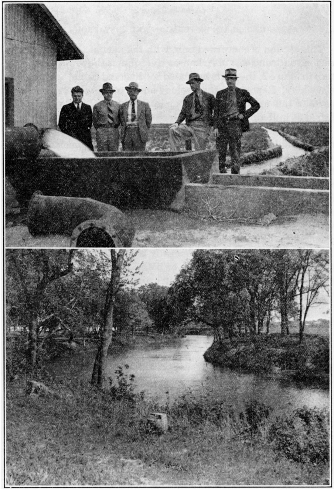
Plate 4—Upper: View of discharge from irrigation well in the Scott County shallow water basin (NW NE sec. 28, T. 19 S., R. 33 W.). Well is discharging about 1,850 gallons a minute, but when tested yielded 2,900 gallons a minute with a draw-down of 30.7 feet. (Photo by S. W. Lohman). Lower: Fall river at a point near Neodesha, Wilson County. (Photo by George S. Knapp).
Areas Underlain by Permian and Cretaceous Rocks
This section is concerned only with the part of the south-central region south and east of Arkansas river that is shown without a pattern in figure 2; the parts indicated by diagonal ruling are discussed elsewhere. Reports on the geology and ground-water resources of parts of this area are in press or in preparation and will be published as bulletins of the State Geological Survey (fig. 1).
Most of the area under consideration is underlain by relatively impermeable beds of Permian shale, siltstone, limestone, sandstone, and gypsum, but small areas in the western part are underlain by Cretaceous shale and sandstone. In most places wells in these rocks yield from one to five gallons a minute or more, sufficient for domestic or stock use; but supplies large enough for industrial use are not obtainable from these rocks. Somewhat larger supplies are available from alluvium along the principal streams, particularly along Cimarron and Medicine Lodge rivers.
The water from bedrock generally is of poor quality and locally may be excessively hard, salty, or both. The water from the alluvium generally is of somewhat better quality.
The flow of streams is not constant but ranges within wide limits, not only from year to year but from month to month and from day to day. The United States Department of Interior, Geological Survey, in cooperation with the Division of Water Resources of the Kansas State Board of Agriculture and the U.S. Army Engineers, maintains many gaging stations on the principal streams of the state. The locations of these gaging stations are shown in figure 3. A summary of the discharge of Kansas streams is given in table 1, and the gaging stations are listed in table 2.
Figure 3—Map of Kansas showing gaging stations maintained on streams, as of February 1, 1942. Cooperating agencies: U.S. Department of Interior, Geological Survey; U.S. Army Engineers; and Division of Water Resources, Kansas State Board of Agriculture.
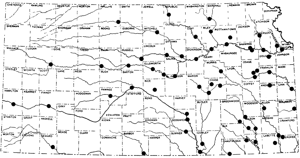
Detailed stream-flow records of Kansas streams are available in the state reports mentioned below and in Water-Supply Papers of the U.S. Geological Survey. Stream-flow records for 1895-1919 and for 1919-1924 are contained in reports on the Surface Waters of Kansas issued in 1920 and 1925, respectively, by the Kansas Water Commission. Records for 1924-1928, 1928-1935, and 1935-1939 are contained in the 1928, 1937, and 1940 reports of the Kansas State Board of Agriculture, Division of Water Resources. Information on the flow of Kansas streams may be obtained also by writing to the Division of Water Resources, Kansas State Board of Agriculture, Topeka, or to the U.S. Geological Survey, Topeka.
Table 1—Summary of discharge of Kansas streams.
| River and Location | Length of Record (years) |
Area of Drainage Basin (sq. miles) |
Minimum Daily Discharge (millions of gallons a day1) |
Date | Mean Daily Discharge (millions of gallons a day) |
|---|---|---|---|---|---|
| Missouri, at Kansas City, Mo. 2 | 13 | 489,200 | 3 970 | Jan. 10, 1937 | 23,250 |
| Kansas, at Bonner Springs | 23 | 58,890 | 197 | Sept., 1934 | 3,020 |
| Marais des Cygnes, at | 24 | 1,260 | 0 | Several periods | 310 |
| Neosho, at Parsons | 20 | 4,828 | 0 | Several periods | 1,260 |
| Verdigris, at Independence | 20 | 2,952 | 0 | Several periods | 891 |
| Arkansas, at Arkansas City | 20 | 44,700 | 29.1 | Aug. 19, 1933 | 752 |
| Little Arkansas, at Valley Center | 19 | 1,316 | .65 | Dec. 27, 1933 | 92 |
| Walnut, at Winfield | 19 | 1,894 | 0 | Several periods | 356 |
| Delaware, at Valley Falls | 18 | 922 | .06 | In 1934 | 187 |
| Big Blue, at Randolph | 22 | 9,100 | 27.1 | Aug. 9, 10, 13, 1934 | 720 |
| Republican, at Clay Center | 4 23 | 24,500 | 0 | In Aug. & Sept., 1934 | 566 |
| Solomon, at Niles | 27 | 6,770 | .65 | Sept. 4, 1926 | 285 |
| Saline, at Tescott | 21 | 2,820 | 0 | Several periods in 1935 | 99 |
| Smoky Hill, at Ellsworth | 27 | 7,580 | 1.0 | Oct. 9, 10, 1922 | 130 |
| 1million gallons per day equals 1.547 cubic feet per second; 1 cubic foot per second equals .646317 million gallons per day. 2 Data supplied by H; C. Beckman, U.S. Geological Survey, Rolla, Missouri. 3 Occurred during ice jam between St. Joseph and Kansas City. 4 Wakefield, 1918-33; Clay Center, 1934-40. |
|||||
Table 2—Gaging stations maintained on Kansas streams. [Cities named represent locations at or near which gaging stations were maintained during the periods indicated. Stations with dates followed by a dash were active on February 1, 1942.]
| Missouri River Basin | ||
| Kansas River Basin | ||
| Republican river at Scandia, 1919-1925; 1928- | ||
| Republican river at Clay Center, 1934- | ||
| Republican river at Wakefield, 1917-1934 | ||
| Republican river at Junction City, 1895-1905 | ||
| West Buffalo creek near Jewell, 1934-1938 | ||
| West Buffalo creek at Jewell, 1934-1938 | ||
| Kansas river at Ogden, 1917- | ||
| Kansas river at St. George, 1904 | ||
| Kansas river at Wamego, 1914- | ||
| Kansas river at Topeka, 1904; 1917- | ||
| Kansas river at Lecompton, 1896; 1899-1906; 1936- | ||
| Kansas river at Lawrence, 1881-1899 | ||
| Kansas river at Bonner Springs, 1917- | ||
| Smoky Hill river at Elkader, 1940- | ||
| Smoky Hill river at Jerome, 1928-1932 | ||
| Smoky Hill river near Ellis, 1942- | ||
| Smoky Hill river at Pfeifer, 1929-1932 | ||
| Smoky Hill river near Russell, 1940- | ||
| Smoky Hill river at Ellsworth, 1895-1905; 1918-1925; 1928- | ||
| Smoky Hill river near Langley, 1941- | ||
| Smoky Hill river at Lindsborg, 1905-1923; 1930- | ||
| Smoky Hill river near Mentor, 1923-1932 | ||
| Smoky Hill river at Solomon, 1904; 1922-1934 | ||
| Smoky Hill river near Abilene, 1904-1921 | ||
| Smoky Hill river at Enterprise, 1934- | ||
| Ladder creek near Scott City, 1904-1905 | ||
| Saline river at Beverly, 1895-1897 | ||
| Saline river near Wilson, 1929- | ||
| Saline river at Tescott, 1919- | ||
| Saline river near Salina, 1897-1903 | ||
| North Fork of Solomon river at Kirwin, 1919-1925; 1928-1932; 1942- | ||
| South Fork of Solomon river at Alton, 1919-1925; 1928-1932 | ||
| Solomon river at Beloit, 1895-1897 ;1905; 1929- | ||
| Solomon river near Bennington, 1917-1919 | ||
| Solomon river at Niles, 1897-1903; 1919- | ||
| East Limestone creek near Ionia, 1934-1938 | ||
| East Limestone creek at Ionia, 1934-1935 | ||
| Elm creek near Ionia, 1934-1938 | ||
| Big Blue river at Hull, 1919-1925; 1928-1940 | ||
| Big Blue river at Randolph, 1918- | ||
| Big Blue river near Manhattan, 1895-1905 | ||
| Little Blue river at Waterville, 1922-1925; 1928- | ||
| Vermillion creek near Wamego, 1936- | ||
| Soldier creek near Topeka, 1929- | ||
| Delaware river at Valley Falls, 1922- | ||
| Wakarusa river near Lawrence, 1929- | ||
| Stranger creek near Tonganoxie, 1929- | ||
| Beaver Creek Basin | ||
| Beaver creek at Ludell, 1929-1932 | ||
| Sappa Creek Basin | ||
| Sappa creek near Oberlin, 1929-1932 | ||
| Prairie Dog Creek Basin | ||
| Prairie Dog creek near Woodruff, 1929-1932 | ||
| Marais des Cygnes River Basin | ||
| Marais des Cygnes river at Melvern, 1939- | ||
| Marais des Cygnes river near Quenemo, 1922-1938 | ||
| Marais des Cygnes river at Ottawa, 1902-1905; 1911-1914 | ||
| Marais des Cygnes river near Ottawa, 1918- | ||
| Marais des Cygnes river at Trading Post, 1921-1923; 1928- | ||
| Salt creek near Lyndon, 1940- | ||
| Dragoon creek near Quenemo, 1940- | ||
| Pottawatomie creek near Garnett, 1940- | ||
| Pottawatomie creek at Lane, 1929-1932 | ||
| Big Bull creek at Paola, 1929-1932 | ||
| Big Sugar creek at Farlinville, 1929-1932 | ||
| Marmaton river near Fort Scott, 1921-1925; 1929- | ||
| Lower Mississippi River Basin | ||
| Arkansas River Basin | ||
| Arkansas river near Coolidge, 1903; 1921 | ||
| Arkansas river at Syracuse, 1902-1906; 1921- | ||
| Arkansas river at Garden City, 1922- | ||
| Arkansas river at Dodge City, 1903-1906 | ||
| Arkansas river at Larned, 1922-1940 | ||
| Arkansas river at Great Bend, 1909-1913; 1941- | ||
| Arkansas river at Hutchinson, 1895-1905 | ||
| Arkansas river near Wichita, 1921-1935 | ||
| Arkansas river at Wichita, 1897-1919; 1934- | ||
| Arkansas river at Arkansas City, 1902-1906; 1921- | ||
| Amazon canal near Hartland, 1921- | ||
| South Side ditch near Hartland, 1921- | ||
| Great Eastern canal at Lakin, 1921- | ||
| Farmers' ditch near Garden City, 1921- | ||
| Garden City canal near Garden City, 1921- | ||
| Pawnee river near Larned, 1924- | ||
| Cow creek near Lyons, 1938- | ||
| Little Arkansas river at Valley Center, 1922- | ||
| Ninnescah river near Peck, 1938- | ||
| Ninnescah river at Belle Plaine, 1928-1930 | ||
| Walnut river at Winfield, 1921- | ||
| Walnut river at Arkansas City, 1902-1903 | ||
| Diversion canal from Arkansas river at Arkansas City, 1921-1923 | ||
| Cimarron River Basin | ||
| Cimarron river near Liberal (at Arkalon), 1895-1896; 1903-1905; 1938- | ||
| Medicine Lodge River Basin | ||
| Medicine Lodge river near Kiowa, 1895-1896; 1939- | ||
| Verdigris River Basin | ||
| Verdigris river near Coyville, 1939- | ||
| Verdigris river near Altoona, 1939- | ||
| Verdigris river at Independence, 1904; 1921- | ||
| Verdigris river near Liberty, 1895-1903 | ||
| Fall river near Fall River, 1939- | ||
| Fall river at Fall River, 1904-1905 | ||
| Fall river at Fredonia, 1939- | ||
| Elk river near Elk City, 1939- | ||
| Caney river near Elgin, 1939- | ||
| Neosho River Basin | ||
| Neosho river at Council Grove, 1939- | ||
| Neosho river at Neosho Rapids, 1904 | ||
| Neosho river at Iola, 1895-1903 | ||
| Neosho river near Iola, 1917- | ||
| Neosho river near Parsons, 1921- | ||
| Cottonwood river near Marion, 1939- | ||
| Cottonwood river a Elmdale, 1922-1932 | ||
| Cottonwood river at Cottonwood Falls, 1932- | ||
| Cedar creek near Cedar Points, 1939- | ||
| Middle creek near Elmdale, 1939- | ||
| Lightning creek near McCune, 1939- | ||
| Labette creek near Oswego, 1939- | ||
Abernathy, G. E., 1941, Ground-water resources of Mississippian and older rocks in Bourbon, Crawford, Cherokee, and Labette counties, southeastern Kansas: Kansas Geol. Survey, Bull. 38, part 8, pp. 221-236, fig. 1. [available online]
Bass, N. W., 1926, The geology of Ellis County, Kansas: Kansas Geol. Survey, Bull. 11, part 1, pp. 1-52, figs. 1-12, pls. 1-4. [available online]
Bass, N. W., 1926a, The geology of Hamilton County, Kansas: Kansas Geol. Survey, Bull. 11, part 2, pp. 53-83, figs. 13-26, pls. 5-6. [available online]
Elias, M. K., 1931, The geology of Wallace County, Kansas: Kansas Geol. Survey, Bull. 18, pp. 1-252, figs. 1-7, pls. 1-42. [available online]
Elias, M. K., 1937, Geology of Rawlins and Decatur counties (Kansas) with special reference to water resources: Kansas Geol. Survey, Mineral Resources Circ. 7, pp. 1-25, figs. 1-4. [available online]
Frye, John C., 1940, A preliminary report on the water supply of the Meade artesian basin, Meade County, Kansas: Kansas Geol. Survey, Bull. 35, pp. 1-39, figs. 1-7, pls. 1-5. [available online]
Frye, John C., 1941, Reconnaissance of ground-water resources in Atchison County, Kansas: Kansas Geol. Survey, Bull. 38, part 9, pp. 237-260, figs. 1-6, pls. 1-3; [available online]
Jewett, John M., 1941, The geology of Riley and Geary counties, Kansas: Kansas Geol. Survey Bull. 39, pp. 1-164, figs. 1, 2, pls. 1-17. [available online]
Landes, Kenneth K., and Ockerman, J. W., 1930, The geology of Mitchell and Osborne counties, Kansas: Kansas Geol. Survey, Bull. 16, pp.1-54, fig. 1, pls. 1-15. [available online]
Landes, Kenneth K., and Keroher, Raymond P., 1939, Geology and oil and gas resources of Logan, Gove, and Trego counties, Kansas: Kansas Geol. Survey, Mineral Resources Circ. 11, pp. 1-45, figs. 1-8, pls. 1-4. [available online]
Latta, Bruce F., 1941, Geology and ground-water resources of Stanton County, Kansas: Kansas Geol. Survey, Bull. 37, pp. 1-119, figs. 1-6, pls. 1-9. [available online]
Lohman, Stanley W., 1938, Water supplies from wells available for irrigation in the uplands of Ford County, Kansas: Kansas Geol. Survey, Mineral Resources Circ. 9, pp. 1-10, index map. [available online]
Lohman, Stanley W., 1941, Ground-water conditions in the vicinity of Lawrence, Kansas: Kansas Geol. Survey, Bull. 38, part 2, pp. 17-64, figs. 1-6, pls. 1, 2. [available online]
Lohman, Stanley W., 1942, Ground-water supplies available for national defense industries in south-central Kansas: Kansas Geol. Survey, Bull. 41, part 1, pp. 1-20, figs. 1-5. [available online]
Lohman, Stanley W., and Frye, John C., 1940, Geology and ground-water resources of the "Equus beds" area in south-central Kansas: Economic Geology, vol. 35, no. 7, pp. 839-886, figs. 1-5.
McLaughlin, Thad G., 1942, Geology and ground-water resources of Morton County, Kansas: Kansas Geol. Survey, Bull. 40, pp. 1-126, figs. 1-6, pls, 1-9: [available online]
Moore, R. C., 1940, Ground-water resources of Kansas: Kansas Geol. Survey, Bull. 27, pp. 1-112, figs. 1-28, pls. 1-34. [available online]
Moss, R. G., 1932, The geology of Ness and Hodgeman counties: Kansas Geol. Survey, Bull. 19, pp. 1-48, fig. 1, pls. 1-7. [available online]
Rubey, W. W., and Bass, N. W., 1925, The geology of Russell County, Kansas, with special reference to oil and gas resources: Kansas Geol. Survey, Bull. 10, pp. 1-104. [available online]
Smith, H. T. U., 1940, Geologic studies in southwestern Kansas: Kansas Geol. Survey, Bull. 34, pp. 1-212, figs. 1-22, pls. 1-34. [available online]
Waite, H. A., 1941, Factors producing a nine-year decline in ground-water levels in Scott County, Kansas: Am. Geophysical Union, Trans. 1941, pp. 772-775, figs. 1, 2.
Wing, Monta E., 1930, The geology of Cloud and Republic counties, Kansas: Kansas Geol. Survey, Bull. 15, pp. 1-51, figs. 1, 2, pls. 1-18. [available online]
Kansas Geological Survey
Placed on web Nov. 17, 2017; originally published April 24, 1942.
Comments to webadmin@kgs.ku.edu
The URL for this page is http://www.kgs.ku.edu/Publications/Bulletins/41_2/index.html