Kansas Geological Survey, Bulletin 38, pt. 8, originally published in 1941
Originally published in 1941 as part of Kansas Geological Survey Bulletin 38, pt. 8. This is, in general, the original text as published. The information has not been updated. An Acrobat PDF version (3 MB) is also available.
Large quantities of ground water suitable for domestic and industrial uses may be obtained from drilled wells in an area of about 2,000 square miles located in Bourbon, Crawford, Cherokee, and Labette counties, Kansas. These counties adjoin the eastern and southern state boundaries and they comprise part of the mining district in southwestern Missouri, southeastern Kansas, and northeastern Oklahoma that is known as the Tri-State area. The water wells of this region that penetrate Mississippian or older rocks are artesian wells in which the water is under sufficient hydrostatic pressure to flow or rise several hundred feet above the point in the well at which the water is encountered. The beds of rock that are the chief reservoirs for ground water lie at a minimum depth of 300 feet and a maximum depth of 1,700 feet beneath the surface in southeastern Kansas, and crop out at the surface in south-central Missouri, along the axis of the Ozark Uplift, where water enters these beds from local rainfall. The chief ground-water zones in the Tri-State district are, in ascending order, Lamotte sandstone (Upper Cambrian), Roubidoux sandstone (Lower Ordovician), Jefferson City-Cotter dolomites (Lower Ordovician), and Boone limestone (Mississippian, Lower Carboniferous). Most of the water for domestic use is pumped from the Roubidoux sandstone. Some of the cities in the district consume about 2,000,000 gallons of water per day. A pumping test in Cherokee county, Kansas, indicated that 8,000,000 gallons of water a day was pumped from the Reeds Spring formation (Mississippian). The dissolved mineral content of the ground water in this district increases down the dip of the rock formations, that is, the solid matter (in parts per million) increases with the distance the ground water migrates through the rock.
The area that is treated in this report consists primarily of Bourbon, Crawford, Cherokee, and Labette counties in southeastern Kansas. Incidental attention is given to the western part of Vernon and Jasper counties in southwestern Missouri, and the northern part of Ottawa and Craig counties in northeastern Oklahoma.
The area occupies the southwestern flank of the Ozark dome, which is broadly elliptical in form, its major axis trending northeast. The surface consists of moderately dissected Paleozoic strata that dip gently away from the axis of the Ozark uplift. Most of the area is drained by southward-flowing streams.
This paper was prepared in response to a request from K. A. Spencer, Vice-President and General Manager of the Pittsburg and Midway Coal Company, and Coordinator of National Defense Contract Service, 10th Federal Reserve District; C. Y. Thomas, Chief Engineer of the Pittsburg and Midway Coal Company, and Chairman of the Industrial Committee of the Kansas State Chamber of Commerce; and George Weeks, Secretary of the Industrial Committee of the Kansas State Chamber of Commerce, who asked for a geological report on the ground-water resources of the Tri-State area, to present to the United States War Department in connection with a plan for a series of integrated defense plants that would require 5,000,000 to 10,000,000 gallons of water daily from ground-water sources. This report was delivered to Mr. Spencer on March 4, 1941.
In the course of this preliminary survey of the ground-water resources of the Tri-State area, the subsurface geology of southeastern Kansas and adjoining areas in southwestern Missouri and northeastern Oklahoma was studied from the well logs and records of more than 150 deep wells. These well records give information on the distribution and character of the water-bearing formations. Many of the records include detailed correlations of the beds by means of microscopic examination of the insoluble residues of rock samples from the wells. These correlations have been made over a period of several years by the Kansas Geological Survey at Lawrence, and the Missouri Geological Survey at Rolla, Mo. A detailed map of the water table has been prepared and it shows that the direction of movement of ground water in the Tri-State region is southwestward.
It has been known for many years that there is an abundant supply of ground water in southeastern Kansas, northeastern Oklahoma, and southwestern Missouri. Deep wells have provided the water supply for several towns for more than 40 years. Among these are some large cities of the region-Pittsburgh, Kans., and Carthage, Mo. Deep wells have been the only source of water supply for the zinc- and lead-mining industry of the Tri-State area. The mills use a very large quantity of water in the process of ore concentration. Deep wells have also played an important part in the development -of the coal industry of southeastern Kansas. In the early days, all the hoisting was performed by steam power, and each mine obtained its water supply from deep wells. At the present time, coal-washing and treatment plants in the district depend upon deep wells for their water supply. Several hundred wells have been drilled for water, and in each well a supply of fresh water was obtained suitable for domestic purposes.
I express my appreciation for the generous cooperation given by executives of coal-mining companies of Kansas and Missouri, and of metal-mining companies of Kansas, Missouri, and Oklahoma; and executives of municipal water-supply plants of the district. Special acknowledgment should be made to C. Hoen, Superintendent of the municipal water plant at Carthage, Mo., to C. Rankin, City Water Commissioner of Pittsburg, Kans., and to H. G. Freehauf, Superintendent of the City Water Department of Miami, Okla., for supplying data on quantities of water pumped, analyses of water, and logs of wells. R. K. Stroup and N. E. Ritter of the Eagle Picher Mining and Smelting Company supplied valuable information concerning large-scale pumping tests conducted in Cherokee county, Kansas, well logs of deep water wells in the Tri-State district, and maps of the metal-mining operations of the district. The Pittsburg and Midway Coal Company and George Weeks, Secretary-Manager of the Pittsburg Chamber of Commerce, assisted in gathering field information. S. W. Lohman, Federal geologist in charge of ground water investigations in Kansas assisted with suggestions and advice in preparing the report and read the final manuscript.
The quantity of water that can be obtained from ground-water reservoirs of southeastern Kansas depends primarily upon the area, thickness, porosity, and saturation of the reservoirs, and upon the permeability-the rate that water will pass through the pore spaces or openings in the rock.
The flow of ground water through permeable material varies directly with the hydraulic gradient. Movement of ground water is caused by difference in head between the intake area and the point of discharge. The rate of movement of ground water ranges between wide limits-from as much as 420 feet per day to as little as 1 foot in ten years.
The water wells in southeastern Kansas are artesian wells in which the water is under sufficient hydrostatic pressure to flow from the well or rise in the well to a height above the local water table. Although a few of the wells have been known to flow, in most of the wells the water does not flow, but rises several hundred feet above the point at which it is first encountered, and in some wells, it rises to a point within 50 feet of the surface. The difference in altitude between the intake area in Missouri and the land surface in the discharge area in Kansas is about 600 feet. The depth of the water-bearing beds below the surface ranges from 400 to 1700 feet.
When water is pumped from a well, there is always some drawdown of the water table (under water-table conditions) or of the pressure head (under artesian conditions). Other things being equal, the draw-down varies inversely with the permeability of the water-bearing materials, that is, the greater the permeability the smaller the draw-down. Data on pumping in this area indicate that the cone of depression is very broad, and that the water is being drawn laterally from great distances.
The openings in the ground-water reservoirs in the Tri-State area are of two types. One type comprises small cavities or pore spaces in the rock; the other type comprises cracks, fissures, and solution channels.
The beds of rock that are the chief reservoirs for ground water, and that lie several hundred feet beneath the surface in southeastern Kansas, crop out at the surface in south-central Missouri, along the axis of the Ozark Uplift, where water enters these beds from local rainfall.
Figure 1--Generalized section of rocks in the Tri-State district, southeastern Kansas.
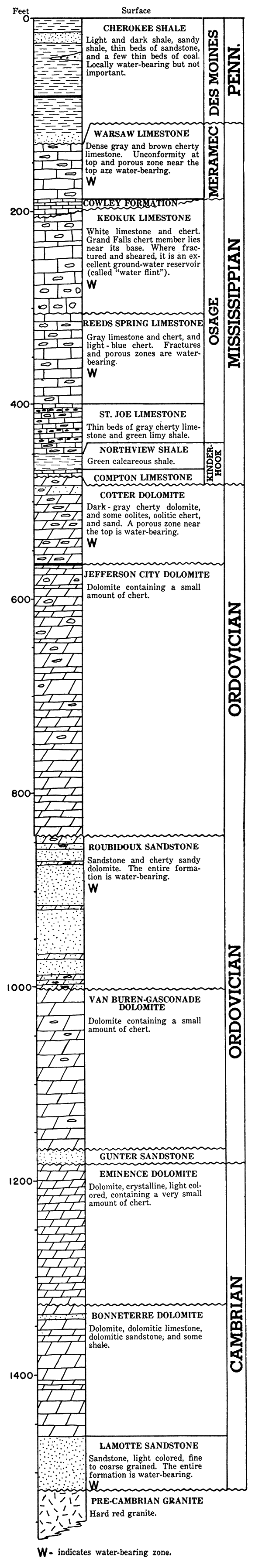
The chief water-bearing formations of the Tri-State district are, in ascending order, the Lamotte sandstone (Upper Cambrian), Roubidoux sandstone (Lower Ordovician), Jefferson City-Cotter dolomites (Lower Ordovician), and Boone (Mississippian, Lower Carboniferous) limestone.
The Lamotte sandstone of the Cambrian system is the deepest water-bearing formation in the Tri-State district. The sandstone ranges in thickness between wide limits in Missouri, according to Dake, (1918), being entirely absent in places where it is cut out at the uneven unconformable contact with underlying pre-Cambrian rocks, and reaching a maximum thickness of about 450 feet in some localities. Its most extensive outcrop area is in the southeastern part of the Ozark region, including Ste. Genevieve, St. Francois, Madison, Washington, and Iron counties, Missouri. In southeastern Kansas, four or five wells have been drilled through the entire thickness of the Lamotte sandstone, penetrating pre-Cambrian granite. At Columbus the Lamotte is 86 feet thick and its top occurs at a depth of 1,685 feet below the surface. The record of a deep well on Neosho river, about 22 miles west of Pittsburg, indicates that the Lamotte sandstone is 60 feet thick and that here it occurs 1,840 feet below the surface. Three miles south of McCune, this sandstone occurs 1,798 feet below the surface and is 44 feet thick. About 12 miles north of Pittsburg, it is 140 feet thick and occurs 1,700 feet below the surface. At Carthage, Mo., it is 1,605 feet below the surface and is 165 feet thick.
Analyses of Lamotte water from the well south of McCune (Harley No. 1) and the well 22 miles west of Pittsburg (Wert No. 1), prepared by the Skelly Oil Company, follow:
Table 1--Analyses of water from the Lamotte sandstone in southeastern Kansas, in parts per million.
| Well | Harley No. 1 | Wert No. 1 |
|---|---|---|
| Sodium (Na) | 9,121 | 24,820 |
| Calcium (Ca) | 1,465 | 6,700 |
| Magnesium (Mg) | 523 | 975 |
| Sulphate (SO4) | 1,140 | 1,180 |
| Chloride (Cl) | 17,220 | 52,100 |
| Bicarbonate (HCO3) | 214 | 101 |
The Wert well is about 5 miles west of the Harley well, and the analyses indicate that the mineral matter is much more concentrated in the water from the Wert well than in that from the Harley well. The water farther from the outcrop is shown to contain a greater mineral content but the difference in degree of mineralization probably is not directly proportional to increased distance of the western well from the outcrop. At Carthage, Mo., one of the city wells obtains a water supply from the Lamotte sandstone. No analysis of this water is available, but C. Hoen, Superintendent of the Carthage water department, states that the water is not noticeably different from water in the Roubidoux, except that it has a slightly greater sulphur content.
The elevation (feet below sea level) of the top of the Lamotte at various points in this region is as follows: Carthage, Mo.,--645 feet; 4 miles north of Arma, Crawford county, Kansas,--882 feet; on Neosho river, 2 miles west of the Crawford county line in Labette county, Kansas,--975 feet; and at Columbus, Cherokee county, Kansas,--784 feet.
The next important water-bearing formation above the Lamotte sandstone is the Roubidoux sandstone of the Ordovician system. The formation is composed of alternating beds of dolomite and sandstone. Because of its sandstone content and resultant porosity, it is an important water-bearing formation in most of southern Missouri, throughout Crawford and Cherokee counties, Kansas, and in some additional territory. It is the most common source of water for municipal and industrial supply in the Tri-State district. This ground-water reservoir is of the intergrain pore-space type, inasmuch as the water occupies the spaces between the grains of sand. The Roubidoux is the surface rock over a large area in southern Missouri, where water may enter the formation. Bridge (1930) states that Roubidoux exposures are to be found in almost every county of the Ozarks, and form the plateau surface over much of Miller, Morgan, Camden, Pulaski, Phelps, Crawford, Dent, Shannon, Reynolds, Carter, Ripley, and Butler counties, Missouri. In the Rolla quadrangle, Lee (1913) reports that the thickness of the Roubidoux is 115 to 150 feet. The Roubidoux underlies all of Crawford and Cherokee counties in southeastern Kansas and all of northeastern Oklahoma and southwestern Missouri. It is about 1,000 feet below the surface at Pittsburg, in Crawford county, and occurs at about the same depth at Columbus, in Cherokee county. At Carthage, Mo., the Roubidoux occurs about 900 feet below the surface, and at Liberal, Mo., about 725 feet. At Cardin, Okla., its depth is about 1,000 feet, and at Miami it is about 1,100 feet below the surface.
The residents of Pittsburg, Kans., and Carthage, Mo., have for many years consumed large quantities of water pumped from the Roubidoux sandstone. According to C. Hoen, Superintendent of the Carthage Water Department, the city of Carthage consumed 276,000,000 gallons of water in 1940, which represents an average of about 500,000 gallons a day in winter and 1,000,000 gallons a day in summer. In Pittsburg, according to the City Water Commissioner, C. Rankin, the average consumption is about 2,000,000 gallons a day. A deep well at the Kansas City Southern Railway Company's shops also produces water from the Roubidoux sandstone. The capacity of the well is not known, but it produces about 500,000 gallons of water a day.
Analyses of water from the Roubidoux in the Tri-State district are given in tables 2-7.
Table 2--Analyses of water from the Roubidoux sandstone in southeastern Kansas, in parts per million. [Reported by Selma Gottlieb, Univ. Kansas, Engr. Exp. Bulletin 17, pp. 14-21, 1928.]| Location | Total hardness |
Carbonate hardness |
Non-carbonate hardness |
Calcium (Ca) |
Magnesium (Mg) |
Chloride (Cl) |
|---|---|---|---|---|---|---|
| Girard | 417 | 262 | 155 | 101 | 40 | 553 |
| McCune | 398 | 385 | 13 | 90 | 42 | 1020 |
| Pittsburg | 307 | 268 | 39 | 72 | 31 | 90 |
| West Mineral | 332 | 372 | 0 | 69 | 39 | 585 |
| Galena | 189 | 149 | 40 | 46 | 18 | 5 |
Table 3--Analysis of water from the Roubidoux sandstone in well at Carthage, Mo., in parts per million. [Analysis by D. M. Long, Missouri Board of Health.]
| Alkalinity (as CaCO3) | ||
| Phenolphthalein | 0 | |
| Total | 188.1 | |
| Bicarbonate (HCO3) | 229.5 | |
| Carbonate (CO3) | 0 | |
| Insoluble | 8.0 | |
| Iron and aluminum oxides (Al2O3, Fe2O3) | 2.0 | |
| Iron (Fe) | ||
| Total | .08 | |
| Dissolved | .08 | |
| Precipitated | 0 | |
| Aluminum (Al) | 1.0 | |
| Sodium and potassium (Na+K) | 37.6 | |
| Calcium (Ca) | 58.2 | |
| Magnesium (Mg) | 19.8 | |
| Sulphate (SO4) | 32.5 | |
| Chloride (Cl) | 58.6 | |
| Residue on evaporation | ||
| Total | 381.8 | |
| Dissolved | 381.0 | |
| Suspended | 0.8 | |
| Loss on ignition | 171.0 | |
| Total hardness (as CaCO3) | 226.3 | |
| Carbonate hardness (as CaCO3) | 188.1 | |
| Non-carbonate hardness (as CaCO3) | 8.2 | |
| Nitrate nitrogen (N) | 0.48 | |
Table 4--Analysis of water from the Roubidoux sandstone at Miami, Okla., in parts per million. [Reported by H. G. Freehauf, Superintendent, Miami Water Department.]
| Calcium bicarbonate Ca (HCO3)2 | 51.0 |
| Magnesium bicarbonate Mg (HCO3)2 | 36.0 |
| Sodium bicarbonate NaHCO3 | 43.0 |
| Sodium sulphate Na2SO4 | 15.3 |
| Sodium chloride NaCl | 111.6 |
| Total alkalinity (as Na+K) | 130.0 |
| Total hardness (as CaCO3) | 87.0 |
| Total solids | 276.5 |
| Suspended matter | 0.0 |
| Silica (Si02) | 7.7 |
| Total iron (Fe) | 0.4 |
| pH | 7.5 |
Table 5--Analysis of water from the Roubidoux sandstone in deep well No. 1 of the Eagle-Picher Mining and Smelting Co., near Picher, Okla., in parts per million. [Analysis by Waring and Williams, Assayers, Joplin, Mo.]
| Sodium and potassium (Na+K) | 14. | |
| Calcium (Ca) | 27. | |
| Magnesium (Mg) | 14. | |
| Iron (Fe) | 0.04 | |
| Aluminum (Al) | minute trace | |
| Zinc, lead, copper, heavy metals | none | |
| Hydrogen (+) | none | |
| Carbonate (CO3) | none | |
| Bicarbonate (HCO3) | 116. | |
| Sulphate (SO4) | 18. | |
| Chloride (Cl) | 12. | |
| Nitrate (NO3) | none | |
| Silica (SiO2) | 9. | |
| Dissolved gases | ||
| Carbon dioxide (CO2) | 4. | |
| Hydrogen sulphide (H2S) | none | |
| Total solids | 240. | |
Table 6--Analysis of water from the Roubidoux sandstone in the Clark No. 1 well, sec. 13, T. 33 S., R. 21 E., 22 miles west of Pittsburg, in parts per millions. [Reported by Skelly Oil Company.]
| Total solids | 17,750 |
| Sulphate (SO4) | 420 |
| Chloride (Cl) | 8,970 |
Table 7--Analysis of water from the Roubidoux sandstone in the Gable No. 1 well, sec. 20, T. 28 S., R. 25 E., 4 miles north of Arma, in parts per million. [Reported by Skelly Oil Company.]
| Sodium (Na) | 458 |
| Calcium (Ca) | 26 |
| Magnesium (Mg) | 30 |
| Sulphate (SO4) | 36 |
| Chloride (Cl) | 240 |
| Bicarbonate (HCO3) | 992 |
Table 8--Depth and elevation of top of Roubidoux sandstone .at places in the Tri-State district.
| Location | Depth to top of Roubidoux, feet |
Elevation of well, feet |
Elevation of Roubidoux above (+) or below (-) sea level, feet. |
|---|---|---|---|
| Columbus, Kans. | 953 | 890 | -68 |
| Pittsburg, Kans. | 843 | 945 | +105 |
| Galena, Kans. | 720 | 890 | +170 |
| Wert No. 1, sec. 17, T. 31 S., R. 21 E. |
1205 | 856 | -349 |
| Garland, sec. 1, T. 27 S., R. 25 E., Kansas |
945 | 845 | -100 |
| Gable No. 1, sec. 20, T. 28 S., R. 25 E., Kansas |
960 | 945 | -15 |
| Carthage, Mo. | 760 | 942 | +182 |
| Liberal, Mo. | 730 | 892 | +162 |
| Eagle-Picher Mining and Smelting Co's. Central Mill Well No.2, sec. 31, T. 29 N., R. 23 E., Oklahoma |
980 | 834 | -146 |
The next water-bearing formation above the Roubidoux is in a part of the "Arbuckle lime" that is classed as belonging to the Jefferson City and Cotter dolomites of the Ordovician system. The chief water-bearing rocks occur 275 to 400 feet above the Roubidoux sandstone. These layers crop out in the vicinity of Noel, Mo., and are found at a depth of about 560 feet at Pittsburg, Kans., and at a depth of 840 feet along Neosho river, 25 miles west of Pittsburg. They occur 570 feet beneath the surface in the southeastern corner of Bourbon county, 16 miles north of Pittsburg, and 925 feet beneath the surface in the McCune area, 17 miles west of Pittsburg. Deep wells in the vicinity of Picher, Okla., about 25 miles southwest of Pittsburg, penetrate this zone about 500 feet beneath the surface. In this formation ground water occupies solution cavities that occur along an erosional unconformity. At one time in the geologic past, this rock lay at or near the surface and was extensively dissolved. This produced a very porous, leached zone at or near the upper surface of the dolomite beds. The porous rock has since been covered by hundreds of feet of other strata and the solution-formed cavities are now filled with water. The actual source of the water is rain that falls in the Ozark area of Missouri, where it enters the formation at outcrops. The water migrates slowly westward down the dip of the rock beds, and is confined in this porous zone by impervious layers above and below. The rate of movement of the water is not known, but probably it requires several hundred years for water to migrate from the outcrop area in the central Ozark district to southeastern Kansas. That the rate of migration is not rapid is shown by the fact that during the severe drought of 1934, the static water level in the deep wells at Pittsburg rose 16 feet.
Several hundred deep wells have penetrated the water-bearing zone of the Jefferson City-Cotter beds in eastern Kansas and northern Oklahoma, and every such well finds an abundance of water in it. The water is not as good to drink as that from some other zones because it contains appreciable amounts of hydrogen sulphide, probably derived from the Chattanooga black shale, which overlies the Jefferson City-Cotter dolomites. An oil-recovery plant in Crawford county, Kansas, uses water from this zone for a water drive, objectionable mineral matter being chemically treated and filtered out. At this locality, 500,000 gallons of water per day is pumped from one well in the Jefferson City-Cotter. By chemical treatment the injurious mineral content of the water is reduced to 4 parts per million or less before the water is returned to the oil sand where it is used in a water drive. Several municipal water plants derive their water supply from this formation and remove the hydrogen sulphide by the use of an air lift or by aeration after pumping.
Several porous zones that occur locally within the Boone limestone of Mississippian age generally contain a supply of ground water. One of the important water-bearing zones of the Boone is near the top of the limestone. This zone was once near the surface of the ground and was made porous by circulating water highly charged with carbon dioxide that leached out large caverns and water courses. The limestone and chert beds of the Mississippian are traversed by many fractures and joints. The Grand Falls chert member is of this nature and is in most places an excellent ground-water reservoir. This bed is often called "water flint" because of the abundance of water usually found within it.
Structural conditions contribute to the concentration of ground water. The two most important structural features of the Tri-State district are the Pittsburg anticline and the Miami fault or "trough". The axis of the Pittsburg anticline passes through Pittsburg, Kans., and trends northwest. The flanks of this anticlinal fold dip away from the axis at a maximum rate of 80 feet to the mile. The maximum structural relief is probably less than 100 feet. Porous beds on the flanks of this anticline are favorable locations for the accumulation of ground water. Therefore, beds of rock such as the Lamotte and Roubidoux sandstones should be most productive along the flanks of the anticline. The Miami fault or "trough" is an elongate synclinal fold or down-faulted block. Its axis passes northeastward through Miami, Okla., and Treece, Crestline, and Lawton, Kans., to the vicinity of Oplis, Kans., on the Kansas-Missouri state line. This trough consists of a series of elongate structural basins, which are 100 to 200 feet deep or deeper, and 1,200 to 2,500 feet wide. Most of them are two or three times as long as they are wide (Fowler and Lyden, 1932).
Major joint and fissure zones occur along the steep slopes and within this synclinal fold of the rock beds. The combination of the fissures and the structural trough has aided underground drainage to remove large amounts of the soluble limestone by solution, and has produced a porous condition of the rock beds that permits free circulation of ground water. These fractured shear zones, locally called "open ground", are excellent reservoirs for ground water.
Some pumping plants at the zinc mines pump as much as 2,000,000 gallons of water a day to keep the water out of the mine workings.
The following data were provided by the engineering department of the Eagle-Picher Mining and Smelting Company. A pumping test was made from August 9, 1938, to March 7, 1939, at a pumping plant on the Garrett lease in sec. 36, T. 34 S., R. 23 E., Cherokee county, Kansas. Water was pumped from a 5- by 9-foot shaft, 465 feet deep by two 10-inch Peerless turbines driven by two 100-h.p. electric motors, and by one 16-inch Pomona turbine driven by a 150-h.p. electric motor. The maximum pumping capacity was 8,000,000 gallons of water a day. The total amount of water pumped was calculated from weir measurements. The groundwater reservoir is the Reeds Spring formation (equivalent to lower Boone) of Mississippian age. The static level of the ground water was 180 feet. During the period of the test, the water levels were measured daily in six drill holes, located the following distances from the shaft: one, 100 feet; two, 300 feet; one, 450 feet; and two, about 2500 feet.
Table 9--Relationship of the draw-down of the water table to the quantity of water pumped.
| Month | Draw-down per month, feet |
Water pumped per month, millions of gallons |
|---|---|---|
| (1938) | ||
| August | 11 | 47.5 |
| September | 17 | 141.1 |
| October | 28 | 178.5 |
| November | 14 | 172.8 |
| December | 13 | 181.7 |
| (1939) | ||
| January | 17 | 223.2 |
| February | 4 | 201.6 |
| March | 1 | 50.4 |
From the results of the test, the following observations have been made. The draw-down of the water level progressed uniformly in each of the six drill holes. The water level was lowered to a maximum depth of 324.8 feet below the surface, when pumping operations ceased on March 7. In twelve days after pumping ceased, the water rose 28 feet or to a depth of 296.9 feet below the surface. It required 67 days of pumping to lower the water level from a depth of 296 feet to a depth or 324 feet, or 28 feet. During that time, 482,000,000 gallons of water was withdrawn from the well.
According to N. E. Ritter, who superintended the pumping operations, if the static water level, which is 180 feet, were lowered 75 feet, the "run-in" or flow of ground water would be about 3,500,000 gallons of water a day, and if the water level were lowered 150 feet, or to 330 feet below the surface, the "run-in" or flow of ground water would be about 8,000,000 gallons of water a day.
Definite information of the actual quantity of water pumped is not obtainable for all wells, and where such information is available it does not generally indicate the maximum quantity that could be extracted, but indicates only the yield of water that was required of a particular well.
In southeastern Kansas or northeastern Oklahoma, no tests have been made to determine the amount of water that could be produced from the Lamotte sandstone, the lowest water-bearing formation, but the fact that it yields a water supply in Missouri indicates that probably it could produce considerable ground water in the Tri-State district.
The only known large-scale pumping of ground water in the TriState area is the pumping test of the Eagle-Picher Mining and Smelting Company's operations in Cherokee county, Kansas. At this locality, 8,000,000 gallons of water a day was pumped from the Reeds Spring formation. The tests indicate that although the drawdown was very great, water might be withdrawn at this rate without serious injury to the Reeds Spring ground-water reservoir. Similar conditions favorable for ground-water development probably exist at most localities in the Miami "fault" area. In these same areas, wells drilled to the deeper ground-water reservoirs, the Roubidoux and Lamotte sandstones, would probably produce 1,000,000 to 2,000,000 gallons of water a day. In addition, wells drilled to the shallower formations, the Mississippian and Jefferson City-Cotter limestones, can be depended upon to produce 250,000 to 1,000,000 gallons of water a day.
Bridge, Josiah, 1930, Geology of the Eminence and Cardareva quadrangles: Missouri Bur. Geol. and Mines, 2d ser., vol. 24, pp. 1-228, figs. 1-10, pls. 1-22, tables, maps.
Dake, C. L., 1918, The sand and gravel resources of Missouri: Missouri Bur. Geol. and Mines, 2d ser., vol. 15, pp. 1-274.
Fowler, G. M., and Lyden, J. P., 1932, The ore deposits of the Tri-State district: Am. Inst. Min. and Met. Eng., Tech. Pub. no. 446, pp. 1-46, figs. 1-16; Trans., vol. 102, pp. 206-251, 16 figs.
Lee, Wallace, 1913, The geology of the Rolla quadrangle: Missouri Bur. Geol. and Mines, 2d ser., vol. 12, pp. 1-111, maps. [1914].
Kansas Geological Survey
Placed on web May 6, 2015; originally published September 5, 1941.
Comments to webadmin@kgs.ku.edu
The URL for this page is http://www.kgs.ku.edu/Publications/Bulletins/38_8/index.html