![]()
Prev Page--Oil and Gas Production || Next Page--Geary to Wyandotte counties
Chapter IX—Oil and Gas Production in Kansas
County Reports
Introduction
The following discussion of the oil and gas resources of Kansas has been organized on the basis of the county divisions of the state. Although this is not the most desirable method from some viewpoints, since producing districts and geologic conditions do not necessarily accord with such political units, it permits a readily accessible statement of the oil and gas possibilities in all parts of Kansas and facilitates reference to the conditions in any locality.
Comparatively few of the counties in Kansas are very important in the production of oil and gas at the present time. The oil and gas industry has developed so remarkably, however, in recent years and such important new fields have been discovered in entirely new territory, that the whole state is regarded by very many as possible oil or gas territory. It has been reported from reliable sources that tests will be made in the near future of almost all parts of Kansas. To meet the ever-increasing number of inquiries from those who are interested in land outside the proven areas, as well as to describe the conditions in the producing districts, a brief account of the essential geologic data which is available is given. It has been impossible to present any detailed description of the structure or to prepare such detailed structure maps as are most useful and desirable in the development of the oil and gas resources of the state, on account of lack of funds. The description of the counties should be supplemented by study of the proper divisions of chapter VI.
In a large number of the counties selection of typical well records have been made, and these are included with the report. Space limits the inclusion of more information of this sort, but it is believed that the records which are presented are representative. As far as possible the well records have been correlated with the recognized geologic divisions of the Kansas sedimentary rocks, but in some cases it has not been possible to do this with any degree of accuracy.
Allen County
The rocks of Allen county belong to the Pennsylvanian system. The Kansas City formation outcrops throughout the southern and eastern part of the county and along the valley of Neosho river. The Lansing formation occupies most of the central and western portion. The lower part of the Douglas formation appears along the western and northwestern margin. The geologic map of the county accompanying this report shows the distribution of these formations and their divisions, together with the location and character of wells drilled in the county.
The chief producing fields lie in the central part of the county in the vicinity of Iola and Gas City. Subordinate areas lie farther east near Moran and in the southwestern part of the county south of Humboldt, reaching across to the Chanute field. The Iola field is almost entirely a gas-producing area, but the Moran and Humboldt districts produce a larger proportion of oil. The need of the smelters about Iola for great quantities of natural gas is one of the reasons for the extension of this field during the past year or two. Some of the wells near Gas City produce from 8,000,000 to 15,000,000 feet of gas. Most of the oil wells produce less than 25 barrels, but a few are rated as high as 75 and 100 barrels. There are several good oil and gas sands in the county, one lying at a depth of 630 to 640 feet, and another at 800 to 850 feet. The following list of sand records for a number of the wells in this county will serve to show their depth and initial production.
| Record of producing sands in the Allen county fields | |||||
|---|---|---|---|---|---|
| Location | Depth to producing sand, feet |
Thickness penetrated, feet |
Initial production |
||
| Sec. | Twp. | Range | |||
| 35 | 24 | 18 | 855 | 15 | Gas |
| 35 | 24 | 18 | 792 | 35 | Oil |
| 9 | 25 | 18 | 630 | Oil, 25 bbls | |
| 11 | 25 | 18 | 640 | Oil, 10 bbls | |
| 11 | 25 | 18 | 617 | 14 | Oil |
| 4 | 26 | 18 | 775 | 18 | Oil |
| 4 | 26 | 18 | 795 | 7 | Oil |
| 4 | 26 | 18 | 864 | 14 | Oil |
| 15 | 26 | 18 | Oil, 7 bbls | ||
| 20 | 26 | 18 | 816 | 27 | Oil |
| 22 | 26 | 18 | 755 | 8 | Oil |
| 22 | 26 | 18 | 790 | 43 | Oil |
| 22 | 26 | 18 | 776 | 7 | Oil |
| 22 | 26 | 18 | 798 | 28 | Oil |
| 22 | 26 | 18 | 767 | 10 | Oil |
| 22 | 26 | 18 | 804 | 28 | Oil |
| 26 | 26 | 18 | 764 | 8 | Oil |
| 26 | 26 | 18 | 834 | 14 | Oil |
| 26 | 26 | 18 | 798 | 25 | Oil |
| 26 | 26 | 18 | 823 | 13 | Oil |
| 26 | 26 | 18 | 808 | 13 | Oil |
| 27 | 26 | 18 | 833 | 5 | |
| 27 | 26 | 18 | 844 | 12 | |
| 27 | 26 | 18 | 872 | 5 | Gas, 1,000,000 cu. ft. |
| 12 miles northwest of Chanute | 820 | Oil, 50 bbls. | |||
| 925 | Oil | ||||
| 2 miles north of Gas City | 785 | 15 | Oil | ||
| 16 | 26 | 20 | 685 | ||
| 34 | 26 | 20 | 780 | Oil, 35 bbls. | |
| 1 mile north of Petrola | 765 | 50 | Oil | ||
| 3 miles east of Humboldt | 800 | 20 | |||
| Wells drilled and acreage held in Allen county, 1905 to 1916, inclusive. Data from Mineral Resources of the United States, U. S. Geol. Survey. |
||||||||
|---|---|---|---|---|---|---|---|---|
| Year | Wells | Acreage | ||||||
| Wells productive Jan. 1 |
New wells completed |
Abandoned | Fee | Lease | Total | |||
| Oil | Dry | |||||||
| 1909 | 158 | 2 | 1 | 4 | 6,086 | |||
| 1910 | 156 | 9 | 18 | 5 | 1,017 | 7,529 | 8,546 | |
| 1911 | 160 | 46 | 11 | 36 | 613 | 8,465 | 9,078 | |
| 1912 | 170 | 34 | 14 | 32 | 1,452 | 7,913 | 9,365 | |
| 1913 | 172 | 142 | 9 | 5 | 1,126 | 13,117 | 14,243 | |
| 1914 | 309 | 66 | 5 | 10 | 2,008 | 12,735 | 14,743 | |
| 1915 | 365 | 50 | 32 | 28 | 2,941 | 16,773 | 19,714 | |
| 1916 | 387 | 314 | 6 | |||||
| 1917 | 701 | |||||||
| New wells completed in Allen county, 1904 to 1916, inclusive. Data compiled from Mineral Resources of the United States, U. S. Geol. Survey. Figures for 1916 from trade journals. |
||||
|---|---|---|---|---|
| Year | Oil | Gas | Dry | Total |
| 1904 | 387 | 63 | 450 | |
| 1905 | 7 | 3 | 3 | 13 |
| 1906 | 2 | 2 | ||
| 1907 | 6 | 37 | 2 | 45 |
| 1908 | 22 | 133 | 37 | 192 |
| 1909 | 16 | 100 | 35 | 151 |
| 1910 | 13 | 51 | 14 | 78 |
| 1911 | 30 | 19 | 10 | 59 |
| 1912 | 50 | 2 | 6 | 58 |
| 1913 | 154 | 6 | 11 | 171 |
| 1914 | 175 | 8 | 10 | 193 |
| 1915 | 49 | 13 | 3 | 65 |
| 1916 | 314 | 6 | 6 | 326 |
| Record of new wells drilled in Allen county, January, 1916, to October, 1917, inclusive, by months. |
|||||
|---|---|---|---|---|---|
| Month | New wells completed |
Total initial daily production, in barrels |
|||
| Oil | Gas | Dry | Total | ||
| 1916 | |||||
| January | 11 | 2 | 13 | 130 | |
| February | 15 | 15 | 150 | ||
| March | 33 | 33 | 435 | ||
| April | 42 | 2 | 44 | 540 | |
| May | 46 | 1 | 1 | 48 | 582 |
| June | 49 | 2 | 51 | 475 | |
| July | 57 | 57 | 807 | ||
| August | 11 | 11 | 151 | ||
| September | 7 | 2 | 1 | 10 | 73 |
| October | 8 | 1 | 9 | 85 | |
| November | 16 | 16 | 220 | ||
| December | 19 | 19 | 165 | ||
| Totals | 314 | 6 | 6 | 326 | 3,713 |
| 1917 | |||||
| January | 20 | 20 | 295 | ||
| February | 22 | 22 | 290 | ||
| March | 13 | 13 | 140 | ||
| April | 8 | 8 | 7 | ||
| May | 21 | 21 | 123 | ||
| June | 16 | 16 | 205 | ||
| July | 13 | 1 | 14 | 200 | |
| August | 41 | 41 | 615 | ||
| September | 2 | 2 | 4 | 8 | 38 |
| October | 24 | 1 | 23 | 239 | |
| Totals | 180 | 3 | 5 | 186 | 2,215 |
| Total and average initial daily production of new wells in Allen county, 1911 to 1915, inclusive, in barrels | ||
|---|---|---|
| Year | Total initial production, in barrels |
Average per well, in barrels |
| 1911 | 353 | 11.8 |
| 1912 | 1,632 | 12.6 |
| 1913 | 2,960 | 19.2 |
| 1914 | 1,896 | 10.8 |
| 1915 | 500 | 10.2 |
| Record of Iola deep well. (Haworth and Bennett, 1908, pl. 6) |
|||||
|---|---|---|---|---|---|
| Stratum | Thickness, feet |
Depth, feet |
|||
| Soil | 19 | 19 | |||
| Pennsylvanian system— | |||||
| Kansas City formation: | |||||
| Iola limestone | |||||
| Limestone | 44 | 63 | |||
| Chanute shale | |||||
| Shale, coal bed at base | 12 | 75 | |||
| Sandstone | 5 | 80 | |||
| Shale | 6 | 86 | |||
| Drum limestone | |||||
| Limestone | 3 | 89 | |||
| Cherryvale shale | |||||
| Shale | 44 | 133 | |||
| Winterset limestone | |||||
| Limestone | 24 | 157 | |||
| Galesburg shale | |||||
| Shale | 25 | 182 | |||
| Bethany Falls limestone | |||||
| Limestone | 25 | 207 | |||
| Shale | 4 | 211 | |||
| Limestone | 29 | 240 | |||
| Ladore shale | |||||
| Shale | 25 | 265 | |||
| Hertha limestone | |||||
| Limestone | 23 | 296 | |||
| Marmaton formation: | |||||
| Pleasanton shale | |||||
| Sandstone, shaly | 60 | 356 | |||
| Walnut shale (?) | |||||
| Shale | 139 | 495 | |||
| Altamont limestone | |||||
| Limestone | 3 | 498 | |||
| Bandera shale | |||||
| Shale | 13 | 511 | |||
| Sandstone, shaly | 51 | 562 | |||
| Pawnee limestone | |||||
| Limestone | 3 | 565 | |||
| Shale | 6 | 571 | |||
| Limestone | 5 | 576 | |||
| Shale | 10 | 586 | |||
| Limestone | 3 | 589 | |||
| Labette shale | |||||
| Shale | 28 | 617 | |||
| Fort Scott limestone (?) | |||||
| Limestone | 9 | 626 | |||
| Shale | 9 | 635 | |||
| Limestone | 11 | 646 | |||
| Shale | 20 | 666 | |||
| Limestone | 8 | 674 | |||
| Cherokee shale: | |||||
| Sandstone, shaly in lower part | 20 | 694 | |||
| Shale | 13 | 707 | |||
| Limestone | 3 | 710 | |||
| Shale | 20 | 730 | |||
| Limestone | 2 | 732 | |||
| Shale | 308 | 1,040 | |||
| Mississippian system— | |||||
| Keokuk and Burlington limestones: | |||||
| Limestone, very flinty | 168 | 1,208 | |||
| Limestone, arenaceous | 29 | 1,237 | |||
| Kinderhook formation (?): | |||||
| Shale, calcareous | 31 | 1,268 | |||
| Cambrian and Ordovician system— | |||||
| Limestone | 50 | 1,318 | |||
| Shale, calcareous | 22 | 1,340 | |||
| Sandstone | 8 | 1,348 | |||
| Flint | 12 | 1,360 | |||
| Dolomite, arenaceous, with flint nodules | 140 | 1,500 | |||
| Limestone, dolomitic, cherty | 195 | 1,695 | |||
| Sandstone, dolomitic | 29 | 1,724 | |||
| Dolomite, arenaceous | 326 | 2,050 | |||
| Shale, dolomitic, arenaceous | 30 | 2,080 | |||
| Sandstone, olive | 25 | 2,105 | |||
| Sandstone | 52 | 2,157 | |||
| Conglomerate | 23 | 2,180 | |||
| Cambrian system, perhaps Algonkian in part— | |||||
| Sandstone, conglomerate (?) | 823 | 3,003 | |||
| Record of well at Moran. (Haworth and Bennett, 1908, pl. 90.) Situated near center of section 34, two miles west of Moran. Coffman well No. 1.) |
|||||
|---|---|---|---|---|---|
| Stratum | Thickness, feet |
Depth, feet |
|||
| Pennsylvanian system— | |||||
| Kansas City formation: | |||||
| Iola limestone | |||||
| Limestone | 28 | 28 | |||
| Chanute shale | |||||
| Shale | 30 | 58 | |||
| Drum limestone | |||||
| Limestone | 15 | 73 | |||
| Cherryvale shale | |||||
| Shale | 35 | 108 | |||
| Winterset and Bethany Falls limestone | |||||
| Limestone | 75 | 183 | |||
| Ladore shale | |||||
| Shale | 20 | 203 | |||
| Hertha limestone | |||||
| Limestone | 40 | 243 | |||
| Marmaton formation: | |||||
| Pleasanton shale | |||||
| Shale | 50 | 293 | |||
| Coffeyville limestone | |||||
| Limestone | 5 | 298 | |||
| Walnut shale (?) | |||||
| Shale | 85 | 383 | |||
| Altamont limestone | |||||
| Limestone | 30 | 413 | |||
| Bandera shale | |||||
| Shale | 70 | 483 | |||
| Pawnee limestone | |||||
| Limestone | 20 | 503 | |||
| Labette shale | |||||
| Shale | 80 | 583 | |||
| Fort Scott limestone (?) | |||||
| Limestone | 50 | 633 | |||
| Cherokee shale: | |||||
| Shale | 186 | 819 | |||
| Sandstone (oil in top) | 42 | 861 | |||
| Shale | 50 | 911 | |||
| Sandstone (salt water) | 15 | 926 | |||
| Shale | 12 | 938 | |||
| Mississippian system— | |||||
| Limestone | 10 | 948 | |||
| Record of well near Humboldt, Sec. 4, T. 26 S., R 18 E. | |||||
|---|---|---|---|---|---|
| Stratum | Thickness, feet |
Depth, feet |
|||
| Soil | 3 | 3 | |||
| Pennsylvanian system— | |||||
| Kansas City formation: | |||||
| Iola limestone | |||||
| Limestone | 20 | 23 | |||
| Chanute shale | |||||
| Shale | 17 | 40 | |||
| Drum limestone | |||||
| Limestone | 18 | 58 | |||
| Cherryvale shale | |||||
| Shale | 45 | 103 | |||
| Winterset limestone | |||||
| Limestone | 74 | 177 | |||
| Galesburg shale | |||||
| Shale | 5 | 182 | |||
| Limestone | 5 | 187 | |||
| Shale | 10 | 197 | |||
| Bethany Falls limestone | |||||
| Limestone | 20 | 217 | |||
| Ladore shale | |||||
| Shale | 10 | 227 | |||
| Hertha limestone | |||||
| Limestone | 40 | 267 | |||
| Marmaton formation: | |||||
| Pleasanton and Walnut shales | |||||
| Shale, slaty | 158 | 425 | |||
| Altamont limestone | |||||
| Limestone | 25 | 450 | |||
| Bandera shale | |||||
| Shale, slaty | 20 | 470 | |||
| Sandstone | 10 | 480 | |||
| Shale, slaty | 42 | 522 | |||
| Pawnee limestone | |||||
| Limestone | 20 | 572 | |||
| Labette shale | |||||
| Shale | 35 | 607 | |||
| Fort Scott limestone | |||||
| Limestone | 18 | 625 | |||
| Cherokee shale: | |||||
| Shale | 169 | 794 | |||
| Sandstone (oil) | 8 | 802 | |||
| Shale, slaty | 62 | 864 | |||
| Sandstone (oil) | 14 | 878 | |||
| Shale, slaty | 9 | 887 | |||
Anderson County
Anderson county is located within the belt of Pennsylvanian rocks. The upper members of the Kansas City formation outcrop in the eastern and southeastern part of the county, the Lansing formation occupies most of the central part, and the Douglas formation the western part. The Stanton limestone at the top of the Lansing formation produces a high escarpment, the most striking feature of the topography. There has been comparatively little attempt at development work in Anderson county up to the present time. There are a number of old gas wells in various parts of the county, but most of these are not now productive. Recently there has been drilling near Garnett, and one well was brought in about five miles northeast of Garnett (NW, Sec. 14, T. 20 S., R. 20 E.) A gas sand was reached in this well at a depth of about 611 feet and drilling was continued to 620 feet, where oil was encountered. The oil flows so slowly into the well that it has not been possible to pump it at all steadily. There have been some attempts to drill the old gas wells deeper and reach this oil sand, and some new test wells are being drilled in the vicinity of Kincaid in the southeastern part of the county. So far only scattered production of small amount has been obtained in this county.
| Record of Lone Elm well, Sec. 5, T. 23 S., R. 20 E. | |||||
|---|---|---|---|---|---|
| Stratum | Thickness, feet |
Depth, feet |
|||
| Soil | 7 | 7 | |||
| Pennsylvanian system— | |||||
| Lansing formation: | |||||
| Shale | 93 | 100 | |||
| Kansas City formation: | |||||
| Limestone | 4 | 104 | |||
| Shale | 100 | 204 | |||
| Limestone | 40 | 244 | |||
| Shale (salt water) | 50 | 294 | |||
| Limestone | 3 | 297 | |||
| Shale | 25 | 322 | |||
| Limestone | 35 | 357 | |||
| Marmaton formation: | |||||
| Shale | 100 | 457 | |||
| Sandstone | 3 | 460 | |||
| Shale | 95 | 555 | |||
| Sandstone | 2 | 557 | |||
| Shale (salt water) | 135 | 692 | |||
| Limestone | 15 | 707 | |||
| Shale, black | 40 | 747 | |||
| Limestone | 25 | 772 | |||
| Cherokee shale: | |||||
| Shale | 195 | 967 | |||
| Sandstone | 5 | 972 | |||
| Shale | 55 | 1,027 | |||
| Sandstone (gas) | 18 | 1,045 | |||
| Shale | 55 | 1,100 | |||
| Mississippian system— | |||||
| Limestone | 40 | 1,140 | |||
Atchison County
Atchison county lies entirely within the outcrop of the Upper Pennsylvanian. The Douglas formation is exposed along the valley of Missouri river. The central part of the county is occupied by the Shawnee formation and the northwestern portion by the Wabaunsee formation. The formations are similar to those in Jefferson county immediately to the south. Glacial drift obscures the escarpments characteristically developed by members of these formations farther south and locally covers their outcrops. The Cherokee sands are buried from 1,000 to 1,500 feet in this part of the state.
A number of wells have been drilled in Atchison county, but none has obtained production. The following record shows very accurately the character of the strata in the vicinity of Atchison to a depth of 1,350 feet.
| Record of well two miles south of Atchison. (Haworth and Bennett, 1908, pl. 106) Location two miles south of city on right bank Missouri river. Diamond drill record. |
|||||
|---|---|---|---|---|---|
| Stratum | Thickness, feet |
Depth, feet |
|||
| Clay and loose rock | 18 | 18 | |||
| Pennsylvanian system— | |||||
| Douglas formation: | |||||
| Lawrence shale | |||||
| Shale, clayey | 6 | 24 | |||
| Sandstone | 7 | 31 | |||
| Shale, blue | 33 | 64 | |||
| Sandstone | 1 | 65 | |||
| Shale, blue | 40 | 105 | |||
| Iatan limestone (?) | |||||
| Limestone (?), conglomeratic | 2 | 107 | |||
| Weston shale | |||||
| Shale, sandy | 53 | 160 | |||
| Sandstone | 7 | 167 | |||
| Shale, blue | 9 | 176 | |||
| Sandstone | 3 | 179 | |||
| Shale, sandy | 11 | 190 | |||
| Sandstone | 34 | 224 | |||
| Limestone | 2 | 226 | |||
| Shale, blue | 8 | 234 | |||
| Sandstone | 2 | 236 | |||
| Shale, sandy | 3 | 239 | |||
| Sandstone | 5 | 244 | |||
| Lansing formation: | |||||
| Stanton limestone | |||||
| Limestone | 20 | 264 | |||
| Sandstone | 4 | 268 | |||
| Limestone | 1 | 269 | |||
| Vilas shale | |||||
| Sandstone | 12 | 281 | |||
| Shale, blue | 2 | 283 | |||
| Plattsburg limestone | |||||
| Limestone | 8 | 291 | |||
| Lane shale | |||||
| Shale, sandy | 35 | 326 | |||
| Kansas City formation: | |||||
| Iola limestone | |||||
| Limestone | 11 | 337 | |||
| Shale, blue | 8 | 340 | |||
| Limestone | 9 | 349 | |||
| Chanute shale | |||||
| Shale, blue and black | 4 | 353 | |||
| Limestone | 1 | 354 | |||
| Shale, blue | 9 | 363 | |||
| Limestone | 5 | 368 | |||
| Shale | 10 | 378 | |||
| Limestone | 5 | 383 | |||
| Shale, with limestone | 4 | 387 | |||
| Limestone | 1 | 388 | |||
| Shale, blue | 4 | 392 | |||
| Drum limestone (?) | |||||
| Limestone | 5 | 397 | |||
| Cherryvale shale | |||||
| Shale | 11 | 408 | |||
| Limestone | 3 | 411 | |||
| Shale, blue | 1 | 412 | |||
| Conglomerate | 8 | 420 | |||
| Shale, blue | 7 | 427 | |||
| Conglomerate | 2 | 429 | |||
| Limestone | 6 | 435 | |||
| Conglomerate | 4 | 439 | |||
| Winterset limestone | |||||
| Limestone | 15 | 454 | |||
| Bethany Falls limestone | |||||
| Shale, blue | 8 | 462 | |||
| Limestone | 19 | 481 | |||
| Shale, black | 5 | 486 | |||
| Hertha limestone | |||||
| Limestone | 16 | 502 | |||
| Marmaton formation: | |||||
| Pleasanton shale | |||||
| Shale | 6 | 508 | |||
| Sandstone (coal, 1 inch) | 5 | 513 | |||
| Shale, sandy | 6 | 519 | |||
| Limestone | 1 | 520 | |||
| Walnut shale | |||||
| Shale, sandy | 42 | 562 | |||
| Shale blue, clayey | 22 | 584 | |||
| Sandstone | 5 | 589 | |||
| Shale, clayey | 24 | 613 | |||
| Limestone | 1 | 614 | |||
| Bandera shale | |||||
| Shale, clayey | 4 | 618 | |||
| Sandstone | 4 | 622 | |||
| Shale, blue, clayey | 5 | 627 | |||
| Shale, black, soft | 4 | 631 | |||
| Pawnee limestone | |||||
| Limestone | 4 | 635 | |||
| Shale, with limestone | 8 | 643 | |||
| Shale, blue | 6 | 649 | |||
| Shale and limestone | 2 | 651 | |||
| Shale, blue | 2 | 653 | |||
| Shale and limestone | 5 | 658 | |||
| Limestone | 2 | 662 | |||
| Labette shale | |||||
| Shale, sandy, black | 16 | 678 | |||
| Limestone | 2 | 680 | |||
| Shale, black | 2 | 682 | |||
| Coal | 1 | 683 | |||
| Shale | 2 | 685 | |||
| Fort Scott limestone (?) | |||||
| Shale, limey | 2 | 687 | |||
| Limestone | 5 | 692 | |||
| Shale, limey | 2 | 694 | |||
| Limestone | 3 | 697 | |||
| Shale | 10 | 707 | |||
| Limestone | 1 | 708 | |||
| Shale and limestone | 4 | 712 | |||
| Limestone | 1 | 713 | |||
| Limestone and shale | 3 | 716 | |||
| Cherokee shale: | |||||
| Shale, black, and limestone | 2 | 718 | |||
| Shale | 46 | 764 | |||
| Coal, shale partings | 1 | 765 | |||
| Sandstone and shale | 10 | 775 | |||
| Shale, coal 2 1/2 inches | 3 | 778 | |||
| Shale, sandy | 15 | 793 | |||
| Limestone, dark shaly | 6 | 799 | |||
| Coal, a little bony | 1 | 800 | |||
| Shale, with nodules | 3 | 803 | |||
| Limestone and shale | 4 | 807 | |||
| Shale, soft | 3 | 810 | |||
| Shale, sandy | 9 | 819 | |||
| No core | 4 | 823 | |||
| Limestone and shale | 5 | 828 | |||
| Shale | 7 | 835 | |||
| Coal | 1 | 836 | |||
| Shale | 15 | 851 | |||
| Sandstone | 9 | 860 | |||
| Shale, sandy | 5 | 865 | |||
| Sandstone | 1 | 866 | |||
| Shale | 12 | 878 | |||
| Coal | 1 | 879 | |||
| Shale (salty water) | 7 | 886 | |||
| Shale, sandy | 3 | 889 | |||
| Limestone and shale | 3 | 892 | |||
| Sandstone | 11 | 903 | |||
| Shale, sandy | 6 | 909 | |||
| Sandstone | 49 | 958 | |||
| Coal and shale partings, sandstone | 17 | 975 | |||
| Sandstone | 45 | 1,020 | |||
| Shale | 23 | 1,043 | |||
| Sandstone, light gray | 20 | 1,063 | |||
| Shale | 4 | 1,070 | |||
| Coal | 2 | 1,072 | |||
| Sandstone | 6 | 1,078 | |||
| Shale, light, sandy | 30 | 1,108 | |||
| Shale, dark, carbonaceous | 3 | 1,111 | |||
| Sandstone, light gray | 5 | 1,116 | |||
| Shale, very dark | 1 | 1,117 | |||
| Sandstone and limestone, coal 1 inch | 4 | 1,121 | |||
| Sandstone, light colored | 1 | 1,122 | |||
| Coal | 3 | 1,125 | |||
| Sandstone | 4 | 1,129 | |||
| Shale, very dark | 4 | 1,133 | |||
| Coal | 1 | 1,134 | |||
| Sandstone | 11 | 1,145 | |||
| Shale, dark | 3 | 1,148 | |||
| Sandstone | 2 | 1,150 | |||
| Shale, coal | 2 | 1,152 | |||
| Sandstone | 12 | 1,164 | |||
| Shale, black, coal | 1 | 1,165 | |||
| Shale, carbonaceous | |||||
| Shale, dark, fossiliferous | 22 | 1,187 | |||
| Coal | 2 | 1,189 | |||
| Shale, black | 7 | 1,196 | |||
| Coal, very brittle | 2 | 1,198 | |||
| Shale, dark | 57 | 1,255 | |||
| Coal | 1 | 1,256 | |||
| Sandstone, shaly | 40 | 1,296 | |||
| Shale, dark | 2 | 1,298 | |||
| Sandstone | 16 | 1,314 | |||
| Mississippian system— | |||||
| Limestone, crystalline | 38 | 1,352 | |||
Barber County
The red beds of the Cimarron group of the Permian occupy all the southern portion of Barber county. Along the northern and northwestern part the Comanchean strata lie upon the Permian formations, and along the northern margin Tertiary deposits cover the Comanchean. The general geologic conditions are similar to those in Comanche county lying to the west. The topography of a large part of Barber county is very much broken, due to the uneven weathering and erosion of the redbeds sandstone, shale and gypsum. The well-known Gypsum hills are a portion of the red-beds bad lands. There has been some geologic reconnaissance in Barber county and anticlinal structures located, but so far as known no deep tests have been drilled. The sands of the Cherokee and Lower Pennsylvanian formations are so deeply buried that they are almost beyond the reach of the drill, but oil-bearing strata at higher elevations may be discovered.
Barton County
The southern half of Barton county is underlain by the Dakota sandstone, and the northern half by the Benton shale, both belonging to the Cretaceous system. Along the Arkansas valley is much alluvial material and many sand dunes.
The structure of the rocks of this region has not been examined in detail, but in general they are almost horizontal. No oil or gas production has been reported. The Dakota sandstone is penetrated by many wells, 180 to 230 feet in depth, which usually obtain a satisfactory water supply. Four miles northeast of Great Bend a deep well was sunk several years ago to the depth of 1,365 feet to test the water supply of the formations below the Dakota sandstone. At a depth of 344 feet a good flow of water was encountered, but this water is too salty to be of use. In the deeper part of the well is much red and blue shale, with rock salt and gypsum. It is evident that most of this well is in the Permian.
| Record of well four miles northeast of Great Bend. (Darton, 1905, p. 291) |
|||||
|---|---|---|---|---|---|
| Stratum | Thickness, feet |
Depth, feet |
|||
| Surface material, soil, sand and clay | 60 | 60 | |||
| Cretaceous system— | |||||
| Dakota sandstone: | |||||
| Sandstone, red | 15 | 75 | |||
| Shale, red | 65 | 140 | |||
| Shale, blue | 15 | 155 | |||
| Sandstone, brown near top, hard near bottom | 100 | 255 | |||
| Shale | 3 | 258 | |||
| Sandstone, hard | 17 | 275 | |||
| Conglomerate, water | 35 | 310 | |||
| Comanchean system (?)— | |||||
| Cheyenne sandstone (?) | |||||
| Sandstone, gray (artesian flow salt water) | 50 | 360 | |||
| Sandstone, gray, and shale, (salt water) | 40 | 400 | |||
| Permian system— | |||||
| Cimarron series: | |||||
| Shale, red | 20 | 420 | |||
| Shale, blue | 5 | 425 | |||
| Sandstone | 50 | 475 | |||
| Shale, red, with some sandstone | 635 | 1,110 | |||
| Big Blue series: | |||||
| Wellington formation | |||||
| Shale, blue | 130 | 1,240 | |||
| Sand and shale | 125 | 1,365 | |||
Bourbon County
The rocks appearing at the surface in Bourbon county belong for the most part to the lower part of the Pennsylvanian. The Cherokee shale outcrops in the extreme eastern and southeastern corner of the county and along some of the deeper river valleys. The Marmaton formation crosses the central portion and the Kansas City formation the western portion of the county. The various limestone and shale members of these formations have a nearly north-and-south trend across the county, and a general westerly dip of a few feet to the mile. The thicker limestone members form fairly prominent escarpments, while the shales are usually eroded away and form the valleys. Only the lower members of the Kansas City formation are exposed in Bourbon county.
Development has not been very extensive in this county, and as yet has yielded chiefly gas wells. Some of these, however, are good producers, one about twenty miles southwest of Fort Scott being reported to have 1,000,000 feet. A few oil wells have been brought in within Bourbon county, one near Mapleton about 540 feet deep having a 10-barrel production. Little information is available concerning projected development work.
| Record of Enterprise well near Fort Scott, NW 14, Sec. 6, T. 26 S., R. 24 E. | |||||
|---|---|---|---|---|---|
| Stratum | Thickness, feet |
Depth, feet |
|||
| Pennsylvanian system— | |||||
| Marmaton formation: | |||||
| Fort Scott limestone | |||||
| Cement rock, shale and coal | 20 | 20 | |||
| Cherokee shale: | |||||
| Shale | 90 | 110 | |||
| Limestone | 7 | 117 | |||
| Shale | 162 | 279 | |||
| Sandstone (gas) | 39 | 318 | |||
| Shale | 62 | 380 | |||
| Sandstone (gas) | 70 | 450 | |||
| Mississippian system— | |||||
| Limestone and flint | 205 | 655 | |||
| Sandstone and limestone | 34 | 689 | |||
| Shale | 10 | 699 | |||
| Limestone, gray | 44 | 743 | |||
| Shale | 5 | 748 | |||
| Cambrian-Ordovician— | |||||
| Limestone | 40 | 788 | |||
| Sandstone | 135 | 923 | |||
| Flint | 1 | 924 | |||
| Limestone | 24 | 948 | |||
| Flint | 4 | 952 | |||
| Sandstone | 55 | 1,007 | |||
| Limestone | 31 | 1,038 | |||
| Quartz sand | 1 | 1,039 | |||
| Sandstone | 14 | 1,053 | |||
| Limestone | 255 | 1,398 | |||
| Sandstone, gray | 110 | 1,508 | |||
| Record of Fort Scott well No. 1, SW, Sec. 15, T. 25 S., R. 24 E. | |||||
|---|---|---|---|---|---|
| Stratum | Thickness, feet |
Depth, feet |
|||
| Soil | 2 | 2 | |||
| Pennsylvanian system— | |||||
| Marmaton formation: | |||||
| Pawnee limestone | |||||
| Limestone | 18 | 20 | |||
| Labette shale | |||||
| Shale | 14 | 34 | |||
| Coal | 1 | 35 | |||
| Shale, clay | 2 | 37 | |||
| Shale | 8 | 45 | |||
| Limestone | 3 | 48 | |||
| Shale | 20 | 68 | |||
| Fort Scott limestone | |||||
| Limestone | 17 | 85 | |||
| Shale, dark | 4 | 89 | |||
| Cement rock | 8 | 97 | |||
| Cherokee shale: | |||||
| Shale | 53 | 150 | |||
| Limestone, shelly | 3 | 153 | |||
| Shale | 40 | 193 | |||
| Limestone | 4 | 197 | |||
| Shale | 45 | 242 | |||
| Sandstone | 20 | 262 | |||
| Shale, dark | 3 | 265 | |||
| Limestone, hard | 2 | 267 | |||
| Shale | 108 | 375 | |||
| Sandstone (salt water) | 35 | 410 | |||
| Shale | 62 | 472 | |||
| Mississippian system— | |||||
| Limestone | 28 | 500 | |||
Brown County
The upper beds of the Pennsylvanian, including parts of the Wabaunsee and Shawnee formations, cover the entire area of Brown county. Strata belonging to the lower Wabaunsee comprises the remainder of the surface rocks, but outcrops are obscured by a mantle of glacial drift. The porous sandy strata of the Cherokee shale and other formations in the Lower Pennsylvanian, which are the chief oil-bearing rocks of producing districts farther south, are buried from 1,000 to 1,600 feet in northeastern Kansas. Little geologic work has been done in Brown county and no statement can be made regarding structures favorable for oil accumulation. Few wells have been drilled in northeastern counties and no oil has been reported.
| Record of well at Horton. (Haworth and Bennett, 1908, pl. 103) Diamond drill record. |
|||||
|---|---|---|---|---|---|
| Stratum | Thickness, feet |
Depth, feet |
|||
| Soil | 37 | 37 | |||
| Pennsylvanian system— | |||||
| Wabaunsee formation: | |||||
| Willard shale | |||||
| Shale, soft | 29 | 66 | |||
| Limestone | 5 | 71 | |||
| Shale, gray, hard | 14 | 85 | |||
| Burlingame limestone | |||||
| Limestone | 3 | 88 | |||
| Shale, black, slaty | 3 | 91 | |||
| Limestone | 1 | 92 | |||
| Shale, black, slaty | 4 | 96 | |||
| Limestone | 4 | 100 | |||
| Shawnee formation: | |||||
| Scranton and Severy shales | |||||
| Shale, gray | 3 | 103 | |||
| Shale, sandy | 7 | 110 | |||
| Shale, clayey | 18 | 128 | |||
| Limestone, black, conglomerate | 3 | 131 | |||
| Coal | 1 | 132 | |||
| Shale, clayey | 12 | 144 | |||
| Conglomerate (?) | 1 | 145 | |||
| Shale, clayey | 95 | 240 | |||
| Topeka limestone | |||||
| Limestone | 2 | 242 | |||
| Shale, clayey | 18 | 260 | |||
| Limestone | 1 | 261 | |||
| Calhoun shale | |||||
| Shale, sandy | 30 | 291 | |||
| Shale, clayey | 8 | 299 | |||
| Deer Creek limestone | |||||
| Limestone | 3 | 302 | |||
| Shale, black, slaty | 2 | 304 | |||
| Limestone | 5 | 309 | |||
| Tecumseh shale | |||||
| Shale, clayey | 13 | 322 | |||
| Lecompton limestone | |||||
| Limestone | 6 | 328 | |||
| Shale, sandy | 3 | 331 | |||
| Limestone | 3 | 334 | |||
| Kanwaka shale | |||||
| Shale, black, slaty | 9 | 343 | |||
| Shale, sandy | 2 | 345 | |||
| Shale, clayey | 6 | 351 | |||
| Douglas formation: | |||||
| Oread limestone | |||||
| Limestone | 28 | 379 | |||
| Limestone, sandy | 4 | 383 | |||
| Lawrence shale | |||||
| Shale, clayey | 2 | 385 | |||
| Sandstone (water) | 6 | 391 | |||
| Shale, micaceous | 5 | 396 | |||
| Shale, sandy | 43 | 439 | |||
| Shale, clayey | 20 | 459 | |||
| Iatan limestone | |||||
| Limestone | 15 | 474 | |||
| Weston shale | |||||
| Shale, black, slaty | 4 | 478 | |||
| Limestone | 3 | 481 | |||
| Shale, black, slaty | 1 | 482 | |||
| Limestone | 4 | 486 | |||
| Shale, hard | 6 | 492 | |||
| Shale, sandy (salt water) | 8 | 500 | |||
| Sandstone | 13 | 513 | |||
| Shale, hard | 23 | 536 | |||
| Limestone, conglomeratic | 4 | 540 | |||
| Shale, hard | 16 | 556 | |||
| Lansing formation: | |||||
| Stanton limestone | |||||
| Limestone, sandy | 2 | 558 | |||
| Shale and limestone | 2 | 560 | |||
| Shale, hard | 3 | 563 | |||
| Limestone, conglomeratic | 2 | 565 | |||
| Limestone and shale | 23 | 588 | |||
| Vilas shale (?) | |||||
| Shale, black, slaty | 9 | 597 | |||
| Plattsburg limestone | |||||
| Limestone | 18 | 615 | |||
| Lane shale | |||||
| Shale, green | 14 | 629 | |||
| Shale, red | 1 | 630 | |||
| Shale, clayey | 26 | 656 | |||
| Sandstone | 4 | 660 | |||
| Shale, clayey | 23 | 683 | |||
| Shale, sandy | 2 | 685 | |||
| Shale, hard | 23 | 708 | |||
| Kansas City formation: | |||||
| Iola limestone | |||||
| Limestone, blue | 2 | 710 | |||
| Shale, hard | 2 | 712 | |||
| Limestone, blue | 6 | 718 | |||
| Chanute and Cherryvale shales | |||||
| Shale, red | 8 | 726 | |||
| -Shale, sandy, micaceous | 4 | 730 | |||
| Shale, red | 5 | 735 | |||
| Shale, micaceous | 31 | 766 | |||
| Shale, clayey | 34 | 800 | |||
| Winterset limestone (?) | |||||
| Limestone | 5 | 805 | |||
| Galesburg shale (?) | |||||
| Shale, sandy, hard | 13 | 818 | |||
| Bethany Falls and Hertha limestones | |||||
| Limestone, with sandy shale | 49 | 867 | |||
| Limestone | 16 | 883 | |||
| Marmaton formation (?): | |||||
| Shale clay | 16 | 899 | |||
| Limestone | 4 | 903 | |||
| Shale | 13 | 916 | |||
| Limestone | 9 | 925 | |||
| Shale | 12 | 937 | |||
| Limestone | 13 | 950 | |||
| Shale | 2 | 952 | |||
| Shale, black, slaty | 2 | 954 | |||
| Limestone, conglomerate | 2 | 956 | |||
| Shale | 7 | 963 | |||
| Limestone | 4 | 967 | |||
| Shale | 7 | 974 | |||
| Limestone | 13 | 987 | |||
| Shale | 10 | 997 | |||
| Shale, slaty and limestone | 99 | 1,096 | |||
| Limestone | 12 | 1,108 | |||
Butler County
One of the most important oil districts in the Midcontinent field and the area of largest production in Kansas is in Butler county, in the south central portion of the state. Bounded on the east by the prominent escarpment of the Flint Hills lies a region of open, rolling, rich farm land, interrupted in places by oil fields with thick clusters of derricks, and rapidly growing towns and cities.
The strata which appear at the surface in Butler county belong to the Pennsylvanian and Permian systems. The former is represented by rocks belonging to the upper part of the Wabaunsee formation, which occupy a narrow belt beneath the Flint Hills escarpment of the Cottonwood and Wreford limestones at the extreme eastern border of the county. The Permian strata consist chiefly of alternating formations of shale and more or less hard, flinty limestone, the lowermost beds being found to the east and successively higher formations to the west. The outcrops of the shales and limestones form rather narrow bands with a general north-south trend, the limestones appearing along the crests of the ridges. The geologic division of these beds has been made," but detailed geologic mapping of the county has not yet been completed. [Note: See description of formations, Wabaunsee to Marion, Chapter VI.] The general geologic map (Plate XXIX) shows the boundary between the Pennsylvanian and Permian at the east border of Butler county.
The structural geology of a large part of Butler county has been examined in considerable detail by oil companies operating in the district. A number of well-defined anticlines have been discovered and in some cases extensively developed. The State Geological Survey, in cooperation with the United States Geological Survey, is conducting an examination of Butler county fields, but can not publish at this time detailed information concerning the geology of the region.
For a number of years it has been known that quantities of gas exist in Butler county (Haworth, 1908, p. 226; see also chapter I, this report). It is only within the last three or four years, however, that the region has become an important oil field. Unlike the other oil fields of Kansas, individual wells here have large production, and in very many cases come in as gushers. Since the greater part of the oil production comes from deep sands, standard rigs are generally used in drilling and the wells are pumped on the walking beam. There are few power plants in the district.
Oil in commercial quantities was discovered in Butler county in June, 1914, when a well in the Augusta gas district reached an oil sand at an approximate depth of 2,500 feet. Five oil wells were completed in the heart of the gas pool before the close of the year, and by the close of 1915 the number was increased to 12, one of which, on the farm of E. C. Varner (NE, Sec. 17, T. 28 S., R. 4 E.), is reported to have had an initial output of 1,500 barrels, natural flow.
The first development of importance in the El Dorado district from the standpoint of petroleum production came toward the close of 1915, when a 100-barrel well was brought in by the Continental Oil and Gas Company, now Empire Gas and Fuel Company, on the Stapleton farm (NE, SE, 14, Sec. 29, T. 25 S., R. 5 E.), about fifteen miles northeast of Augusta. The discovery was in a sand penetrated at a depth of about 660 feet. Offset wells confirmed the importance of the shallow sand, but in the first well the sand was cased off and drilling continued. A lower zone of production was found at a reported depth of 2,460 feet, the well being completed with an initial production of 120 barrels a day from this horizon. By the end of 1915 nine productive oil wells had been completed in the El Dorado district, all of which, except Stapleton No. 1, were from the shallow sand at a depth of 540 to 660 feet below the surface.
The most important producing areas in Butler county lie in the west central and southwestern part, and constitute the El Dorado and Augusta-Gordon pools. Recent development has extended the limits of these producing areas and has located many smaller more or less isolated areas. Some of the pools of lesser importance are the Douglass, Potwin and Beaumont areas. (See map, Plate XXIX.)
The El Dorado district is one of the most productive fields in the country. The area which has been outlined by the development to date lies chiefly west and northwest of the town of El Dorado, and includes most of T. 25 S., R. 5 E., and the northeastern part of T. 26 S., R. 4 E., and the northern part of R. 5 E. There is a well-developed domal structure in this area, and the production is closely related to it. The five important oil sands in this field are shown in the table of sand records below. A large production has been obtained from certain of these sands since the opening of the field, and the production is holding up remarkably well. In Towanda township, on the western slope of the dome, some of the biggest gushers in the country have been brought in since May, 1917. The most productive area includes much of Secs. 10 and 11, T. 26 S., R. 4 E. The famous Trapshooter lease, in NW of Sec. 11, which is being developed by the Eureka Oil Company, has yielded about a dozen gushers to date, with a daily flow ranging from 500 to over 20,000 barrels each. (See Plates XXX and XXXI.) Other companies developing neighboring leases have been almost as successful in getting wells with a big flow.
The great increase in weekly production with the coming in of these gushers is clearly shown in the graph, Plate XXVII. The sharp rise in June and the later rise during the fall of 1917 is due to new wells of large production from this part of the El Dorado field.
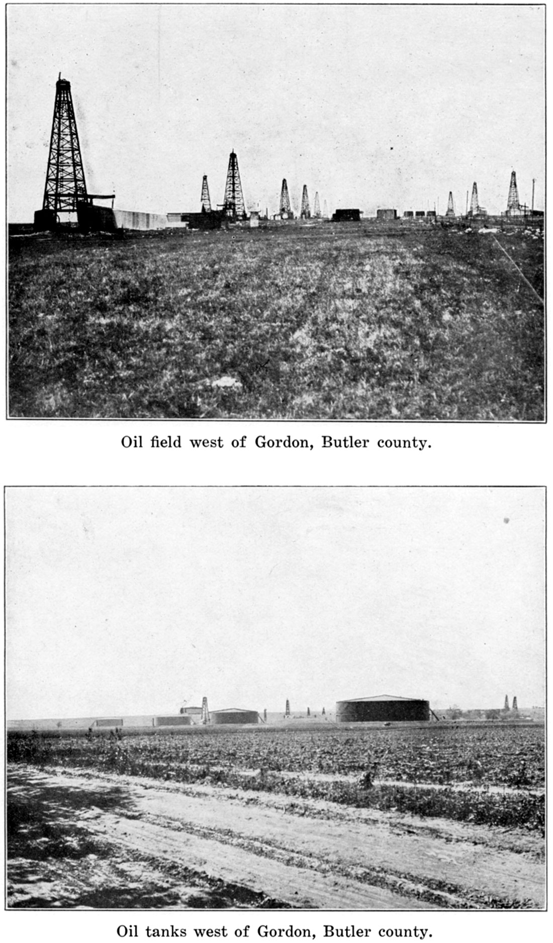
The Augusta-Gordon pool, which extends from north of Augusta to the vicinity of Gordon, is also noted for its gushers. This field was first developed on account of its gas, but in the last two years it has advanced to front rank among the Midcontinent oil fields. The two most important sands in this field are the Kramer sand, at about 2,000 feet depth, and the Varner, about 400 feet deeper. The Kramer sand thins out to the south. Much trouble has been caused by water flooding the producing sands in this pool.
The Douglass pool, north of Douglass, is the southernmost oil field in the county. It has been developed more recently than either of those mentioned above and at present is of small extent, but contains a number of wells with large production. The chief sand is reached at about 1,800 feet.
The other small pools in the county, while frequently containing a few wells with good production, are not of sufficient importance, as compared with those already described, to be discussed in any detail here.
The oil-field activity in Kansas in the last two years has centered in Butler county, principally in the El Dorado and Augusta districts. In 1916, 835 successful oil wells, credited with an average initial yield of 256 barrels each on the first day of production, were brought in during the year (U. S. Geol. Survey: Press Bulletin, July, 1917). At the beginning of 1917 there were 600 producing wells in the El Dorado district, the combined potential output of which was estimated at 15,000 barrels, and in the Augusta district there were about 200 producing wells, estimated as capable of yielding a combined daily output of 45,000 barrels. Since these figures were issued the daily output of the El Dorado field has risen until it is estimated at more than 30,000 barrels, and is very nearly equal to that of the Augusta field.
The following table of sand records and well records shows in a somewhat detailed manner the depth to the producing sands and the initial production in wells in different portions of the county.
| Record of producing sands in the Butler county fields | |||||
|---|---|---|---|---|---|
| Location | Depth to producing sand, feet |
Thickness penetrated, feet |
Initial production |
||
| Sec. | Twp. | Range | |||
| 9 | 23 | 3 | 800 | Oil, showing. | |
| 36 | 24 | 3 | 2,660 | Oil, showing. | |
| 36 | 24 | 3 | 2,654 | 48 | |
| 36 | 24 | 3 | 2,650 | 40 | |
| 36 | 24 | 3 | 2,652 | ||
| 36 | 24 | 3 | 2,644 | 26 | |
| 30 | 24 | 4 | 2,634 | 35 | |
| 31 | 24 | 4 | 2,718 | ||
| 31 | 24 | 4 | 2,664 | ||
| 31 | 24 | 4 | 2,683 | ||
| 30 | 24 | 4 | 2,317 | Oil, showing. | |
| 16 | 24 | 5 | 2,482 | Dry. | |
| 23 | 25 | 4 | 2,431 | Dry. | |
| 25 | 25 | 4 | 2,437 | ||
| 25 | 25 | 4 | 2,457 | ||
| 35 | 25 | 4 | 2,430 | ||
| 35 | 25 | 4 | 2,455 | ||
| 34 | 25 | 4 | 1,455 | 10 | Gas. |
| 35 | 25 | 4 | 2,391 | Oil, 50 bbls. | |
| 35 | 25 | 4 | 2,400 | 47 | Oil, 1,440 bbls. |
| 35 | 25 | 4 | 1,200 | Gas. | |
| 35 | 25 | 4 | 2,393 | 51 | |
| 35 | 25 | 4 | 1,483 | Gas, 2,000,000 cu. ft. | |
| 35 | 25 | 4 | 2,383 | 21 | Dry. |
| 35 | 25 | 4 | 2,415 | 40 | |
| 35 | 25 | 4 | 2,393 | ||
| 36 | 25 | 4 | 2,482 | 10 | |
| 36 | 25 | 4 | 1,482 | 11 | |
| 36 | 25 | 4 | 2,398 | 40 | Oil, 200 bbls. |
| 36 | 25 | 4 | 663 | ||
| 4 | 25 | 5 | 2,537 | Oil, 125 bbls. | |
| 5 | 25 | 5 | 720 | 17 | |
| 6 | 25 | 5 | 2,488 | ||
| 6 | 25 | 5 | 633 | 18 | |
| 8 | 25 | 5 | 665 | Oil, showing. | |
| 8 | 25 | 5 | 665 | 20 | Oil, 150 bbls. |
| 8 | 25 | 5 | 2,440 | ||
| 8 | 25 | 5 | 665 | ||
| 1,410 | |||||
| 1,950 | |||||
| 2,435 | |||||
| 15 | 25 | 5 | 2,526 | 50 | Oil, 1,000 bbls. |
| 15 | 25 | 5 | 2,502 | 50 | |
| 16 | 25 | 5 | 600 | Oil, 25 bbls. | |
| 17 | 25 | 5 | 570 | 12 | |
| 2,464 | 15 | ||||
| 17 | 25 | 5 | 827 | Gas, 4,000,000 cu. ft. | |
| 21 | 25 | 5 | 627 | 11 | |
| 21 | 25 | 5 | 623 | 21 | Oil, 15 bbls. |
| 21 | 25 | 5 | 1,215 | Gas, 16,000,000 cu. ft. | |
| 21 | 25 | 5 | 623 | 21 | Oil, 15 bbls. |
| 22 | 25 | 5 | 2,643 | 8 | |
| 22 | 25 | 5 | 616 | ||
| 22 | 25 | 5 | 2,540 | 17 | Oil, 250 bbls. |
| 22 | 25 | 5 | 2,624 | 86 | Oil, 600 bbls. |
| 22 | 25 | 5 | 2,626 | 41 | |
| 25 | 25 | 5 | 680 | 10 | |
| 27 | 25 | 5 | 2,487 | 27 | |
| 27 | 25 | 5 | 2,556 | ||
| 27 | 25 | 5 | 2,600 | Oil, 1,000 bbls. | |
| 27 | 25 | 5 | 625 | Oil, 200 bbls. | |
| 27 | 25 | 5 | 2,456 | 27 | Oil, 225 bbls. |
| 27 | 25 | 5 | 2,525 | 35 | Oil, 100 bbls. |
| 27 | 25 | 5 | 2,730 | ||
| 27 | 25 | 5 | 2,500 | 30 | |
| 27 | 25 | 5 | 2,650 | 35 | |
| 27 | 25 | 5 | 2,703 | 30 | |
| 28 | 25 | 5 | 635 | 18 | |
| 28 | 25 | 5 | 647 | 8 | |
| 28 | 25 | 5 | 624 | 15 | |
| 28 | 25 | 5 | 621 | 36 | |
| 28 | 25 | 5 | 667 | 12 | |
| 2,465 | 28 | ||||
| 28 | 25 | 5 | 2,465 | 18 | Oil, 700 bbls. |
| 28 | 25 | 5 | 2,425 | 18 | |
| 28 | 25 | 5 | 623 | 23 | Oil, 20 bbls. |
| 28 | 25 | 5 | 635 | 18 | Oil, 20 bbls. |
| 29 | 25 | 5 | 660 | 18 | |
| 2,470 | 23 | Oil, 500 bbls. | |||
| 29 | 25 | 5 | 694 | 8 | |
| 29 | 25 | 5 | 672 | 6 | |
| 31 | 25 | 5 | 650 | 31 | Oil, 15 bbls. |
| 31 | 25 | 5 | 1,314 | Gas, 1,000,000 cu. ft. | |
| 31 | 25 | 5 | 675 | 10 | |
| 2,470 | 17 | ||||
| 31 | 25 | 5 | 655 | 25 | |
| 905 | 50 | Dry. | |||
| 1,550 | 35 | Dry. | |||
| 2,452 | 5 | Oil. | |||
| 31 | 25 | 5 | 2,456 | Oil, 200 bbls. | |
| 31 | 25 | 5 | 2,490 | Oil, 1,000 bbls. | |
| 31 | 25 | 5 | 1,505 | 5 | Gas, 10,000,000 cu. ft. |
| 31 | 25 | 5 | 1,570 | 4 | Gas, 11,000,000 cu. ft. |
| 31 | 25 | 5 | 2,460 | Oil, 500 bbls. | |
| 31 | 25 | 5 | 2,463 | ||
| 31 | 25 | 5 | 650 | 31 | Oil, 15 bbls. |
| 32 | 25 | 5 | 630 | 15 | |
| 2,460 | 13 | ||||
| 32 | 25 | 5 | 644 | 18 | |
| 2,446 | |||||
| 32 | 25 | 5 | 645 | 21 | |
| 32 | 25 | 5 | 2,478 | Oil, 50 bbls. | |
| 32 | 25 | 5 | 2,432 | ||
| 32 | 25 | 5 | 2,482 | 10 | Oil, 100 bbls. |
| 32 | 25 | 5 | 620 | 15 | |
| 33 | 25 | 5 | 2,530 | 16 | Oil, 150 bbls. |
| 33 | 25 | 5 | 615 | 20 | |
| 2,435 | 30 | ||||
| 33 | 25 | 5 | 2,000 | Oil, 150 bbls. | |
| 33 | 25 | 5 | 2,576 | Oil, 250 bbls. | |
| 33 | 25 | 5 | 2,530 | 20 | Oil, 50 bbls. |
| 33 | 25 | 5 | 790 | ||
| 33 | 25 | 5 | 2,518 | ||
| 33 | 25 | 5 | 1,093 | 17 | Gas, 1,000,000 cu. ft. |
| 34 | 25 | 5 | 2,507 | Oil, 300 bbls. | |
| 2,599 | |||||
| 34 | 25 | 5 | 2,468 | ||
| 34 | 25 | 5 | 2,485 | 17 | |
| 34 | 25 | 5 | 2,520 | 22 | |
| 34 | 25 | 5 | 2,560 | ||
| 34 | 25 | 5 | 2,485 | ||
| 2 | 25 | 6 | 2,672 | Dry. | |
| 1 | 26 | 4 | 1,690 | Gas. | |
| 2,078 | 72 | Salt sand. | |||
| 1 | 26 | 4 | 2,447 | Oil, 100 bbls. | |
| 10 | 26 | 4 | 2,391 | 24 | Oil, 100 bbls. |
| 10 | 26 | 4 | 2,404 | 24 | |
| 10 | 26 | 4 | Oil, 200 bbls. | ||
| 11 | 26 | 4 | 2,414 | 26 | Oil, 15,000 bbls. |
| 3 | 26 | 5 | 2,561 | Oil, 250 bhl a, | |
| 3 | 26 | 5 | 2,589 | ||
| 3 | 26 | 5 | 2,564 | 18 | |
| 3 | 26 | 5 | 2,608 | Oil, 200 bbls. | |
| 4 | 26 | 5 | 2,590 | 8 | Oil, 100 bbls. |
| 4 | 26 | 5 | 2,597 | Oil, 200 bbls. | |
| 4 | 26 | 5 | 2,600 | 15 | Oil, 300 bbls. |
| 4 | 26 | 5 | 2,562 | 13 | Oil, 300 bbls. |
| 4 | 26 | 5 | 2,770 | 20 | Oil, 500 bbls. |
| 4 | 26 | 5 | 2,577 | Oil, 200 bbls. | |
| 4 | 26 | 5 | 2,529 | Oil, 750 bbls. | |
| 4 | 26 | 5 | 2,617 | 17 | Oil, 150 bbls. |
| 4 | 26 | 5 | 2,548 | ||
| 4 | 26 | 5 | 2,519 | ||
| 4 | 26 | 5 | 2,635 | ||
| 4 | 26 | 5 | 2,570 | ||
| 5 | 26 | 5 | 2,430 | 10 | Oil, 200 bbls. |
| 5 | 26 | 5 | 2,422 | 20 | Oil, 400 bbls. |
| 5 | 26 | 5 | 2,431 | 24 | Oil, 150 bbls. |
| 5 | 26 | 5 | 2,425 | ||
| 5 | 26 | 5 | 628 | 17 | |
| 2,435 | 17 | ||||
| 5 | 26 | 5 | 618 | 20 | |
| 5 | 26 | 5 | 630 | 23 | |
| 5 | 26 | 5 | 633 | 21 | |
| 6 | 26 | 5 | 2,424 | Oil, 75 bbls. | |
| 5 | 26 | 5 | 633 | 7 | |
| 5 | 26 | 5 | 626 | 19 | |
| 6 | 26 | 5 | 2,030 | 20 | Oil, 200 bbls. |
| 6 | 26 | 5 | 2,430 | ||
| 6 | 26 | 5 | 1,500 | Gas, 5,000,000 cu. ft. | |
| 6 | 26 | 5 | 2,470 | Oil, 70 bbls. | |
| 6 | 26 | 5 | 2,450 | Oil, 750 bbls. | |
| 6 | 26 | 5 | 1,290 | 10 | Gas. |
| 2,415 | 30 | Oil, 800 bbls. | |||
| 6 | 26 | 5 | 636 | 16 | |
| 6 | 26 | 5 | 624 | 18 | |
| 6 | 26 | 5 | 637 | 14 | |
| 7 | 26 | 5 | 2,418 | ||
| 7 | 26 | 5 | 2,407 | ||
| 7 | 26 | 5 | 2,418 | ||
| 7 | 26 | 5 | 2,453 | ||
| 7 | 26 | 5 | 700 | Gas, 2,000,000 cu. ft. | |
| 7 | 26 | 5 | 2,430 | Oil, 100 bbls. | |
| 7 | 26 | 5 | 900 | Gas, 3,000,000 cu. ft. | |
| 7 | 26 | 5 | Oil, 100 bbls. | ||
| 7 | 26 | 5 | 660 | 10 | |
| 910 | 35 | Gas. | |||
| 1,695 | 10 | Oil. | |||
| 2,431 | 60 | Oil, water. | |||
| 7 | 26 | 5 | 2,490 | Oil, 75 bbls. | |
| 8 | 26 | 5 | 2,416 | 60 | |
| 8 | 26 | 5 | 2,414 | Oil, 200 bbls. | |
| 8 | 26 | 5 | 2,424 | 50 | |
| 8 | 26 | 5 | 2,419 | 28 | |
| 17 | 26 | 5 | 1,653 | Oil, 200 bbls. | |
| 17 | 26 | 5 | 1,675 | Oil, 200 bbls. | |
| 17 | 26 | 5 | 1,690 | ||
| 17 | 26 | 5 | 1,655 | 18 | Oil, 100 bbls. |
| 17 | 26 | 5 | 1,617 | 3 | Gas. |
| 1,470 | 25 | Dry. | |||
| 1,653 | 25 | ||||
| 29 | 26 | 5 | 554 | 6 | |
| 660 | 10 | ||||
| 30 | 26 | 5 | 2,465 | Oil, 1,000 bbls. | |
| 30 | 26 | 5 | 2,605 | ||
| 22 | 27 | 3 | 2,750 | Showing. | |
| 9 | 27 | 4 | 2,337 | Oil, 150 bbls. | |
| 9 | 27 | 4 | 1,655 | 65 | Gas. |
| 9 | 27 | 4 | 1957 | Kramer | |
| 1,130 | 120 | Gas. | |||
| 1,675 | 15 | ||||
| 1,962 | Kramer | Oil, 50 bbls. | |||
| 9 | 27 | 4 | 2,444 | 36 | |
| 2,505 | 30 | ||||
| 9 | 27 | 4 | 1,970 | 65 | Oil, 400 bbls. |
| 9 | 27 | 4 | 2,384 | 15 | Oil, 550 bbls. |
| 9 | 27 | 4 | 1,950 | Oil, 100 bbls. | |
| 10 | 27 | 4 | 2,467 | Oil, 200 bbls. | |
| 10 | 27 | 4 | 2,430 | 60 | Oil, 250 bbls. |
| 10 | 27 | 4 | 1,175 | 48 | Gas. |
| 1,980 | 55 Kramer | ||||
| 10 | 27 | 4 | 2,579 | Oil, 200 bbls. | |
| 10 | 27 | 4 | 2,430 | Oil, 1,200 bbls. | |
| 10 | 27 | 4 | 1,965 | ||
| 10 | 27 | 4 | 1,950 | Oil, 75 bbls. | |
| 10 | 27 | 4 | 2,447 | 50 | Oil, 600 bbls. |
| 15 | 27 | 4 | 1,395 | 10 | Gas. |
| 2,005 | Kramer | ||||
| 2,472 | 8 Varner | ||||
| 15 | 27 | 4 | 2,005 | ||
| 2,480 | 16 | ||||
| 15 | 27 | 4 | 2,491 | Oil, 200 bbls. | |
| 15 | 27 | 4 | 2,588 | Oil, 550 bbls. | |
| 16 | 27 | 4 | 2,438 | 85 | Oil, 500 bbls. |
| 16 | 27 | 4 | 1,191 | Oil, 125 bbls. | |
| 16 | 27 | 4 | 3,535 | Showing oil. | |
| 16 | 27 | 4 | 2,477 | Oil, 40 bbls. | |
| 16 | 27 | 4 | 2,454 | Oil, 500 bbls. | |
| 16 | 27 | 4 | 1,950 | Oil, 400 bbls. | |
| 16 | 27 | 4 | 2,570 | Oil, 40 bbls. | |
| 16 | 27 | 4 | 2,517 | Oil, 100 bbls. | |
| 16 | 27 | 4 | 2,389 | 28 | Oil, 400 bbls. |
| 21 | 27 | 4 | 1,983 | Oil, 35 bbls. | |
| 21 | 27 | 4 | 1,930 | Oil, 200 bbls. | |
| 21 | 27 | 4 | 2,334 | Oil, 350 bbls. | |
| 21 | 27 | 4 | 2,350 | Oil, 350 bbls. | |
| 21 | 27 | 4 | 2,330 | Oil, 150 bbls. | |
| 21 | 27 | 4 | 2,360 | Oil, 75 bbls. | |
| 21 | 27 | 4 | 2,009 | Oil, 50 bbls. | |
| 21 | 27 | 4 | 1,960 | Oil, 50 bbls. | |
| 21 | 27 | 4 | 2,333 | Oil, 250 bbls. | |
| 21 | 27 | 4 | 2,400 | Oil, 3,000 bbls. | |
| 21 | 27 | 4 | 2,315 | 31 | Oil, 3,300 bbls. |
| 21 | 27 | 4 | 1,445 | Gas. | |
| 1,920 | Kramer | ||||
| 2,327 | 42 Varner | Oil, 250 bbls. | |||
| 21 | 27 | 4 | 1,905 | 35 Kramer | |
| 2,300 | 12 Varner | ||||
| 21 | 27 | 4 | 2,614 | Oil, 200 bbls. | |
| 21 | 27 | 4 | 1,916 | Oil, 40 bbls. | |
| 21 | 27 | 4 | 2,015 | Oil, 85 bbls. | |
| 21 | 27 | 4 | 2,035 | Oil, 35 bbls. | |
| 21 | 27 | 4 | 2,329 | Oil, 1,200 bbls. | |
| 27 | 27 | 4 | 1,340 | 10 | Gas. |
| 2,015 | 10 Kramer | Oil, showing. | |||
| 2,362 | 17 Varner | ||||
| 2,422 | 15 | Oil, 1,200 bbls. | |||
| 28 | 27 | 4 | 2,417 | 43 | Oil, 250 bbls. |
| 28 | 27 | 4 | 1,370 | 45 | Gas. |
| 2,416 | 60 | Oil, 1,900 bbls. | |||
| 28 | 27 | 4 | 1,920 | Kramer | |
| 2,320 | 35 Varner | ||||
| 28 | 27 | 4 | 1,978 | Oil, 60 bbls. | |
| 28 | 27 | 4 | 1,950 | Oil, 50 bbls. | |
| 28 | 27 | 4 | 2,400 | 28 | Oil, 100 bbls. |
| 28 | 27 | 4 | 2,326 | Oil, 2,000 bbls. | |
| 28 | 27 | 4 | 2,369 | 75 | Oil, 2,000 bbls. |
| 28 | 27 | 4 | 2,370 | 85 | Oil, 2,400 bbls. |
| 35 | 27 | 4 | 2,084 | ||
| 35 | 27 | 4 | 2,060 | Oil, 100 bbls. | |
| 35 | 27 | 4 | 2,547 | Oil, 150 bbls. | |
| 2 | 27 | 5 | 2,550 | 15 | Oil, showing. |
| 23 | 27 | 7 | 2,100 | 45 | Oil, showing. |
| 2,235 | 15 | Oil, showing. | |||
| 2,652 | 75 | Oil, showing. | |||
| 2 | 28 | 4 | 2,555 | 50 | Oil, 150 bbls. |
| 2 | 28 | 4 | 2,570 | 16 | Oil, 600 bbls. |
| 2 | 28 | 4 | 2,600 | Oil, 60 bbls. | |
| 2 | 28 | 4 | 2,570 | 33 | Oil, 240 bbls. |
| 3 | 28 | 4 | 2,575 | Oil, 500 bbls. | |
| 3 | 28 | 4 | 2,587 | 11 | Oil, 100 bbls. |
| 3 | 28 | 4 | 2,600 | 13 | Oil, 200 bbls. |
| 3 | 28 | 4 | 2,581 | 14 | Oil, 150 bbls. |
| 8 | 28 | 4 | 2,371 | Oil, 250 bbls. | |
| 8 | 28 | 4 | 2,514 | 23 | Oil, 240 bbls. |
| 8 | 28 | 4 | 2,390 | Oil, 200 bbls. | |
| 8 | 28 | 4 | 2,515 | 15 | Oil, 75 bbls. |
| 8 | 28 | 4 | 2,413 | 59 | Oil, 100 bbls. |
| 8 | 28 | 4 | 2,421 | Oil, | 175 bbls. |
| 8 | 28 | 4 | 2,396 | Oil, 40 bbls. | |
| 9 | 28 | 4 | 2,800 | Oil, 150 bbls. | |
| 9 | 28 | 4 | 1,777 | 16 | Oil, 100 bbls. |
| 9 | 28 | 4 | 2,488 | Oil, 1,000 bbls. | |
| 10 | 28 | 4 | 2,400 | Oil, 300 bbls. | |
| 10 | 28 | 4 | 2,527 | Oil, 100 bbls. | |
| 10 | 28 | 4 | 1,480 | 30 | Gas, 2,000,000 cu. ft. |
| 2,546 | 10 | Oil, 670 bbls. | |||
| 10 | 28 | 4 | 2,478 | Oil, 350 bbls. | |
| 10 | 28 | 4 | 2,602 | 26 | Oil, 100 bbls. |
| 14 | 28 | 4 | 2,555 | Oil, 500 bbls. | |
| 15 | 28 | 4 | 2,594 | 10 | Oil, 150 bbls. |
| 15 | 28 | 4 | 2,593 | Oil, 50 bbls. | |
| 16 | 28 | 4 | 2,544 | 22 | Oil, 100 bbls. |
| 16 | 28 | 4 | 2,469 | Oil, 250 bbls. | |
| 16 | 28 | 4 | 2,474 | Oil, 75 bbls. | |
| 16 | 28 | 4 | 2,500 | 8 | Oil, 120 bbls. |
| 16 | 28 | 4 | 1,695 | 40 | |
| 2,490 | 35 | Oil, 150 bbls. | |||
| 17 | 28 | 4 | 2,380 | Oil, 500 bbls. | |
| 17 | 28 | 4 | 2,469 | Oil, 100 bbls. | |
| 17 | 28 | 4 | 2,350 | Oil, 500 bbls. | |
| 17 | 28 | 4 | 1,340 | 55 | Big gas. |
| 2,368 | 30 | ||||
| 17 | 28 | 4 | 2,462 | 26 | Oil, 500 bbls. |
| 17 | 28 | 4 | 2,369 | 21 | Oil, 1,080 bbls. |
| 18 | 28 | 4 | 2,567 | 11 | Oil, 20 bbls. |
| 19 | 28 | 4 | 2,430 | Oil, 80 bbls. | |
| 20 | 28 | 4 | 2,497 | Oil, 350 bbls. | |
| 20 | 28 | 4 | 1,410 | Gas. | |
| 1,494 | 9 | Gas. | |||
| 20 | 28 | 4 | 1,370 | 30 | Gas. |
| 1,625 | 35 | Big gas. | |||
| 1,700 | 15 | Oil, 2,000 bbls. | |||
| 20 | 28 | 4 | 1,422 | 8 | Gas, 700,000 cu. ft. |
| 2,431 | 60 | ||||
| 21 | 28 | 4 | 1,742 | ||
| 21 | 28 | 4 | 2,478 | Oil, 100 bbls. | |
| 21 | 28 | 4 | 2,522 | Oil, 240 bbls. | |
| 21 | 28 | 3 | 2,522 | 10 | Oil, 125 bbls. |
| 22 | 28 | 4 | 1,550 | 20 | Gas. |
| 2,053 | 20 | Oil, 120 bbls. | |||
| 29 | 28 | 4 | 2,447 | Oil, 65 bbls. | |
| 29 | 28 | 4 | 2,471 | Oil, 100 bbls. | |
| 29 | 28 | 4 | 2,557 | 11 | Oil, 200 bbls. |
| 30 | 28 | 4 | 1,730 | Oil, 3,500 bbls. | |
| 31 | 28 | 4 | 2,553 | 7 | Water. |
| 12 | 29 | 3 | 1,700 | Gas. | |
| 6 | 29 | 4 | 1,805 | 25 | Gas. |
| 9 | 29 | 4 | 1,780 | Oil, 1,500 bbls. | |
| 9 | 29 | 4 | 1,788 | Oil, 250 bbls. | |
| 9 | 29 | 4 | 1,790 | 8 | Oil, 650 bbls. |
| 9 | 29 | 4 | 1,780 | 14 | Oil, 925 bbls. |
| 9 | 29 | 4 | 1,782 | Oil, 250 bbls. | |
| 18 | 29 | 4 | 1,865 | 16 | Oil, 30 bbls. |
| 13 | 29 | 5 | 2,810 | 17 | Oil, 25 |
| Wells drilled and acreage held in Butler county, 1914 to 1916, inclusive. Data from Mineral Resources of the United States, U. S. Geol. Survey. |
|||||||
|---|---|---|---|---|---|---|---|
| Year | Wells | Acreage | |||||
| Wells productive Jan. 1 |
New wells completed |
Abandoned | Fee | Lease | Total | ||
| Oil | Dry | ||||||
| 1914 | 1 | 60,108 | 60,108 | ||||
| 1915 | 1 | 19 | 4 | 104,060 | 104,060 | ||
| 1916 | 20 | 836 | 126 | ? | ? | ||
| 1917 | 730 | ||||||
| New wells completed in Butler county, 1914 to 1916, inclusive. Data compiled from Mineral Resources of the United States, U. S. Geol. Survey, and trade journals. |
||||
|---|---|---|---|---|
| Year | Oil | Gas | Dry | Total |
| 1914 | 5 | 24 | 29 | |
| 1915 | 22 | 34 | 4 | 60 |
| 1916 | 836 | 35 | 126 | 997 |
| Record of new wells drilled in Butler county, January, 1916, to October, 1917, inclusive, by months | |||||
|---|---|---|---|---|---|
| Month | New wells completed |
Total initial daily production, in barrels |
|||
| Oil | Gas | Dry | Total | ||
| 1916 | |||||
| January | 9 | 1 | 10 | 645 | |
| February | 15 | 1 | 3 | 19 | 1,380 |
| March | 53 | 3 | 8 | 64 | 3,130 |
| April | 58 | 13 | 71 | 5,920 | |
| May | 113 | 3 | 16 | 132 | 10,810 |
| June | 111 | 3 | 15 | 129 | 28,794 |
| July | 70 | 6 | 2 | 78 | 23,050 |
| August | 108 | 3 | 17 | 128 | 28,915 |
| September | 94 | 4 | 17 | 115 | 48,160 |
| October | 81 | 7 | 88 | 34,184 | |
| November | 74 | 1 | 19 | 94 | 18,295 |
| December | 50 | 10 | 9 | 69 | 11,315 |
| Totals | 836 | 35 | 126 | 997 | 214,598 |
| 1917 | |||||
| January | 48 | 2 | 4 | 54 | 15,350 |
| February | 71 | 4 | 18 | 93 | 12,020 |
| March | 69 | 3 | 3 | 75 | 14,870 |
| April | 63 | 3 | 6 | 72 | 11,165 |
| May | 55 | 2 | 11 | 68 | 10,470 |
| June | 81 | 1 | 6 | 88 | 24,225 |
| July | 89 | 2 | 21 | 112 | 35,440 |
| August | 122 | 32 | 154 | 38,302 | |
| September | 76 | 2 | 7 | 85 | 58,035 |
| October | 143 | 16 | 159 | 40,147 | |
| Totals | 817 | 19 | 124 | 960 | 260,024 |
| Record of George Parsley well No. 1, Sec. 23, T. 25 S., R. 4 E., west of El Dorado. |
||
|---|---|---|
| Stratum | Thickness, feet |
Depth, feet |
| Limestone | 25 | 25 |
| Shale | 25 | 50 |
| Sandstone | 20 | 70 |
| Shale | 10 | 80 |
| Sandstone | 10 | 90 |
| Limestone | 5 | 95 |
| Shale | 65 | 160 |
| Limestone | 25 | 185 |
| Red rock | 5 | 190 |
| Limestone | 30 | 220 |
| Red Rock | 10 | 230 |
| Limestone | 40 | 270 |
| Shale | 135 | 405 |
| Sandstone (water) | 20 | 425 |
| Shale | 95 | 520 |
| Limestone | 20 | 540 |
| Shale | 10 | 550 |
| Limestone | 10 | 560 |
| Shale | 55 | 615 |
| Sandstone (water) | 15 | 630 |
| Shale | 40 | 670 |
| Red rock | 15 | 685 |
| Shale | 45 | 730 |
| Sandstone (water) | 25 | 755 |
| Shale | 150 | 905 |
| Limestone | 40 | 945 |
| Shale | 125 | 970 |
| Limestone | 20 | 990 |
| Shale | 45 | 1,035 |
| Limestone | 2 | 1,037 |
| Sandstone | 3 | 1,040 |
| Shale | 45 | 1,085 |
| Limestone | 20 | 1,105 |
| Shale | 10 | 1,115 |
| Limestone | 20 | 1,135 |
| Shale | 10 | 1,145 |
| Limestone | 10 | 1,155 |
| Shale | 5 | 1,160 |
| Limestone | 45 | 1,205 |
| Shale | 35 | 1,240 |
| Limestone | 40 | 1,280 |
| Shale (water) | 20 | 1,300 |
| Limestone | 50 | 1,350 |
| Shale | 45 | 1,395 |
| Limestone | 20 | 1,415 |
| Shale | 35 | 1,450 |
| Limestone | 15 | 1,465 |
| Shale | 25 | 1,485 |
| Limestone | 5 | 1,490 |
| Shale | 30 | 1,520 |
| Sandstone | 20 | 1,540 |
| Limestone | 38 | 1,578 |
| Sandstone | 7 | 1,585 |
| Shale | 33 | 1,618 |
| Sandstone | 5 | 1,623 |
| Shale | 15 | 1,638 |
| Limestone | 20 | 1,658 |
| Shale | 55 | 1,713 |
| Shale | 5 | 1,718 |
| Limestone (water) | 151 | 1,869 |
| Shale | 132 | 2,001 |
| Limestone | 17 | 2,018 |
| Sandstone (water) | 6 | 2,024 |
| Limestone | 110 | 2,134 |
| Shale | 6 | 2,140 |
| Sandstone | 7 | 2,147 |
| Shale | 5 | 2,152 |
| Limestone | 6 | 2,158 |
| Shale | 60 | 2,218 |
| Limestone | 15 | 2,233 |
| Shale | 5 | 2,238 |
| Limestone | 5 | 2,243 |
| Sandstone | 5 | 2,248 |
| Shale | 20 | 2,268 |
| Sandstone | 5 | 2,273 |
| Shale | 20 | 2,293 |
| Limestone | 7 | 2,300 |
| Shale | 50 | 2,350 |
| Limestone | 10 | 2,360 |
| Shale | 80 | 2,440 |
| Limestone | 5 | 2,445 |
| Shale | 50 | 2,495 |
| Limestone | 8 | 2,503 |
| Shale | 16 | 2,519 |
| Limestone | 16 | 2,535 |
| Sandstone | 18 | 2,553 |
| Limestone | 20 | 2,573 |
| Shale | 10 | 2,583 |
| Limestone | 30 | 2,613 |
| Shale | 40 | 2,653 |
| Limestone | 20 | 2,673 |
| Shale | 30 | 2,703 |
| Limestone | 10 | 2,713 |
| Shale | 31 | 2,744 |
| Sandstone | 13 | 2,757 |
| Record of well near Augusta, Sec. 28, T. 27 S., R. 4 E. |
||
|---|---|---|
| Stratum | Thickness, feet |
Depth, feet |
| Soil | 10 | 10 |
| Shale | 10 | 20 |
| Sandstone | 10 | 30 |
| Shale | 40 | 70 |
| Sandstone (water) | 10 | 80 |
| Shale | 140 | 220 |
| Limestone | 10 | 230 |
| Shale | 190 | 420 |
| Sandstone | 15 | 435 |
| Shale | 135 | 570 |
| Sandstone (water) | 30 | 600 |
| Shale | 100 | 700 |
| Limestone | 10 | 710 |
| Shale | 180 | 890 |
| Limestone | 20 | 910 |
| Shale | 115 | 1,025 |
| Limestone | 10 | 1,035 |
| Shale | 5 | 1,040 |
| Limestone | 50 | 1,090 |
| Shale (water) | 20 | 1,110 |
| Limestone | 35 | 1,145 |
| Shale | 0 | 1,155 |
| Limestone | 55 | 1,210 |
| Shale | 20 | 1,230 |
| Sandstone | 30 | 1,260 |
| Shale | 5 | 1,265 |
| Limestone | 5 | 1,270 |
| Shale | 50 | 1,320 |
| Limestone | 5 | 1,325 |
| Shale | 15 | 1,340 |
| Limestone | 15 | 1,355 |
| Shale | 85 | 1,440 |
| Limestone | 15 | 1,455 |
| Shale | 10 | 1,465 |
| Gas sand | 10 | 1,475 |
| Shale | 75 | 1,550 |
| Limestone | 20 | 1,570 |
| Shale | 45 | 1,615 |
| Limestone | 155 | 1,770 |
| Shale | 150 | 1,920 |
| Sandstone (Kramer) | 190 | 2,110 |
| Shale | 210 | 2,320 |
| Sandstone (Varner) | 30 | 2,355 |
Plate XXX—A. Panoramic view looking southeast on Trapshooter lease, sec. 11, T. 26 S., R. 4 E., El Dorado field, Butler county, July, 1917. B. The Churchyard oil field (sec. 27, T. 28 S., R. 4 E.), Butler county.
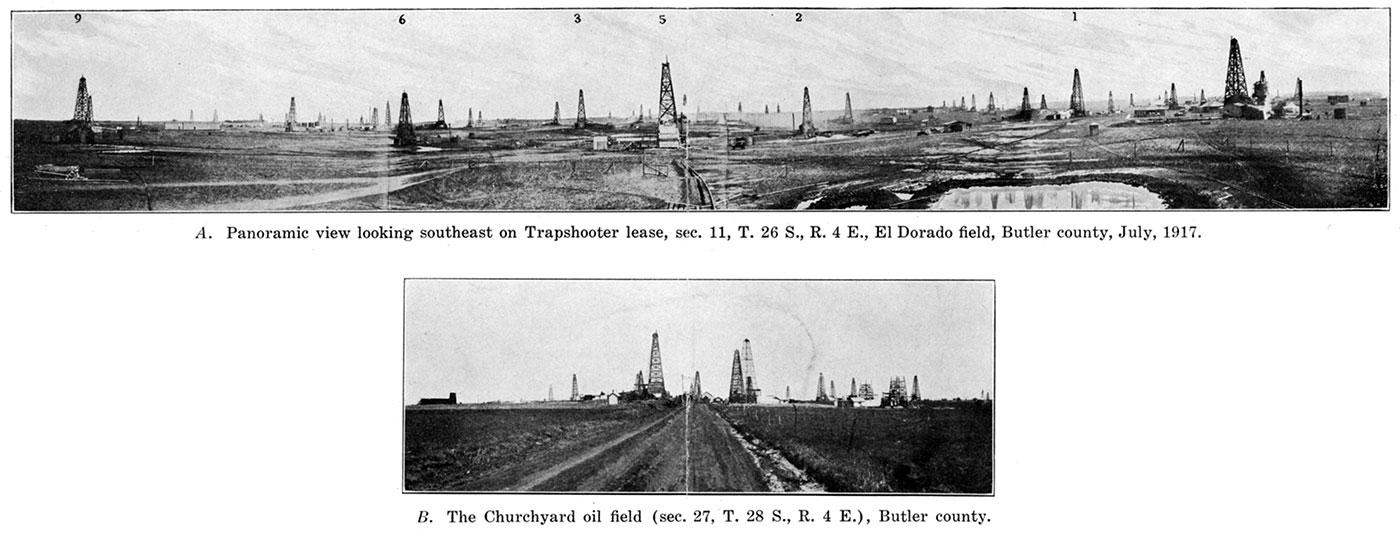
Plate XXXI—Trapshooter well No. 2, flowing 12,000 barrels a day from a six-inch pipe, June 2, 1917. Sec. 11, T. 26 S., R. 4 E., El Dorado field, Butler county. (Photos by L. J. Pepperberg.)
Plate XXXII—A. Oil field west of Gordon, Butler county. B. Oil tanks west of Gordon, Butler county.
| Record of the H. W. Hardenbower well No. 1, Sec. 5, T. 29 S., R. 4 E., near Douglass. |
||
|---|---|---|
| Stratum | Thickness, feet |
Depth, feet |
| Soil | 10 | 10 |
| Clay, yellow, and gravel | 20 | 30 |
| Limestone, sandy (water) | 65 | 95 |
| Shale, blue | 10 | 105 |
| Limestone | 5 | 110 |
| Shale, blue | 25 | 135 |
| Red rock | 10 | 145 |
| Limestone | 35 | 180 |
| Shale, blue | 5 | 185 |
| Red rock | 5 | 190 |
| Shale, white, fossiliferous | 80 | 270 |
| Limestone | 5 | 275 |
| Shale, dark | 5 | 280 |
| Shale, blue | 20 | 300 |
| Limestone | 10 | 310 |
| Shale, black | 10 | 320 |
| Limestone | 20 | 340 |
| Shale, white | 20 | 360 |
| Limestone | 5 | 365 |
| Shale | 40 | 405 |
| Limestone | 10 | 415 |
| Shale | 5 | 420 |
| Limestone | 75 | 495 |
| Shale, blue | 5 | 500 |
| Limestone, hard | 15 | 515 |
| Shale | 30 | 545 |
| Limestone | 5 | 550 |
| Shale, brown | 60 | 610 |
| Limestone | 5 | 615 |
| Red rock | 5 | 620 |
| Shale, white | 28 | 648 |
| Limestone, hard | 4 | 652 |
| Shale, white | 33 | 685 |
| Shale, blue | 35 | 720 |
| Sandstone | 5 | 725 |
| Shale, blue | 75 | 800 |
| Limestone | 10 | 810 |
| Shale, blue | 15 | 825 |
| Limestone | 5 | 830 |
| Shale, blue | 25 | 855 |
| Limestone | 5 | 860 |
| Shale, white | 10 | 870 |
| Limestone | 10 | 880 |
| Shale, blue | 5 | 885 |
| Limestone | 10 | 895 |
| Shale, white | 20 | 915 |
| Sandstone | 5 | 920 |
| Shale, brown | 35 | 955 |
| Limestone | 5 | 960 |
| Shale, blue | 35 | 995 |
| Limestone | 60 | 1,055 |
| Shale, blue | 5 | 1,060 |
| Limestone | 5 | 1,065 |
| Shale | 50 | 1,115 |
| Limestone | 60 | 1,175 |
| Shale | 10 | 1,185 |
| Limestone | 35 | 1,220 |
| Shale | 15 | 1,235 |
| Limestone | 5 | 1,240 |
| Shale, black | 5 | 1,245 |
| Limestone | 10 | 1,255 |
| Shale, white | 3 | 1,258 |
| Limestone | 17 | 1,275 |
| Shale | 15 | 1,290 |
| Limestone | 15 | 1,305 |
| Shale | 10 | 1,315 |
| Limestone | 10 | 1,325 |
| Shale | 35 | 1,360 |
| Limestone | 10 | 1,370 |
| Shale, brown | 103 | 1,473 |
| Limestone (little gas at 1,481, water) | 37 | 1,510 |
| Shale, blue | 190 | 1,700 |
| Sandstone, water | 25 | 1,725 |
| Shale | 35 | 1,760 |
| Limestone | 65 | 1,825 |
| Shale | 10 | 1,835 |
| Limestone | 45 | 1,880 |
| Shale, fossils | 25 | 1,905 |
| Limestone | 55 | 1,960 |
| Shale | 80 | 2,040 |
| Limestone | 10 | 2,050 |
| Shale | 50 | 2,100 |
| Limestone (showing of oil at 2,160) | 160 | 2,260 |
| Shale | 5 | 2,265 |
| Limestone | 20 | 2,285 |
| Shale, black | 35 | 2,320 |
| Limestone | 12 | 2,332 |
| Shale | 18 | 2,350 |
| Limestone | 5 | 2,355 |
| Shale | 80 | 2,435 |
| Limestone | 15 | 2,450 |
| Shale, black | 10 | 2,460 |
| Limestone | 25 | 2,485 |
| Shale | 5 | 2,490 |
| Limestone | 5 | 2,495 |
| Shale | 10 | 2,505 |
| Limestone | 5 | 2,510 |
| Shale | 5 | 2.515 |
| Limestone, sandy | 10 | 2,525 |
| Shale | 35 | 2,560 |
| Limestone | 4 | 2,564 |
| Shale, black | 10 | 2,574 |
| Limestone, flinty | 6 | 2,580 |
| Shale, blue | 10 | 2,590 |
| Limestone | 14 | 2,604 |
| Shale | 6 | 2,610 |
| Limestone | 5 | 2,615 |
| Shale, white | 10 | 2,625 |
| Limestone | 5 | 2,630 |
| Shale | 5 | 2,635 |
| Limestone, sandy | 20 | 2,655 |
| Shale, blue and brown | 103 | 2,75S |
| Limestone | 7 | 2,765 |
| Shale | 70 | 2,835 |
| Limestone, sandy, cherty | 10 | 2,845 |
| Limestone | 55 | 2,900 |
| Shale | 15 | 2,915 |
| Limestone | 5 | 2,920 |
| Sandstone | 8 | 2,928 |
| Limestone, hard, sandy (water at 3,010) | 157 | 3,085 |
| Shale | 2 | 3,087 |
| Limestone, hard, sandy | 23 | 3,110 |
| Limestone, hard | 375 | 3,485 |
A record of the Lilly well No. 1 (Sec. 14, T. 23 S., R. 5 E.), near the north border of Butler county, is included in Chapter VII, on The Crystalline Rocks of Kansas. This well encountered granite at a depth of 2,331 feet.
Chase County
In Chase county are found many of the localities at which stratigraphic divisions of the Pennsylvanian and Permian strata were first studied and named (Prosser and Beede, 1904). A number of well-defined anticlinal structures have been known for a long time (Prosser and Beede, 1904). The Wabaunsee formation of the Pennsylvanian occupies the eastern and central portion of the county, and the Permian strata the western, northwestern and southwestern borders. The Permian beds include the Cottonwood limestone, Garrison limestone and shale, and the Chase formation, containing from the base upward the Wreford limestone, Matfield shale, Florence flint, Fort Riley limestone, Doyle shale, and Winfield limestone. The lower portion of the Marion formation outcrops in the western and southwestern part of the county.
Some drilling is going on in the southeastern part of Chase county, but no production is reported. Several holes have been drilled in more or less well-defined structures, but have been abandoned as dry. The most noteworthy of these are two wells a short distance south of Elmdale, which encountered granite at a depth of about 1,900 feet. (For logs of these wells, see Chapter VII.) The record of a deep well drilled in the Patton ranch in the north part of the county is given below.
| Record of Robt. Watchorn well, Patton ranch, Sec. 8, T. 18 S., R. 8 E. | |||||
|---|---|---|---|---|---|
| Stratum | Thickness, feet |
Depth, feet |
|||
| Soil | 2 | 2 | |||
| Permian system— | |||||
| Chase formation: | |||||
| Matfield shale | |||||
| Shale | 15 | 17 | |||
| Limestone | 3 | 20 | |||
| Shale, blue | 25 | 45 | |||
| Shale, red | 5 | 50 | |||
| Wreford limestone | |||||
| Limestone | 2 | 52 | |||
| Shale, red | 2 | 54 | |||
| Limestone | 22 | 76 | |||
| Council Grove formation: | |||||
| Garrison limestone and shale | |||||
| Shale, black, clayey | 7 | 83 | |||
| Shale | 183 | 266 | |||
| Cottonwood limestone | |||||
| Limestone | 8 | 274 | |||
| Pennsylvanian system— | |||||
| Wabaunsee formation: | |||||
| Eskridge shale | |||||
| Shale, black | 34 | 308 | |||
| Limestone | 2 | 310 | |||
| Shale, blue | 1 | 311 | |||
| Neva limestone (?) | |||||
| Limestone | 3 | 314 | |||
| Shale, blue | 1 | 315 | |||
| Limestone | 1 | 316 | |||
| Elmdale shale | |||||
| Shale | 83 | 399 | |||
| Limestone | 2 | 401 | |||
| Shale | 42 | 443 | |||
| Americus limestone (?) | |||||
| Limestone | 4 | 447 | |||
| Admire shale | |||||
| Shale, black | 44 | 491 | |||
| Limestone | 2 | 493 | |||
| Shale, black | 35 | 528 | |||
| Limestone | 4 | 532 | |||
| Shale (gas at 548 and 570) | 51 | 583 | |||
| Limestone | 2 | 585 | |||
| Shale | 105 | 690 | |||
| Emporia limestone | |||||
| Limestone | 18 | 708 | |||
| Shale, black | 6 | 714 | |||
| Limestone | 4 | 718 | |||
| Willard shale | |||||
| Shale, black | 13 | 731 | |||
| Limestone | 6 | 737 | |||
| Shale, black | 6 | 743 | |||
| Limestone | 4 | 747 | |||
| Shale, black | 10 | 757 | |||
| Burlingame limestone | |||||
| Limestone | 8 | 765 | |||
| Shawnee formation: | |||||
| Scranton shale | |||||
| Shale, black | 25 | 790 | |||
| Limestone | 5 | 795 | |||
| Shale | 88 | 883 | |||
| Limestone | 3 | 886 | |||
| Shale, black | 4 | 890 | |||
| Limestone | 5 | 895 | |||
| Shale, black | 102 | 997 | |||
| Howard limestone (?) | |||||
| Limestone | 6 | 1,003 | |||
| Severy shale (?) | |||||
| Shale, black | 52 | 1,055 | |||
| Limestone | 5 | 1,060 | |||
| Shale, black | 36 | 1,096 | |||
| Topeka limestone | |||||
| Limestone | 7 | 1,103 | |||
| Calhoun shale | |||||
| Shale, black | 18 | 1,121 | |||
| Limestone | 1 | 1,122 | |||
| Shale, black | 3 | 1,125 | |||
| Deer Creek limestone | |||||
| Limestone | 17 | 1,142 | |||
| Shale, black | 15 | 1,157 | |||
| Limestone | 13 | 1,170 | |||
| Tecumseh shale (?) | |||||
| Shale, black | 17 | 1,187 | |||
| Lecompton limestone | |||||
| Limestone | 1 | 1,188 | |||
| Shale, black | 1 | 1,192 | |||
| Limestone | 2 | 1,194 | |||
| Shale, black | 3 | 1,197 | |||
| Limestone | 3 | 1,200 | |||
| Shale, black | 2 | 1,202 | |||
| Limestone | 2 | 1,204 | |||
| Kanwaka limestone | |||||
| Shale, black | 66 | 1,270 | |||
| Douglas formation: | |||||
| Oread limestone | |||||
| Limestone | 28 | 1,298 | |||
| Shale, brown | 3 | 1,301 | |||
| Limestone | 6 | 1,307 | |||
| Shale, black | 6 | 1,313 | |||
| Limestone | 12 | 1,325 | |||
| Lawrence shale | |||||
| Shale, black | 140 | 1,465 | |||
| Iatan limestone | |||||
| Limestone (water) | 5 | 1,470 | |||
| Weston shale | |||||
| Shale, blue | 95 | 1,565 | |||
| Lansing formation: | |||||
| Stanton limestone | |||||
| Limestone | 28 | 1,593 | |||
| Vilas shale (?) | |||||
| Shale, black | 4 | 1,597 | |||
| Plattsburg limestone | |||||
| Limestone | 53 | 1,650 | |||
| Lane shale (?) | |||||
| Shale, black | 10 | 1,660 | |||
| Limestone | 10 | 1,670 | |||
| Sandstone, white | 5 | 1,675 | |||
| Kansas City formation: | |||||
| Iola limestone | |||||
| Limestone | 35 | 1,710 | |||
| Chanute shale (?) | |||||
| Sandstone, hard, white | 22 | 1,732 | |||
| Drum limestone | |||||
| Limestone | 61 | 1,793 | |||
| Cherryvale shale | |||||
| Sandstone, white (water) | 17 | 1,810 | |||
| Shale, black | 12 | 1,822 | |||
| Limestone, hard | 2 | 1,824 | |||
| Shale, black | 8 | 1,832 | |||
| Winterset and Bethany Falls limestone | |||||
| Limestone | 73 | 1,905 | |||
| Sandstone, white | 4 | 1,909 | |||
| Hertha limestone (?) | |||||
| Limestone | 8 | 1,917 | |||
| Shale, black | 4 | 1,921 | |||
| Limestone | 9 | 1,930 | |||
| Marmaton formation: | |||||
| Pleasanton shale | |||||
| Shale, shelly, black | 115 | 2,045 | |||
| Coffeyville limestone | |||||
| Limestone | 20 | 2,065 | |||
| Walnut shale | |||||
| Shale, black | 30 | 2,095 | |||
| Altamont limestone | |||||
| Limestone | 8 | 2,103 | |||
| Bandera shale | |||||
| Shale, black | 37 | 2,140 | |||
| Pawnee limestone (?) | |||||
| Limestone | 7 | 2,147 | |||
| Labette shale | |||||
| Shale | 43 | 2,190 | |||
| Fort Scott limestone | |||||
| Limestone | 6 | 2,196 | |||
| Shale, black | 30 | 2,266 | |||
| Limestone | 9 | 2,275 | |||
| Cherokee shale: | |||||
| Shale, black | 181 | 2,456 | |||
| Sandstone, salt water | 14 | 2,470 | |||
Chautauqua County
An essential part of the southeast Kansas oil fields, Chautauqua county has long been known as an oil-producing district. The county lies between the chiefly gas-producing areas farther north and the rich oil land of northern Oklahoma, and is still an important contributor to the Kansas oil yield.
The rocks of Chautauqua county belong to the Upper Pennsylvanian. In the extreme southeastern corner of the county the Lansing formation is present, across the eastern part the Douglas formation, the west central part the Shawnee formation, and along the extreme western border the Wabaunsee formation. The various members of these formations and their outcrops are shown upon the geologic map of the county which accompanies this report.
Chautauqua county's first oil and gas was found near Peru about seventeen years ago. Upon July 1, 1903, the county had 32 producing wells, but by the close of that year the number reached 151 wells. Almost all of the early production was around Peru (Haworth, Erasmus, Mineral Resources of Kansas, 1903).
The county is noted for its large number of small but steadily producing oil wells. These wells come in with a fairly large initial production in very many cases, but after they have been pumped for several months they settle down to a dependable yield of from three to five barrels daily. The fact that the county offers a fairly large production at a shallow depth makes it possible for a number of individual producers to operate without great hazard. The county map shows the location and extent of the production to date.
The producing sands of Chautauqua county are for the most part regular and consistent. However, from the nature of the formation of the sands it is not at all surprising to find them pinching out entirely here and there, causing dry holes in the midst of good production. In some localities the sands have a tendency to pinch out on the anticline and to be productive on the syncline. In some cases lack of production in the sand appears to be due to nearly complete filling of the space between the grains of the rock with cement. (See p. 247.) The greatest part of the oil comes from three fairly well-defined and persistent sands, the "Bartlesville," "Peru," and the "Red" or "Stray" sands.
The Bartlesville sand is confined almost entirely to the southern borders of the county. However, in T. 33 S., R. 9 E., a good gas well was brought in at a depth of 1,655 feet from a 65-foot sand, which may be the Bartlesville. In T. 32 S., R. 11 E., the Bartlesville sand was reached at a depth of 1,610 feet, but was barren. The sand is found about 200 feet above the Mississippian limestone.
The Peru sand is the most persistent and the best producer of the Chautauqua county sands. It is found about 300 feet above the Bartlesville and has a thickness varying from 20 to 55 feet. About 90 feet below the Peru another producing sand, the Hancock, is sometimes encountered. However, this sand is very erratic in thickness and nonpersistent.
Around Sedan a good share of the production is obtained from the Red or Stray sand, which varies in thickness from 15 to 50 feet and is found from 125 to 200 feet above the Peru. The interval between these two sands is composed almost entirely of shale. The sands are capped, as a rule, with an impervious lime stratum 8 to 12 feet thick.
The accompanying table of sand records shows the depth at which the different sands are encountered in the various fields of the county. The difference in the depths is due to differences in casing-head elevations, westward dip, and special structures of the formations, and to irregularities due to the lenticular nature of the sand. The Prairie Pipe Line Company handles the bulk of the production in Chautauqua county.
| Record of producing sands in the Chautauqua county fields. | ||||||
|---|---|---|---|---|---|---|
| Location | Depth to producing sand, feet |
Thickness penetrated, feet |
Name of sand |
Initial production |
||
| Sec. | Twp. | Range | ||||
| 22 | 32 | 11 | 1,275 | Peru | Dry. | |
| 22 | 32 | 11 | 1,610 | Bartlesville | Dry. | |
| 5 | 33 | 9 | 1,600 | 65 | Bartlesville | Gas, 3,000,000 cu. ft. |
| 30 | 33 | 11 | 702 | 10 | Gas, 2,225,000 cu. ft. | |
| 26 | 33 | 11 | 1,154 | 33 | Peru | |
| 26 | 33 | 11 | 1,201 | 25 | Peru | |
| 26 | 33 | 11 | 1,140 | 36 | Peru | |
| 26 | 33 | 11 | 1,054 | 34 | Peru | |
| 26 | 33 | 11 | 1,131 | 35 | Peru | |
| 27 | 33 | 11 | 1,058 | 31 | Red | |
| 27 | 33 | 11 | 1,195 | 45 | Peru | |
| 33 | 33 | 11 | 980 | 40 | Red | |
| 33 | 33 | 11 | 1,164 | 27 | Peru | |
| 33 | 33 | 11 | 1,050 | 38 | Red | |
| 33 | 33 | 11 | 922 | 30 | ||
| 33 | 33 | 11 | 1,123 | 37 | ||
| 32 | 33 | 12 | 1,042 | 13 | Peru | Dry. |
| 32 | 34 | 10 | 1,500 | 40 | Oil, 100 bbls. | |
| 3 | 34 | 11 | 900 | 50 | Red | |
| 3 | 34 | 11 | 1,090 | 40 | Peru | |
| 3 | 34 | 11 | 998 | 42 | Red | |
| 3 | 34 | 11 | 1,085 | 38 | Peru | |
| 3 | 34 | 11 | 880 | 50 | Red | |
| 3 | 34 | 11 | 1,078 | 35 | Peru | |
| 3 | 34 | 11 | 890 | 50 | Red | |
| 3 | 34 | 11 | 1,085 | 18 | Peru | |
| 3 | 34 | 11 | 845 | 45 | Red | |
| 3 | 34 | 11 | 1,037 | 30 | Peru | |
| 5 | 34 | 11 | 1,044 | 34 | Peru | |
| 5 | 34 | 11 | 1,073 | 38 | ||
| 3 | 34 | 11 | 1,082 | |||
| 25 | 34 | 11 | 1,118 | 31 | ||
| 26 | 34 | 11 | 1,060 | 20 | Red | |
| 26 | 34 | 11 | 1,077 | 20 | Red | |
| 36 | 34 | 11 | 1,153 | 19 | ||
| 36 | 34 | 11 | 1,153 | 19 | ||
| 36 | 34 | 11 | 1,122 | 12 | ||
| 36 | 34 | 11 | 1,153 | 13 | ||
| 36 | 34 | 11 | 1,148 | 19 | ||
| 36 | 34 | 11 | 1,126 | 34 | ||
| 36 | 34 | 11 | 1,125 | 17 | ||
| 36 | 34 | 11 | 1,122 | 40 | ||
| 36 | 34 | 11 | 1,118 | 25 | ||
| 36 | 34 | 11 | 1,157 | 43 | ||
| 36 | 34 | 11 | 1,142 | 39 | ||
| 36 | 34 | 11 | 1,155 | 42 | ||
| 36 | 34 | 11 | 1,131 | 35 | ||
| 36 | 34 | 11 | 1,170 | 32 | ||
| 36 | 34 | 11 | 1,127 | 23 | ||
| 36 | 34 | 11 | 1,125 | 35 | ||
| 36 | 34 | 11 | 1,143 | 30 | ||
| 36 | 34 | 11 | 1,168 | 27 | ||
| 36 | 34 | 11 | 1,145 | 29 | ||
| 36 | 34 | 11 | 1,125 | 35 | ||
| 31 | 34 | 12 | 1,100-1,200 | 48-60 | ||
| 12 | 34 | 12 | 615 | 15 | ||
| 12 | 34 | 12 | 934 | 26 | ||
| 34 | 13 | 865 | 20 | Oil showing. | ||
| 15 | 34 | 13 | 1,055-800 | 16 | ||
| 18 | 35 | 9 | 1,815 | 60 | Dry. | |
| 6 | 35 | 13 | 892 | 36 | ||
| 6 | 35 | 13 | 873 | 27 | ||
| Wells drilled and acreage held in Chautauqua county, 1909 to 1916, inclusive | ||||||||
|---|---|---|---|---|---|---|---|---|
| Year | Wells | Acreage | ||||||
| Wells productive Jan. 1 |
New wells completed |
Abandoned | Fee | Lease | Total | |||
| Oil | Dry | |||||||
| 1909 | 784 | 25 | 7 | 24 | 29,969 | |||
| 1910 | 785 | 34 | 3 | 5 | 4,125 | 30,447 | 34,572 | |
| 1911 | 767 | 53 | 4 | 54 | 5,967 | 36,911 | 42,878 | |
| 1912 | 766 | 106 | 19 | 61 | 10,600 | 47,982 | 58,582 | |
| 1913 | 811 | 292 | 27 | 27 | 12,458 | 49,754 | 62,213 | |
| 1914 | 1,076 | 193 | 25 | 36 | 9,154 | 44,691 | 53,845 | |
| 1915 | 1,223 | 114 | 29 | 32 | 12,914 | 52,992 | 65,906 | |
| 1916 | 1,315 | 440 | 51 | |||||
| New wells completed in Chautauqua county, 1904 to 1916, inclusive. Data compiled from Mineral Resources of the United States, U. S. Geol. Survey. Figures for 1916 from trade journals. |
||||
|---|---|---|---|---|
| Year | Oil | Gas | Dry | Total |
| 1904 | 566 | 64 | 630 | |
| 1905 | 191 | 15 | 29 | 235 |
| 1906 | 125 | 6 | 25 | 156 |
| 1907 | 20 | 17 | 10 | 47 |
| 1908 | 16 | 5 | 3 | 24 |
| 1909 | 23 | 5 | 3 | 31 |
| 1910 | 42 | 4 | 14 | 60 |
| 1911 | 64 | 6 | 12 | 82 |
| 1912 | 182 | 12 | 28 | 222 |
| 1913 | 311 | 54 | 77 | 442 |
| 1914 | 308 | 30 | 38 | 376 |
| 1915 | 112 | 26 | 26 | 164 |
| 1916 | 440 | 20 | 51 | 511 |
| Record of new wells drilled in Chautauqua county, January, 1916, to October, 1917, inclusive, by months |
|||||
|---|---|---|---|---|---|
| Month | New wells completed |
Total initial daily production, in barrels |
|||
| Oil | Gas | Dry | Total | ||
| 1916 | |||||
| January | 31 | 2 | 33 | 717 | |
| February | 25 | 2 | 4 | 31 | 775 |
| March | 50 | 3 | 2 | 55 | 1,000 |
| April | 43 | 4 | 4 | 51 | 1,090 |
| May | 46 | 2 | 5 | 53 | 1,195 |
| June | 56 | 4 | 11 | 71 | 1,400 |
| July | 77 | 1 | 5 | 83 | 1,850 |
| August | 36 | 1 | 4 | 41 | 553 |
| September | 26 | 2 | 10 | 38 | 525 |
| October | 8 | 1 | 2 | 11 | 205 |
| November | 30 | 2 | 32 | 385 | |
| December | 12 | 12 | 330 | ||
| Totals | 440 | 20 | 51 | 511 | 9,825 |
| 1917 | |||||
| January | 16 | 2 | 18 | 375 | |
| February | 26 | 2 | 6 | 34 | 668 |
| March | 10 | 1 | 5 | 16 | 323 |
| April | 13 | 3 | 5 | 21 | 225 |
| May | 19 | 3 | 5 | 27 | 366 |
| June | 18 | 1 | 7 | 26 | 293 |
| July | 22 | 1 | 7 | 30 | 455 |
| August | 9 | 3 | 12 | 278 | |
| September | 30 | 3 | 2 | 35 | 372 |
| October | 38 | 6 | 7 | 51 | 572 |
| Total | 201 | 20 | 49 | 270 | 3,927 |
| Total and average initial daily production of new wells in Chautauqua county, 1911 to 1915, in barrels |
||
|---|---|---|
| Year | Total initial production, in barrels |
Average per well, in barrels |
| 1911 | 1,355 | 21.2 |
| 1912 | 2,963 | 16.3 |
| 1913 | 7,358 | 23.7 |
| 1914 | 5,379 | 17.5 |
| 1915 | 2.515 | 22.5 |
| Record of Moore well, Sec. 3, T. 34 S., R. 11 E., near Sedan (Haworth and Bennett, 1908, pl. 6) |
||
|---|---|---|
| Stratum | Thickness, feet |
Depth, feet |
| Shale | 25 | 25 |
| Sandstone | 25 | 50 |
| Shale | 175 | 225 |
| Sandstone | 45 | 270 |
| Shale | 195 | 465 |
| Limestone | 10 | 475 |
| Sandstone | 20 | 495 |
| Shale | 50 | 545 |
| Limestone | 10 | 555 |
| Sandstone | 20 | 575 |
| Shale | 115 | 690 |
| Sandstone | 120 | 810 |
| Shale | 55 | 865 |
| Limestone | 15 | 880 |
| Sandstone (Old Red sand) | 50 | 930 |
| Shale | 130 | 1,060 |
| Limestone | 20 | 1,080 |
| Sandstone (Peru sand) | 35 | 1,115 |
| Shale | 5 | 1,120 |
| Record of well in Sec. 18, T. 85 S., R. 9 E., southwest of Hewins. (Haworth and Bennett, 1908, pl. 6) Well begins in Burlingame limestone. |
||
|---|---|---|
| Stratum | Thickness, feet |
Depth, feet |
| Soil | 5 | 5 |
| Shale | 10 | 15 |
| Limestone | 25 | 40 |
| Shale | 20 | 60 |
| Limestone | 10 | 70 |
| Shale | 5 | 75 |
| Limestone | 20 | 95 |
| Shale | 5 | 100 |
| Limestone | 50 | 150 |
| Shale | 5 | 155 |
| Limestone | 20 | 175 |
| Shale | 5 | 180 |
| Limestone | 50 | 230 |
| Shale | 55 | 285 |
| Limestone | 15 | 300 |
| Shale | 5 | 305 |
| Limestone | 20 | 325 |
| Shale | 10 | 335 |
| Sandstone | 120 | 455 |
| Shale | 50 | 505 |
| Limestone | 10 | 515 |
| Shale | 15 | 530 |
| Sandstone | 10 | 540 |
| Limestone | 20 | 560 |
| Shale | 40 | 600 |
| Redrock | 10 | 610 |
| Sandstone | 60 | 670 |
| Shale | 30 | 700 |
| Sandstone | 90 | 790 |
| Limestone | 5 | 795 |
| Shale | 25 | 820 |
| Sandstone (water) | 55 | 875 |
| Shale | 5 | 880 |
| Sandstone | 55 | 935 |
| Shale | 5 | 940 |
| Sandstone (water) | 120 | 1,060 |
| Shale | 95 | 1,155 |
| Sandstone | 40 | 1,195 |
| Shale | 30 | 1,225 |
| Sandstone | 25 | 1,250 |
| Shale | 15 | 1,265 |
| Sandstone | 10 | 1,275 |
| Shale | 90 | 1,365 |
| Sandstone | 145 | 1,510 |
| Shale | 60 | 1,570 |
| Limestone | 80 | 1,650 |
| Shale | 90 | 1,740 |
| Limestone | 65 | 1,805 |
| Shale | 10 | 1,815 |
| Sandstone | 60 | 1,875 |
| Shale | 65 | 1,940 |
| Limestone | 230 | 2,170 |
| Shale | 130 | 2,300 |
| Limestone | 100 | 2,400 |
Cherokee County
Cherokee County, in the extreme southeastern corner of the state, is important on account of deposits of lead, zinc and coal. It is outside the area of oil and gas production.
The rocks of the county belong to the Mississippian and Pennsylvanian systems. The Mississippian area, the only outcrop of this system in Kansas, lies in the southeast corner of the county, but the Mississippian limestone extends west and north beneath the entire surface of the county. Except for a few square miles in the northwest belonging to the Marmaton formation, the entire remaining portion of Cherokee county is composed of Cherokee shale. The strata dip gently west and northwest about 20 feet per mile.
There is little prospect of much if any oil or gas development in Cherokee county, owing to the exposure of the oil-bearing formations at the surface. The oil sands of the Cherokee shale are protected by too thin and pervious a cover to form good reservoirs. In the southeast corner of the county the Pennsylvanian sands have been entirely removed, exposing the subjacent hard, nonpetroliferous Mississippian limestone. Toward the northwest, however, owing to the westward dip of the strata, conditions for oil accumulation are more favorable, and a 45-barrel oil well from a depth of 825 feet is reported in the northwestern corner of the county. Very little information is available concerning projected development work in this county.
| Record of well at Stone City (Haworth and Bennett, 1908, pl. p. 64) |
|||||
|---|---|---|---|---|---|
| Stratum | Thickness, feet |
Depth, feet |
|||
| Not reported | 300 | 300 | |||
| Pennsylvanian system— | |||||
| Cherokee shale: | |||||
| Shale, gray | 20 | 320 | |||
| Sandstone and shale, gray | 5 | 325 | |||
| Shale, black | 15 | 340 | |||
| Shale, gray, coal, 8 inches | 13 | 353 | |||
| Shale, black | 8 | 361 | |||
| Coal | 1 | 362 | |||
| Shale, black, containing pyrite | 9 | 371 | |||
| Shale, black, some flint | 5 | 376 | |||
| Mississippian system— | |||||
| Keokuk and Burlington formations: | |||||
| Flint, white, and limestone, gray | 20 | 396 | |||
| Flint, gray-mottled, some limestone | 100 | 496 | |||
| Limestone | 50 | 546 | |||
| Limestone and flint | 20 | 566 | |||
| Flint and cotton rock (decomposed flint) | 10 | 576 | |||
| Flint | 15 | 591 | |||
| Flint and zinc ore | 5 | 596 | |||
| Flint, blue, limestone and sandstone | 20 | 616 | |||
| Flint, blue, and sandstone, gray | 100 | 716 | |||
| Limestone | 80 | 796 | |||
| Ordovician system— | |||||
| Sandstone, fine grained, hard, white | 16 | 812 | |||
| Sandstone, brown | 36 | 848 | |||
| Sandstone, brown and gray | 8 | 856 | |||
Cheyenne County
This county, in the extreme northwest corner of the state lies in the High Plains region. It is traversed from southwest to northeast by the Republican river, which has cut a valley about 200 feet below the general surface of the plains. Tertiary gravels form the highlands and lie upon the Pierre shale of the Cretaceous which is exposed in the valley. The Niobrara chalk and limestone probably lie at a depth of 1,000 feet or more, but so far as known there has been no boring sufficiently deep to reach the Niobrara. The estimated depth to the Dakota sandstone is over 2,300 feet, and to any of the oil-bearing formations of the eastern part of the state, if they extend this distance westward, a depth considerably beyond the reach of the drill.
Clark County
The plains of northern Clark county are capped by Tertiary gravels which rest on Dakota sandstone of the Cretaceous in the north and on Comanchean sandstones and shales to the south. In the southern part of the county the red beds of the Permian are exposed. The depth to oil-bearing horizons of producing districts farther east is almost beyond the reach of the drill. Until oil is found in adjoining counties east of Clark county, testing for oil in this region is extremely hazardous wild-catting. Well-borings to a depth of 300 feet have been made in the red beds, but only salt water has been obtained from them.
| Record of well No. 1 of The Short Grass Oil and Gas Company, near Minneola, Kan. |
||
|---|---|---|
| Stratum | Thickness, feet |
Depth, feet |
| Soil, black, soft | 5 | 5 |
| Shale, yellow, clayey | 75 | 80 |
| Sandstone, gray | 41 | 121 |
| Gypsum, yellow | 4 | 125 |
| Red rock, soft | 5 | 130 |
| Shale, blue, soft | 143 | 273 |
| Limestone, hard, white | 2 | 275 |
| Shale, blue, soft | 10 | 285 |
| Sandstone, gray, soft | 35 | 320 |
| Shale, blue, soft | 50 | 380 |
| Red rock, soft | 45 | 425 |
| Sandstone, red, soft | 15 | 440 |
| Red rock, soft | 30 | 470 |
| Sandstone, gray, soft (water) | 15 | 485 |
| Red rock, soft | 15 | 500 |
| Sandstone, red, soft | 15 | 515 |
| Red rock, soft | 60 | 575 |
| Sandstone, gray, hard | 3 | 578 |
| Shale, white, soft | 7 | 585 |
| Red rock, soft | 35 | 620 |
| Limestone, gray, hard | 15 | 635 |
| Red rock, soft | 13 | 648 |
| Limestone, gray, hard | 12 | 660 |
| Red rock, soft | 3 | 663 |
| Limestone, gray, hard | 12 | 675 |
| Red rock, soft | 5 | 680 |
| Limestone, gray, hard | 10 | 690 |
| Salt, hard crystalline | 60 | 750 |
| Limestone, gray, hard | 15 | 765 |
| Shale, red, soft | 20 | 785 |
| Salt, hard, crystalline | 153 | 938 |
| Red rock, soft | 22 | 960 |
| Limestone, red, hard | 10 | 970 |
| Salt, hard, crystalline | 30 | 1,000 |
| Limestone, gray, hard, sandy | 8 | 1,008 |
| Red rock, soft | 7 | 1,015 |
| Limestone, red, hard | 50 | 1,065 |
| Salt, hard, crystalline | 25 | 1,090 |
| Red rock, hard, shelly | 50 | 1,140 |
| Salt, hard, crystalline | 8 | 1,148 |
| Sandstone, gray, hard | 4 | 1,152 |
| Red rook, soft | 158 | 1,310 |
| Limestone, gray, hard | 20 | 1,330 |
| Red rock, soft | 10 | 1,340 |
| Limestone, gray, sandy, soft | 10 | 1,350 |
| Red rock, soft | 70 | 1,420 |
| Limestone, gray, hard | 5 | 1,425 |
| Red rock | 10 | 1,435 |
| Limestone, gray, sandy, hard | 20 | 1,455 |
| Red rock, soft | 21 | 1,476 |
| Sandstone, gray, hard | 24 | 1,500 |
| Limestone, white, hard | 8 | 1,508 |
| Shale, brown, soft | 4 | 1,512 |
| Limestone, gray, sandy, hard | 24 | 1,526 |
| Salt, hard, crystalline | 24 | 1,550 |
| Shale, brown, soft | 10 | 1,560 |
| Limestone, gray, hard | 20 | 1,580 |
| Shale, brown, soft | 75 | 1,655 |
| Red rock, soft | 15 | 1,670 |
| Limestone, gray, hard | 5 | 1,675 |
| Red rock, soft | 45 | 1,720 |
| Shale, gray, soft | 8 | 1,728 |
| Red rock, soft | 192 | 1,920 |
| Limestone, gray, soft | 5 | 1,925 |
| Shale, blue, soft | 25 | 1,950 |
| Limestone, gray, hard | 15 | 1,965 |
| Shale, blue, soft | 80 | 2,045 |
| Limestone (?), gray, hard | 485 | 2,510 |
| Shale, black, soft | 20 | 2,530 |
| Limestone, gray, hard | 15 | 2,545 |
| Shale, black, soft | 20 | 2,565 |
| Limestone, hard | 50 | 2,615 |
| Shale, black, soft | 4 | 2,619 |
| Limestone, gray, hard | 29 | 2,648 |
| Shale, black, soft | 12 | 2,660 |
| Limestone, gray, hard | 20 | 2,680 |
| Shale, light, soft | 5 | 2,685 |
| Limestone, gray, hard | 20 | 2,705 |
| Shale, brown, soft | 10 | 2,715 |
| Limestone, black, hard | 25 | 2,740 |
| Shale, black, soft | 35 | 2,770 |
| Limestone, gray, sandy, soft | 65 | 2,840 |
| Red rock, soft | 15 | 2,855 |
| Limestone, gray, hard | 65 | 2,920 |
| Shale, gray, soft | 10 | 2,930 |
| Limestone, gray, hard | 15 | 2,945 |
| Limestone, gray, sandy | 30 | 2,965 |
| Limestone, gray, hard | 35 | 3,000 |
| Shale, blue, soft | 6 | 3,006 |
| Red rock, soft | 12 | 3,018 |
| Limestone, gray, hard | 42 | 3,060 |
| Limestone, sandy, hard | 20 | 3,080 |
| Shale, black, soft | 10 | 3,090 |
| Sandstone, gray, hard | 10 | 3,100 |
| Limestone, gray, hard | 15 | 3,115 |
| Shale, blue, soft | 5 | 3,120 |
| Red rock, soft | 5 | 3,125 |
| Limestone, gray, hard | 45 | 3,170 |
| Shale | 3 | 3,173 |
| Limestone | 55 | 3,228 |
| Shale | 5 | 3,233 |
| Limestone, sandy (water) | 4 | 3,237 |
| Limestone | 23 | 3,260 |
| Red rock | 4 | 3,264 |
| Limestone | 18 | 3,282 |
| Limestone, sandy (water) | 8 | 3,290 |
| Limestone | 50 | 3,340 |
| Shale, black | 3 | 3,343 |
| Limestone | 39 | 3,382 |
| Limestone, soft (water) | 3 | 3,385 |
| Limestone | 5 | 3,390 |
| Shale, blue | 4 | 3,394 |
| Limestone, white | 51 | 3,445 |
| Limestone, blue | 8 | 3,453 |
| Limestone, gray | 17 | 3,470 |
| Limestone, sandy | 5 | 3,475 |
| Limestone, white | 5 | 3,480 |
| Sandstone, gray (water) | 10 | 3,495 |
| Limestone, dark, gray | 8 | 3,503 |
| Sandstone, gray (water) | 5 | 3,508 |
| Limestone, sandy, gray | 7 | 3,515 |
| Limestone, gray | 5 | 3,520 |
| Sandstone (water) | 5 | 3,525 |
| Shale, blue | 2 | 3,527 |
| Limestone, gray | 33 | 3,560 |
| Shale | 4 | 3,564 |
| Limestone | 6 | 3,570 |
| Sandstone (salt water) | 7 | 3,577 |
| Limestone | 23 | 3,600 |
| Red rock | 8 | 3,608 |
| Shale, blue | 7 | 3,610 |
| Limestone, gray | 13 | 3,628 |
| Shale, blue | 34 | 3,662 |
| Limestone, gray | 6 | 3,668 |
| Limestone, sandy (salt water) | 4 | 3,672 |
| Limestone, white | 8 | 3,680 |
| Shale, green | 3 | 3,683 |
| Limestone, gray | 117 | 3,800 |
Clay County
The central and eastern portions of Clay county are occupied by Permian strata which are traversed by the Republican river. Along the northern and western margins the overlying Dakota sandstone of Cretaceous age rests unconformably upon the Permian beds, which in this district are the Marion and Wellington formations described in detail in the chapter upon stratigraphy.
It is possible that oil or gas may be obtained by drilling to sufficient depth in favorable structures located in Clay county, but neither of these fuels has yet been discovered in paying amounts in this region. Until satisfactory tests have been made, drilling propositions are distinctly of the "wild-cat" type.
Cloud County
The surface rocks of Cloud county belong entirely to the Cretaceous system. The divide between Solomon and Republican rivers is capped by the Benton shale, and in the valleys Dakota sandstone is exposed. Beneath the Dakota, and not outcropping in Cloud county, are shale, sandstone and limestone of the Permian, which are probably several hundred feet thick. The rocks are in the main almost horizontal, but the structure has not been examined in detail.
Seepages of high-grade oil have been reported from Cretaceous rocks in the vicinity of Cloud county, but no commercial deposits of oil have been located. The county is practically untested with the drill.
Coffey County
The rocks of Coffey county belong entirely to the upper division of the Pennsylvanian. The southeastern portion of the county is occupied by the Douglas formation and the remainder by the Shawnee formation. The escarpment formed by the Oread limestone at the top of the Douglas is the most striking one in the county. It crosses the southeast part from southwest to northeast, passing through Burlington. The various limestone members of the Shawnee formation forms similar escarpments of smaller size, which have the same general trend. All the beds have a slight westerly dip.
The stratigraphic divisions have been studied and mapped in Coffey county, but no detailed examination of the structure of the rocks has been made. There are probably local anticlinal structures, and the oil sands of the Cherokee and other lower Pennsylvanian horizons are within easy drilling distance of the surface. To date, however, no important oil pools have been found. Comparatively little development work has been done. A few wells maintain production and some drilling is going on, but the total quantity of oil is small. The following table records the recent work in the county:
| Wells drilled and acreage held in Coffey county, 1911 to 1916, inclusive. Data from Mineral Resources of the United States, U. S. Geol. Survey. |
||||||||
|---|---|---|---|---|---|---|---|---|
| Year | Wells | Acreage | ||||||
| Wells productive Jan. 1 |
New wells completed |
Abandoned | Fee | Lease | Total | |||
| Oil | Dry | |||||||
| 1911 | 2 | 240 | 240 | |||||
| 1912 | 2 | 398 | 398 | |||||
| 1913 | 2 | 1 | 2 | 158 | 158 | |||
| 1914 | 1 | 18 | 80 | 80 | ||||
| 1915 | 19 | 4 | 1,195 | 1,195 | ||||
| 1916 | 23 | |||||||
| Record of well at Le Roy. (Haworth and Bennett, 1908, pl. 86) Location, 1 1/2 miles southeast of town, on Crotts' farm. LeRoy Oil and Gas Company. |
|||||
|---|---|---|---|---|---|
| Stratum | Thickness, feet |
Depth, feet |
|||
| Soil | 21 | 21 | |||
| Pennsylvanian system— | |||||
| Douglas formation: | |||||
| Weston shale | |||||
| Sandstone and gravel | 13 | 34 | |||
| Shale | 98 | 132 | |||
| Sandstone | 28 | 160 | |||
| Lansing formation: | |||||
| Stanton limestone | |||||
| Limestone | 16 | 176 | |||
| Vilas shale | |||||
| Shale | 4 | 180 | |||
| Plattsburg limestone | |||||
| Limestone | 28 | 208 | |||
| Lane shale | |||||
| Shale | 96 | 304 | |||
| Limestone | 16 | 320 | |||
| Shale | 14 | 334 | |||
| Kansas City formation: | |||||
| Iola limestone | |||||
| Limestone | 5 | 339 | |||
| Shale | 6 | 345 | |||
| Limestone | 41 | 386 | |||
| Chanute shale | |||||
| Sandstone | 13 | 399 | |||
| Drum limestone | |||||
| Limestone | 26 | 425 | |||
| Cherryvale shale | |||||
| Shale | 53 | 478 | |||
| Winterset limestone | |||||
| Limestone | 55 | 533 | |||
| Galesburg shale | |||||
| Shale | 4 | 537 | |||
| Bethany Falls limestone | |||||
| Limestone | 21 | 558 | |||
| Ladore shale | |||||
| Shale | 6 | 564 | |||
| Hertha limestone | |||||
| Limestone | 24 | 588 | |||
| Marmaton formation: | |||||
| Pleasanton shale | |||||
| Shale | 44 | 632 | |||
| Sandstone | 63 | 695 | |||
| Shale | 23 | 718 | |||
| Coffeyville limestone | |||||
| Limestone | 9 | 727 | |||
| Walnut shale | |||||
| Shale | 19 | 746 | |||
| Altamont limestone | |||||
| Limestone | 10 | 756 | |||
| Shale | 13 | 769 | |||
| Limestone | 9 | 778 | |||
| Bandera shale | |||||
| Shale | 38 | 816 | |||
| Sandstone | 16 | 832 | |||
| Shale | 12 | 844 | |||
| Pawnee limestone | |||||
| Limestone | 8 | 852 | |||
| Shale | 4 | 856 | |||
| Limestone | 5 | 861 | |||
| Shale | 5 | 867 | |||
| Limestone | 5 | 872 | |||
| Labette shale | |||||
| Shale (salt water) | 4 | 876 | |||
| Shale | 12 | 888 | |||
| Limestone | 4 | 892 | |||
| Shale | 20 | 912 | |||
| Fort Scott limestone | |||||
| Limestone | 3 | 915 | |||
| Shale | 7 | 922 | |||
| Limestone | 10 | 932 | |||
| Cherokee shale: | |||||
| Shale | 33 | 965 | |||
| Sandstone, (oil) | 23 | 988 | |||
| Shale | 20 | 1,008 | |||
Comanche County
The larger part of Comanche county, including almost the entire western and southern portions, is in the red-beds area of the Permian. This is a rough, more or less bad-land territory which has not been examined in detail geologically. Resting unconformably on the Permian in the north and occupying a number of square miles near the south border of the county are sandstone and shale belonging to the Comanchean. Tertiary sands and gravels cover the uplands north and east of Coldwater.
Oil-bearing strata of eastern counties are probably buried more than 4,000 feet in Comanche county, so that unless production is obtainable from higher levels drilling is a hazardous venture.
Cowley County
The rock formations of Cowley county and their major structural relations are almost identical with those in Butler county adjoining on the north. Pennsylvanian strata belonging to the Wabaunsee formation are found in the eastern one-third of the county, to the valley of Grouse creek. The remainder is occupied by beds of the lower Permian, which consists of alternating shales, sandstones and limestones. The escarpment of the Cottonwood and Wreford limestones is shown on the accompanying map of the county (Plate XXXIV). Detailed examination of the higher Permian formations in Cowley county has not yet been made.
At the present time there are three chief producing districts in the county. One lies in the vicinity of Dexter in the southeastern part of the county, a second is to the east and southeast of the town of Winfield, and a third lies just north of Arkansas City. Wells have been drilled here and there in various parts of the county, especially along Walnut river, but there is little production from them.
The producing wells of Cowley county are all very deep; many of the wells reach 3,000 feet and some 3,500 feet. One well near Dexter is reported to have produced 50 barrels daily for the past two years from a sand about 3,000 feet in depth. Higher sands at depths of about 1,450 feet and 1,700 feet are productive near Winfield. Wells from the Peacock field are reported to yield 90 to 150 barrels daily.
In the vicinity of Arkansas City wells are chiefly gas producers. Many of them record from 15,000,000 to 70,000,000 feet of gas under very strong rock pressure. The depth of the main gas sand is more than 3,200 feet, but there are a number of productive horizons at lesser depths. The following list of sand records shows the depth to various producing sands.
It is desirable to test possible oil-containing structures in this region, and development has been active in recent months. On account of the cost of drilling, fewer wells are possible and the interest of corporations with large capital is in general necessary.
The logs of two typical deep wells in Cowley county are given below:
| Record of producing sands in the Cowley county fields. | |||||
|---|---|---|---|---|---|
| Location | Depth to producing sand, feet |
Thickness penetrated, feet |
Initial production |
||
| Sec. | Twp. | Range | |||
| 6 | 31 | 4 | 2,827 | 30 | Oil, 90 bbls. |
| 7 | 32 | 4 | 615 | 10 | Gas. |
| 2,302 | 12 | Oil. | |||
| 25 | 32 | 4 | 665 | 7 | Gas. |
| 2,650 | 20 | Oil, 10 bbls. | |||
| 25 | 32 | 4 | 715 | 10 | Gas. |
| 1,475 | 15 | Oil, showing. | |||
| 1,775 | 8 | Oil. | |||
| 1,978 | 4 | Oil. | |||
| 2,128 | 34 | Oil. | |||
| 2,352 | 20 | Oil. | |||
| 26 | 32 | 4 | 620 | Gas. | |
| 36 | 32 | 4 | 1,432 | 10 | Oil, 10 bbls. |
| 36 | 32 | 4 | 1,423 | 16 | Oil. |
| 33 | 32 | 7 | 2,755 | 60 | Oil, 15 bbls. |
| 1 | 33 | 4 | 647 | 16 | Gas. |
| 2 | 33 | 4 | 790 | 30 | Dry. |
| 7 | 33 | 4 | 594 | 10 | Gas. |
| 12 | 33 | 4 | 669 | 15 | Dry. |
| 12 | 33 | 4 | 694 | 14 | Dry. |
| 12 | 33 | 4 | 572 | 11 | Gas. |
| 12 | 33 | 4 | 623 | 11 | Gas. |
| 13 | 33 | 4 | 535 | 15 | Gas. |
| 656 | 10 | Gas. | |||
| 13 | 33 | 4 | 600 | 45 | Gas. |
| 7 | 33 | 5 | 568 | 8 | Gas. |
| 3 | 33 | 6 | 2,720 | Oil. | |
| 24 | 33 | 6 | 1,010 | 10 | Gas, 9,000,000 cu. ft. |
| 2,295 | 15 | ||||
| 2,731 | 4 | ||||
| 2,774 | 9 | ||||
| 2,820 | Oil, 200 bbls. | ||||
| 18 | 33 | 6 | 2,390 | 30 | Oil, showing. |
| 2,794 | 29 | Oil. | |||
| 6 | 30 | 8 | 1,955 | 65 | Oil, showing. |
| 18 | 33 | 7 | 2,717 | 2 | Oil, 25 bbls. |
| 18 | 33 | 7 | 2,721 | 13 | |
| 18 | 33 | 7 | 2,825 | ||
| 5 | 34 | 4 | 746 | 8 | Gas. |
| 5 | 34 | 4 | 764 | 6 | Gas. |
| 5 | 34 | 4 | 775 | 5 | Gas. |
| 18 | 34 | 4 | 793 | 8 | Gas. |
| 20 | 34 | 4 | 790 | 30 | |
| 1,140 | |||||
| 1,485 | 35 | Dry. | |||
| 35 | 34 | 4 | 775 | 5 | Gas. |
| 12 | 34 | 6 | 1,030 | 58 | Gas. |
| 1,997 | 40 | Oil, 10 bbls. | |||
| 13 | 34 | 6 | 1,139 | 20 | Oil, showing. |
| 9 | 34 | 8 | 1,910 | 14 | Oil, showing. |
| 1,940 | 10 | Gas. | |||
| 4 | 35 | 4 | 460 | Gas. | |
| 1,075 | Gas. | ||||
| 1,620 | Gas. | ||||
| 1,927 | 11 | Gas, 2,000,000 cu. ft. | |||
| 11 | 35 | 5 | 1,655 | 20 | Gas. |
| 1,820 | 30 | Gas. | |||
| 8 | 35 | 7 | 1,983 | 12 | Oil, 25 bbls. |
| 16 | 35 | 7 | 1,400 | Gas, 10,000,000 cu. ft. | |
| 17 | 35 | 7 | 1,485 | Gas, 1,000,000 cu. ft. | |
| 9 | 35 | 8 | 2,375 | 5 | Oil, showing. |
| Wells drilled and acreage held in Cowley county, 1913 to 1916, inclusive. Data from Mineral Resources of the United States, U. S. Geol. Survey. |
||||||||
|---|---|---|---|---|---|---|---|---|
| Year | Wells | Acreage | ||||||
| Wells productive Jan. 1 |
New wells completed |
Abandoned | Fee | Lease | Total | |||
| Oil | Dry | |||||||
| 1913 | 2 | 10,622 | 10,622 | |||||
| 1914 | 1 | 13,965 | 13,965 | |||||
| 1915 | 1 | 6 | 20,354 | 20,354 | ||||
| 1916 | 2 | |||||||
| Record of L. S. Curry well No. 1, Sec. 36, T. 30 S., R. 3 E., east of Udall. |
||
|---|---|---|
| Stratum | Thickness, feet |
Depth, feet |
| Shale | 5 | 5 |
| Limestone | 35 | 40 |
| Shale (water) | 40 | 80 |
| Limestone (water) | 60 | 140 |
| Shale | 10 | 150 |
| Limestone | 10 | 160 |
| Shale | 50 | 210 |
| Limestone | 10 | 220 |
| Shale | 50 | 270 |
| Limestone (water) | 25 | 295 |
| Shale | 40 | 335 |
| Limestone | 10 | 345 |
| Shale | 105 | 450 |
| Limestone | 10 | 460 |
| Shale (water) | 10 | 470 |
| Limestone | 30 | 500 |
| Shale | 35 | 535 |
| Red rock | 5 | 540 |
| Limestone | 5 | 545 |
| Shale | 35 | 580 |
| Limestone | 10 | 590 |
| Shale | 50 | 640 |
| Limestone | 10 | 650 |
| Shale | 120 | 770 |
| Red rock | 5 | 775 |
| Shale | 215 | 990 |
| Limestone | 30 | 1,020 |
| Shale | 35 | 1,055 |
| Limestone | 20 | 1,075 |
| Shale | 20 | 1,095 |
| Limestone | 5 | 2,000 |
| Shale | 25 | 2,025 |
| Limestone | 5 | 2,030 |
| Shale | 60 | 2,090 |
| Limestone (water) | 70 | 2,160 |
| Shale | 70 | 2,230 |
| Limestone (water) | 130 | 2,360 |
| Shale | 40 | 2,400 |
| Limestone (water) | 35 | 2,435 |
| Shale | 5 | 2,440 |
| Limestone | 20 | 2,460 |
| Shale | 5 | 2,465 |
| Limestone | 15 | 2,480 |
| Shale | 40 | 2,520 |
| Limestone | 5 | 2,525 |
| Shale | 5 | 2,530 |
| Sandstone | 10 | 2,540 |
| Shale | 60 | 2,600 |
| Limestone | 5 | 2,605 |
| Shale | 15 | 2,620 |
| Limestone | 15 | 2,635 |
| Shale | 270 | 2,905 |
| Limestone | 5 | 2,910 |
| Sandstone (water) | 90 | 3,000 |
| Shale | 5 | 3,005 |
| Limestone | 5 | 3,010 |
| Shale | 5 | 3,015 |
| Limestone | 5 | 3,020 |
| Shale | 5 | 3,025 |
| Limestone | 5 | 3,030 |
| Shale | 90 | 3,120 |
| Sandstone (water) | 15 | 3,135 |
| Limestone | 5 | 3,140 |
| Sandstone | 15 | 3,155 |
| Shale | 155 | 3,310 |
| Limestone | 150 | 3,460 |
| Shale | 10 | 3,470 |
| Limestone | 25 | 3,495 |
| Shale | 5 | 3,500 |
| Limestone | 55 | 3,555 |
| Shale | 20 | 3,575 |
| Limestone | 10 | 3,585 |
| Shale | 25 | 3,610 |
| Shale | 10 | 3,620 |
| Shale | 15 | 3,635 |
| Limestone | 10 | 3,645 |
| Shale | 5 | 3,650 |
| Limestone | 5 | 3,655 |
| Shale | 25 | 3,680 |
| Limestone | 40 | 3,720 |
| Shale | 10 | 3,730 |
| Limestone | 20 | 3,750 |
| Shale | 30 | 3,780 |
| Limestone (water) | 15 | 3,795 |
| Shale | 45 | 3,840 |
| Sandstone | 5 | 3,845 |
| Shale | 50 | 3,895 |
| Record of well south of Dexter, Sec. 12, T. 84 S., R. 6 E. | |||
|---|---|---|---|
| Stratum | Thickness, feet |
Depth, feet |
|
| Pennsylvanian system— | |||
| Limestone | 15 | 15 | |
| Shale | 40 | 55 | |
| Limestone | 65 | 120 | |
| Shale | 20 | 140 | |
| Limestone | 20 | 160 | |
| Shale | 15 | 175 | |
| Limestone | 15 | 190 | |
| Shale | 10 | 200 | |
| Limestone | 10 | 210 | |
| Shale | 15 | 225 | |
| Limestone | 25 | 250 | |
| Shale | 25 | 275 | |
| Limestone | 15 | 290 | |
| Shale | 85 | 375 | |
| Limestone | 20 | 395 | |
| Shale | 40 | 435 | |
| Limestone | 5 | 440 | |
| Shale | 30 | 470 | |
| Limestone | 5 | 475 | |
| Shale | 25 | 500 | |
| Limestone | 5 | 505 | |
| Shale | 40 | 545 | |
| Limestone | 10 | 555 | |
| Shale | 30 | 585 | |
| Limestone | 10 | 595 | |
| Shale | 35 | 630 | |
| Limestone | 15 | 645 | |
| Shale | 75 | 720 | |
| Limestone | 10 | 730 | |
| Sandstone (water) | 5 | 735 | |
| Shale | 90 | 825 | |
| Limestone | 5 | 830 | |
| Shale | 15 | 845 | |
| Limestone | 20 | 865 | |
| Shale | 10 | 875 | |
| Limestone | 15 | 890 | |
| Shale | 10 | 900 | |
| Limestone | 10 | 910 | |
| Shale | 30 | 940 | |
| Limestone | 25 | 965 | |
| Shale | 20 | 985 | |
| Limestone | 5 | 990 | |
| Shale | 35 | 1,025 | |
| Limestone | 5 | 1,030 | |
| Sandstone (gas) | 10 | 1,040 | |
| Sandstone | 40 | 1,080 | |
| Shale | 40 | 1,120 | |
| Sandstone | 60 | 1,180 | |
| Shale | 95 | 1,275 | |
| Limestone | 5 | 1,280 | |
| Shale | 40 | 1,320 | |
| Limestone | 5 | 1,325 | |
| Shale | 45 | 1,370 | |
| Limestone | 10 | 1,380 | |
| Shale | 45 | 1,425 | |
| Limestone | 5 | 1,430 | |
| Shale | 55 | 1,485 | |
| Limestone | 35 | 1,520 | |
| Shale | 15 | 1,535 | |
| Sandstone | 15 | 1,550 | |
| Shale | 15 | 1,565 | |
| Sandstone | 75 | 1,640 | |
| Shale | 25 | 1,665 | |
| Sandstone | 10 | 1,675 | |
| Shale | 75 | 1,750 | |
| Sandstone | 5 | 1,755 | |
| Shale | 5 | 1,760 | |
| Sandstone | 20 | 1,780 | |
| Limestone | 10 | 1,790 | |
| Sandstone | 10 | 1,800 | |
| Limestone | 10 | 1,810 | |
| Shale | 5 | 1,815 | |
| Sandstone | 25 | 1,840 | |
| Shale | 90 | 1,930 | |
| Sandstone | 5 | 1,935 | |
| Limestone | 5 | 1,940 | |
| Shale | 60 | 2,000 | |
| Sandstone (oil) | 40 | 2,040 | |
| Shale | 10 | 2,050 | |
| Sandstone | 10 | 2,060 | |
| Shale | 65 | 2,125 | |
| Limestone | 5 | 2,130 | |
| Sandstone | 45 | 2,175 | |
| Shale | 20 | 2,195 | |
| Limestone | 105 | 2,300 | |
| Shale | 15 | 2,315 | |
| Limestone | 15 | 2,330 | |
| Shale | 55 | 2,385 | |
| Limestone | 15 | 2,400 | |
| Shale | 60 | 2,460 | |
| Limestone | 30 | 2,490 | |
| Shale | 25 | 2,515 | |
| Sandstone | 10 | 2,525 | |
| Shale | 10 | 2,535 | |
| Limestone | 25 | 2,560 | |
| Shale | 15 | 2,575 | |
| Limestone | 5 | 2,580 | |
| Shale | 40 | 2,620 | |
| Limestone | 5 | 2,625 | |
| Shale | 35 | 2,660 | |
| Limestone | 25 | 2,685 | |
| Shale | 40 | 2,725 | |
| Limestone | 5 | 2,730 | |
| Shale | 40 | 2,770 | |
| Limestone | 5 | 2,775 | |
| Shale | 65 | 2,840 | |
| Mississippian system— | |||
| Limestone | 330 | 3,170 | |
| Sandstone (water) | 5 | 3,175 | |
Crawford County
The geologic formations at the surface in Crawford county are the Cherokee formation, which occupies the eastern and southeastern portion of the county, and the Marmaton formation, which occupies the western and northwestern part. These make up the lower or Des Moines division of the Pennsylvanian system. The Cherokee formation in this region consists of shale and sandstone, 300 to 400 feet in thickness, and contains the porous strata in which oil and gas are chiefly found in southeastern Kansas. The overlying Marmaton formation consists of alternating beds of shale and limestone, to which separate names have been given as members (see Chapter VI). The limestones form fairly prominent escarpments, and the lines of their outcrop run in a general northeast-southwest direction. Owing to the general west dip of the strata, successively higher formations are encountered in going from the southeast to the northwest. The total thickness of the Marmaton formation is about 400 feet.
There has been comparatively little development work in Crawford county. A few oil wells are located in the southwestern corner, but their production is small. It is not likely that wells drilled in the southeastern portion of the county will find oil or gas in commercial quantity because of the thinness of the cover of possible oil-containing beds. In northwestern Crawford county the geologic conditions are like those about Mound Valley and Parsons, in Labette county. It is but a short distance to the Cherokee sands in this district, but favorable structures may contain accumulations of oil or gas.
| Record of well at Girard. (Haworth and Bennett, 1908, p. 56-66.) City well, No. 2. |
|||||
|---|---|---|---|---|---|
| Stratum | Thickness, feet |
Depth, feet |
|||
| Soil | 2 | 2 | |||
| Clay, gummy and sticky | 7 | 9 | |||
| Pennsylvanian system— | |||||
| Fort Scott limestone | |||||
| Limestone, white, without grit | 16 | 25 | |||
| Shale, dark | 3 | 28 | |||
| Limestone | 12 | 40 | |||
| Shale, black | 4 | 44 | |||
| Cherokee shale: | |||||
| Shale | 6 | 50 | |||
| Limestone, black, with pyrite | 1 | 51 | |||
| Shale, white | 9 | 60 | |||
| Shale, darker below | 50 | 110 | |||
| Shale, dark | 38 | 148 | |||
| Shale, small amount of coal | 10 | 158 | |||
| Shale, hard | 2 | 160 | |||
| Shale, small amount of coal | 15 | 175 | |||
| Shale | 36 | 211 | |||
| Shale and limestone, some grit | 1 | 212 | |||
| Shale, white | 5 | 217 | |||
| Shale, dark colored | 26 | 243 | |||
| Shale, dark | 9 | 252 | |||
| Shale | 4 | 256 | |||
| Shale, light | 5 | 261 | |||
| Shale, dark | 3 | 264 | |||
| Shale, light | 6 | 270 | |||
| Limestone, very hard | 1 | 271 | |||
| Shale, light | 1 | 272 | |||
| Limestone and shale | 3 | 275 | |||
| Shale, light | 8 | 283 | |||
| Sandstone, gritty, dark colored | 1 | 284 | |||
| Shale, dark | 16 | 300 | |||
| Sandstone, gray, soft | 2 | 302 | |||
| Shale, very sandy | 8 | 310 | |||
| Shale, light | 21 | 331 | |||
| Shale, dark | 7 | 338 | |||
| Shale, light | 31 | 369 | |||
| Shale, hard, sandy | 7 | 376 | |||
| Shale, hard, sandy, grading into sandstone | 19 | 395 | |||
| Coal | 1 | 396 | |||
| Shale, light colored | 10 | 406 | |||
| Shale, hard | 5 | 411 | |||
| Shale, light, firm | 6 | 417 | |||
| Limestone | 1 | 418 | |||
| Shale, light, firm | 8 | 426 | |||
| Shale, dark | 4 | 430 | |||
| Shale, light | 8 | 438 | |||
| Sandstone, hard | 1 | 439 | |||
| Shale, light, firm | 5 | 444 | |||
| Shale, with pyrite | 6 | 450 | |||
| Mississippian system— | |||||
| Flint, with limestone, very hard and varying little in color and texture | 211 | 661 | |||
| Limestone, almost pure, containing pyrite | 4 | 665 | |||
| Flint, blue, very hard and sharp | 2 | 667 | |||
| Limestone, with a little flint | 41 | 708 | |||
| Shale, light, containing pyrite | 18 | 726 | |||
| Shale, hard | 5 | 731 | |||
| Limestone, gray, hard toward the bottom | 9 | 740 | |||
| Shale containing pyrite | 2 | 742 | |||
| Sandstone, gray | 3 | 745 | |||
| Cambrian and Ordovician systems (?)— | |||||
| Limestone, hard | 51 | 796 | |||
| Limestone, sandy, varying in color | 12 | 808 | |||
| Limestone, almost pure | 4 | 812 | |||
| Limestone and flint | 3 | 815 | |||
| Limestone, varying in color | 16 | 831 | |||
| Limestone and flint | 6 | 837 | |||
| Limestone, white | 4 | 841 | |||
| Limestone and flint | 4 | 845 | |||
| Limestone | 8 | 853 | |||
| Flint with a little limestone | 4 | 857 | |||
| Limestone, very hard | 11 | 868 | |||
| Limestone and flint | 7 | 875 | |||
| Flint and limestone | 5 | 880 | |||
| Limestone with some flint | 10 | 890 | |||
| Flint with a little limestone | 10 | 900 | |||
| Record of well at Cherokee. (Haworth and Bennett, 1908, p. 62, 1908. Reported by W. E. Turkington.) |
|||||
|---|---|---|---|---|---|
| Stratum | Thickness, feet |
Depth, feet |
|||
| Soil and shale | 20 | 20 | |||
| Pennsylvanian system— | |||||
| Cherokee formation: | |||||
| Shale, 10 inches coal | 5 | 25 | |||
| Shale, black | 34 | 60 | |||
| Shale, slaty | 10 | 70 | |||
| Limestone, hard | 10 | 80 | |||
| Sandstone | 10 | 90 | |||
| Shale, 16 inches coal | 6 | 96 | |||
| Shale, black | 6 | 102 | |||
| Shale, slaty | 38 | 140 | |||
| Sandstone | 3 | 143 | |||
| Shale | 10 | 153 | |||
| Coal and shale | 5 | 158 | |||
| Limestone, hard | 7 | 165 | |||
| Shale and sandstone | 15 | 180 | |||
| Sandstone | 10 | 190 | |||
| Shale, black | 10 | 200 | |||
| Shale and fire clay | 15 | 215 | |||
| Shale | 10 | 225 | |||
| Sandstone and limestone | 10 | 235 | |||
| Shale, dark | 110 | 345 | |||
| Coal | 1 | 346 | |||
| Shale and pyrite | 6 | 352 | |||
| Mississippian system— | |||||
| Limestone and flint, showing oil | 4 | 356 | |||
| Limestone and flint | 6 | 362 | |||
| Limestone | 138 | 500 | |||
| Flint, hard | 30 | 530 | |||
| Limestone and sandstone | 70 | 600 | |||
| Limestone, magnesian | 50 | 650 | |||
| Flint and limestone | 25 | 675 | |||
| Limestone | 5 | 680 | |||
| Flint and sandstone | 15 | 695 | |||
| Limestone | 10 | 705 | |||
| Shale, blue | 10 | 715 | |||
| Ordovician system— | |||||
| Limestone | 30 | 745 | |||
| Sandstone (good showing of water) | 40 | 785 | |||
| Sandstone (water) | 5 | 790 | |||
| Limestone and sandstone | 75 | 865 | |||
| Limestone (water) | 10 | 885 | |||
| Flint, white, and sandstone | 10 | 885 | |||
| Limestone, sandstone, and flint | 23 | 908 | |||
Decatur County
Almost the entire area of Decatur county is covered by a mantle of Tertiary sands and gravels which obscure the structure of the underlying Cretaceous strata. The only exposures of the Cretaceous, which are in the north part of the county along Beaver and Sappa creeks, show Pierre shale and the upper beds of the Niobrara division. The Pierre shale is not thick in Decatur county, but increases in thickness toward the west. The Niobrara chalk and subjacent Benton shales have a thickness of about 900 feet. The Dakota sandstone probably lies at a depth of about 1,000 feet in the eastern part of the county, but it is considerably deeper in the highlands of the western part. Three deep wells in this county are on record. Unless oil-bearing strata occur in the Cretaceous it is hardly profitable to drill for oil in Decatur county.
| Record of well at Jennings (Darton, 1905, p. 293). This well was drilled for oil but was unsuccessful. A large volume of water was encountered in the lower sand. | |||||
|---|---|---|---|---|---|
| Stratum | Thickness, feet |
Depth, feet |
|||
| Sand and gravel | 28 | 28 | |||
| Cretaceous system— | |||||
| Pierre shale: | |||||
| Shale, black | 175 | 203 | |||
| Niobrara formation: | |||||
| Limestone, yellow | 6 | 209 | |||
| Chalk | 80 | 289 | |||
| Chalk, light gray, shaly | 150 | 439 | |||
| Chalk, dark, shaly | 80 | 519 | |||
| Chalk | 60 | 579 | |||
| Benton formation: | |||||
| Sandstone, gray, with water | 15 | 594 | |||
| Shale, black | 140 | 734 | |||
| Shale, hard, with rock layers | 20 | 754 | |||
| Shale, brown | 206 | 960 | |||
| Dakota sandstone: | |||||
| Sandstone, soft, with water | 90 | 1,050 | |||
| Record of well at Kanona. (Darton, 1905, p. 294) |
|||||
|---|---|---|---|---|---|
| Stratum | Thickness, feet |
Depth, feet |
|||
| Loam, clay and sandstone | 200 | 200 | |||
| Cretaceous system— | |||||
| Pierre shale: | |||||
| Shales, dark in upper part | 600 | 800 | |||
| Niobrara formation: | |||||
| Limestone | 140 | 940 | |||
| Shale, dark | 50 | 990 | |||
| Limestone, white | 10 | 1,000 | |||
| Chalk, shaly, light colored, with water | 100 | 1,100 | |||
| Benton formation: | |||||
| Shale, black | 50 | 1,150 | |||
| Shale, light colored | 250 | 1,400 | |||
| Sandstone, with water in small amount | 15 | 1,415 | |||
| Shale, black | 35 | 1,450 | |||
| Dakota sandstone: | |||||
| Sandstone, water in large amount | 100 | 1,550 | |||
| Shale | 45 | 1,595 | |||
| Sandstone, brown | 15 | 1,610 | |||
| Sandstone, brown, with soft fresh water | 10 | 1,620 | |||
Dickinson County
The surface rocks of Dickinson county belong chiefly to the Permian, a nearly complete section of this system being obtained from Kansas river at the east border of the county to the uplands northwest and southwest, which are occupied by the Dakota sandstone of the Cretaceous. The lowermost beds which include the limestones and shales of the Council Grove and Chase formations are found along Kansas river. In the west part of the county occur typical strata of the Marion formation.
Structures favorable for the accumulation of oil and gas have been reported from Dickinson county, but adequate tests have not yet been made of these districts. Wells drilled in the east central part of the county are of course within easiest reach of possible oil-containing reservoirs in the Pennsylvanian. Some drilling has been undertaken in the southwest, but no production is reported.
Doniphan County
The northeastern corner of Kansas lies entirely within the belt of upper Pennsylvanian outcrop, the strata of Doniphan county belonging chiefly to the Douglas formation, which occupies the east portion of the county along Missouri river, and the Shawnee formation, which covers almost all the remaining part. The escarpment formed by the Burlingame limestone at the base of the Wabaunsee formation crosses the western margin of the county at a few places. Although the depth of the base of the Pennsylvanian is not great in Doniphan county, few wells in the district have been drilled to the Cherokee sand. The structure of the rocks has not been examined in detail. Thus far no production has been obtained in the northeastern part of the state.
Douglas County
The surface rocks of Douglas county, belonging entirely to the upper series of the Pennsylvanian, exhibit a most typical development of the formations in this division. The eastern portion of the county is occupied by the Douglas formation, which is present in the valleys of Wakarusa and Kansas rivers. The Douglas, composed of alternating shale and limestone, has a thickness of about 400 feet. The escarpment formed by the Oread limestone member is the most striking topographic feature in the county. The Shawnee formation is present in the higher land in the west part of the county.
The strata of Douglas county are in places almost horizontal, but in general there is a slight dip to the west. Slight anticlinal folds are present locally, some of which are being drilled. Chief development has been in the southeastern part of the county, but attention is being given to districts farther north. Gas has been obtained in some of the wells, as in the vicinity of Eudora, but no oil production.
Edwards County
The stratified rocks of Edwards county are largely obscured by recent deposits of sand, gravel and alluvium. The valley of Arkansas river, which crosses the west portion of the county, is well filled with river deposits and the uplands to the northwest and southeast are covered by the Tertiary. Cretaceous sandstone belonging to the Dakota appears at intervals along the Arkansas and is encountered in wells drilled through the Tertiary. The underlying strata are probably red beds of the upper Permian, but no deep wells have been reported in the county.
Because of the lack of adequate rock exposures it is very difficult to determine the structure of the beds in Edwards county. Since, moreover, the depth to probable oil-containing strata is great, the region does not offer a promising field for oil and gas exploration.
Elk County
The surface rocks of Elk county belong almost wholly to the upper part of the Pennsylvanian system. A few small outliers of the Cottonwood and Wreford limestones belonging to the lowermost Permian are present near the west boundary of the county. The Pennsylvanian rocks include the Douglas formation, which occupies the eastern portion of Elk county, the Shawnee formation, which occupies the central portion, and the Wabaunsee formation, which covers the western part. There are several striking escarpments formed by the strong limestone members of these formations. The distribution of the geologic subdivisions is shpwn in the accompanying geologic map (Plate I).
The occurrence of oil or gas in Elk county has not been very well tested, but good production from shallow wells has stimulated development work greatly during the past year. By private enterprise the structure of the rocks in portions of the county has been determined and a number of more or less well-defined anticlinal folds located. Some of these which have been drilled are yielding a steady supply of oil and gas. Production is mainly from two sandy horizons, one at a depth of 500 to 700 feet, the other 1,500 to 1,700 feet. The best oil-producing district is the Longton field, which lies south and southeast of Longton. The field has a good many shallow wells producing on the average from 10 to 25 barrels per day. Another oil field smaller than that near Longton lies along the southern border of the county (T, 31 S., R. 12 E., and vicinity). Here a good producing sand is reached at depths of 600 to 700 feet, many of the wells yielding 15 to 20 barrels a day. Some of the companies which own wells producing from this shallow sand are drilling deeper in the hope that larger production may be found at greater depths. Other parts of the county in which there is production are the districts about Elk Falls and Moline. Wells in these fields are chiefly. gas producers.
The present good production in southeastern Elk county has maintained interest in leasing and drilling and there is good prospect of continued development work in various parts of the county.
| Record of producing sands in the Elk county fields | |||||
|---|---|---|---|---|---|
| Location | Depth to producing sand, feet |
Thickness penetrated, feet |
Initial production |
||
| Sec. | Twp. | Range | |||
| 29 | 29 | 13 | 1,680 | 30 | Gas, 250,000 cu. ft. |
| 1,730 | 30 | Gas, 5,000,000 cu. ft. | |||
| 2 | 30 | 10 | 1,503 | 7 | |
| 17 | 30 | 11 | 1,790 | 50 | |
| 15 | 31 | 11 | 1,157 | 4 | |
| 1,390 | 5 | ||||
| 1 | 31 | 12 | 1,040 | 21 | |
| 10 | 31 | 12 | 660 | 35 | |
| 1,055 | 20 | ||||
| 1,400 | 5 | ||||
| 1,600 | 9 | Gas, 1,250,000 cu. ft. | |||
| 34 | 31 | 12 | Oil, 60 bbls. | ||
| Near Longton | 600-650 | ||||
| Near Longton | 650-700 | 27-30 | |||
| 34 | 31 | 12 | Oil, 20 bbls. | ||
| 34 | 31 | 12 | 535-650 (a) | 30 | Oil, 15-60 bbls. |
| 5 | 31 | 13 | 1,200 | 19 | |
| 5 | 31 | 13 | 1,628 | 5 | |
| a. Average for a large number of wells. | |||||
| New wells completed in Elk county, 1904 to 1915, inclusive. Data compiled from Mineral Resources of the United States, U. S. Geol. Survey. |
||||
|---|---|---|---|---|
| Year | Oil | Gas | Dry | Total |
| 1904 | ||||
| 1905 | 9 | 3 | 4 | 16 |
| 1906 | 1 | 1 | 2 | |
| 1907 | ||||
| 1908 | ||||
| 1909 | 7 | 2 | 9 | |
| 1910 | 1 | 1 | ||
| 1911 | 4 | 4 | ||
| 1912 | ||||
| 1913 | ||||
| 1914 | 3 | 3 | ||
| 1915 | 3 | 2 | 5 | |
| Record of Mitchell well, south of Longton | |||||
|---|---|---|---|---|---|
| Stratum | Thickness, feet |
Depth, feet |
|||
| Soil, surface | 5 | 5 | |||
| Pennsylvanian system— | |||||
| Lansing formation: | |||||
| Vilas shale (?) | |||||
| Shale | 30 | 35 | |||
| Sandstone | 5 | 40 | |||
| Shale | 25 | 65 | |||
| Sandstone | 5 | 70 | |||
| Shale | 50 | 120 | |||
| Plattsburg limestone | |||||
| Limestone | 10 | 130 | |||
| Shale | 15 | 145 | |||
| Limestone | 10 | 155 | |||
| Lane shale | |||||
| Shale | 97 | 252 | |||
| Sandstone | 10 | 262 | |||
| Shale | 148 | 410 | |||
| Kansas City formation (?): | |||||
| Chanute shale | |||||
| Sandstone, shaly (salt water) | 35 | 445 | |||
| Shale | 10 | 455 | |||
| Drum limestone | |||||
| Limestone | 10 | 465 | |||
| Cherryvale shale | |||||
| Shale | 50 | 515 | |||
| Winterset limestone | |||||
| Limestone | 4 | 519 | |||
| Galesburg shale | |||||
| Shale | 3 | 522 | |||
| Bethany Falls limestone | |||||
| Limestone | 8 | 530 | |||
| Ladore shale | |||||
| Shale | 95 | 625 | |||
| Hertha limestone | |||||
| Limestone | 2 | 627 | |||
| Marmaton formation: | |||||
| Pleasanton shale | |||||
| Shale | 13 | 640 | |||
| Sandstone (salt water) | 6 | 646 | |||
| Shale | 14 | 660 | |||
| Sandstone (oil) | 35 | 695 | |||
| Shale | 5 | 700 | |||
| Coffeyville limestone | |||||
| Limestone | 15 | 715 | |||
| Walnut shale | |||||
| Shale | 5 | 720 | Altamont limestone (?) | ||
| Limestone | 65 | 785 | |||
| Bandera shale | |||||
| Shale | 5 | 790 | |||
| Pawnee limestone | |||||
| Limestone, little shale | 30 | 820 | |||
| Limestone | 13 | 833 | |||
| Shale and limestone | 9 | 842 | |||
| Labette shale | |||||
| Shale | 25 | 867 | |||
| Fort Scott limestone | |||||
| Limestone | 18 | 885 | |||
| Shale, sandy (salt water) | 5 | 890 | |||
| Limestone | 45 | 935 | |||
| Cherokee shale: | |||||
| Shale | 15 | 950 | |||
| Sandstone, shaly (salt water) | 8 | 958 | |||
| Shale | 20 | 978 | |||
| Limestone and shale | 12 | 990 | |||
| Limestone | 5 | 995 | |||
| Shale | 20 | 1,015 | |||
| Limestone | 5 | 1,020 | |||
| Shale and limestone | 8 | 1,028 | |||
| Shale | 27 | 1,055 | |||
| Sandstone (Peru) | 20 | 1,075 | |||
| Shale | 65 | 1,140 | |||
| Limestone | 20 | 1,160 | |||
| Shale | 30 | 1,190 | |||
| Sandstone (Wheeler) | 30 | 1,220 | |||
| Shale | 185 | 1,405 | |||
| Sandstone | 5 | 1,410 | |||
| Shale | 65 | 1,475 | |||
| Sandstone, shaly (salt water) | 10 | 1,485 | |||
| Shale | 115 | 1,600 | |||
| Sandstone (Bartlesville) | 8 | 1,608 | |||
| Mississippian system— | |||||
| Limestone | 7 | 1,615 | |||
Ellis County
Ellis county is situated in the west central part of the state in the belt of Cretaceous outcrop. The larger portion of the county, the east and south, is occupied by beds of the Benton formation. The highlands between Saline and Smoky Hill rivers are capped by the Niobrara formation and gravels of the Tertiary. The Dakota sandstone, which appears at the surface on Smoky Hill river in the southeast corner of the county, is encountered at depths ranging from 200 to 300 feet in eastern Ellis county and 500 to 600 feet in the highlands to the west.
The structure of the surface rocks in this region has not been examined in detail, but it is known that the strata dip gently to the northwest. It is certain that the oil-bearing formations of other parts of Kansas are very deeply buried in Ellis county, and no oil or gas indications have been reported. In 1903 a boring 1,177 feet deep was made on Smoky Hill river, 15 miles southwest of Hays. It passed through the Benton shale and Dakota sandstone and entered red beds of the upper Permian at a depth of 628 feet.
| Record of well on Smoky Hill river. (Darton, 1905, p. 295-296) |
|||||
|---|---|---|---|---|---|
| Stratum | Thickness, feet |
Depth, feet |
|||
| Soil, sandy, lime-rock fragments | 30 | 30 | |||
| Cretaceous system— | |||||
| Benton formation: | |||||
| Graneros shale | |||||
| Shale | 185 | 215 | |||
| Dakota sandstone | |||||
| Sandstone, with water | 290 | 505 | |||
| Shale, black | 40 | 545 | |||
| Sandstone, light colored, with artesian salt water | 11 | 556 | |||
| Permian system— | |||||
| Cimarron series: | |||||
| Shale, blue | 41 | 597 | |||
| Sandstone, hard, white | 3 | 600 | |||
| Shale, blue | 28 | 628 | |||
| Shale, red | 6 | 634 | |||
| Sandstone, white, artesian flow salt water | 4 | 638 | |||
| Shale, red, hard | 25 | 663 | |||
| Sandstone, white, soft, strong flow of mineral water | 6 | 669 | |||
| Shale, reddish | 3 | 672 | |||
| Sandstone, white | 2 | 674 | |||
| Shale, soft red | 29 | 703 | |||
| Sandstone, soft red, with strong flow salt water | 290 | 993 | |||
| Sandstone, reddish, "full of shells"? | 184 | 1,177 | |||
Ellsworth County
The Dakota sandstone is at or near the surface throughout this county except in the lower portions of the Smoky Hill valley to the southeast, where the underlying Permian rocks are exposed. The Benton shale occupies the higher land to the southwest and north of Smoky Hill valley. In general the rocks of Ellsworth county dill slightly to the west, but detailed examination shows the existence of a number of minor anti-. clinal structures. A number of borings have been made in the county, some specially in search of oil or gas, others to define the character of important salt beds which underlie this region. Of the wells drilled for oil and gas only some of the more recent appear to have been located with reference to geologic structure. It should be noted that the attitude of the Cretaceous rocks is not necessarily an indication of the structure of the underlying Permian and Pennsylvanian strata, for there is a pronounced unconformity at the base of the Dakota. It is probable, however, that the greatest deformation has succeeded the Cretaceous and that all the beds accordingly have been flexed in common.
Throughout the largest part of the county the Permian is within 100 or 150 feet of the surface. At depths ranging from 700 to 900 feet a thick deposit of rock salt belonging to the lower part of the Wellington formation is encountered. A boring near Ellsworth encountered a gas-bearing horizon at a depth of 1,100 feet, but so far as known neither gas nor oil has yet been found in commercial quantities.
| Record of well at Wilson. | |||||
|---|---|---|---|---|---|
| Stratum | Thickness, feet |
Depth, feet |
|||
| Soil, black, sand and clay | 175 | 175 | |||
| Cretaceous system— | |||||
| Dakota sandstone | |||||
| Sandstone | 110 | 285 | |||
| Permian system— | |||||
| Cimarron series: | |||||
| Shale, blue | 50 | 330 | |||
| Shale, red | 390 | 720 | |||
| Big Blue series: | |||||
| Wellington formation | |||||
| Shale, blue | 115 | 835 | |||
| Rock salt | 270 | 1,105 | |||
| Marion formation | |||||
| Shale, black | 20 | 1,125 | |||
| Gypsum | 10 | 1,135 | |||
| Shale, blue, and gypsum | 125 | 1,260 | |||
| Chase formation | |||||
| Limestone | 25 | 1,285 | |||
| Shale and gypsum | 60 | 1,345 | |||
| Sandstone and gas | 15 | 1,360 | |||
| Limestone | 25 | 1,385 | |||
Finney County
Finney county is almost entirely covered by Tertiary deposits of sand and gravel. The valley of Arkansas river is filled with sandy alluvium. However, in the northeastern portion of the county along the headwaters of Pawnee river, the Niobrara and Benton formations of the Cretaceous are exposed. The Dakota sandstone at the base of the Cretaceous is reached in deep wells in the southwestern and southern part of the county at about 200 feet, at Gardner about 400 feet, and in the northern and northwestern part 1,000 feet below the surface.
Little is known concerning the structure of the rocks in Finney county, and there is no surface indication of oil or gas in the region. This part of Kansas is not a good area for wild-cat prospecting.
| Record of well at Garden City. (Haworth, 1897a, p. 27) |
|||||
|---|---|---|---|---|---|
| Stratum | Thickness, feet |
Depth, feet |
|||
| Soil | 12 | 12 | |||
| Quicksand | 299 | 311 | |||
| Cretaceous system— | |||||
| Benton formation: | |||||
| Shale, black | 150 | 461 | |||
| Dakota sandstone: | |||||
| Sandstone | 5 | 466 | |||
| Shale, white | 10 | 476 | |||
| Sandstone, black | 5 | 481 | |||
| Shale | 69 | 550 | |||
Ford County
The entire area of Ford county is underlain by Dakota sandstone which dips very slightly to the northwest. The sandstone crops out, however, only in the east and north parts of the county on Arkansas river and tributaries of the Pawnee. Shales of the Benton formation are found north of Dodge City. Tertiary sands and gravels cover the Cretaceous rocks extensively and thick deposits of alluvium and dune sand occupy the valley of the Arkansas.
Some geologic reconnaissance has been done in Ford county, but the structure of the rocks is difficult to determine. The complete thickness of the Permian red beds, and in the southern part of the county perhaps the Comanchean, underlie the Cretaceous. Tests for oil in this region should be carefully located and should be very deep. At present "wild-cat" drilling in this part of the state is very hazardous.
| Record of well at Dodge City. (Reported by A. B. Reeves.) |
||
|---|---|---|
| Stratum | Thickness, feet |
Depth, feet |
| Soil, sand and gravel | 199 | 199 |
| Conglomerate | 1 | 200 |
| Shale, black | 200 | 400 |
| Sandstone | 8 | 408 |
| Shale, black | 180 | 588 |
| Sandstone | 3 | 591 |
| Shale, black | 411 | 1,002 |
Franklin County
Franklin county is located in the midst of the scarped plains of east central Kansas, its rocks belonging entirely to the Pennsylvanian system. The Kansas City formation is represented by the Iola limestone, its top member, which appears in the extreme southeast corner of the county. The succeeding Lansing formation occupies the lowlands along the valley of Osage river and tributary streams in the east and southeast parts. The Douglas formation covers the remainder of the county except for small areas along the west and northwest border, which are capped by limestones of the Shawnee formation. The distribution of these formations and their members is shown on Plates I and XXXVI.
The rocks of Franklin county have a slight general inclination to the west, but locally there are anticlinal structures, with which, in some cases at least, appear to be associated deposits of oil and gas. The structures which have been tested thus far have been located chiefly through the initiative of private interest. Many wells have been drilled with little regard to geologic conditions in the field. The chief producing districts are found in the east and northeast parts of the county in the vicinity of Rantoul, Peoria and Wellsville. They are practically continuous with the oil fields of Miami county. The wells in Franklin county are shallow, the average depth being from 600 to 800 feet, production being obtained from the sands of the Marmaton and upper Cherokee divisions.
Though none of the wells are of the "gusher" type, they are very profitable, steady producers, yielding from 5 to 40 or 50 barrels daily. Initial production ranges upward to more than 250 barrels a day. Gas is obtained in some wells, a gas well having been drilled recently near Ottawa. The oil pools in Franklin county have been developed rapidly in recent months. Detailed record of the oil sands are included with those from Miami county. A large number of dry wells, in large part located without reference to geologic conditions, have been reported from Franklin county. In general, however, there are good prospects of obtaining oil where the proper structural condition of the rocks is observed. New wells should be drilled only on the recommendation of a competent geologist.
| New wells completed in Franklin county, 1904 to 1915, inclusive. Data compiled from Mineral Resources of the United States, U. S. Geol. Survey. |
||||
|---|---|---|---|---|
| Year | Oil | Gas | Dry | Total |
| 1904 | ||||
| 1905 | 55 | 4 | 4 | 63 |
| 1906 | 63 | 1 | 8 | 72 |
| 1907 | 9 | 1 | 6 | 16 |
| 1908 | 1 | 1 | 2 | |
| 1909 | 6 | 1 | 7 | |
| 1910 | 1 | 2 | 3 | |
| 1911 | ||||
| 1912 | 18 | 18 | ||
| 1913 | 54 | 1 | 3 | 58 |
| 1914 | 163 | 32 | 30 | 225 |
| 1915 | 71 | 21 | 22 | 114 |
| Total and average initial daily production of new wells in Franklin county, 1912 to 1915, inclusive, by barrels. | ||
|---|---|---|
| Year | Total initial production, in barrels |
Average per well, in barrels |
| 1912 | 155 | 8.6 |
| 1911 | 748 | 13.9 |
| 1914 | 1,360 | 8.3 |
| 1915 | 620 | 8.7 |
| Record of well at Ottawa. (Haworth and Bennett, 1908, pl. 97) |
|||||
|---|---|---|---|---|---|
| Stratum | Thickness, feet |
Depth, feet |
|||
| Soil | 5 | 5 | |||
| Pennsylvanian system— | |||||
| Lansing formation: | |||||
| Stanton limestone | |||||
| Limestone | 12 | 17 | |||
| Vilas shale | |||||
| Shale | 5 | 22 | |||
| Plattsburg limestone | |||||
| Limestone | 43 | 65 | |||
| Lane shale | |||||
| Shale | 146 | 211 | |||
| Kansas City formation: | |||||
| Iola limestone | |||||
| Limestone | 21 | 232 | |||
| Chanute shale | |||||
| Shale | 20 | 252 | |||
| Drum limestone | |||||
| Limestone | 6 | 258 | |||
| Cherryvale shale | |||||
| Shale | 60 | 318 | |||
| Winterset limestone | |||||
| Limestone | 27 | 345 | |||
| Shale, salt water | 5 | 350 | |||
| Bethany Falls limestone | |||||
| Limestone | 31 | 381 | |||
| Shale | 3 | 384 | |||
| Hertha limestone | |||||
| Limestone and shells | 15 | 399 | |||
| Marmaton formation: | |||||
| Pleasanton shale | |||||
| Shale, white | 37 | 436 | |||
| Sandstone (gas) | 54 | 490 | |||
| Walnut shale | |||||
| Shale | 25 | 515 | |||
| Bandera shale | |||||
| Shale, sandy | 53 | 568 | |||
| Pawnee limestone | |||||
| Limestone | 15 | 583 | |||
| Labette shale | |||||
| Shale, black | 10 | 593 | |||
| Shale, white | 5 | 598 | |||
| Fort Scott limestone | |||||
| Limestone | 16 | 614 | |||
| Shale | 8 | 622 | |||
| Limestone | 18 | 640 | |||
| Cherokee formation: | |||||
| Shale, fossiliferous (salt water) | 15 | 655 | |||
| Shale, white | 10 | 665 | |||
| Sandstone (gas) | 58 | 723 | |||
| Shale and sandstone | 12 | 735 | |||
| Shale, black | 20 | 755 | |||
| Shale, white | 48 | 803 | |||
| Sandstone (oil) | 15 | 818 | |||
| Shale, fossiliferous | 27 | 845 | |||
| Sandstone | 8 | 853 | |||
| Shale and shells | 82 | 935 | |||
| Sandstone (oil and gas) | 10 | 945 | |||
| Shale | 10 | 955 | |||
| Sandstone | 27 | 982 | |||
| Shale, black | 78 | 1,060 | |||
| Mississippian limestone— | |||||
| Flint | 20 | 1,080 | |||
| Record of well No. 1 on Jonathan Crist farm. (Haworth and Bennett, 1908, pl. 6) |
|||||
|---|---|---|---|---|---|
| Stratum | Thickness, feet |
Depth, feet |
|||
| Soil, black | 4 | 4 | |||
| Pennsylvanian system— | |||||
| Douglas formation: | |||||
| Oread limestone | |||||
| Limestone, yellow | 4 | 8 | |||
| Limestone, blue | 24 | 32 | |||
| Lawrence shale | |||||
| Shale, blue | 23 | 55 | |||
| Sandstone, brown | 5 | 60 | |||
| Shale, blue | 110 | 170 | |||
| Iatan limestone | |||||
| Limestone, gray | 8 | 178 | |||
| Weston shale | |||||
| Shale, brown | 7 | 185 | |||
| Shale, gray | 8 | 193 | |||
| Shale, blue | 42 | 235 | |||
| Shale, gray | 75 | 310 | |||
| Lansing formation: | |||||
| Stanton limestone | |||||
| Limestone, white (water) | 40 | 350 | |||
| Vilas shale | |||||
| Shale, blue | 8 | 358 | |||
| Shale, black | 4 | 362 | |||
| Plattsburg limestone | |||||
| Limestone, white | 10 | 372 | |||
| Shale, blue | 18 | 390 | |||
| Limestone, white, very hard | 30 | 420 | |||
| Shale, blue | 4 | 424 | |||
| Kansas City formation: | |||||
| Iola limestone | |||||
| Limestone, gray | 40 | 464 | |||
| Chanute shale | |||||
| Shale, blue | 21 | 485 | |||
| Drum limestone | |||||
| Limestone, gray | 60 | 545 | |||
| Cherryvale shale | 12 | 557 | |||
| Shale, pinkish | 3 | 560 | |||
| Winterset limestone | |||||
| Limestone, brown | 25 | 585 | |||
| Galesburg shale | |||||
| Shale, blue | 24 | 609 | |||
| Bethany Falls limestone | |||||
| Limestone, brown | 19 | 628 | |||
| Ladore shale | |||||
| Shale, blue | 12 | 640 | |||
| Hertha limestone | |||||
| Limestone, brown | 33 | 673 | |||
| Marmaton formation: | |||||
| Pleasanton shale | |||||
| Shale, gray | 4 | 677 | |||
| Sandstone, gray (salt water) | 6 | 683 | |||
| Shale, gray | 41 | 724 | |||
| Shale, blue | 19 | 743 | |||
| Coffeyville limestone (?) | |||||
| Limestone, gray | 2 | 745 | |||
| Bandera and Walnut shale | |||||
| Shale, blue | 65 | 810 | |||
| Shale, brown | 20 | 830 | |||
| Pawnee limestone | |||||
| Limestone, brown | 11 | 841 | |||
| Labette shale | |||||
| Shale, black | 6 | 847 | |||
| Shale, blue | 18 | 865 | |||
| Fort Scott limestone | |||||
| Limestone, brown | 7 | 872 | |||
| Shale, blue | 8 | 880 | |||
| Shale, black | 8 | 888 | |||
| Limestone, brown | 6 | 894 | |||
| Cherokee shale: | |||||
| Shale, black | 12 | 906 | |||
| Shale, blue (some water) | 24 | 930 | |||
| Sandstone, gray | 30 | 960 | |||
| Shale, brown | 75 | 1,035 | |||
| Shale, blue | 45 | 1,080 | |||
| Sandstone white | 45 | 1,105 | |||
| Shale, black | 12 | 1,117 | |||
| Shale, gray | 43 | 1,160 | |||
| Shale, black | 20 | 1,180 | |||
| Sandstone, white | 82 | 1,262 | |||
| Shale, black (hole full of salt water) | 6 | 1,268 | |||
| Sandstone, white | 64 | 1,332 | |||
| Shale, black | 4 | 1,336 | |||
| Shale, light | 10 | 1,346 | |||
| Shale, black | 10 | 1,356 | |||
| Limestone, light | 3 | 1,359 | |||
| Shale, black | 41 | 1,400 | |||
| Limestone, gray | 3 | 1,403 | |||
| Shale, blue | 17 | 1,420 | |||
| Sandstone, gray | 20 | 1,440 | |||
| Sandstone, gray, hard | 16 | 1,456 | |||
| Sandstone, light, hard | 6 | 1,462 | |||
| Mississippian system— | |||||
| Limestone, light, hard | 8 | 1,470 | |||
| Sandstone, light, hard | 11 | 1,481 | |||
| Limestone, light, hard | 8 | 1,489 | |||
| Sandstone, light, hard | 10 | 1,499 | |||
| Limestone, light, hard | 178 | 1,677 | |||
| Record of Ellis well No. 8, Sec. 7, T. 18 S., R. 21 E. | |||||
|---|---|---|---|---|---|
| Stratum | Thickness, feet |
Depth, feet |
|||
| Pennsylvanian system— | |||||
| Douglas formation: | |||||
| Iatan limestone | |||||
| Limestone | 8 | 8 | |||
| Weston shale | |||||
| Shale | 25 | 33 | |||
| Lansing formation: | |||||
| Stanton and Plattsburg limestones | |||||
| Limestone | 52 | 85 | |||
| Lane shale | |||||
| Shale | 60 | 145 | |||
| Kansas City formation: | |||||
| Iola limestone | |||||
| Limestone | 20 | 165 | |||
| Shale | 20 | 185 | |||
| Limestone | 8 | 193 | |||
| Chanute shale | |||||
| Shale | 37 | 230 | |||
| Drum limestone | |||||
| Limestone | 20 | 250 | |||
| Cherryvale shale | |||||
| Shale | 8 | 258 | |||
| Winterset limestone | |||||
| Limestone | 27 | 285 | |||
| Galesburg shale | |||||
| Shale (water) | 5 | 290 | |||
| Bethany Falls limestone | |||||
| Limestone | 22 | 312 | |||
| Ladore shale | |||||
| Shale (water) | 4 | 316 | |||
| Hertha limestone | |||||
| Limestone | 14 | 330 | |||
| Marmaton formation: | |||||
| Pleasanton shale | |||||
| Shale | 150 | 480 | |||
| Coffeyville limestone | |||||
| Limestone | 15 | 495 | |||
| Walnut shale | |||||
| Shale | 47 | 542 | |||
| Altamont limestone | |||||
| Limestone | 6 | 548 | |||
| Bandera shale | |||||
| Shale | 20 | 568 | |||
| Pawnee limestone | |||||
| Limestone | 5 | 573 | |||
| Labette shale | |||||
| Shale (water) | 14 | 587 | |||
| Fort Scott limestone | |||||
| Limestone | 2 | 589 | |||
| Shale, white | 5 | 594 | |||
| Shale | 3 | 597 | |||
| Limestone | 11 | 608 | |||
| Cherokee shale: | |||||
| Sandstone (oil) | 9 | 617 | |||
| Shale | 377 | 994 | |||
| Mississippian limestone— | |||||
| Limestone | |||||
Prev Page--Oil and Gas Production || Next Page--Geary to Wyandotte counties
Kansas Geological Survey, Geology
Placed on web Aug. 10, 2018; originally published 1917.
Comments to webadmin@kgs.ku.edu
The URL for this page is http://www.kgs.ku.edu/Publications/Bulletins/3/10_rept2.html