![]()
Prev Page--Stratigraphy || Next Page--Physical and Chemical Properties
Chapter VII—The Crystalline Rocks of Kansas
Introduction
Although this report deals primarily with the oil and gas resources of Kansas, it would be incomplete without some mention of the wells in the central portion of the state that have encountered crystalline rocks at relatively shallow depths. Many of these wells were drilled upon structures which were regarded from the surface indications as very favorable for oil or gas. Because of the great importance of these wells to petroleum producers, as well as the scientific interest which attaches to them, they will be described in some detail. The writers have endeavored to get all the data available upon the subject, but it has not always been possible to obtain drill records or good samples from the wells.
This article includes, first, a brief historical resume of the subject, with mention of the contributions of previous writers; second, a discussion of the deep wells in eastern Kansas which have encountered crystalline rocks, and of those in central Kansas which have reached crystalline rocks at much less depth; third, a petrographic description of the crystalline rocks; fourth, a discussion of the geologic relations of the crystalline rocks; and fifth, the geologic history of the crystalline rock area.
Several geologists in the Midcontinent field have made more or less detailed investigation of the crystalline rocks in Kansas, some of the results of which have already been published (Haworth, 1915; Powers, 1917; Taylor, 1917; Wright, 1917).
Among those who furnished valued assistance are Mr. Earl B. Wood, driller of the Elmdale, Kaufman well; Mr. Charles R. Eckes, of the Producers' Oil Company; Prof. C. E. Decker, of the University of Oklahoma; Mr. J. L. Gartner, of the Gypsy Oil Company; and Mr. Edward Thurston, of Clement.
Historical Note
In the summer of 1915, Bulletin 2 of the University Geological Survey of Kansas, on "The Crystalline Rocks of Kansas," was issued, This bulletin was written by Dr. Erasmus Haworth, who was then state geologist. Two wells drilled near the village of Zeandale, about eight miles east of Manhattan, and one drilled near Elmdale, southwest of Cottonwood Falls, had reached so-called granite during the fall of 1914 and early in 1915. This had caused the condemnation of a great deal of territory in that district, and Doctor Haworth felt the need of some publication dealing with the subject. In a brief historical resume in the first part of the bulletin, Haworth (1915, pp. 11-22) summarized the general evidence in regard to the deep drilling of wells in Nebraska, Kansas and Missouri, and showed the evidence which had been gathered upon the subject. In almost all of the cases he succeeded in throwing very considerable doubt upon the accuracy of the drillers' records and of their determination of the drill cuttings as granite. It is to be noted, however, that good samples for study were obtained only from the Zeandaie and Elmdale wells. The cuttings from the Zeandale well were determined by him as undoubtedly granite, or at least a crystalline rock closely approximating a true granite. In the case of the Chase County Poor Farm well, located near Elmdale, the samples which were sent in to the survey office for examination were determined as evidently not from a granite, but from a genuine sandstone of a peculiar character.
Since the publication of Haworth's discussion an abundance of material has been obtained from newer wells. This has brought to light the existence of a crystalline ridge which runs part way across the state in a general northeast-southwest line, and probably extends to the north into Nebraska. Samples have been obtained from as many of these wells as possible, and show a remarkable similarity in the material encountered by the drill.
The deeper drilling of the Chase County Poor Farm well has brought up cuttings of a similar crystalline rock from depths up to 2,500 feet, at which depth the well was abandoned. It seems likely, therefore, that the peculiar indurated sands noted by Haworth from the drill cuttings at the bottom of the well, at the time he examined them, probably are the basal sediments (perhaps Algonkian quartzites) which lie directly upon the crystalline granitic surface.
Evidence which has been gathered from wells drilled since 1915 has caused Professor Haworth to agree with other men who have worked upon this subject, that the evidence of the presence of crystalline rocks at shallow depths in central Kansas is well founded.
Well Records
Eastern Kansas
Several deep wells, reported in volume IX of the University Geological Survey of Kansas, possess certain features which are worthy of note in connection with the subject of crystalline rocks in Kansas. In the Neodesha deep well (Sec. 20, T. 30 S., R. 16 E.), "sands" are noted from a depth of 2,285 to 2,412 feet, in which the constituent grains are described as angular quartz fragments and pieces of feldspar cemented by silica [Haworth and Bennett, 1908, p. 63-64. For log of the Neodesha well, see report of Wilson county.]. The Mississippian limestone was reached in this well at a depth of 1,063 feet, and the lower limit was encountered at about 1,358 feet. Below this depth were found magnesian limestones, with some sandstones undoubtedly belonging to the Silurian or Ordovician systems, ranging down toward the Cambrian. The general description of the sand indicates that perhaps some of the upper portion is a part of the true quartzite which is noted at the surface in states to the north, especially in southwestern Minnesota and northwestern Iowa. Some of the angular quartz and feldspar grains seem to indicate that massive granite was reached in the Neodesha well, although it was not recognized in the driller's log as such.
It is reported that in the Paola deep well (Sec. 16, T. 17 S., R. 23 E.) granite was reached at a depth of 2,260 feet, the total depth of this well being 2,500 feet (Haworth and Bennett, 1908, p. 66 1/2). No description of the drill cuttings in the so-called granite or samples of them are available, so it is impossible to verify the statement in the well log. A report that granite was reached at a depth of 220 feet in the vicinity of Carthage, Jasper County, Missouri, is found in the same volume (Haworth and Bennett, 1908, p. 66 1/2).
The Iola deep well (Sec. 26, T. 24 S., R. 18 E.) reached the Mississippian limestone at a depth of 1,040 feet, and from 1,360 feet to 2,080 feet passed through a dolomitic sandy limestone. [Haworth and Bennett, 1908. For log of this well, see report of Allen county] The last 1,000 feet of the well, from 2,430 to 3,434 feet, the bottom of the hole, was through a coarse ferruginous sandstone with many pebbly zones. No crystalline rocks were reported from this well, and the general description of the lower sands is not in accord with that of the pre-Cambrian described in the other wells, so that it is likely that rocks of pre-Cambrian age were not encountered at Iola.
Through the courtesy of Mr. Geo. F. Joseph and Mr. B. Leo Laird, of Yates Center, Woodson county, we have received samples and the log of a deep well which has been drilled two and one-half miles west of the town (NW cor, S. W. 1f4, Sec. 17, T. 25 S., R. 15 E.) by the Aurora Oil and Gas Company. The log of the well is shown by the following table:
| Record of Well near Yates Center, Woodson County | |||||
|---|---|---|---|---|---|
| Stratum | Thickness, feet |
Depth, feet |
|||
| Soil | 3 | 3 | |||
| Pennsylvanian system | |||||
| Limestone | 5 | 8 | |||
| Shale | 39 | 47 | |||
| Limestone | 10 | 57 | |||
| Shale | 103 | 160 | |||
| Limestone | 6 | 166 | |||
| Shale | 154 | 320 | |||
| Limestone | 80 | 400 | |||
| Shale (water) | 5 | 405 | |||
| Limestone | 30 | 435 | |||
| Shale | 6 | 441 | |||
| Limestone | 79 | 520 | |||
| Shale | 20 | 540 | |||
| Sandstone (water) | 5 | 545 | |||
| Limestone | 68 | 613 | |||
| Shale | 17 | 630 | |||
| Limestone | 10 | 640 | |||
| Shale | 40 | 680 | |||
| Limestone | 30 | 710 | |||
| Sandstone | 20 | 730 | |||
| Limestone | 20 | 750 | |||
| Shale, black | 10 | 760 | |||
| Limestone | 20 | 780 | |||
| Shale | 5 | 785 | |||
| Limestone | 30 | 815 | |||
| Shale | 135 | 950 | |||
| Limestone | 6 | 956 | |||
| Shale | 14 | 970 | |||
| Limestone | 5 | 975 | |||
| Shale | 24 | 999 | |||
| Limestone | 14 | 1,013 | |||
| Shale | 108 | 1,121 | |||
| Limestone | 29 | 1,150 | |||
| Sandstone (water) | 2 | 1,152 | |||
| Cherokee shale: | |||||
| Shale | 378 | 1,530 | |||
| Sandstone | 10 | 1,540 | |||
| Mississippian system | |||||
| Keokuk and Burlington limestones | |||||
| Limestone | 55 | 1,595 | |||
| Sandstone | 6 | 1,601 | |||
| Limestone | 164 | 1,765 | |||
| Kinderhook group (?) | |||||
| Sandstone | 5 | 1,770 | |||
| Shale | 40 | 1,810 | |||
| Limestone | 20 | 1,830 | |||
| Chattanooga shale | |||||
| Shale, sandy | 9 | 1,839 | |||
| Shale, black | 30 | 1,869 | |||
| Shale, white, sandy | 11 | 1,880 | |||
| Ordovician system | |||||
| Limestone | 25 | 1,905 | |||
| St. Peter sandstone (?) | |||||
| Sandstone | 15 | 1,920 | |||
| Ordovician and Cambrian systems | |||||
| Limestone | 635 | 2,555 | |||
| Pre-Cambrian (?) | |||||
| Sandstone red | 15 | 2,570 | |||
| Sandstone brown | 5 | 2,575 | |||
| (Limestone) | 10 | 2,585 | |||
| Granite | 6 | 2,591 | |||
The cuttings from the lower part of this well are of considerable interest and are briefly described here:
| 2,430 feet | Limestone, gray to white, fine, crystalline. |
| 2,460 feet | Limestone, white, crystalline. |
| 2,485 feet | Limestone, gray, some white; pieces of dark gray shale and small clusters of limonite stained and cemented grains; a little, quartz. |
| 2,490 feet | Limestone, gray, large angular fragments; small quartz grains cemented with limonite. |
| 2,505 feet | Quartz, small grains, clear glassy to milky, or stained with limonite; some shale fragments. |
| 2,545 feet | Quartz, large angular pieces; milky, some small grains in clusters cemented by limonite. |
| 2,550 feet | Similar to 2,545. |
| 2,555 to 2,570 feet | Pink to red orthoclase feldspar, glassy to milky quartz. In small angular grains. Some limonite stained clusters of grains showing presence of ferromagnesian minerals. |
| 2,585 feet | Similar to 2,555, but ferromagnesian minerals less altered. |
| 2,591 feet | Similar to 2,585, but coarser: very fresh. |
In the driller's log, limestone is noted as occurring from 1,920 to 2,555 feet, but the cuttings from the last sixty feet of this distance show the presence of a rather pure quartz sandstone with many fragments of milky quartz. At 2,555 feet the weathered surface of the granite was reached and the remainder of the hole was in pink to red hornblende' granite, which is identical in its characters with that encountered in the shallower wells farther west in the state. The quartz fragments very possibly represent some of the pre-Cambrian quartzite which appears at the surface in South Dakota and Minnesota.
A log of a deep well near Raytown, Mo., a few miles southwest of Kansas City, has recently been published (Hinds and Greene, 1917) which furnishes some very important data. Inasmuch as this was diamond drilled, the core has furnished excellent material for petrographic and stratigraphic determinations. The crystalline rocks were encountered at a depth of 2,348 feet and were penetrated for 53 feet.
The character of the crystalline rock is as follows: "A rather finegrained crystalline rock composed chiefly of quartz, microcline, biotite, muscovite and apatite, of the general type that undoubtedly underlies all of the sedimentary rocks of the region. Under the microscope it appears to be a granite, possibly somewhat gneissoid (Hinds and Greene, 1917, p. 4).
| Record of diamond drilling near Raytown, MO. (Hinds and Greene, 1917, p. 3) |
|||||
|---|---|---|---|---|---|
| Stratum | Thickness, feet |
Depth, feet |
|||
| Pennsylvanian system | |||||
| Kansas City formation: | |||||
| Limestone and shale | 112 | 112 | |||
| Marmaton formation and Cherokee shale | |||||
| Shale, sandstone, limestone, and coal | 638 | 750 | |||
| Mississippian system | |||||
| Keokuk and Burlington limestones | |||||
| Limestone, shelly in places, with shale partings | 75 | 825 | |||
| Limestone, light colored, flinty layers | 260 | 1,085 | |||
| Kinderhook (?) group | |||||
| Limestone, dark with shelly layers | 100 | 1,185 | |||
| Sand, dark reddish | 15 | 1,200 | |||
| Mississippian, Devonian, or Ordovician system | |||||
| Limestone, bluish, fine grained, shelly in places | 57 | 1,257 | |||
| Ordovician system | |||||
| St. Peter sandstone | |||||
| Sandstone, white at top, reddish at bottom | 64 | 1,321 | |||
| Ordovician and Cambrian systems | |||||
| Limestone, gray and brown | 129 | 1,450 | |||
| Limestone, shelly and clayey | 10 | 1,460 | |||
| Limestone, light, coarse, porous | 160 | 1,620 | |||
| Limestone, shelly | 20 | 1,640 | |||
| Sandstone, white | 16 | 1,656 | |||
| Limestone, light, flinty, porous; water disappeared | 74 | 1,730 | |||
| Limestone, gray, clayey and sandy | 20 | 1,750 | |||
| Limestone, gray, hard, fine-grained | 70 | 1,820 | |||
| Sandstone, gray, hard, fine-grained | 15 | 1,835 | |||
| Limestone, gritty, porous, crystalline, white and flinty in places | 215 | 2,050 | |||
| Sandstone, hard, coarse | 50 | 2,100 | |||
| Limestone with seams of gray and brown shale | 40 | 2,140 | |||
| Limestone, dark and light, fine-grained | 110 | 2,250 | |||
| Sandstone, hard, coarse | 98 | 2,348 | |||
| Pre-Cambrian system | |||||
| Granite, determined by microscopic examination of part of the core by the authors | 53 | 2,401 | |||
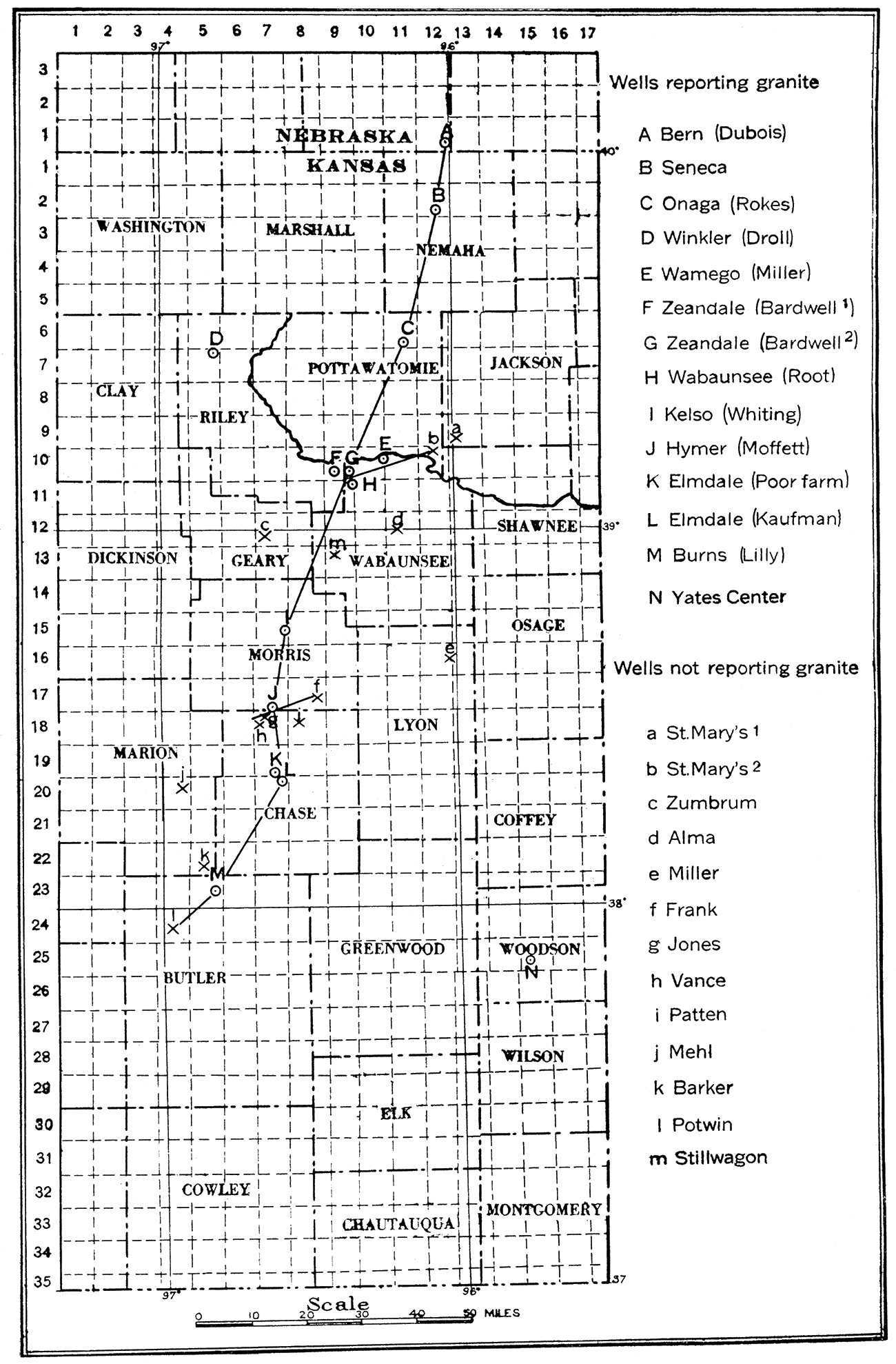
Plate XXI—Location map of central Kansas, showing wells which have encountered granite and associated wells which have not reached granite. The lines of sections A, B, C, Plate XXII, are shown.
Central Kansas
The wells which have encountered crystalline rocks in the central Kansas region are arranged in a line trending from north-northeast to south-southwest. This line extends from a point in Nebraska just beyond the northern boundary of Kansas to the southern portion of Kansas, as shown upon the accompanying map (Plate XXI). The distance of 'the northernmost well near Dubois, southern Nebraska, from the nearest Pre-Cambrian area which lies in the southeastern part of South Dakota, is about 230 miles (See Fig. 24). The central part of the line of wells reporting granite lies near Cottonwood Falls and Elmdale, Kan. The distance from wells here to the nearest Pre-Cambrian areas to the eastward in the St. Francis mountains is about 330 miles, and westward to the crystalline rocks of Colorado, about 500 miles. The southernmost locality at which crystalline rocks have been struck in Kansas is in northern Butler county near Burns. The distance from this locality to the nearest outcrops of Pre-Cambrian rocks in southern Oklahoma is about 230 or 240 miles. The distance from the northernmost of the wells in which the crystalline rocks have been struck to the southernmost is about 165 miles.
| A. Record of well near Bern, Pawnee county, Nebraska. Index letter refers to map, Plate XXI. |
||||
|---|---|---|---|---|
| Stratum | Thickness | Depth | ||
| feet | inches | feet | inches | |
| Soil | 8 | 0 | 8 | 0 |
| Limestone | 2 | 0 | 10 | 0 |
| Shale, black | 4 | 0 | 14 | 0 |
| Limestone and shale | 13 | 0 | 27 | 0 |
| Shale | 3 | 0 | 30 | 0 |
| Shale and limestone | 20 | 0 | 50 | 0 |
| Shale, black | 1 | 0 | 51 | 0 |
| Shale | 12 | 0 | 63 | 0 |
| Shale | 54 | 4 | 117 | 4 |
| Shale, black | 4 | 0 | 121 | 4 |
| Limestone | 21 | 8 | 143 | 0 |
| Limestone | 27 | 9 | 170 | 9 |
| Slate, black | 4 | 0 | 174 | 9 |
| Limestone | 1 | 6 | 176 | 3 |
| Shale, soft | 11 | 3 | 187 | 6 |
| Limestone | 5 | 6 | 193 | 0 |
| Shale, red | 24 | 4 | 217 | 4 |
| Shale | 5 | 8 | 223 | 0 |
| Shale, soft | 1 | 0 | 224 | 0 |
| Limestone | 8 | 0 | 232 | 0 |
| Shale, black | 32 | 6 | 264 | 6 |
| Shale | 12 | 6 | 277 | 0 |
| Limestone | 4 | 0 | 281 | 0 |
| Shale | 8 | 4 | 289 | 4 |
| Limestone | 20 | 0 | 309 | 4 |
| Limestone and shale | 8 | 4 | 317 | 8 |
| Shale | 7 | 4 | 325 | 0 |
| Limestone | 35 | 0 | 360 | 0 |
| Limestone and streaks of soft shale | 5 | 8 | 365 | 8 |
| Shale, black | 0 | 6 | 366 | 2 |
| Limestone | 1 | 6 | 367 | 8 |
| Shale, black | 26 | 0 | 393 | 8 |
| Limestone and shale in thin layers | 64 | 0 | 457 | 8 |
| Shale, black | 13 | 4 | 471 | 0 |
| Shale, changing to limestone, then to shale, soft | 11 | 6 | 482 | 6 |
| Sandstone, micaceous, with granular limestone | 10 | 6 | 493 | 0 |
| Sandstone, micaceous, coarse and granular | 23 | 0 | 516 | 0 |
| Sandstone, finer-grained | 16 | 0 | 532 | 0 |
| Sandstone, very fine-grained | 18 | 0 | 550 | 0 |
| Sandstone, fine-grained, firm, containing traces of chloride | 12 | 0 | 562 | 0 |
| From 482 feet to the bottom the rock is full of vertical seams or fissures. | ||||
Wells reporting crystalline rocks. The northernmost well included in this report is one noted by Haworth (Haworth, 1915, p. 17). This is the Bern or Dubois well drilled for the Chicago, Rock Island & Pacific railroad on Nemaha river, in the vicinity of Bern, Pawnee county, Nebraska (Sec. 25, T. 1 N., R. 12 E,). Record was furnished by M. A. Low. Elevation approximately 1,125 feet.
In view of the statements made by Haworth in his discussion of the crystalline rocks in Kansas (Haworth, 1915, p. 15-16) and the results of recent drilling in the general region, it is believed that the log of this well indicates clearly that crystalline rock was reached at a depth of approximately 550 feet, and although no samples of the cuttings are available for study, the verqal description of the rock corresponds almost exactly with the numerous samples which have been examined from the wells farther south.
The next well of interest is the Seneca well, near Seneca, Nemaha county, Kansas, about fifteen miles south of the Bern well (sec, 34, T. 2 S., R. 12 E.), Elevation approximately 1,150 feet.
| B. Record of well near Seneca, Nemaha county, Kansas. | ||
|---|---|---|
| Stratum | Thickness, feet |
Depth, feet |
| Soil | 8 | 8 |
| Shale, gray | 30 | 38 |
| Gravel, sandy | 8 | 46 |
| Shale, hard, white | 25 | 71 |
| Shale, hard, dark | 39 | 110 |
| Limestone, hard, white | 110 | 220 |
| Coal | ||
| Limestone, soft, white | 20 | 240 |
| Limestone, hard, white | 35 | 275 |
| Limestone, hard, gray | 25 | 300 |
| Limestone, hard, white | 60 | 360 |
| Shale, white | 25 | 385 |
| Limestone, gray | 3 | 388 |
| Slate, dark | 2 | 390 |
| Limestone, hard, white | 52 | 442 |
| Shale | 15 | 457 |
| Limestone, white | 30 | 487 |
| Limestone, gray | 17 | 504 |
| Shale, light | 15 | 519 |
| Limestone, hard, white | 62 | 581 |
| Sandstone, dark | 5 | 586 |
| Granite, hard, red | 43 | 629 |
| Granite, dark, red | 32 | 661 |
| Granite, hard, red | 24 | 685 |
| Granite, soft, red (salt water) | 18 | 703 |
| Granite, hard, light | 43 | 746 |
Hard red granite was reached at a depth of 586 feet in this' well, and the drilling was continued to a depth of 746 feet. Unfortunately no samples of the cuttings in the granite were preserved for study, and it is not possible to make a definite statement concerning the rock in the lower part of the Seneca well. Some question as to the reliability of the driller's record is indicated by Haworth (Haworth, 1915, p. 19), but it is impossible to verify the data concerning the granite, the well having been drilled in 1904 and all of the cuttings long since disappeared.
Almost due south, about twenty-five miles from Seneca, there is another well in which crystalline rock was reached. This, the Rokes well (C), drilled by the Empire Gas and Fuel Company, is near Onaga (Sec. 34, T. 6 S., R. 11 E.). Although a complete log of the well was not available, it was found that granite was struck at a depth of 960 feet. The well was shut down on January 18, 1917, at a depth of 1,810 feet.
A new well is recently reported to have reached granite at a locality considerably to the west of the line of wells already noted. This is the Droll well of the Gypsy Oil Company, situated near Winkler, about thirty-five miles due west of Onaga, Riley county, Kansas (Sec. 2, T. 7 S., R. 5 E.). This well was completed on June 30, 1917, and the complete log of it is given herewith through the courtesy of Mr. M. J. Munn, chief geologist of the Gypsy Oil Company, and Mr. J. L. Gartner, who supplied considerable information upon this and several other wells which reached the granite. Mr. Gartner sent in a sample of the granite from a depth of 2,416 feet in the Droll well.
| D. Record of the Droll well, Riley county, Kansas. | ||
|---|---|---|
| Stratum | Thickness, feet |
Depth, feet |
| Soil | 4 | 4 |
| Shale | 21 | 25 |
| Limestone | 10 | 35 |
| Limestone | 25 | 60 |
| Shale | 10 | 70 |
| Limestone | 35 | 105 |
| Shale | 250 | 355 |
| Limestone | 25 | 380 |
| Shale | 30 | 410 |
| Redrock | 10 | 420 |
| Shale | 30 | 450 |
| Redrock | 40 | 490 |
| Shale | 20 | 510 |
| Limestone | 10 | 520 |
| Redrock | 5 | 525 |
| Limestone | 40 | 565 |
| Shale | 35 | 600 |
| Limestone | 15 | 615 |
| Shale | 75 | 690 |
| Limestone | 10 | 700 |
| Shale | 25 | 725 |
| Limestone | 15 | 740 |
| Shale | 25 | 765 |
| Limestone, blue, soft | 30 | 795 |
| Shale, white, hard | 10 | 805 |
| Limestone, blue, soft, water, salty | 45 | 850 |
| Shale, white, medium | 20 | 870 |
| Limestone, blue, soft | 195 | 1,065 |
| Shale, blue, soft | 3 | 1,068 |
| Limestone, white, hard | 12 | 1,080 |
| Sandstone, white, medium | 15 | 1,095 |
| Limestone, white, hard | 85 | 1,170 |
| Shale, blue, soft | 4 | 1,174 |
| Limestone, white, medium | 66 | 1,240 |
| Shale, blue, soft | 5 | 1,245 |
| Limestone, white, hard | 50 | 1,295 |
| Shale, white, soft | 5 | 1,300 |
| Limestone, white, hard | 60 | 1,360 |
| Shale, blue, soft | 8 | 1,368 |
| Limestone, white, hard | 4 | 1,372 |
| Shale, blue, green | 44 | 1,416 |
| Redrock, soft | 19 | 1,435 |
| Limestone, white, hard | 15 | 1,450 |
| Shells, red, rock | 25 | 1,475 |
| Shale, blue, soft | 10 | 1,485 |
| Redrock, soft | 75 | 1,560 |
| Shale, blue, soft | 15 | 1,575 |
| Limestone, white, hard (Little gas at 1,630 ft.) |
235 | 1,810 |
| Shale, white, soft | 3 | 1,813 |
| Limestone, white, hard | 225 | 2,038 |
| Shale, white, soft | 72 | 2,110 |
| Limestone, white, hard | 165 | 2,275 |
| Shale, blue, soft | 25 | 2,300 |
| Limestone, white, hard | 67 | 2,367 |
| Redrock, soft | 18 | 2,385 |
| Granite, red, hard | 135 | 2,520 |
The next well to the south which is reported to have reached the crystalline rocks is the Miller well (E) (Sec. 12, T. 10 S., R. 10 E.) of the Carter Oil Company, which is on a line nearly due south of the Seneca and Onaga wells, just east of the town of Wamego, Pottawatomie county, in the valley of Kansas river. The log from this well is somewhat incomplete, but up to a depth of 2,215 feet the formations are indicated as chiefly slate and sand. The lowest record on the log shows sand at a depth of 2,215 feet. A later report stated that the drillers were fishing in granite at a depth of 2,400 feet. Further information has not been obtained. It is very probable that the top of the granite was encountered a short distance below the bottom of the log, The Wamego well is shown in cross-section B (Plate XXII).
Southwest of the Miller well about eight miles, and just south of the town of Wabaunsee, Wabaunsee county (Sec, 1, T. 11 S., R, 9 E.), is the Root well of the Empire Gas and Fuel Company. Granite is reported to have been encountered below a depth of 1,180 feet. Elevation at casing head, 1,069 feet. The log of the well is as follows:
| H. Record of well south of Wabaunsee, Wabaunsee county. | ||
|---|---|---|
| Stratum | Thickness, feet |
Depth, feet |
| Shale | 90 | 90 |
| Limestone | 20 | 110 |
| Shale, black | 5 | 115 |
| Shale, light | 10 | 125 |
| Shale, black | 40 | 165 |
| Sandstone | 30 | 195 |
| Sand (water) | 23 | 218 |
| Limestone | 92 | 310 |
| Shale | 10 | 320 |
| Limestone | 30 | 350 |
| Sandstone | 30 | 380 |
| Shale (little gas) | 15 | 395 |
| Limestone | 26 | 421 |
| Shale | 39 | 460 |
| Limestone | 24 | 484 |
| Shale | 20 | 504 |
| Limestone | 2 | 506 |
| Sandstone | 16 | 522 |
| Shale | 20 | 542 |
| Limestone | 38 | 580 |
| Shale | 6 | 580 |
| Limestone | 6 | 592 |
| Shale | 36 | 628 |
| Limestone | 4 | 632 |
| Redrock | 20 | 652 |
| Shale | 6 | 658 |
| Sandstone | 17 | 675 |
| Shale | 60 | 735 |
| Limestone | 70 | 805 |
| Shale | 65 | 870 |
| Limestone | 102 | 972 |
| Shale | 13 | 985 |
| Limestone | 6 | 991 |
| Shale and coal | 95 | 1,086 |
| Limestone | 29 | 1,115 |
| Shale | 5 | 1,120 |
| Shale and flint | 60 | 1,180 |
| Granite, red | 200 | 1,380 |
| Granite, gray | 80 | 1,460 |
| Granite, red | 20 | 1,480 |
| Granite, gray | 510 | 1,990 |
Several samples of the cuttings from this well were obtained, and are described in the section on petrography.
The next wells to be considered are the two Bardwell wells near Zeandale, Wabaunsee county (Sec. 26, T. 10 S., R. 9 E.). Inasmuch as the records from these two wells are almost identical, the log of Bardwell well No. 2 is given. Elevation approximately 1,050 to 1,075 feet. The drilling record [is as follows:]
| G. Record of Bardwell well No. 2, Zeandale, Wabaunsee county. | ||
|---|---|---|
| Stratum | Thickness, feet |
Depth, feet |
| Soil and clay | 10 | 10 |
| Clay, soft | 20 | 30 |
| Sand, fine | 10 | 40 |
| Clay, blue | 20 | 60 |
| Gravel. coarse | 6 | 66 |
| Clay, blue | 17 | 83 |
| Limestone | 2 | 85 |
| Shale, light, blue | 80 | 165 |
| Limestone | 4 | 169 |
| Shale, blue | 88 | 257 |
| Limestone | 26 | 283 |
| Shale, light | 12 | 295 |
| Shale, sandy | 10 | 305 |
| Shale | 15 | 320 |
| Limestone | 43 | 363 |
| Shale | 10 | 373 |
| Limestone | 5 | 378 |
| Shale | 12 | 390 |
| Limestone | 8 | 398 |
| Shale, black | 2 | 400 |
| Limestone | 25 | 425 |
| Shale | 50 | 475 |
| Limestone | 5 | 480 |
| Shale, light | 5 | 485 |
| Limestone | 24 | 509 |
| Shale | 1 | 510 |
| Limestone | 15 | 525 |
| Clay | 5 | 530 |
| Limestone | 4 | 534 |
| Shale, blue | 76 | 610 |
| Limestone | 5 | 615 |
| Shale | 5 | 620 |
| Redrock | 2 | 622 |
| Shale | 3 | 625 |
| Limestone | 8 | 633 |
| Shale, light | 25 | 658 |
| Limestone | 7 | 665 |
| Shale | 4 | 669 |
| Limestone | 1 | 670 |
| Shale | 2 | 672 |
| Limestone | 1 | 673 |
| Shale | 1 | 674 |
| Limestone | 19 | 693 |
| Shale, blue | 3 | 696 |
| Limestone | 1 | 697 |
| Shale | 3 | 700 |
| Limestone | 5 | 705 |
| Shale | 5 | 710 |
| Limestone | 18 | 728 |
| Shale | 3 | 731 |
| Limestone | 4 | 735 |
| Shale, light | 8 | 743 |
| Limestone | 40 | 783 |
| Shale | 1 | 784 |
| Limestone | 10 | 794 |
| Shale | 2 | 796 |
| Limestone | 26 | 822 |
| Shale, light | 4 | 826 |
| Limestone | 2 | 828 |
| Shale | 2 | 830 |
| Limestone | 35 | 865 |
| Shale | 4 | 869 |
| Limestone | 4 | 873 |
| Shale | 2 | 875 |
| Limestone | 8 | 883 |
| Shale | 2 | 885 |
| Limestone | 15 | 900 |
| Shale | 4 | 904 |
| Limestone | 49 | 953 |
| Shale | 5 | 958 |
| Granite, gray | 17 | 975 |
| Granite, red | 15 | 990 |
| Shale | 1 | 991 |
| Granite, gray | 102 | 1,093 |
The one-foot bed of shale between 990 and 991 feet is to be noted. This without doubt seems to be the driller's error, inasmuch as no way is known in which a true shale could occur in the midst of a granite mass such as this undoubtedly is. The so-called shale is either chloritic material which is present in veins or fissures in the granite, or else it is shale which fell into the drill hole and was brought up in the bailer. Several fairly large pieces of granite, as well as numerous samples of the finer cuttings, were obtained from this well and are available for study.
The next well lies about thirty miles to the south-southwest and is northwest of Council Grove, near Kelso. This is the Whiting well No. 1, drilled by the Cosden Oil and Gas Company (Echo Oil Company), in Morris county (Sec. 24, T. 15 S., R. 17 E.). Elevation at casing head, 1,384 feet. The log of this well [is as follows:]
| I. Record of Whiting well No. 1, near Kelso, Morris county. | ||
|---|---|---|
| Stratum | Thickness, feet |
Depth, feet |
| Limestone | 48 | 48 |
| Shale | 5 | 53 |
| Limestone | 20 | 73 |
| Shale | 9 | 82 |
| Limestone | 8 | 90 |
| Shale | 20 | 110 |
| Sandstone | 10 | 120 |
| Shale | 37 | 157 |
| Limestone | 5 | 162 |
| Shale | 20 | 182 |
| Redrock | 15 | 197 |
| Shale | 5 | 202 |
| Limestone | 10 | 212 |
| Shale | 33 | 245 |
| Limestone | 5 | 250 |
| Shale | 40 | 290 |
| Limestone | 15 | 305 |
| Shale | 60 | 365 |
| Limestone | 5 | 370 |
| Shale | 35 | 405 |
| Limestone | 5 | 410 |
| Shale | 15 | 425 |
| Limestone | 25 | 450 |
| Shale | 80 | 530 |
| Limestone | 5 | 535 |
| Shale | 13 | 548 |
| Limestone | 5 | 553 |
| Shale | 47 | 600 |
| Limestone | 10 | 610 |
| Shale | 10 | 620 |
| Limestone | 7 | 627 |
| Shale | 13 | 640 |
| Limestone | 20 | 660 |
| Shale | 62 | 722 |
| Limestone | 8 | 730 |
| Shale | 4 | 734 |
| Limestone | 3 | 737 |
| Shale | 13 | 750 |
| Limestone | 8 | 758 |
| Shale | 32 | 790 |
| Limestone | 12 | 802 |
| Shale | 33 | 835 |
| Limestone | 5 | 840 |
| Shale | 5 | 845 |
| Limestone | 5 | 850 |
| Shale | 5 | 855 |
| Limestone (little salt water) | 10 | 865 |
| Shale | 65 | 930 |
| Limestone | 20 | 950 |
| Shale | 3 | 953 |
| Limestone | 7 | 960 |
| Shale | 20 | 980 |
| Limestone | 5 | 985 |
| Sand (salt water | 10 | 995 |
| Shale | 20 | 1,015 |
| Limestone | 10 | 1,025 |
| Sand (salt water) | 5 | 1,030 |
| Limestone | 20 | 1,050 |
| Shale | 5 | 1,055 |
| Limestone | 40 | 1,095 |
| Shale | 20 | 1,115 |
| Limestone | 80 | 1,195 |
| Shale | 40 | 1,235 |
| Sand (water) | 20 | 1,255 |
| Shale | 30 | 1,285 |
| Limestone | 5 | 1,290 |
| Shale | 5 | 1,295 |
| Redrock | 5 | 1,300 |
| Sandstone | 25 | 1,325 |
| Shale | 45 | 1,370 |
| Limestone | 40 | 1,420 |
| Shale | 5 | 1,425 |
| Limestone | 30 | 1,455 |
| Shale | 18 | 1,473 |
| Limestone | 29 | 1,502 |
| Shale | 13 | 1,515 |
| Limestone | 125 | 1,640 |
| Shale | 5 | 1,645 |
| Limestone | 50 | 1,695 |
| Shale | 10 | 1,705 |
| Sandstone | 5 | 1,710 |
| Shale | 60 | 1,770 |
| Limestone | 22 | 1,792 |
| Shale | 11 | 1,803 |
| Limestone | 5 | 1,808 |
| Shale | 7 | 1,815 |
| Limestone | 17 | 1,832 |
| Shale | 27 | 1,859 |
| Limestone | 5 | 1,864 |
| Shale | 18 | 1,882 |
| Limestone | 5 | 1,887 |
| Sand (salt water) | 18 | 1,905 |
| Limestone, flinty | 20 | 1,925 |
| Sandstone | 10 | 1,935 |
| Limestone | 25 | 1,960 |
| Limestone, sandy | 70 | 2,030 |
| Shale | 17 | 2,047 |
| Sand (salt water) | 53 | 2,100 |
| Shale | 5 | 2,105 |
| Sandstone | 55 | 2,160 |
| Limestone | 58 | 2,218 |
| Sand (water) | 52 | 2,270 |
| Redrock | 10 | 2,280 |
| Limestone | 220 | 2,500 |
| Sand | 12 | 2,512 |
| Granite, gray | 39 | 2,551 |
It is noted that the granite was reached at a depth of about 2,512 feet. This is very different from the depth at Zeandale. Unfortunately no specimens of the drill cuttings from this granite have been received.
About fifteen miles south of the Whiting well is the Moffett well, northeast of Hymer, in Morris county (Sec. 34, T. 17 S., R. 7 E.), drilled by the Empire Gas and Fuel Company. Elevation at casing head, 1,560 feet. The log of the Moffett well, which was kindly furnished by Mr. J. L. Gartner, shows a probable error in the driller's record. It will be noticed that "granite, gray, hard," is reported from a depth of 2,092 to 2,095 feet, with "lime, white," then "sand" recorded below. Undoubtedly the rock identified as granite in this place has been incorrectly determined. It is probable that the "sandy lime, gray, very hard," from 2,480 to 2,505 feet, is the lowest of the true sedimentary series, and that below the latter depth are found truly crystalline rocks. Therefore, the depth at which granite was reached in this well is about 2,505 feet, and approximately 100 feet of granite was penetrated. It is, of course, possible that the quartzite and sand reported in the log are Pre-Cambrian sedimentary rocks which are considerably metamorphosed, and that true granite was not reached in the hole. If this is the case the well would correspond with some of the deep wells in Iowa and other states to the north, where a considerable thickness of Pre-Cambrian quartzite overlies the crystalline rocks.
| J. Record of the Moffett well, near Hymer, Morris county. | ||
|---|---|---|
| Stratum | Thickness, feet |
Depth, feet |
| Earth and flint | 5 | 5 |
| Limestone, gray, hard | 23 | 28 |
| Shale, gray, medium | 12 | 40 |
| Shale, red, soft | 15 | 55 |
| Shale, gray, medium | 15 | 70 |
| Limestone, gray, medium (water) | 14 | 84 |
| Shale, gray, medium | 22 | 106 |
| Limestone, gray, hard (water) | 17 | 123 |
| Shale, gray, medium | 22 | 144 |
| Limestone, gray, hard | 6 | 151 |
| Shale, gray, medium | 3 | 154 |
| Limestone, gray, soft (water) | 6 | 160 |
| Shale, brown, soft | 62 | 222 |
| Limestone, brown, medium | 8 | 230 |
| Shale, white, soft | 10 | 240 |
| Limestone, gray, medium | 15 | 255 |
| Shale, brown, soft | 15 | 270 |
| Red rock, soft | 15 | 285 |
| Limestone, gray, hard | 15 | 300 |
| Shale, gray, soft | 15 | 315 |
| Limestone, gray, hard | 12 | 327 |
| Shale, gray, soft | 23 | 350 |
| Limestone, gray, hard | 22 | 373 |
| Shale, gray, soft | 8 | 380 |
| Limestone, gray, hard | 27 | 407 |
| Shale, black, soft | 92 | 485 |
| Shale, gray, soft | 15 | 500 |
| Shale, white, soft | 30 | 530 |
| Shale, black, soft | 30 | 560 |
| Shale, gray, soft | 20 | 580 |
| Shale, black, soft | 10 | 590 |
| Shale, black, soft | 25 | 616 |
| Sandstone, gray, medium | 5 | 620 |
| Shale, white, soft | 35 | 655 |
| Limestone, gray, medium | 3 | 658 |
| Shale, white, soft | 37 | 695 |
| Sandstone, white, medium | 30 | 725 |
| Limestone, white, hard | 13 | 738 |
| Shale, black, soft | 28 | 766 |
| Shale, gray, soft | 12 | 778 |
| Limestone, dark, hard | 25 | 803 |
| Shale, black, soft | 32 | 835 |
| Limestone, gray, hard | 5 | 840 |
| Shale, white, medium | 45 | 885 |
| Shale, black, soft | 20 | 905 |
| Limestone, gray, hard | 10 | 915 |
| Shale, black, soft | 35 | 980 |
| Limestone, gray, hard | 35 | 1,015 |
| Shale, black, soft | 5 | 1,020 |
| Sandstone, gray, soft | 8 | 1,028 |
| Shale, black, soft | 22 | 1,050 |
| Limestone, gray, hard | 40 | 1,090 |
| Shale, green, soft | 5 | 1,095 |
| Shale, brown, soft | 5 | 1,100 |
| Limestone, gray, hard | 10 | 1,110 |
| Shale, gray, soft | 12 | 1,122 |
| Limestone, gray, hard | 18 | 1,140 |
| Shale, black, soft | 8 | 1,148 |
| Limestone, gray, hard | 12 | 1,160 |
| Shale, black, soft | 10 | 1,170 |
| Limestone, gray, hard | 30 | 1,200 |
| Shale, black, soft | 6 | 1,206 |
| Limestone, white, hard | 8 | 1,214 |
| Shale, black, soft | 31 | 1,245 |
| Limestone, white, hard | 26 | 1,271 |
| Limestone, white, hard | 26 | 1,297 |
| Shale, brown, medium | 23 | 1,230 |
| Limestone, gray, hard | 15 | 1,335 |
| Shale, brown, soft | 90 | 1,425 |
| Limestone, gray, hard | 5 | 1,430 |
| Shale and limestone, brown and gray | 20 | 1,450 |
| Shale, brown, soft | 65 | 1,515 |
| Limestone, white, hard | 80 | 1,595 |
| Shale, black, soft | 5 | 1,600 |
| Limestone, gray, hard | 135 | 1,735 |
| Shale, black, soft | 12 | 1,747 |
| Limestone, gray, hard | 113 | 1,860 |
| Sandstone, gray, hard | 30 | 1,890 |
| Shale, black, soft | 10 | 1,900 |
| Limestone, sandy, gray, medium | 15 | 1,915 |
| Shale, gray, cavy | 30 | 1,945 |
| Limestone, gray, hard | 10 | 1,955 |
| Shale, varied, soft | 2 | 1,957 |
| Limestone, gray, medium | 5 | 1,962 |
| Shale, black, soft | 10 | 1,972 |
| Limestone, white, medium | 20 | 1,992 |
| Shale, brown, soft | 6 | 1,998 |
| Coal, black, soft | 4 | 2,002 |
| Shale, brown, soft | 14 | 2,016 |
| Limestone, white, hard | 19 | 2,035 |
| Shale, brown, cavy | 20 | 2,055 |
| Shale, gray, soft | 15 | 2,060 |
| Shale, black, soft | 20 | 2,080 |
| Sandstone, gray, medium | 10 | 2,090 |
| Shale, grav, soft | 2 | 2,092 |
| Granite (?), gray, hard | 3 | 2,095 |
| Limestone and flint, hard | 10 | 2,105 |
| Limestone, white, hard | 15 | 2,120 |
| Limestone, white hard | 18 | 2,138 |
| Limestone, white, hard | 22 | 2,160 |
| Sandstone, white, hard | 15 | 2,175 |
| Sandstone, grey, hard | 15 | 2,190 |
| Sandstone, white, hard | 10 | 2,200 |
| Sandstone, gray, very hard | 3 | 2,203 |
| Sandstone, and pyrite | 7 | 2,210 |
| Shale, blue, sticky | 13 | 2,220 |
| Sandstone, white, hard | 3 | 2,255 |
| Sandstone, gray, hard | 35 | 2,290 |
| Limestone, sandy, gray, very hard | 180 | 2,470 |
| Limestone, sandy, very hard | 10 | 2.480 |
| Limestone, sandy, gray and very hard | 25 | 2,505 |
| Sandstone, gray, very hard | 20 | 2,525 |
| Quartzite (granite), gray, very hard | 83 | 2,608 |
About twenty-five miles in a direction west of south from Council Grove are two more deep wells which have encountered the granite. These are in the vicinity of Elmdale, on Cottonwood river, in the central part of Chase county, the one noted by Haworth (1915, p. 27-29). being located on the Chase county poor farm (SW of SW, Sec. 34, T. 19 S., R. 7 E.) two miles south of Elmdale, and the other, known as the Kaufman well, three miles southeast of Elmdale (NW of NE, Sec. 2, T. 20 S., R. 7 E.). Elevation at casing head, 1,203 feet. The log of the Poor Farm well, reported by A. L. Derby, driller, is as follows:
| K. Record of Chase County Poor Farm well No. 1, near Elmdale, Chase county. | ||
|---|---|---|
| Stratum | Thickness, feet |
Depth, feet |
| Soil | 2 | 2 |
| Clay | 33 | 35 |
| Gravel | 10 | 45 |
| Limestone | 3 | 48 |
| Shale | 17 | 65 |
| Limestone | 5 | 70 |
| Shale | 60 | 130 |
| Sand gas | 10 | 140 |
| Shale | 50 | 190 |
| Sandstone | 20 | 210 |
| Shale | 30 | 240 |
| Limestone | 10 | 250 |
| Shale | 30 | 280 |
| Limestone | 20 | 300 |
| Shale, white | 5 | 305 |
| Limestone | 10 | 315 |
| Shale, black | 15 | 330 |
| Limestone | 10 | 340 |
| Sandstone | 5 | 345 |
| Limestone | 5 | 350 |
| Shale | 5 | 355 |
| Limestone | 15 | 370 |
| Shale | 70 | 440 |
| Limestone | 10 | 450 |
| Shale | 40 | 490 |
| Limestone | 5 | 495 |
| Shale | 15 | 510 |
| Limestone | 5 | 515 |
| Shale | 10 | 525 |
| Sand gas | 10 | 535 |
| Shale | 30 | 565 |
| Limestone | 5 | 570 |
| Shale | 5 | 575 |
| Limestone | 25 | 600 |
| Shale | 5 | 605 |
| Sand gas | 10 | 615 |
| Shale | 35 | 650 |
| Limestone | 10 | 660 |
| Shale | 15 | 675 |
| Limestone | 10 | 685 |
| Limestone | 5 | 690 |
| Shale | 30 | 720 |
| Limestone | 15 | 735 |
| Shale | 10 | 745 |
| Limestone | 20 | 765 |
| Shale | 10 | 775 |
| Limestone | 10 | 785 |
| Shale, black | 20 | 805 |
| Shale | 35 | 840 |
| Limestone | 45 | 885 |
| Shale | 10 | 895 |
| Limestone | 5 | 900 |
| Shale | 65 | 965 |
| Sandstone | 10 | 975 |
| Limestone | 5 | 980 |
| Shale | 50 | 1,030 |
| Limestone | 5 | 1,035 |
| Shale | 25 | 1,060 |
| Limestone | 5 | 1,065 |
| Shale | 80 | 1,145 |
| Limestone | 20 | 1,165 |
| Sandstone (gas) | 5 | 1,170 |
| Limestone | 20 | 1,190 |
| Shale | 4 | 1,194 |
| Limestone | 30 | 1,224 |
| Shale | 4 | 1,228 |
| Limestone | 7 | 1,235 |
| Shale | 20 | 1,255 |
| Limestone | 70 | 1,325 |
| Shale | 5 | 1,330 |
| Limestone | 40 | 1,370 |
| Shale | 10 | 1,380 |
| Limestone | 15 | 1,395 |
| Shale | 5 | 1,400 |
| Limestone | 5 | 1,405 |
| Shale | 15 | 1,420 |
| Limestone | 30 | 1,450 |
| Shale | 5 | 1,455 |
| Limestone | 35 | 1,490 |
| Shale | 5 | 1,495 |
| Limestone | 5 | 1,500 |
| Shale | 95 | 1,595 |
| Slate, black | 10 | 1,605 |
| Limestone | 15 | 1,620 |
| Shale | 20 | 1,640 |
| Limestone | 20 | 1,660 |
| Shale, black | 5 | 1,665 |
| Shale, blue | 30 | 1,695 |
| Shale, dark | 5 | 1,700 |
| Shale | 7 | 1,707 |
| Sand, pebbly | 43 | 1,750 |
| Sand, white | 30 | 1,780 |
| Sand, pebbly | 25 | 1,805 |
| Sand, red (granite?) | 142 | 1,947 |
| Sand, black (granite?) | 7 | 1,954 |
| Sand, red (granite?) | 16 | 1,970 |
| Sand, black (granite?) | 10 | 1,980 |
| Granite | 521 | 2,501 |
| a. Angular granite cuttings from depths of 2,243, 2,345, 2,385 and 2,501 feet below the surface. |
||
Samples of the cuttings from the lower portion of this well from depths of 2,243 feet down to 2,501 feet are discussed in the section on petrography.
The other Elmdale well is on the Kaufman farm (NW, NE, Sec, 2, T. 20 S., R. 7 E,). Elevation at casing head, 1,388,5 feet. The log of the well is as follows:
| L. Record of Kaufman well, near Elmdale, Chase county, Kansas. | ||
|---|---|---|
| Stratum | Thickness, feet |
Depth, feet |
| Soil, dark, soft | 10 | 10 |
| Limestone, hard, white | 5 | 15 |
| Shale, soft, blue | 5 | 20 |
| Limestone, soft, light | 5 | 25 |
| Shale, soft, gray and red | 5 | 30 |
| Limestone, soft, pink | 10 | 40 |
| Limestone, soft, white | 7 | 47 |
| Limestone, medium, white | 23 | 70 |
| Shale, soft, black | 30 | 100 |
| Shale, soft, gray | 50 | 150 |
| Limestone, hard, white | 10 | 160 |
| Shale, soft, white | 25 | 185 |
| Limestone, hard, gray | 3 | 188 |
| Shale, soft, black | 8 | 196 |
| Shale, hard, white | 40 | 236 |
| Limestone, hard, black | 4 | 240 |
| Shale, soft, black | 18 | 258 |
| Limestone, gray, medium | 5 | 263 |
| Shale, medium, white | 13 | 276 |
| Shale, soft, brown | 20 | 296 |
| Limestone, medium: gray | 10 | 306 |
| Shale, soft, brown | 20 | 326 |
| Sandstone, soft brown (gas) | 30 | 356 |
| Shale, soft, brown | 17 | 373 |
| Sandstone, soft, brown and white (water) | 23 | 396 |
| Limestone, medium, brown | 5 | 401 |
| Shale, soft, brown | 15 | 416 |
| Shale, hard, white | 8 | 424 |
| Limestone, very hard, gray | 8 | 432 |
| Shale, soft, brown | 39 | 471 |
| Limestone, hard, gray | 20 | 491 |
| Shale, soft, brown | 5 | 496 |
| Limestone, hard, gray | 5 | 501 |
| Shale, soft, brown | 14 | 515 |
| Limestone, medium, gray | 28 | 543 |
| Shale, medium, white | 8 | 551 |
| Sand, soft, brown | 7 | 558 |
| Shale, medium, gray | 38 | 596 |
| Sandstone, soft, gray (water) | 7 | 603 |
| Shale, soft, brown | 38 | 641 |
| Sand, medium, brown | 11 | 652 |
| Shale, soft, brown | 34 | 686 |
| Sandstone, medium, gray, (water) | 35 | 721 |
| Sand, hard, white | 5 | 726 |
| Sand, hard, white | 5 | 731 |
| Sand, hard, white | 5 | 736 |
| Limestone, hard, gray | 40 | 776 |
| Shale, soft, brown (water) | 20 | 796 |
| Sand, medium, gray | 15 | 811 |
| Limestone, hard, black | 15 | 826 |
| Shale, hard, black | 15 | 841 |
| Limestone, hard, gray | 10 | 851 |
| Shale, soft, black | 29 | 880 |
| Limestone, medium, white | 3 | 883 |
| Shale, soft, brown | 24 | 907 |
| Limestone, hard, white | 6 | 913 |
| Limestone. soft, brown | 4 | 917 |
| Shale, soft, brown | 9 | 926 |
| Limestone, hard, brown | 22 | 948 |
| Shale, soft, black | 17 | 965 |
| Limestone, hard, brown | 24 | 989 |
| Shale, soft, white | 32 | 1,021 |
| Limestone, hard, mixed | 4 | 1,025 |
| Shale, soft, white | 4 | 1,029 |
| Limestone, hard, gray | 30 | 1,059 |
| Limestone, hard, brown | 15 | 1,074 |
| Limestone, hard, varied | 5 | 1,079 |
| Limestone, hard, white | 10 | 1,089 |
| Limestone and sandstone | 20 | 1,109 |
| Shale, soft, brown | 40 | 1,149 |
| Sand, soft, brown (water) | 30 | 1,179 |
| Shale, broken, brown | 10 | 1,189 |
| Limestone and shale, hard gray | 5 | 1,194 |
| Shale, soft, white | 15 | 1,209 |
| Sandstone, soft, light | 15 | 1,224 |
| Shale, soft, brown | 5 | 1,229 |
| Limestone, hard, white | 15 | 1,244 |
| Shale, soft, gray | 35 | 1,279 |
| Limestone, hard, white | 5 | 1,284 |
| Shale, soft, white | 64 | 1,348 |
| Limestone, hard, white | 34 | 1,382 |
| Shale, soft, black | 2 | 1,384 |
| Limestone, hard, white | 38 | 1,422 |
| Limestone, soft, brown | 20 | 1,442 |
| Shale, soft, black | 3 | 1,445 |
| Sandstone, gray, soft | 2 | 1,447 |
| Limestone, hard, white | 5 | 1,452 |
| Limestone, hard, white | 50 | 1,502 |
| Limestone, hard, white | 5 | 1,507 |
| Sandstone, hard, white | 5 | 1,512 |
| Limestone, hard, brown | 35 | 1,547 |
| Limestone, hard, gray | 35 | 1,582 |
| Shale, soft, white | 5 | 1,587 |
| Limestone, hard, white | 15 | 1,602 |
| Shale, soft, black | 10 | 1,612 |
| ---- | 50 | 1,662 |
| ---- | 26 | 1,688 |
| ---- | 74 | 1,762 |
| Limestone, hard, white | 3 | 1,765 |
| Sandstone, soft, light | 5 | 1,770 |
| Shale, soft, broken | 5 | 1,775 |
| Shale, white, broken | 10 | 1,785 |
| Shale, medium, gray | 7 | 1,792 |
| Limestone, hard, white | 4 | 1,796 |
| Limestone, soft, gray (8 in. casing set) | 11 | 1,807 |
| Shale, soft, gray | 20 | 1,827 |
| Shale, soft, black | 20 | 1,847 |
| Shale, soft, gray | 10 | 1,857 |
| Shale, soft, blue (showing of oil) | 33 | 1,890 |
| Granite, gray and red | 1,165 | 3,055 |
The great thickness of granite drilled through in the Kaufman well is of considerable interest. Samples of the cuttings at numerous intervals were submitted for study and are described in the section on petrography.
The southernmost of the wells in which crystalline rocks have been encountered lies in the north part of Butler county, just south of the county line (Sec. 14, T. 23 S., R. 5 E.). This is the Lilly well No. 1 of the Roxana Petroleum Company. Elevation at casing head, 1,480 feet. The log is as follows:
| M. Record of Lilly well No. 1, in northern Butler county, Kansas. | ||
|---|---|---|
| Stratum | Thickness, feet |
Depth, feet |
| Limestone | 45 | 45 |
| Sandstone | 5 | 50 |
| Shale | 10 | 60 |
| Limestone | 30 | 90 |
| Shale | 61 | 151 |
| Redrock | 5 | 156 |
| Limestone | 15 | 171 |
| Shale | 39 | 210 |
| Limestone, fossils | 6 | 216 |
| Shale, clayey | 9 | 225 |
| Limestone (water) | 5 | 230 |
| Shale | 6 | 236 |
| Limestone | 10 | 246 |
| Shale, blue, clayey | 7 | 253 |
| Shale | 39 | 292 |
| Shale, red, clayey | 12 | 304 |
| Limestone | 20 | 324 |
| Shale | 18 | 342 |
| Shale, blue, clayey | 20 | 362 |
| Limestone, fossils | 3 | 365 |
| Shale | 12 | 377 |
| Limestone | 13 | 390 |
| Shale, blue, clayey | 160 | 550 |
| Limestone | 15 | 565 |
| Shale, blue, clayey | 50 | 615 |
| Sandstone (water) | 7 | 622 |
| Shale | 108 | 730 |
| Limestone | 5 | 735 |
| Shale | 70 | 805 |
| Limestone | 15 | 820 |
| Shale | 150 | 970 |
| Sandstone (water) | 15 | 985 |
| Limestone | 5 | 990 |
| Shale | 20 | 1,010 |
| Limestone | 15 | 1,025 |
| Shale | 38 | 1,063 |
| Limestone | 2 | 1,065 |
| Shale | 30 | 1,095 |
| Limestone | 5 | 1,100 |
| Shale | 6 | 1,106 |
| Limestone | 20 | 1,126 |
| Shale | 44 | 1,170 |
| Limestone | 20 | 1,190 |
| Shale | 5 | 1,195 |
| Limestone | 75 | 1,270 |
| Shale | 15 | 1,285 |
| Limestone | 65 | 1,350 |
| Sandstone (water) | 20 | 1,370 |
| Shale | 60 | 1,430 |
| Sandstone | 10 | 1,440 |
| Limestone (water) | 5 | 1,445 |
| Sandstone, broken | 15 | 1,460 |
| Shale | 50 | 1,510 |
| Limestone | 10 | 1,520 |
| Shale | 10 | 1,530 |
| Sandstone (water) | 10 | 1,540 |
| Limestone | 20 | 1,560 |
| Shale | 45 | 1,605 |
| Limestone | 48 | 1,653 |
| Shale | 4 | 1,657 |
| Limestone | 90 | 1,747 |
| Shale | 103 | 1,850 |
| Limestone | 30 | 1,880 |
| Shale, sandy | 13 | 1,893 |
| Limestone | 22 | 1,915 |
| Shale | 15 | 1,930 |
| Limestone | 70 | 2,000 |
| Shale | 12 | 2,012 |
| Limestone | 10 | 2,022 |
| Shale | 22 | 2,044 |
| Sandstone (water) | 20 | 2,064 |
| Limestone | 26 | 2,090 |
| Shale, red | 10 | 2,100 |
| Shale | 15 | 2,115 |
| Limestone | 5 | 2,120 |
| Shale | 40 | 2,160 |
| Sandstone (water) | 20 | 2,180 |
| Limestone | 40 | 2,220 |
| Shale | 10 | 2,230 |
| Sandstone (show of oil and water) | 30 | 2,260 |
| Limestone, broken | 37 | 2,297 |
| Shale | 10 | 2,307 |
| Limestone | 5 | 2,312 |
| Sandstone, red (water) | 14 | 2,326 |
| Shale | 5 | 2,331 |
| Granite, red | 169 | 2,500 |
The depth to the granite in the Lilly well is great and shows a rather steep downward inclination of the top of the granite from the wells near Elmdale. This slope is shown on the north-south geologic cross-section which accompanies this report.
| Summary of wells in central Kansas which have encountered granite | ||||||||||
|---|---|---|---|---|---|---|---|---|---|---|
| Index Letter |
Location | County | Nearest town |
Farm | Drilled by |
Formation at surface |
Elevation feet |
Depth to granite, feet |
Depth of well, feet |
Amount of granite penetrated, feet |
| B | 34-2-12 | Nemaha | Seneca | 1,150 | 586 | 746 | 160 | |||
| C | 34-6-11 | Pottawatomie | Onaga | Rokes | Empire Gas & Fuel Co. | Elmdale shale | 960 | 1,810 | 850 | |
| D | 2-7-5 | Riley | Winkler | Droll | Gypsy Oil Co. | 2,385 | 2,520 | 135 | ||
| E | 12-10-10 | Wabaunsee | Wamego | Miller | Carter Oil Co. | 2,300+ | 2,400+ | (?) | ||
| F | 28-10-9 | Riley | Zeandale | Bardwell 1 | Eskridge shale | 1,050 | 928 | 1,020 | 92 | |
| G | 26-10-9 | Wabaunsee | Zeandale | Bardwell 2 | Elmdale shale | 1,075 | 958 | 1,093 | 135 | |
| H | 1-11-9 | Wabaunsee | Wabaunsee | Root | Empire Gas & Fuel Co. | Eskridge shale | 1,069 | 1,180 | 1,990 | 810 |
| I | 24-15-7 | Morris | Kelso | Whiting | Echo Oil Co. | Matfield shale | 1,384 | 2,512 | 2,551 | 39 |
| J | 34-17-7 | Morris | Hymer | Moffett | Empire Gas & Fuel Co. | Florence flint | 1,560 | 2,506 | 2,608 | 102 |
| K | 34-19-7 | Chase | Elmdale | Poor Farm | DeLaat & Shepard | Elmdale shale | 1,203 | 1,805 | 2,525 | 720 |
| L | 2-20-7 | Chase | Elmdale | Kaufman | Empire Gas & Fuel Co. | Garrison shale and limestone | 1,388 | 1,890 | 3,055 | 1,165 |
| M | 14-23-5 | Butler | Burns | Lilly | Roxana Petroleum Co. | Fort Riley limestone | 1,480 | 2,331 | 2,500 | 169 |
| N | 17-25-15 | Woodson | Yates Center | Aurora Oil & Gas Co. | Lawrence shale | 2,555 | 2,591 | 36 | ||
Wells Not Reporting Crystalline Rocks. To determine the topography of the old crystalline land surface buried beneath the Pennsylvanian rocks of central Kansas it is necessary to study the records of other wells in the vicinity of those already noted. The following notes are a compilation of all of the available data which bear on the subject.
It is unfortunate that for many of the wells which have been drilled near those encountering crystalline rocks no logs are available. It is very difficult, therefore, to determine the slope of the sides of the old crystalline ridge, or to locate its highest points.
(a) In Pottawatomie county, on St. Mary's College land (T. 9 S., R. 12 E.), a well was drilled to a depth of 1,892 feet. A 23-foot gas sand was reached at 435 feet, and a showing of oil obtained in sand at 1,650 feet. (b) One-half mile north of St. Mary's College (T. 10 S., R. 12 E.), a well was drilled to a depth of 1,700 feet. It encountered the normal succession of alternating limestone, shale and sandstone, which comprise the Pennsylvanian formations in Kansas.
(c) In Geary county (Sec. 28, T. 12 S., R. 7 E.), a well was drilled to a depth of 1,895 feet through a sequence of sedimentary rocks. A salt sand was found from a depth of 1,765 feet to the bottom of the hole, but no crystalline rocks were reached. (m) The Stillwagon well (Sec. 9, T. 13 S., R. 8 E.) was drilled to a depth of 2,725 feet, and encountered the normal series of limestones and shales.
(d) In Wabaunsee county (SE, Sec. 17, T. 12 S., R. 11 E.), there is a well 1,880 feet deep in which thin coal seams were encountered at 1,500 feet and at 1,640 feet, a showing of oil at 1,790 feet, and sandstone from 1,800 feet to the bottom of the hole.
(e) In Lyon county is a well (SW, SW, Sec. 13, T. 16 S., R. 12 E.) which reached the Mississippian limestone at 1,929 feet and was continued to a depth of 2,010 feet. No crystalline rocks were struck. A well (Sec, 34, T. 21 S., R. 10 E.) drilled to a depth of 2,355 feet ended in a water sand 15 feet thick.
(f) In Morris county, a well (SW, NE, Sec. 23, T. 17 S., R. 8 E.) drilled to a depth of 2,508 feet did not strike granite. At 1,805 feet one million feet of gas was encountered and at 1,980 feet a 15-foot sand, shale and sandstone continuing to the bottom of the hole.
(g) In Chase county (SE, SE, Sec. 5, T. 18 S., R. 7 E.), a well drilled to a depth of 1,409 feet shows shale from 1,340 to 1,370 feet, and sand below to the bottom of the hole. A showing of oil and gas was encountered in the last nine feet of sand. (h) Another well (Sec. 7, T. 18 S., R. 7 E,) was drilled to a depth of 1,408 feet, with shale and the Layton sand from 1,207 feet to 1,374 feet. (i) A well in Sec. 8, T. 18 S., R. 8 E., was drilled to a depth of 2,470 feet, through alternating shale and limestone, the hole ending in sandstone and salt water.
(j) In Marion county (Sec. 11, T. 20 S., R. 4 E.), a well was drilled to a depth of 2,692 feet through alternating shale, limestone and sandstone, no crystalline rocks being encountered. (k) A well in Sec. 34, T. 22 S., R. 5 E., drilled to a depth of 3,112 feet, passed through alternating limestone and sandstone, in its lower part.
(l) In Butler county, near the Potwin field (SW of SW, Sec. 21, T. 24 S., R. 4 E.), a well, 2,665 feet at the time log was obtained, was still drilling in shale and limestone. There is a seam of coal at 1,740 to 1,750 feet, and water sand at the bottom of the hole.
Other wells in the general region which have not reached granite are: Wetmore, Nemaha county, 2,230 feet; McFarland, Wabaunsee county, 2,006 feet [for log see below, report of Wabaunsee county]; Emporia, Lyon county, 1,951 feet.
Although nearly fifty miles removed from the nearest "granite well" at Dubois, Pawnee county, Nebraska, the deep well at Nebraska City, Otoe county, Nebraska, should be specially noted. This well, of which careful record was kept, was drilled to a depth of 3,010 feet, but did not encounter granite or other crystalline rock.
The Crystalline Rock Surface
From the map (Fig. 24) and the cross-sections (Plate XXII) a general idea of the probable surface of the crystalline rocks is obtained. Throughout most of the area lying within the circle of the surface outcrops of Pre-Cambrian rocks the sedimentary strata are so thick that the ordinary depths of drilling do not reach the underlying crystalline basement. A few deep wells in eastern Kansas reach the crystalline rocks at slightly over 2,000 feet. From these records we infer that the crystalline rock surface lies from 1,400 to 1,500 feet below sea level in the eastern part of the state.
The chain of comparatively shallow wells encountering crystalline rock in the central part of the state have therefore been the cause of much interest. The north-south section (Plate XXII, A) shows that the "granite," as the crystalline rock is commonly called, forms a long ridge, with a very uneven surface, which slopes from about 600 feet above sea level at the northern end, to sea level just south of Zeandale, a distance of about 65 miles. From here the slope is much steeper and a depression in the top of the ridge to 1,100 feet below sea level is reached in about thirty-five miles. Then the surface rises to about 500 feet below sea level at Elmdale, and slopes gradually to the south until it is about 900 feet below sea level near Burns, about 30 miles from Elmdale. From here the drop is rapid to the south, because a well near Potwin reached 1,800 feet below sea level without encountering granite.
The highest part of the ridge which has thus far been indicated by well borings is in Nemaha county, Kansas, and the adjacent portion of Pawnee and Richardson counties, Nebraska. Unfortunately, deep well records in closely adjacent districts to the north are not available, but a well drilled to 3,010 feet, about 2,050 feet below sea level, at Nebraska City, on Missouri river, in Otoe county, Nebraska, did not encounter granite. This well is less than 50 miles in a direction slightly east of north of Dubois, Pawnee county, Nebraska, along a line which is almost exactly a continuation of the trend of the granite ridge. This then indicates a northward slope of the granite surface of more than 2,500 feet in this distance.
The east-west sections (Plate XXII, B and C) of this ridge are less satisfactory, but give some idea of the probable slope on the sides of the ridge. Undoubtedly there are other irregularities which are not recorded on these sections owing to insufficient well data.
Before discussing the possible interpretation and history of this crystalline ridge a brief petrographic description of the crystalline rocks encountered in these "granite" wells will be given.
Petrography of the Crystalline Rocks
The crystalline rocks which have been encountered in the various deep wells described may be divided into three fairly distinct types. In only a few of the wells is more than a single one of these types represented, but where drilling was continued to a sufficient depth into the old crystalline basement, all of the types distinguished are represented. These include (1) granite, (2) quartz porphyry, and (3) chlorite schist.
In only a few cases was it possible to obtain rock samples of sufficient . size for a good petrographic determination, and as these were only loaned for study, no thin sections could be made. The larger specimens are chiefly from the Kaufman well at Elmdale, and furnished the most complete data upon the types. Several specimens from the Zeandale well were furnished by Professor Haworth. The petrographic determinations from other wells were made on finer drill cuttings.
A binocular microscope was found most useful in the examination of the drill cuttings and small specimens. It is hoped that some pieces may be obtained which can be sectioned and studied with a petrographic microscope, but for the present paper such examination is not possible.
Plate XXII—A. Geologic section along granite ridge from Bern, Neb., to Potwin, Kan., showing top of granite. B. Geologic section across granite ridge in northern Wabaunsee county. C. Geologic section across granite ridge in northern Butler county. A larger Acrobat PDF version is available.

Granite
Kaufman Well. A number of fair-sized pieces of unmistakable granite were obtained from the Kaufman well. The specimens were loaned by Prof, C. E. Decker, of the University of Oklahoma, by Mr. Earl B. Wood, the driller of the well, and by Mr. A. J. Smith, of Emporia, Kan.
The description of the large granite specimens from the Kaufman well is as follows:
(a) Size, 13 x 12 x 5 mm. A rather coarse-grained pink granite with large crystals of flesh-pink orthoclase with sizes ranging from 9 x 5 x 2 mm., 11 x 4 x 5 mm., to 9 x 6 x 3 mm.; and clear glassy quartz 5 x 3 x 2 mm. to 3 x 2 x 2 mm. A few slight chlorite stains are the only traces of dark silicate minerals in this specimen.
(b) Size, 13 x 9 x 6 mm. A medium coarse-grained pinkish to reddish granite. The feldspar is pale pink to coral red in color and varies in size from 8 x 6 x 2 mm. to 4 x 2 x 2 mm.; the quartz is milky white and clouded to glassy transparent, and varies in size from 4 x 3 x 2 mm. to 3 x 3 x 1 mm, The dark ferromagnesian minerals are represented by dark-green chlorite in small patches. There are one or two pseudomorphs of chlorite after hornblende.
(c) Ten small pieces of granite with similar characteristics may be grouped together. They are of medium to coarse grain and consist of light flesh-pink feldspar, mostly orthoclase. One crystal 10 x 8 x 4 mm. in size shows Carlsbad twinning. One small plagioclase crystal 2 x 1 mm. with good albite twinning was seen. The quartz is slightly milky, in crystals as large as 8 x 4 x 3 mm. Biotite mica in, fresh flakes 6 x 4 mm. and smaller, some of it altered to chlorite, is present. The average percentage composition of the granite is feldspar 60 to 70 percent, quartz 20 to 30 percent, ferromagnesian minerals 0 to 20 percent.
The depths from which the samples (a), (b), (c) came were not recorded, but comparison with the cuttings from known depths in the Kaufman well suffices to show their approximate source.
The description of the cuttings from known depths in the Kaufman well is as follows:
Depth 1,873 to 1,875 feet—This is the level at which the granite was first encountered. The sample shows some rounded shale fragments and a few extraneous pieces of limestone, but the bulk of the cuttings consists of pink orthoclase feldspar, some plagioclase, and clear, glassy quartz. Spots of chlorite indicate the presence of secondary alteration minerals in place of original biotite or hornblende. Some limonite and a few pieces of unaltered pyrite are present.
Depth 1,880 feet—One piece 18 x 14 x 5 mm. consists of red and pink feldspar, some plagioclase with twinning striations, and glassy, colorless quartz. There is a considerable quantity of laminated chlorite between the crystals. Some pyrite occurs in small crystals associated with chlorite. There is a small calcite vein at one end of the specimen.
Depth 2,400 to 2,500 feet—The drill cuttings from this depth have an average diameter of 1.5 mm. Fresh, angular pink feldspar and clear glassy to milky quartz predominate. The grains are somewhat weathered and rounded, and cemented with limonite, due in part to alteration of pyrite. Chlorite occurs in spots and in rounded granular masses.
Depth 2,700 feet—Some pink granite fragments about 1/4 cc. in size, very similar to sample (0) already described, were secured from this level.
Depth 2,862 feet—Four small pieces from this depth, the largest about 1 em. square and 4 mm. thick, the others one-half to one-fourth this size, consist of flesh-pink to salmon-red orthoclase feldspar in fairly transparent and almost glassy small pieces, quartz, and much chlorite. The chlorite is in layers and spots. No unaltered biotite or hornblende were observed.
Depth 3,020 feet—The samples from this depth are quite different in character from those higher, and represent other types of rock. Three samples consist of a dark-green chloritic rock with fragments of a reddish breccia, numerous small cuttings of dark-green chloritic schist with some pyrite (see p. 164, Chlorite Schist), and a much brecciated red porphyry with green chlorite (see p. 163, Quartz Porphyry). Some fragments of pink feldspar, quartz, hornblende and biotite, in part altered to chlorite, are present in the finer cuttings. These special rock types just noted will be described separately.
Chase County Poor Farm Well. The Poor Farm well lies only a mile or so west of the Kaufman well and may be considered next in order. Samples of cuttings from depths of 2,243 feet, 2,345 feet, 2,383 feet and 2,501 feet were obtained. They are ground extremely fine, but all show a similar type of granite. They consist of fresh hornblende and biotite, quartz, generally clear and glassy, feldspar rather clear and somewhat pink, in the samples from 2,501 feet. The cuttings were evidently exposed at the surface and have been somewhat weathered, producing limonite stains. The cuttings are all remarkably similar to those from the Root well much farther to the north.
Zeandale Well. A large sample of granite from the Zeandale well, loaned by Doctor Haworth, is that described briefly in Bulletin 2 (Haworth, 1915, p. 23-26). It is a pink, medium fine-grained granite and shows the same general characters as the smaller drill cuttings. The feldspars consist of pink orthoclase, shading to flesh color or even reddish, and plagioclase, which is indicated by its twinning striations. The feldspar grains average 1 mm. in size. The quartz is clear and glassy and occurs in rather small masses of irregular shape between the pink feldspars. The dark-colored minerals consist chiefly of biotite mica, which occurs in somewhat irregular, more or less elongated patches, giving a slight indication of some rock flowage. Some of these patches show a distinct greenish color, and are apparently partly altered to chlorite, but many of them consist of fresh unaltered biotite. The rock is highly crystallized and somewhat granulated, and has possibly been more or less metamorphosed. One face of the sample shows a slickensided surface. This surface is covered with green chlorite, and the alteration has worked slightly into the rock from the slipping zone. Another indication of this alteration is noted on a corner of the rock, which has a thin film of epidote adhering to it.
Haworth (1915, p. 23) examined thin sections of the Zeandale granite under the petrographic micro-scope, and reports that the rock is an ordinary granite, composed principally of quartz, orthoclase, acid plagioclase, and biotite mica, with some accessory minor constituents. Taylor (1917, p. 114), from a similar study of the Zeandale granite, reports the following minerals, in the order of their abundance: quartz, microcline, orthoclase, biotite, muscovite, zircon, and secondary chlorite, kaolin and hematite. The slides show a granular texture characteristic of a normal granite.
A chemical analysis of cuttings from Zeandale well No. 2 was made, also, under Haworth's direction (Haworth, 1915, p. 25). This, as shown in the following table, indicates a normal granite:
| Chemical analysis of drill cuttings from Zeandale well No. 2. Teetor, Paul, analyst. Analysis recomputed, omitting moisture 1.98 percent shown in original analysis. |
|
|---|---|
| Silica (SiO2) | 371.74 |
| Alumina (Al2O3) | 314.25 |
| Iron oxide (Fe2O3) | 33.69 |
| Lime (CaO) | 3.55 |
| Magnesia (MgO) | trace |
| Alkalies (K2O and Na2O) | 6.76 |
| Total | 99.99 |
Root Well. This well, which has already been mentioned, reports red granite from 1,180 to 1,380 feet, gray granite from 1,380 to' 1,460 feet, red granite from 1,460 to 1,480 feet, and gray granite to 1,990 feet, the bottom of the hole. There is very little variation in the samples obtained here from those of other wells, coarse pieces of the pink granite from the Root well being almost identical with samples from the Kaufman well. Most of the cuttings are fine. They consist of pink orthoclase, white to transparent quartz, crystals of fresh black hornblende, and fairly fresh biotite mica. The cuttings have been somewhat weathered by exposure at the surface and have limonitic stains.
Droll Well. Drill cuttings from a depth of 2,416 feet from the new Droll well, in Riley county, show the same general characteristics as those described from other wells. The granite consists chiefly of reddish to pink feldspar, with a rather large amount of clear, glassy quartz, some stained brownish or reddish quartz, and fragments of chloritic material. Some extraneous rounded fragments of shale are mixed with the granite cuttings.
Lilly Well. The Lilly well, the southernmost of those in which the granite has been reached, has material which corresponds closely with that from the Kaufman and other wells. Samples taken from the dump show a quantity of red and pink feldspar, white and milky quartz, some biotite and hornblende, and rather abundant pieces of chlorite. Some fragments of the rock from this well about a cubic centimeter in size are reported by Taylor (1917, p. 114) to consist of interlocking crystals of flesh-colored feldspar and glassy quartz. He regards this rock as a medium-grained granite, not unlike those found in Oklahoma.
Quartz Porphyry
Kaufman Well. Four of the specimens from the Kaufman well show rather important characters which differentiate them from the normal granite which has been described. Specimens (d), (e), (f) are three similar pieces which have a deep salmon-pink to red color, due to the large amount of feldspar present. Their sizes are, respectively, 12 x 11 x 9 mm., 14 x 8 x 5 mm., and 12 x 11 x 5 mm. The feldspar does not show broad cleavage surfaces, but has rather a somewhat felsitic character. The quartz occurs in clear, glassy, scattered grains, and has a porphyritic appearance. The grains average about 1 square mm. in size: Green chlorite is common in spots. One of the specimens shows quartz as large as 2 x 3 mm., and contains some veins of chlorite. Specimen (f) closely resembles red porphyry from 3,020 feet. Specimen (g) is a red quartz porphyry, containing veins of chlorite, which give it a brecciated appearance, There is no distinct feldspar in the specimen, the quartz being imbedded in a red felsitic ground mass. Specimen (h), about 10 x 10 x 5 mm. in size, shows local alterations due to faulting, and is rather difficult to describe. One surface is very strongly slickensided, and the rock itself has a coating of chlorite, which obscures most of the internal structure. It is rather a basic rock, but shows a porphyritic texture and appears to be brecciated, therefore somewhat resembling specimen (g).
Chlorite Schist
Kaufman Well. Specimen (i), 20 x 29 x 10 mm. in size, is a very dark-green rock, and might be called greenstone. A few grains of feldspar or red felsitic fragments occur in one corner of the specimen. The rest is chiefly chlorite, but represents perhaps an altered diabase. Many small pyrite crystals are scattered through the rock. The drill cuttings from the bottom of the Kaufman well contain fragments similar to these large pieces and indicate clearly the presence of a rather highly altered originally rather basic rock which is now changed in many places to a chlorite schist. This material was probably mistaken for shale and encouraged the further drilling of the well.
Zeandale Well. Haworth (1915, p. 23-24) mentions two varieties of dark schists which were sent to him from Zeandale well No. 2, but does not describe them in detail. Chemical analysis showed a variation of the silica (SiO2) content from 39.41 percent in one specimen to 47.40 percent in another. These probably represent more or less altered basic dikes, similar to the slickensided and chloritized material obtained from some of the other wells.
Interpretation of the Crystalline Rocks of Kansas
The petrographic study of the. drill cuttings from the "granite" wells has established the fact that true crystalline rocks, chiefly granite, but including two other rock types, have been encountered in these wells. The wide distribution and very uniform character of the granite is sufficient reason for applying the name to all of the crystalline rock encountered in this region. Well records show the presence of granite beneath an area about 160 miles long and from 15 to 40 miles wide.
Granite is an igneous rock which was once in a molten state and has cooled more or less slowly under pressure below the surface of the ground. A large mass of granite such as outlined by the drilling in Kansas may have come into its present position in two ways. It may have been intruded in a molten state into the sedimentary rocks now overlying and surrounding it, or it may be a part of the deeply eroded Pre-Cambrian basement of crystalline rocks on which the sedimentary rocks of the region have been deposited.
Intrusive Origin. If the granite mass is an igneous intrusion into the sedimentary rocks with which it is in contact, it must have forced its way upward into them as molten lava, breaking off and fusing fragments of the strata and finally cooling and crystallizing. The effects of an intrusion of this sort are apparent both in the granite itself and in the rocks which are intruded. The crystals near the contact border of the granite are much smaller than those farther within the mass, and the rocks intruded are greatly altered by the various gaseous and liquid emanations and the enormous heat from the molten mass. Large intrusions are almost invariably accompanied, also, by pronounced structural disturbances of the adjacent rocks, including more or less close folding, and in some cases extensive faulting.
A petrographic study of samples taken from the border and at various depths within the granite mass fails to show any marked difference in the size of the crystals such as would result from more rapid cooling near the contact border. Examination also of the strata which are in contact with the granite shows only normal sediments, unaltered sandstones and shales, which have not been changed in any way by heat or by chemical action. The following table shows the character of the strata immediately above the granite in all of the wells for which the information is available:
| Strata overlying granite in central Kansas wells | |||
|---|---|---|---|
| Map Letter | Name of well | Description of strata | Thickness, feet |
| A | Bern well | Sandstone, micaceous coarse to fine | 67 |
| Granite, hard | |||
| B | Seneca well | Limestone, white hard | 62 |
| Sandstone, dark | 5 | ||
| Granite, hard | |||
| D | Droll well | Limestone, white hard | 67 |
| Redrock, soft | 18 | ||
| Granite, hard | |||
| G | Zeandale well | Limestone | 49 |
| Shale | 5 | ||
| Granite, hard | |||
| H | Root well | Shale and flint | 60 |
| Granite, hard | |||
| I | Kelso well | Limestone | 220 |
| Sand | 12 | ||
| Granite, hard | |||
| J | Hymer well | Limestone, sandy, very hard | 25 |
| Sandstone, gray, very hard | 20 | ||
| Granite, very hard. | |||
| K | Poor Farm well | Sand, pebbly | 43 |
| Sand, white | 30 | ||
| Sand, pebbly | 25 | ||
| Granite, very hard. | |||
| L | Kaufman well | Shale, gray, soft | 10 |
| Shale, blue, soft | 33 | ||
| Granite, very hard. | |||
| M | Lilly well | Sandstone red | 14 |
| Shale | 5 | ||
| Granite, very hard | |||
More detailed information than the well logs is available for some of the wells. Haworth (1915, p. 26-27) reports a 5- to 10-foot bed of shale immediately above the granite in the Zeandale wells, from which he collected samples. These were studied in detail by Dr. W. H. Twenhofel and reported by him to be an ordinary slightly compacted mud and sand deposit of a type quite common to the Pennsylvanian beds in Kansas. Twenhofel not only found no evidence of any metamorphism of the sediments, but he was able to identify numerous poorly preserved fragments of gastropod shells which showed no signs of distortion other than that produced by the weight of the overlying rock. Taylor (1917, p. 116) reports the presence of a normal red shale above the granite in the Lilly well, in which he identified small fragments of flesh-colored feldspar and a few fragments of quartz.
The strata above the granite ridge in central Kansas are very slightly warped into an elongate anticline or dome, the longer axis of which is parallel to the trend of the granite ridge. It is owing to this relation, indeed, that so large a number of wells have been drilled into the granite. There is, however, an entire absence of the more intense folding and extensive faulting which might well be expected in the intrusion of a great granitic mass at least 165 miles long and from 10 to 25 miles wide, as indicated by drilling records. No faulting of the Pennsylvanian strata in any part of central Kansas has been described. Since erosion of the overlying beds has brought the surface of the granite within 600 to 700 feet of the surface in at least a part of the district, this lack of structural disturbance indicates that the granite has not been intruded into the adjacent strata since their deposition.
All of the features observed, both in the granite and in the strata immediately above the granite, oppose the hypothesis of an intrusive origin for the granite.
Ancient Crystalline Basement. It is possible that the granite which has been encountered in central Kansas forms a part of the crystalline basement of Archeozoic and Proterozoic rocks which underlies the entire Great Plains. In this case the granite is of great geologic antiquity, and instead of having come into its present position in a molten state after the Pennsylvanian rocks had been deposited, it is the uneven, deeply eroded floor on which the Pennsylvanian beds have been laid down. If this interpretation is correct, there should be evidence, probably not less conclusive than in the case of an intrusion, both in the granite mass and in the stratified rocks overlying the granite. The size of the crystals and general texture of the granite should be much the same throughout, except that if long exposed to weathering agencies before burial by accumulating sediments, the outer portion of the granite might be more or less altered and decayed. The sedimentary rocks which surround and overlie the granite should contain no marks of alteration by the gaseous and liquid emanations and the heat of the granite, but on the contrary might contain fragments of various size which had been derived by erosion from the granite. They should show an absence of pronounced structural displacements such as folding or faulting, which are, in general, associated with intrusions of large granitic masses, It is seen that the evidences of an ancient crystalline basement are almost directly opposite to those of an intrusion.
Examination of the size of the crystals and of the general texture of specimens of the granite from the border and deep within the granite mass shows almost identical characters, as has already been indicated. A slight but progressive variation in color from the top of the granite downward has, however, been noted by Taylor (1917, p. 117), which is interpreted to represent the ancient weathering of the granite. According to observation of the writers, also, specimens of granite near the border of the mass contain a larger proportion of weathered minerals.
The sedimentary rocks which are in contact with the granite in no case show any indication of metamorphism, a fact which in the case of so large an igneous mass may be accepted as adequate proof that the granite is not intrusive. On the other hand some of, the material in the Pennsylvanian rocks above and around the granite appears to have been derived from it or a similar exposed crystalline body. The material immediately overlying the granite in almost every case (see table above) is clastic in origin, and in a number of cases it contains a considerable proportion of feldspathic debris. Mr. R. A. Conkling, chief geologist of the Roxana Petroleum Company, reports (personal communication) that gravel overlying the granite in the Hymer well contains water-worn pebbles of quartz and chert up to 2 inches in diameter. [It seems to the writers that the identification of water-worn chert pebbles is difficult and somewhat uncertain. If they have, indeed, been derived from the weathering of some older rock, this might be Mississippian or perhaps an older system which is not now present in the area.] It is also perhaps noteworthy, as pointed out by Taylor (1917, p. 116), that a larger proportion of clastic material is found in the lower depths of wells which have been drilled in the vicinity of the granite ridge. Twenhofel (1917, p. 363-380) has described the occurrence of large numbers of granite porphyry bowlders up to 7 feet in diameter in the Weston shale member of the Douglas formation, near Rose, Woodson county. [Twenhofel considers that the bowlders were deposited contemporaneously with the shale, being transported by the agency of ice. No satisfactory explanation of the place of origin of the bowlders has been suggested, and it is apparent that although much nearer the granite area of central Kansas than any other, the locality at which the bowlders have been observed is many miles from the belt of "granite wells." Sidney Powers (1917, p. 146) has suggested that the bowlders were derived from a closely adjacent mass of the granite basement which was exposed at the time of deposition of the shale. However, the granite basement does not rise to the horizon of the Weston shale, so far as known, at any point nearer than central Kansas. A deep well recently drilled at Yates Center (for log see above), six miles northwest of the bowlder locality, shows that the crystalline basement is more than 2,500 feet beneath the surface here.] As already indicated, there is a complete absence of any important structural displacement of the rocks overlying the granite.
The evidence seems to indicate clearly that the granite which has been encountered in the wells of central Kansas is an uplifted ridge forming an essential part of the crystalline basement which underlies all the stratified rocks of the region. [Recent papers describing the granite of Kansas contain a general agreement with this view.] The geologic importance as well as the economic interest which attaches to this buried protuberance of the crystalline floor makes desirable some special designation by which convenient reference to it may be made. On account of the location of the wells which apparently were first drilled into the granite in the valley of Nemaha river and in Nemaha county, as well as because in this region the granite appears most nearly to approach the surface, it is proposed to name the buried granite mountain ridge of central Kansas the Nemaha mountains. As defined by drilling at present, the buried Nemaha mountains are nearly 170 miles long, trending from northeast to southwest, 10 to 25 miles wide and from 1,500 to 2,500 feet above the surrounding granite basement.
Age of the Crystalline Rocks. There is at present little definite evidence concerning either the age of the granite in central Kansas or the time when it came into its present position. It is very probable, however, if not absolutely certain, that the Kansas granite is equivalent to the granites exposed at various points in the surrounding region (see Fig, 24). These are in all cases Pre-Cambrian in age, and there seems to be no good reason for believing the granite which has been found in Kansas to be other than Pre-Cambrian.
Figure 24—General index map showing outcrops of the Pre-Cambrian crystalline rocks and location of "granite wells" in Kansas.
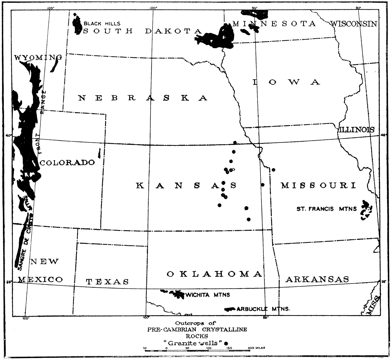
Concerning the time when the granite was uplifted into its present position there is more question. Beds of Cambrian and Ordovician age, including also in some areas regular sequences of Silurian, Devonian and Mississippian strata, overlie the granite in the places here it is exposed, proving that during these times the granite was covered by the sea. In Kansas the crystalline basement of the eastern part of the state is covered by Cambrian, Ordovician, Mississippian and Pennsylvanian beds, but the granite of central Kansas is overlain by rocks of Pennsylvanian age only (see Plate XII). The absence of rocks older than the Pennsylvanian, in the latter case, may be accounted for by the supposition either that they have never been deposited in this region, or that they have been deposited as in neighboring areas but have been removed by subsequent erosion. The second alternative seems almost certain, for not only is there a general lack of clastic material in many of the beds of these systems in eastern Kansas, but a relatively small granite mass such as that of central Kansas must in no long time have been worn entirely away. It is confidently believed that the granite was not an elevated land mass in early Mississippian time, for the seas of the Osage epoch from New Mexico to northern Iowa and Illinois were remarkably clear, as evidenced by the almost complete lack of clastic material in the Osage deposits. The Mississippian sea entirely covered the higher Ozark land (Bridge, Josiah, 1917, p. 558-575) in Missouri, and may be presumed to have flooded all of the Kansas region. However, the Mississippian does not now overlie the Nemaha granite in central Kansas, and it must be assumed that if Mississippian strata did at one time cover it they have been removed by erosion before deposition of the Pennsylvanian in the district. This indicates a rather pronounced though local deformation in central Kansas in late Mississippian or early Pennsylvanian time, followed by rapid erosion which removed all of the sediments covering at least the top of the granite. Evidence from adjoining areas appears to support such an assumption. The Mississippian of southeastern Kansas and about the Ozark highlands was exposed and deeply eroded before Pennsylvanian sedimentation in the region, although no deformative movement other than tilting of the beds has been recognized. To the south, however, especially about the Arbuckle and Wichita mountains of Oklahoma, there appear to have been very pronounced orogenic movements at this time. In the Arbuckle mountains there was extensive faulting and folding, in which 6,000 to 8,000 feet of sediments were uplifted into a mountain area of considerable relief (Taff, J. A., 1904, p. 37). It is very possible that the considerable adjustment of the southern Oklahoma region was accompanied by a similar movement in Kansas. Pennsylvanian and Permian sediments completely buried the Nemaha mountains, probably the Wichitas and perhaps the Arbuckles. The cover of later deposits has been largely removed from the southern mountain belts, but still buries the northern. While not conclusive, it seems most probable that the Nemaha mountains were uplifted in late Mississippian or early Pennsylvanian time.
Geologic History of the Crystalline Rock Area
In concluding the discussion of the buried granite of central Kansas it will be of interest to summarize the geologic history of the region so far as indicated by present knowledge. Data are unfortunately by no means so complete as desirable, since the older rock divisions are not exposed in Kansas, but sufficient is known from a study of deep-well records and from an examination of closely adjacent areas in which the older beds are exposed to form a fairly consecutive though general account of the chief geologic events. These will be described under the head of their respective geologic divisions.
Archeozoic Era
The earliest time of which evidence has probably been found in the Kansas region is the Archeozoic, to which are provisionally referred the crystalline rocks which have been encountered in deep borings within the state. Proof that the exposed crystalline rocks of surrounding regions (Fig. 24) are Archeozoic in age is by no means conclusive, but this is most likely. Presuming the correctness of this correlation, Archeozoic time in this area may be pictured as a period of inconceivably long duration, in which sediments were accumulating as in other areas, but characterized especially by great mountain-making movements accompanied by enormous intrusions of granite and other igneous rocks. From samples of the crystalline basement which have been obtained in Kansas wells it seems that there were later intrusions of a basic magma into the granite, forming diabase dikes, and at least in some places intrusions of an acid magma into small fissures, forming dikes of quartz porphyry. It is possible that some of the intrusions are Proterozoic or younger but all of the igneous complex was probably formed before the Cambrian. The granite, having cooled and crystallized deep' below the surface, was laid bare and extensively eroded, in the latter part or probably at the close of the Archeozoic Era.
Proterozoic Era
No definite record of the Proterozoic is found in Kansas, but rocks which in all probability are referable to it are known in the surrounding areas of Pre-Cambrian rocks. These are more or less altered sedimentary rocks for the most part, and are chiefly clastic in origin, having been derived from the weathering and erosion of exposed masses of Archeozoic rocks. The hard quartz sandstone or quartzite above the granite in the Yates Center, Neodesha and perhaps in the Iola wells is either late Proterozoic or early Cambrian. Exposures of similar quartzite in South Dakota, Iowa and Minnesota are regarded as Proterozoic in age. The era was probably one of extensive erosion and deposition, the sediments in the Kansas region being for the most part clastic in character. As in other regions, there may have been great mountain uplifts, accompanied by extensive folding and faulting of the rocks, perhaps associated with considerable igneous activity. Before the beginning of Cambrian sedimentation there was very widespread, long-continued erosion, in which the country was reduced to a nearly level plain. This is inferred from the close accordance of the stratification of the Cambrian beds with the very even surface of the crystalline floor beneath.
Paleozoic Era
The Paleozoic, as recorded by deposits in the Great Plains country, was a long interval of alternate deposition and erosion in which very thick accumulations of all kinds of sediments were laid down and in part carried away again. The deposits contain fossil remains of the life which existed at the time they were formed, and may be interpreted in a much more detailed manner than any preceding part of geologic time. The Paleozoic was a time of relative quiet in the Kansas region, not marked by igneous intrusions on a large scale, nor for the most part by mountain-making movements, The main events of the Era so far as they are known, may be summarized briefly under the head of its various subdivisions.
Cambrian. In early and perhaps middle Cambrian time Kansas was a lowland upon which the sea was gradually encroaching. Strata of Lower and Middle Cambrian age are not found in the central and upper Mississippi valley, but the Upper Cambrian sea extended very widely to the north and west. In late Cambrian time, therefore, although strata of this age have not certainly been identified in the deep well borings of Kansas, the sea doubtless flooded the entire territory now included in the state, and deposits, largely clastic in character, were laid down.
Ordovician. There seems to have been no important interruption of sedimentation in the Ozark region between the Cambrian and Ordovician periods, and the sea may be assumed to have remained over all of Kansas throughout the great portion of the period. The chief deposits of the Ordovician seas in this region were very thick limestones, now largely changed to dolomites, but beds of sandstone and shale were also formed. The thickness of the Ordovician sediments in many parts of Kansas is probably not in excess of 1,500 feet, but in neighboring regions, as the Arbuckle and Wichita mountains of Oklahoma, limestones up to 6,000 feet in thickness were deposited.
Silurian and Devonian. No strata of Silurian or Devonian age have been recognized on the west side of the Ozarks. [E. M. Shepard (Geology of Greene county: Mo. Geol. Survey, vol. 12, 1898) has described thin local deposits of magnesian limestone and shale in southwestern Missouri, but recent unpublished studies by one of the authors make very doubtful this correlation. It is believed, also, that the sandstone (Sylamore) and shale (Chattanooga) of northern Arkansas, and their equivalents about the Ozark highlands are lowermost Mississippian rather than Upper Devonian, as previously generally correlated.] though limestones of Middle Silurian (Niagaran) age and sandstone and shale of possible Upper Devonian age are known in northeastern Oklahoma, northern Arkansas and northeast of the Ozarks. If Kansas was submerged by the sea at any time during these periods, there is no present indication of the fact. It is very possible that the sea may have advanced at least for short intervals over Kansas, but that in the succeeding times of emergence the deposits laid down were eroded away; or the buried deposits may be present within the state but undiscovered or unrecognized.
Mississippian. In early Mississippian time the sea began a new inundation of the land. About the borders of the Ozark highland, which was then an. island, clastic sediments consisting of mud and sand were deposited, but it is possible that in Kansas, which may previously have been invaded by the sea, the deposits of early Mississippian time were essentially calcareous. Certainly by the beginning of the Osage epoch the sea had advanced widely over the whole central Mississippi valley region, covering all of eastern Kansas, Missouri, Iowa and parts of adjoining states. The water was unusually free from land-derived muds, as evidenced by the thick, very pure limestone deposits and the almost complete lack of clastic sediments. The limestones of the Mississippian sea have been encountered throughout most of eastern Kansas. No highlands could well have existed along the borders of this Mississippian sea, and it is definitely known that the Ozarks were almost entirely if not completely submerged (Bridge, 1917, p. 558-575).
Pennsylvanian. In late Mississippian or early Pennsylvanian time there were pronounced changes in the neighborhood of Kansas. As evidenced by the uneven surface of the Mississippian in southeastern Kansas, Missouri and other states, the region was elevated into land and somewhat extensively eroded. In Oklahoma, as already described, there were very pronounced mountain-making movements in late Mississippian or earliest Pennsylvanian time, and it seems probable that at this time parts of central Kansas were similarly uplifted into a range of mountains-the so-called Nemaha mountains. As soon as elevated above the sea rapid erosion began, attacking first the recently deposited Mississippian sediments, then the underlying rocks of lower Paleozoic age, and finally the granite basement. How long erosion was continued is not known, but before the Pennsylvanian sea covered the region all of the sedimentary rocks had been removed from at least the upper parts of the mountains, for in all the wells which have been reported the granite immediately underlies sediments of the Pennsylvanian. That there was a longer erosion interval just preceding Pennsylvanian sedimentation in Kansas than in many other states is suggested by the fact that the Cherokee shale is distinctly younger than the basal Pennsylvanian of those areas.
This interval of erosion in late Mississippian and early Pennsylvanian time was followed by a general depression of the land and a consequent invasion of the Pennsylvanian sea, which reached the base of the Nemaha mountain range. It gradually rose until the low saddles were submerged, and finally covered even the highest peaks. The thick succession of sandstones, shales and limestones which border and cover the granite ridge are evidence of the long period of submergence beneath the Pennsylvanian sea.
Permian. The deposition of limestones, shales and sandstones continued without break into the Permian period in the region of the granite ridge, and we may infer the nearly continuous presence of the sea almost to the close of the Paleozoic Era.
At the close of the Paleozoic the region suffered slight but extensive orogenic movements, reaching outward from the Ozark highlands, where the upheaval was greatest. This gave the strata of eastern Kansas a general inclination toward the northwest and developed various minor folds in the rocks. Undoubtedly the presence of a resistant mass of crystalline rock projecting far into the strata in central Kansas caused opposing pressures here and developed folds over the ridge, and thrusting and sliding of the strata. Wright (1917, p. 1118) has suggested such thrusting in his explanation of the structures. The movements in the overlying strata probably also affected the crystalline rocks and resulted in some of the slickensided and chloritized rocks found in portions of the basement complex.
Post-Paleozoic History
The later history of the region is one involving minor changes of level and erosion cycles, with little evidence of later deposition in the area immediately in question. The real history of the crystalline rock area is therefore completed, so far as indicated by the data at hand.
Summary
The existence of a large body of crystalline rock within a relatively small distance from the surface in central Kansas is attested by numerous deep borings.
The crystalline mass has the form of a rather narrow ridge 10 to 25 miles in width but nearly 175 miles long, trending in a northeast-southwest direction from the Nebraska state line near Bern to northern Butler county, Kansas.
The ridge appears to reach its highest elevation and to approach the surface most nearly in Nemaha county, northern Kansas, where it is about 600 feet above sea level. Its maximum height above the surrounding crystalline floor is probably at least 2,500 feet. Some wells have been drilled apparently near the crest of the granite ridge, others some little distance down the flanks.
The material of the crystalline mass is for the most part a typical granite. Quartz porphyry and chlorite schist have also been identified.
The uniformity in texture of the granite and the entire absence of metamorphism and of pronounced structural displacements of the strata above the granite are evidence that the mass is not an intrusion into the Pennsylvanian beds.
The same facts, and the presence in the sediments of material possibly derivative from the granite, make most plausible the hypothesis that the granite is on uplifted portion of the Pre-Cambrian crystalline floor.
The age of the granite is probably Pre-Cambrian.
The time of uplift of the ridge is not definitely known, but is probably late Mississippian or early Pennsylvanian.
The ridge, which at the time of its uplift was a prominent mountain range, is here named the Nemaha mountains.
Prev Page--Stratigraphy || Next Page--Physical and Chemical Properties
Kansas Geological Survey, Geology
Placed on web Aug. 10, 2018; originally published 1917.
Comments to webadmin@kgs.ku.edu
The URL for this page is http://www.kgs.ku.edu/Publications/Bulletins/3/08_crys.html