![]()
Prev Page--Contents || Next Page--Previous Work
Chapter I—Historical Outline of the Oil and Gas Industry in Kansas
By Erasmus Haworth
So complete a history of the development of oil and gas in Kansas was published in volume 9 of the University Geological Survey publications it would seem entirely unnecessary to do more here than merely to outline the history as already published, in order that those who do not have access to volume 9 may obtain' a correct though brief history of Kansas production.
Early Development
It should be remembered that the now famous "Colonel" Drake well, near Titusville, Pa., was completed late in August, 1859. It so happened that Dr. G. W. Brown, editor of the Herald of Freedom, at Lawrence, formerly lived near Titusville. During the winter of 1859-'60 he visited his old home and caught the spirit and enthusiasm for oil development which was so prominent around Titusville at that time. On his return to Lawrence in the spring of 1860 he organized a company for the purpose of developing oil around Paola. In earlier days Mr. Searle, a surveyor, and others had noted and reported oil seeps on the Wea and other streams to the east, northeast and southeast of Paola. These seep's led to a belief that oil could be found by drilling in a similar manner to the method employed in Oil creek, near Titusville. A result of Doctor Brown's enthusiasm was that three different wells were begun near Paola during the summer of 1860, making Kansas virtually the second state in the Union engaged in a serious attempt at finding oil. The Civil War followed immediately, and all attempts at oil development were abandoned until later.
Southeastern Oil and Gas Fields
It is difficult to learn the exact date when the next well was begun, but Paola seemed to be a center from which the enthusiasm spread in many directions. It was here that men learned to drill wells substantially the same as they learned it in Pennsylvania. It was here that gas was first piped into the city for the express purpose of producing light and heat. It was here that the first oil in commercial quantities was obtained, and all of this primarily on account of the many oil seeps found in so many different places in Miami county. Prospecting spread south into Linn county and north into Johnson and Wyandotte counties, and a number of gas wells were obtained.
Later development extended to the south and southwest by way of Osawatomie, Paola, Neodesha and down as far as Independence and Coffeyville. Not much was done in the southern part of the state, however, until what we might call the third period of development, counting the Doctor Brown attempt at Paola the first, and those just mentioned the second.
Beginning in 1891, and becoming quite active in 1892 and very enthusiastic by 1893 and 1894, prospectors covered the entire southeastern part of Kansas along the Neosho and Verdigris rivers, and much development resulted, particularly in Allen, Neosho, Montgomery and Wilson counties.
In 1891 Mr. W. M. Mills came west from Pennsylvania and was so impressed with the favorable conditions around Neodesha, Thayer and other points that he went back to Pittsburg and prevailed upon the developing firm of Guffey & Galey to come west and begin a series of developments on a large scale. He chose for his field of action Osawatomie and vicinity, while they made their headquarters at Neodesha. Success followed them to a sufficient extent so that in 1894 they sold their entire holdings to the Standard Oil Company, which took possession of the property and immediately began a more extensive development. Soon the Standard Oil Company erected a refinery at Neodesha, which has been enlarged from time to time until it is now one of the large refineries of the country.
In a short time the name of the operating company was changed to the Prairie Oil and Gas Company, under which name it is still known. Within the last two years a subdivision of this company has been made, so that we now have the Prairie Pipe Line Company as a subsidiary of the Standard Oil Company.
During these years much activity was manifested by independent companies, so that both oil and gas were obtained in large quantities throughout substantially all of the counties above named, and the western half of Labette county as well. To the northeast, Anderson and Franklin counties claim considerable notoriety, and Miami county, where development was first begun, likewise has been a center of drilling operations from the earliest time to the present.
During this period of development a very large amount of natural gas was obtained. Its production is localized with the production of oil, for scarcely can one name a productive field of either which does not likewise produce the other. Every town and village of any considerable size throughout the entire productive area has been heated and lighted with natural gas for more than twenty-five years, and there is scarcely a farmhouse in the entire area which is not similarly supplied. It was a natural result, therefore, that a great combination of interests should be effected and large companies formed for piping gas out of the territory in which it was produced.
The Kansas Natural Gas Company was formed by combining the gas holdings of a number of large companies and selling bonds to raise money for laying pipe lines and extending development. It constructed pipe lines to the north during the summer of 1905, reaching Lawrence, Topeka, Leavenworth and Atchison that autumn, and St. Joseph and Kansas City, Mo., a year later. Branch lines were built to all intermediate towns, so that substantially all of the eastern part of the state was supplied. A year later the Wichita Natural Gas Company built pipe lines westward to Wichita and Hutchinson and intermediate places. These main pipe lines have supplied gas reasonably well from the time of their construction to the present. During this period many individual gas fields failed and have been abandoned, but new ones have been found, and the gathering pipe lines have been extended so that the supply has been reasonably well preserved, although it is growing scarcer year by year.
Oil and Gas in Butler County
Enthusiasm over oil and gas finding is contagious. With the successful development of fields in southeastern Kansas citizens all over the state began hoping that their localities likewise might become productive. As a result wells were drilled promiscuously here and there all over Kansas. It is doubtful if there is a single county in the state which has not had at least one well drilled by some enthusiast. For some reason citizens in the Walnut river valley, particularly in Butler county, had the belief that oil and gas could be developed there. At Augusta, Hon. N. A. Yeager took a very active part in prospecting. In fact, when history is correctly written, Mr. Yeager will be given credit for being the prime cause of development in his vicinity. Although a lawyer, he became a student of geology and studied the geology of oil and gas very carefully. Not being supplied with proper apparatus he used a carpenter's spirit level for determining dip of strata, and thereby located the eastern one of the Augusta anticlines, and had wells drilled upon it, substantially everyone of which became a producer of gas in commercial quantities. Augusta was supplied with gas years before oil was discovered. It has been many years since the streets of Augusta first were lighted with natural gas from wells located by Mr. Yeager.
In 1912 the Kansas Natural Gas Company employed the writer and his son, Huntsman Haworth, to help them find promising gas territory. After examining a few points named by the gas company the writer was called upon to choose his own territory, whereupon he went at once to the Walnut river valley. Previous to this time a small amount of gas had been found at Winfield and a relatively large amount at Augusta. It was known to geologists that a line of anticlines lay substantially within the Walnut river valley. The method of investigation employed was to cross this area, measuring with precision the anticlines found. The first cross-section was run east and west just below Parker, a little town in Morris county. The same line of anticlines was cross-cut at Wilsey on the Missouri Pacific, and again at Elmdale where an anticline had been known for years and had been partially developed on the advice of Dr. J. W. Beede, an assistant on the Kansas State Geological Survey. From Elmdale examination was made southward to Burns, across the anticline there and southward to El Dorado.
El Dorado
In the vicinity of El Dorado, county seat of Butler county, a well-defined anticline, which has since been developed into the remarkable El Dorado field, was discovered by the examination of the writer and his son. A line of levels was run from the western part of the city across the summit of the anticline and down the east side. The strata were found to slope downward fifty or sixty feet on the east and a somewhat greater amount on the west, the western dip, however, changing gradually to the normal dip of the region, about twenty-five feet per mile. Weekly reports of the geologic work were sent in and blue-print maps, of which Figure 1 is a reproduction, were drawn showing the line of the summit of the anticline. In September, 1912, the writer advised his clients to get leases on either side of the axis of the anticline covering a strip two or three miles in width, but the advice unfortunately was neglected.
Figure 1—Field map of a portion of Butler county made in 1914 by Haworth and Haworth, showing anticlinal structure near El Dorado and Augusta. The two small heavy-lined rectangles show cross-sections of the anticline.
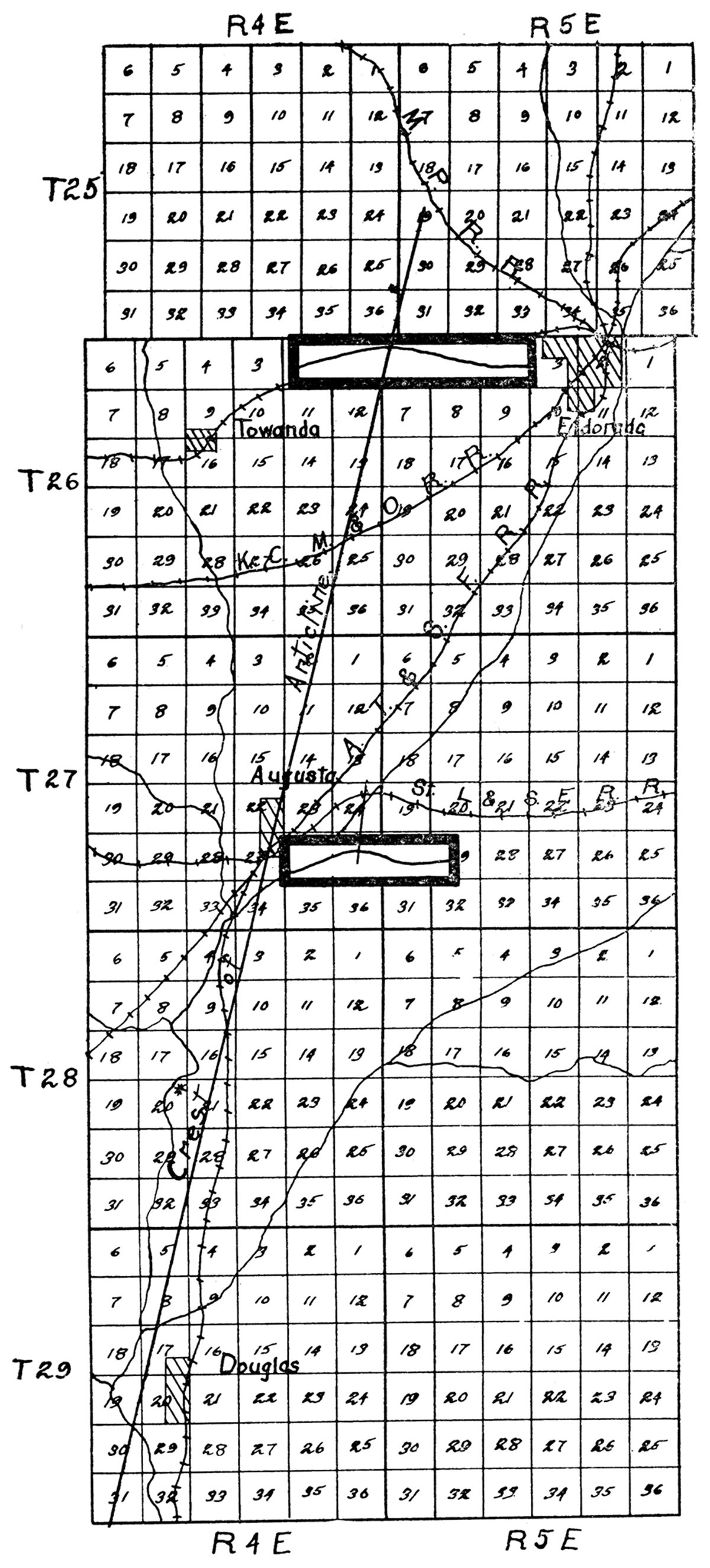
In 1914 the city council of El Dorado asked for help in the location of natural-gas deposits. An investigation similar to the earlier one just described, but without precise measurement with levels, was begun, and, assisted especially by Mr. Austin, a surveyor from El Dorado, the anticline west of town was outlined substantially as mapped in 1912.
Since oil had been found at Augusta it was advised that development of the El Dorado structure be prosecuted actively, recommendation being made that the first well be drilled close to the crest of the anticline. Accordingly the city drilled a well in Sec. 1, T. 26 S., R. 4 E. After expenditure of thousands of dollars, the well, dry, was abandoned at a depth of about 2,650 feet. A short time later the Wichita Natural Gas Company, now the Empire Gas and Fuel Company, whose geologists had made a careful survey of the area, took over the property from the city of El Dorado and paid them their entire outlay. At once a well was drilled on the Stapleton land in the southeastern quarter of Sec. 29, T. 25 S., R. 5 E. At a depth of 590 feet a sand was reached which produced oil, and at 670 feet another oil sand, the two together producing substantially 150 barrels per day. This was the beginning of development in the El Dorado field.
Shortly after the production of oil on the Stapleton land, some who paid little attention to geology went down the east side of the anticline, almost to the syncline trough, and obtained 1,000-barrel wells. This implied that the oil pool was so large it must fill the entire anticline—a supposition which has been thoroughly established by subsequent drilling. No geologist can determine in advance of drilling whether or not oil lies under an anticline, and if it does, how much. If a sufficiently large body of oil has been concentrated it may entirely fill the anticline and reach down the sides to the syncline troughs. It seems that the El Dorado anticline is thus filled.
As oil was first discovered on the east side of the El Dorado structure, operators naturally clung to this side rather than to the west. Gradually, however, operations were extended across the summit and down the western slope, so that to-day some of the best development in the district is on the west side of the arch. The famous Trapshooter well, recently drilled a little west of the center of Sec. 11, T. 26 S., R. 4 E., is a little more than a mile west of the summit as outlined on Haworth's map of 1912. An almost equally good oil producer has been drilled by the Carter Oil Company a few hundred feet south of the Trapshooter well. A gas well with 20,000,000 feet capacity has been drilled in section 12, just east of the Trapshooter well. It is located near the crest of the arch where gas is supposed to be, if found at all, and is an excellent confirmation of present ideas of the geologic relations of gas, oil and water. Local oil and gas journals speak of these new wells as developments in the Towanda district, implying that they constitute a new field. It is true that they are in the municipal township named Towanda, but it is much more important to note that they are on part of the El Dorado anticline, and are, therefore, geologically and geographically a part of the great El Dorado field, and from every standpoint should be referred to in that way.
Augusta
Developments at Augusta have followed the lines which the geology of the district imply. The greatest oil developments to date are on an anticline west of town, lying principally beneath the alfalfa fields of the Walnut river valley. The Augusta anticline was observed in part by the Haworths in 1912, but as the area is principally occupied by river alluvium it was given but little attention. A few deep wells have been drilled on the main anticline farther east, but development has not been carried to a sufficient extent to indicate certainly what the final results may be. From a geologic standpoint it seems that this anticline may prove as productive as any.
Just west of the line between ranges 4 and 5 a third anticline with a relatively short north-and-south extension is found. Here the rocks have the greatest dip of any place examined in Butler county, and it will not be surprising should a pool with very large producing wells be discovered here.
Other Localities
Good oil wells have been found at scattered points in other parts of Butler county. One of these is on the Smock land (Sec. 2, T. 27 S., R. 5 E.), six miles south of El Dorado. On the Weaver land (Sec. 1, T. 28 S., R. 5 E.), six miles farther south, is another well of considerable importance, and a number of wells have been found in T. 29 S., R. 4 E., northeast of Douglass. There has been much speculation as to the possibility of finding quantities of oil in other parts of the Butler county region. Since oil has been found almost continuously over a large part of eastern Kansas, it may well be hoped that oil will be discovered at many other places in Butler county and adjoining areas to the north and south.
Present Condition of the Oil and Gas Industry in Kansas
Prices quoted on Kansas petroleum are the highest ever known—$2 per barrel (October, 1917)—but in reality they are much higher, as almost all Kansas oil is selling at a premium. Development work is, therefore, very active despite the scarcity of gas for drilling and the high price of labor. It is idle to attempt a forecast of what, the future has in store for Kansas. A few years ago one of the great oil geologists (Arnold, 1916) of the country estimated the total production that might be expected from Kansas. After showing the total output of Kansas to the date of his article, he multiplied the total by two, and assumed that Kansas under favorable circumstances might do as much in the future as she had done in the past. During the year 1916 alone, however, Kansas produced almost as much oil as shown in her entire previous output. Throughout the first half of the present year she has averaged more than 75,000 barrels per day, which if continued to the end of 1917 will have carried the production far beyond the sum total estimated by the writer mentioned. Leaving out of consideration the discovery of any substantially new areas, it is not a vain hope that the daily output of Kansas will be increased rather than decreased throughout the next two years.
Prev Page--Contents || Next Page--Previous Work
Kansas Geological Survey, Geology
Placed on web Aug. 10, 2018; originally published 1917.
Comments to webadmin@kgs.ku.edu
The URL for this page is http://www.kgs.ku.edu/Publications/Bulletins/3/02_hist.html