![]()
Prev Page--Mineral Resources || Next Page--References
Pennsylvanian Invertebrate Faunas of Southeastern Kansas
by James Williams
Introduction
One hundred sixty-eight collections of Pennsylvanian invertebrate fossils were made in connection with this investigation of the southeastern Kansas coal field. Most of the fossils were collected from the Cherokee shale, but a few were obtained from the overlying Fort Scott and higher Pennsylvanian formations. All of them came from Crawford, Cherokee, and Labette counties, Kansas, except for a few collections from nearby areas in Missouri. All were made coincident with the preparation of a detailed map, during an investigation of the geology and coal resources of the above counties, and they are therefore carefully and definitely located, both stratigraphically and geographically. In the progress of mapping, many contacts were followed for fairly long distances and the beds were correlated between outcrops by the use of the records of drill holes that, in most areas, were very closely spaced. Many of the collections were made from rather thin zones at closely spaced localities. The true faunal characters of the various zones should thus be revealed, with little danger of incorrect correlations. In few areas has the Cherokee shale been so thoroughly or carefully searched for fossils.
The Cherokee shale constitutes only a relatively small part of the entire Pennsylvanian section and accordingly the results of the studies do not show great faunal differences. In general, the results tend to confirm previous concepts of the range and value as horizon markers of the species studied. They demonstrate the difficulty encountered in some regions of identifying thin beds or thin formations in widespread random outcrops, either by lithology or by the common faunal method of contrasting the ranges of various species. They also demonstrate, however, that although the exact position of a bed can but rarely be determined by these methods, it is nevertheless often possible to recognize its approximate position through knowledge of the ranges of its faunal elements.
The species that have such limited ranges in this area that they are most useful in the establishment of approximate correlations with distant beds are the following forms--corals, bryozoans, and brachiopods: Chaetetes milleporaceus Edward and Haime, Prismopora triangulata (White), "Productus" (Linoproductus) insinuatus Girty, "Productus" (Echinoconchus) semipunctatus knighti Dunbar and Condra, Marginifera munricatina missouriensis Girty, and Spirifer cf. S. rockymontanus Marcou. Certain species of pelecypods and gastropods not critically studied in the present work are likely, also, to be of value as guide fossils. The first four named species are found in the southeastern Kansas coal field, only in the upper part of the Cherokee and higher beds, but the assurance with which they can be used is lessened by the occurrence of Chaetetes milleporaceus in Morrow beds in eastern Oklahoma and of species of Prismopora close to P. triangulata in lower Cherokee or older beds. The other species are characteristic of lower Cherokee in Kansas. The utility of most of the pelecypod and gastropod species is diminished because of their relative scarcity.
The relative abundance of certain long-ranging species and varieties is a means of identifying certain beds. Such species are Marginifera muricatina Dunbar and Condra and Chonetes (Mesolobus) Norwood and Pratten, which are especially abundant in the Cherokee formation, and Chonetes (Mesolobus) mesolobus euampygus Girty, which is more abundant in the Fort Scott limestone than in the Cherokee.
Invertebrate fossils of the Cherokee and immediately overlying beds are most useful in correlation of nearby outcrops when consideration is given to the associated lithologic sequences. For this purpose the relative abundance of various species, as well as the ranges and the total faunal composition, is important. Possible changes of faunules due to lateral changes in ecological conditions, including lithologic or facies changes, to migration, to different basins of deposition, or to the accidents of collecting must also be borne in mind constantly. When all these things are considered, the faunules aid materially in the solution of many stratigraphic problems, and permit the recognition of thin zones within the Pennsylvanian series.
Extensions of the reported ranges of several species, especially within the Cherokee formation, were noted in connection with the study of these collections. These extensions need not be mentioned here, but they can be determined by reference to the faunal tables and comparison with previously published tables.
A real or at least apparent relation between lithologic facies and certain types of faunules is shown by a number of collections. All of the conodonts collected came from black fissile "paper-thin" shales, but possibly conodonts are present in other shales that were not carefully examined. Small coiled cephalopods and fragments of fish bone were most commonly found in phosphatic nodules in black fissile shales. Aviculipecten rectilaterarius (Cox) is commonly found in black shales, but it also occurs sparingly in tan shales; at some localities it is associated with plants. Most of the species in the limestones and calcareous shales are of brachiopods, but corals, especially Chaetetes, are common in some limestones, and this one genus is more or less restricted to limestones. Small gastropods, occasional small cephalopods and small pelecypods, are the predominating fossils in some calcareous zones that are also pyritic or otherwise ferruginous. These suggest that depauperizing conditions existed when these beds were deposited.
Complete fossil lists are given for most, but not all, of the collections. A few of the collections have not been thoroughly studied and only the general characters of their faunules are shown in the tables. Most detailed identifications were made of forms which, because of good preservation or unusual occurrences, seemed to promise stratigraphically useful results. Other forms are referred to the genera to which they belong without a specific determination. Quotation marks around a fossil name indicate that I recognize objections to the way the name is being used, but am not ready to decide what changes, if any, should be made.
The identifications on which this report is based were made during May and June 1935. Changes in nomenclature made in literature reaching my hands after June 1935, are not shown in this report. Some few changes made in literature published before this date are not included either, because I disagree with them on morphological or philosophical grounds or because I have misgivings about them. None of the species here listed in name combinations different from those used in other recent papers will be misunderstood.
This report deals only with the larger invertebrates, plants, and fusulinids being mentioned in the text under the discussion of the zones from which they were collected.
Collections from the Pawnee Limestone
Two collections from the Pawnee limestone were studied, one from central northern Crawford County, Kansas, and the other from northeastern Labette County. At both localities Squamularia perplexa (McChesney) is the most common species. Other fossils are rare.
| Fossils from the Pawnee limestone, about 1 mile south and 2 1/2 miles east of Farlington, Crawford County (Collection 7806): |
|---|
| Fusulinids (r) |
| Lophophyllum profundum (Edwards and Haime) (r) |
| Chaetetes milleporaceus Edwards and Haime (r) |
| Crinoid stem joints |
| Crurithyris? planoconvexa (Shumard) (r) |
| Squamularia perplexa (McChesney) (a) |
| Fossils from the Pawnee limestone, about 5 miles north and 14 mile west of Montana, Labette County (Collection 7808): |
| Horn coral, undeterminate fragment |
| Crinoid columnals |
| "Productus" (Dictyoclostus) sp. indet., fragments of brachial valve |
| Marginifera wabashensis (Norwood and Pratten) var. A |
| Squamularia perplexa (McChesney) (a) |
| Composita subtilita (Hall) |
On the basis of these collections alone, one would judge that the Pawnee is characterized by an abundance of squamularias and a scarcity of other invertebrates. This type of faunule is typical of many outcrops in the area, but is not diagnostic of a particular horizon.
In most places the Pawnee limestone is much less fossiliferous, both in individuals and species, than the underlying Fort Scott limestone. At some places, however, as in Vernon County, Missouri, the Pawnee has abundant Chaetetes and locally elsewhere, especially in Kansas, considerable faunules have been obtained. On the other hand, at a few localities within the area of this report the Fort Scott limestone is sparsely fossiliferous.
A number of species that occur in the Fort Scott and lower limestones are not yet known from the Pawnee. Only a few Pawnee limestone species are unknown from the Fort Scott or beds below it in Missouri. Girty (1915) listed five such species from the Pawnee of Missouri, which he thought lacked significance, because they were either rare forms or insecurely identified. Condra and Dunbar (1932) show four in their report on the Nebraska Brachiopods--their Dictyoclostus americanus, Linoproductus magnispinus, Cryptacanthia compacta (White and St. John), and a chonetid designated by them as Chonetina flemingi. The first species was discovered from the Fort Scott in the present investigation. A form from the Fort Scott, which is here called "Productus" (Linoproductus) prattenianus n. var., is closely related to their L. magnispinus and may actually be the same form. The other two species are rare in the Pawnee and were not collected during our studies. Beede and Rogers (1904) list about a dozen species from five localities in Kansas, but most of them are mollusca or other forms that are rare in the limestones of this part of the stratigraphic column. Our collections show no species of invertebrates that does not also occur in the Fort Scott. Consequently, the identification of the Pawnee in this area rests largely on stratigraphic tracing, on the absence of species known elsewhere only from lower formations, and on the identification of the Fort Scott limestone with the Fort Scott of the type region and of nearby regions in Missouri.
Collections from the Labette Shale
Collections were made from three zones in the Labette shale. One came from a black shale, probably from beds only a few inches below the top of the formation, three are from a zone from 6 to 7 feet lower, and two are from a zone 22 feet below the top of the Labette shale.
The collection (number 7799) from the black shales at the top of the Labette is from eastern Labette County, 1 3/4 miles west and 1/2 mile south of Montana, and is composed wholly of fragments of fish bone in black nodules.
The three collections from the zone 6 to 7 feet below the top of the Labette shale came from a thin black limestone. One of these collections contains the following forms.
| Fossils from the upper Labette shale 6 miles north and 1 mile west of Montana, Labette County, Kansas (Collection 7797): |
|---|
| Horn coral, indeterminate fragment |
| Crinoid columnals |
| Derbya crassa? (Meek and Hayden), fragment of young |
| Chonetes (Mesolobus) mesolobus lioderma (Dunbar and Condra) |
| Composita subtilita (Hall) |
| Phanerotrema? sp. indet., crushed specimen |
The following forms were identified in another collection from approximately the same locality. Except for the corals, the individuals are all small and the fauna may be depauperate. Many indeterminate fragments of small shells are visible on the surfaces of slabs.
| Fossils from the upper Labette shale, 6 miles north and 1 mile west of Montana, Labette County, Kansas (Collection 7798): |
|---|
| Lophophyllum profundum (Edwards and Haime) |
| Crinoid columnals |
| Fenestrellina? sp. indet., non-poriferous side. |
| Derbya sp. indet. |
| Chonetes (Mesolobus) mesolobus? Norwood and Pratten |
| Crurithyris planoconvexa (Shumard) |
| Hustedia mormoni (Marcou) |
| Meekospira? sp. indet., section on a slab |
| "Griffithides"?, fragment on a slab |
The third collection (No. 7807) is from about 1 3/4 miles south and three fourths of a mile west of Montana. It consists of a single individual, a well-preserved specimen of Derbya crassa (Meek and Hayden).
The two collections from the zone 22 feet below the top of the Labette shale are from a single locality, about 2 miles west of Englevale, Crawford County. They were made from a black limestone, probably not over a few inches thick. Fossils are very common, especially small and fragmentary shells, and they are conspicuous because of the contrast between white shells and very dark matrix. Some small slabs resemble coquina, but few of the shells in them are identifiable. A combined but incomplete list of these two collections is given below. The most common forms are the derbyas and crinoid columnals.
| Fossils from zone 22 feet below top of Labette shale, 2 miles west of Englevale, Crawford County, Kansas (Collections 7809, 7810): |
|---|
| Lophophyllum? profundum (Edwards and Haime) |
| Other horn corals, probably 1 species |
| Crinoid columnals |
| Rhombopora lepidodendroides Meek |
| Derbya crassa (Meek and Hayden) |
| Chonetes (Mesolobus) mesolobus lioderma (Dunbar and Condra) |
| Chonetes (Mesolobus) mesolobus euampygus? Girty |
| Marginifera wabashensis (Norwood and Pratten) var. A |
| Productoid spines |
| Composita subtilita? (Hall) |
| Bellerophon? sp. indet., internal mold |
| Euphemites carbonarius (Cox) |
Relatively few fossils have been recorded from the Labette shale, the longest list having been contributed by Beede and Rogers (1904) from near Fort Scott, Kan. All of the lists, including those given above, contain only long-ranging or insecurely identified forms, which are not of much value from a stratigraphic standpoint. The records given here are of interest mainly because the collections are from definite zones within the Labette, because they come from near the type locality, and because they extend the range of the brachiopod Chonetes (Mesolobus) mesolobus lioderma. The collections contribute little of value in correlation, and the recognition of the Labette in this area rests largely on stratigraphic data and on the absence of fossils distinctive of other formations. It is supported to a degree by the scarcity of fossils, which distinguishes the formation as a whole from the upper part of the Cherokee shale.
Collections from the Fort Scott Limestone
The Fort Scott limestone consists of two limestone members separated by shale. At many places, especially in Missouri and nearby areas in Kansas, a thin coal occurs in the shale.
Thirty-two collections were made from this formation. Of these, 12 came from the upper limestone member, 19 from the lower limestone member, and one from the shale. The species found in the individual collections are recorded in Plate 10.
Plate 10--Invertebrate species collected from the Fort Scott limestone. (1) Includes one locality from western Cherokee County. Protozoa identifications by L.G. Henbest in preceedeing part of report.
| Upper limestone member | Middle shale member |
Lower limestone member | ||||||||||||||||||||||
|---|---|---|---|---|---|---|---|---|---|---|---|---|---|---|---|---|---|---|---|---|---|---|---|---|
| Crawford County | Labette County | Crawford County | northern Labette County (1) |
southeastern Labette County | ||||||||||||||||||||
| 7793 | 7794-7886 | 7883 | 7792 | 7820 | 7822-7880 | 7881 | 7884 | 7795 | 7780 | 7783 | 7785 | 7786-7787 | 7789 | 7790 | 7784 | 7788-7791 | 7879 | 7796 | 7874 | 7875 | 7876 | 7877 | 7878 | |
| Protozoa | ||||||||||||||||||||||||
| Fusulinids | X | X | X | X | X | X | X | X | ||||||||||||||||
| Anthozoa | ||||||||||||||||||||||||
| Lophophyllum profundum (Edwards and Haime) | X | X | ||||||||||||||||||||||
| Other horn corals | X | X | X | X | X | |||||||||||||||||||
| Syringopora sp. undet. | X | |||||||||||||||||||||||
| Chaetetes milleporaceous Edwards and Haime | X | X | X | X | X | X | X | X | ||||||||||||||||
| Echinodermata | ||||||||||||||||||||||||
| Crinoid columnals | X | X | X | X | X | X | X | X | X | X | X | X | X | X | X | X | ||||||||
| Echinoid spines or plates | X | X | X | X | X | X | X | X | ||||||||||||||||
| Pustulose echinoid spines | X | X | X | X | X | |||||||||||||||||||
| Bryozoa | ||||||||||||||||||||||||
| Fistulipora sp. undet. | ? | X | ||||||||||||||||||||||
| Pinnatopora sp. undet. | X | |||||||||||||||||||||||
| Rhombopora lepidodendroides Meek | X | X | X | X | ||||||||||||||||||||
| Cystodictya sp. undescribed | X | |||||||||||||||||||||||
| Prismopora triangulata (White) | X | X | ||||||||||||||||||||||
| Brachiopoda | ||||||||||||||||||||||||
| Orbiculoidea missouriensis (Shumard) | X | |||||||||||||||||||||||
| Derbya crassa (Meek and Hayden) | ? | X | X | X | ||||||||||||||||||||
| Derbya sp. undet. | X | |||||||||||||||||||||||
| Meekella stratiocostata (Cox) | X | |||||||||||||||||||||||
| Meekella stratiocostata grandicosta Dunbar and Condra | X | |||||||||||||||||||||||
| Chonetes flemingi crassiradiata (Dunbar and Condra) | X | ? | X | |||||||||||||||||||||
| Chonetes (Mesolobus) mesolobus euampygus Girty | X | X | ||||||||||||||||||||||
| "Productus" (Dictyoclostus) americanus (Dumbar and Condra) | ? | X | X | |||||||||||||||||||||
| "Productus" (Dictyoclostus) portlockianus Norwood and Pratten | ? | X | X | X | X | |||||||||||||||||||
| "Productus" (Dictyoclostus) sp. undet. | X | |||||||||||||||||||||||
| "Productus" (Linoproductus) insinuatus Girty | X | |||||||||||||||||||||||
| "Productus" (Linoproductus) prattenianus Norwood and Pratten n. var. | ? | ? | ||||||||||||||||||||||
| "Productus" (Krotovia?) sp. undescribed | X | |||||||||||||||||||||||
| "Productus" (Echinoconchus) semipunctatus knighti (Dunbar and Condra) | X | |||||||||||||||||||||||
| Marginifera muricatina Dunbar and Condra | ? | X | X | |||||||||||||||||||||
| Marginifera wabashensis (Norwood and Pratten) var. A., undescribed | X | X | ||||||||||||||||||||||
| Wellerella osagensis immatura Dunbar and Condra | X | X | X | |||||||||||||||||||||
| Wellerella osagensis tetrahedra Dunbar and Condra | X | |||||||||||||||||||||||
| Spirifer (Neospirifer) cameratus Morton | X | X | ||||||||||||||||||||||
| Spirifer (Neospirifer) sp. undet. | X | |||||||||||||||||||||||
| Crurithyeis planoconvexa (Shumard) | ? | ? | X | X | ||||||||||||||||||||
| Squamularia perplexa (McChesney) | X | X | X | X | X | X | ||||||||||||||||||
| Hustedia mormoni (Marcou) | X | X | X | X | ||||||||||||||||||||
| Cleiothyridina orbicularis (McChesney) | X | |||||||||||||||||||||||
| Composita subtilita (Hall) | X | X | X | X | X | X | X | X | X | ? | X | X | ||||||||||||
| Composita subtilita (Hall) large var. | X | X | X | X | ||||||||||||||||||||
| Pelecypoda | ||||||||||||||||||||||||
| Edmondia sp. undescribed | X | |||||||||||||||||||||||
| Other Pelecypoda | X | |||||||||||||||||||||||
| Gastropoda | ||||||||||||||||||||||||
| Euconospiria sp. undet. | X | |||||||||||||||||||||||
| Straparollus (Euomphalus) sp. undet. | ||||||||||||||||||||||||
| Other Gastropoda | X | X | X | |||||||||||||||||||||
| Trilobita | ||||||||||||||||||||||||
| Phillipsia major Shumard | X | X | ||||||||||||||||||||||
| Vertebrata | ||||||||||||||||||||||||
| Conodonts | X | |||||||||||||||||||||||
Collections from the upper limestone member
Collections from the upper member of the Fort Scott limestone were made in Crawford and Labette counties. The collections from Crawford County, with two exceptions, came from a light-gray, finely crystalline but not dense, limestone which weathers yellow brown. One of the expected collections came from a 3- to 6-inch bed of yellow-brown to olive-drab or light-chocolate-brown, finely crystalline limestone that occurs at some localities above the light-gray limestone and is at the very top of the upper member. The other came from a light-chocolate-gray, finely crystalline limestone. The faunules, taken as a whole, contain many fusulinids and many colonies or "heads" of Chaetetes milleporaceus Edwards and Haime. In places nearly one-third of the limestone beds consist of large or small subspheroidal colonies of Chaetetes and Syringopora. Large crinoid columnals, robust specimens of Composita subtilita (Hall), and individuals of "Productus" (Dictyoclostus) portlockianus Norwood and Pratten, are important elements in the faunules. An unusual type of echinoid spine, which differs from the more common types by having conspicuous pustules on the sides of the shaft, is interesting.
Most of the collections from Labette County are from near Oswego, the type locality of the so-called "Oswego limestone." The faunules and lithologies of the various outcrops are more varied in this county than in Crawford County. The most common type of lithology is very faint purplish-gray to yellow-gray, finely crystalline limestone. At some outcrops the beds are brownish yellow. As in Crawford County, large colonies of Chaetetes, large crinoid stems, large compositas, and individuals of "Productus" (Dictyoclostus) are important elements in the faunules. Fusulinids are less abundant here. The Labette County collections contain several forms such as Meekella striatocostata grandicosta Dunbar and Condra, "Productus" (Echinoconchus) semipunctatus knighti (Dunbar and Condra), and "Productus" (Linoproductus) insinuatus Girty, that were not obtained in Crawford County. The last two of these are unknown from beds older than the Fort Scott, and the first is doubtfully recorded from older beds. Gastropods are more important here than in Crawford County, but the faunules consist chiefly of brachiopods.
Collection from shale between the upper and lower limestone members
Only one collection (No. 7795) was made from the shale between the two limestone members of the Fort Scott. This came from a black shale about 30 inches below the base of the upper limestone in northeastern Crawford County. The only fossils observed were conodonts, which have not yet been studied.
Collections from the lower limestone member
Most of the collections from the lower member of the Fort Scott formation were obtained from faintly purplish-gray, finely crystalline limestone, but some of them are from whitish-gray limestone, and others are from brownish-yellow limestone.
The collections may be roughly grouped into three lots: those from Crawford County, those from northeastern Labette and western Cherokee counties, and those from southeastern Labette County. In all three areas the faunules are largely of brachiopods, with large productid individuals belonging to three or four different subgenera a conspicuous element. Large compositas are also common. The brachiopod assemblages are more varied than in the upper Fort Scott collections. Chonetids, marginiferas, wellerellas, squamularias, and hustedias are forms occurring in several lower Fort Scott collections that are rare or absent from the upper Fort Scott. Fusulinids and Chaetetes colonies are common in collections from Crawford and northern Cherokee counties, but are not commonly seen in collections from southern Labette County. Echinoid spines and prismoporas occur from widely separated areas, but are absent, however, in many localities. Bryozoans and squamularias are relatively more important in southeastern Labette County, but the collections from this area were made hurriedly and may not represent the faunules adequately.
Species in our collections whose occurrence in the Fort Scott of this general region is worthy of note are "Productus" (Dictyoclostus) americanus (Dunbar and Condra), "Productus" (Krotovia?) sp., probably new, Marginifera muricatina Dunbar and Condra, a new (?) variety which approaches var. missouriensis, Wellerella osagensis immatura Dunbar and Condra, a large undescribed species of Edmondia (?), echinoid spines with conspicuous pustules on the sides of the shaft, an undescribed species of Cystodictya, and an undetermined species of Pinnatopora.
Faunal characteristics of members and zones of the Fort Scott limestone
Our collections show a number of forms from the lower limestone that are not in our collections from the upper limestone. These are Pinnatopora (?) sp. indet., Cystodictya n. sp., Prismopora triangulata, Chonetes (Mesolobus) mesolobus euampygus, "Productus" (Dictyoclostus) americanus, "Productus" (Krotovia?) n. sp., Marginifera muricatina, Wellerella osagensis immatura, Wellerella osagensis tetrahedra, and some rare gastropods. Of these, the most significant are P. triangulata, Co. mesolobus euampygus, Cystodictya n. sp. and the Krotovia(?). All the others, except perhaps the Pinnatopora, are listed from the upper limestone or higher beds in nearby regions in other reports. Dunbar and Condra have also reported C. mesolobus euampygus from higher horizons. Beede and Rogers report P. triangulata from both the upper and lower limestones, but our collections suggest it is more abundant in the lower limestone.
Only a few forms from the upper limestone member do not occur in our collections from the lower limestone member. These are Syringopora sp. indet., Meekella stiatocostata granidicosta, "Productus" (Dictyoclostus) portlockianus, "Productus" (Echinoconchus) semipunctatus knighti, and "Productus" (Linoproductus) insinuatus. All of them, with the possible exception of P. insinuatus, have been reported either in the upper part of the Cherokee or the lower member of the Fort Scott, or both, and their absence from our lower Fort Scott collections is probably due to the accidents of collecting.
To the few species discussed above that now serve to distinguish our lower from upper Fort Scott collections, one may add the somewhat greater variety of fossils in the lower Fort Scott at most localities and the greater number of individuals of Chaetetes milleporaceus, Marginifera muricatina, and Prismopora triangulata in the lower Fort Scott. Of course the greater abundance of the above species cannot be used for each individual outcrop but is useful in a broad way.
Beede and Rogers (1904) cite over 30 species from the upper Fort Scott that they do not cite from the lower, and about an equal number from the lower Fort Scott that they do not have from the upper Fort Scott. Most of these species are of mollusks, which are not common in the Fort Scott limestone, and because the reported restricted ranges of at least some of them are probably due merely to the deficiencies of collecting, caution must be exercised in using them for purposes of correlation. Our collections do not contain identifiable specimens of any of the mollusks cited by Beede and Rogers (1904) as distinctive. Few other paleontologists have attempted to compile separate lists of collections for the upper and lower members of the Fort Scott limestone. When this is done on a wide scale some distinctive common forms may be discovered.
Faunal differences between Fort Scott and adjacent formations and regional correlation of the Fort Scott formation
Rather an imposing list of species may be cited from the literature and from our collections to distinguish the Fort Scott limestone from the overlying Labette and Pawnee formations. The utility of this list is somewhat diminished, however, by the facts that more intensive collecting has been done from the Fort Scott than from the other formations and that, with a few exceptions, the diagnostic forms are rare, variable, or incompletely known. However, a few forms are probably truly diagnostic, and under conditions where one is able to trace the beds for several miles and collect from several localities, it is possible to obtain composite collections sufficient to distinguish the Fort Scott from the Pawnee and to correlate it with the Fort Scott of nearby areas. When dealing with individual collections, however, it must be realized that although some individual faunules contain a sufficient number of diagnostic forms to overbalance the likelihood of extensions of the range of one or two species, most faunules do not have enough distinctive forms to permit reliable correlations.
Most of our collections from the Fort Scott differ from those of the Pawnee in that the former contain a greater number and variety of fossils and have a greater relative number of specimens of Chaetetes milleporaceus and Marginifera muricatina. Our collections from the Fort Scott formation, when considered as a whole, contain several species that are not in those from the Pawnee limestone. These include Syringopora, Cystodictya n. sp., Prismopora triangulata, Chonetes (Mesolobus) mesolobus euampygus, Meekella striatocostata grandicosta, "Productus" (Dictyoclostus) americanus, "Productus" (Krotovia?) n. sp., "Productus" (Echinoconchus) semipunctatus knighti, "Productus" (Linoproductus) insinuatus, Marginifera muricatina, Wellerella osagensis tetrahedra, Wellerella osagensis immatura, Cleiothyridina orbicularis, and certain pelecypods and gastropods.
In addition, other forms that do not occur in our Fort Scott collections, but have been recently reported in the literature from the Fort Scott and not from the Pawnee or above are Schuchertella pratteni (McChesney), possibly Chonetes granulifer armatus Girty, and possibly Spirifer occidentalis Girty.
Beede and Rogers (1904) list about 70 species from the Fort Scott that do not occur in the Pawnee, and as mentioned before, only about 12 in the Pawnee that do not occur in the Fort Scott. Most of their forms, distinctive of the Fort Scott, are gastropods and pelecypods.
Although the species in our collections from the Fort Scott that do not occur in those from the Pawnee are numerous, it is not as significant as might appear, because all of them, except Meekella striatocostata grandicosta, Cystodistya n. sp., and "Productus" (Krotovia?) n. sp., have been reported by others from the Pawnee or higher formations. Girty does not report Prismopora triangulata from above the Fort Scott in Missouri, but Beede and Rogers report it from the Pawnee in Kansas. It is more abundant generally in the Fort Scott, however. The three species just mentioned are the only ones in our collections that now can be used safely for distinguishing Fort Scott from Pawnee. When combined with the differences in the relative abundance of certain species mentioned above and of P. triangulata, they serve as a basis for distinguishing these two formations.
The criteria suggested for distinguishing the Pawnee and Fort Scott limestones are not sufficient to separate the latter from beds in the Cherokee formation, unless the Fort Scott collections contain nearly all of the species mentioned above as distinctive of it. A discussion of the differences between the Fort Scott and upper Cherokee faunas is given at the end of the section devoted to the Cherokee shale.
Collections from the Cherokee Shale
General Statement
The Cherokee shale has yielded a much larger number of fossils than other horizons included in this study, and so far as I am aware they represent the greatest number to be collected zone by zone from the Cherokee of a restricted area.
Most of the collections came from Crawford and Cherokee counties. It was possible, by detailed mapping, to recognize and follow many lithologic zones more or less continuously between fossil localities in this area. In the eastern and especially the southeastern part of Labette County, across the Neosho River to the southwest from most of the other fossil localities the stratigraphic section is more variable than in the two more easterly counties. There the Cherokee shale contains beds not recognized in the other counties. For this reason, the collections from the Labette County localities are discussed separately.
In the following pages the faunal and to some extent the lithologic characters of the various zones are discussed in order from younger to older. The individual collections are shown in Plate 11, arranged according to zones.
Plate 11--Invertebrate species collected from the Cherokee shale.
1. Includes two collections from each of Barton and Vernon counties.
2. Identifications by C. B. Read in preceding part of report. Plant and fusulinid collections only partly shown on this table. For horizons from which plants and fusulinids were collected, see Plate 12.
3. Identifications by L. G. Henbest in preceding part of report. Plant and fusulinid collections only partly shown on this table. For horizons from which plants and fusulinids were collected, see Plate 12.
a. Some uncertainty about horizon or localities of these collections. For details, see Register of Localities.
- Plate 11 is available as an Acrobat PDF file.
Plate 12--Range of species in collections from the Cherokee, Fort Scott, Labette, and Pawnee formations.
Plantae. Identifications by C. B. Read in preceding part of report.
Protozoa. Identifications by L. G. Henbest in preceding part of report.
This table considers only those species collected during this investigation and therefore does not show species collected by others. To find the range in these beds in Kansas of a species not discussed in the text, other literature must also be consulted.
| Cherokee shale | Fort Scott ls. | Labette sh. | Pawnee ls. | |||||||
|---|---|---|---|---|---|---|---|---|---|---|
| below Ardmore ls. member |
Ardmore ls. member |
between Ardmore and Breezy Hill ls. members |
Breezy Hill ls. member |
above Breezy Hill ls. member |
Lower ls. member |
Middle sh. member |
Upper ls. member |
|||
| Plantae | X | X | X | X | ||||||
| Protozoa | ||||||||||
| Fusulinids | X | X | X | X | X | X | X | X | ||
| Anthozoa | ||||||||||
| Lophophyllum profundum (Edwards and Haime) | X | X | X | X | X | X | X | |||
| Lophophyllum sp. undet. | X | |||||||||
| Other horn corals | X | X | X | X | X | X | X | |||
| Syringopora sp. undet. | X | |||||||||
| Chaetetes milleporaceous Edwards and Haime | X | X | X | |||||||
| Echinodermata | ||||||||||
| Crinoid columnals | X | X | X | X | X | X | X | X | ||
| Echinoid spines or plates | X | X | X | X | X | |||||
| Vermes | ||||||||||
| Serpulopsis insita (White) | X | |||||||||
| Serpulopsis? sp. undet. | X | |||||||||
| Bryozoa | ||||||||||
| Fistulipora sp. undet. | X | X | X | |||||||
| Tabulipora? sp. undet. | X | |||||||||
| Fenestella sp. undet. | ? | X | X | |||||||
| Polypora sp. undet. | X | |||||||||
| Septopora sp. undet. | X | |||||||||
| Pinnatopora sp. undet. | X | |||||||||
| Rhombopora lepidodendroides Meek | X | X | X | X | X | X | ||||
| Rhombopora sp. | ? | X | ||||||||
| Cystodictya sp. undescribed | X | |||||||||
| Prismopora triangulata (White) | X | X | ||||||||
| Brachiopoda | ||||||||||
| Lingula carbonaria (Shumard) | X | |||||||||
| Lingula sp. undet. | X | |||||||||
| Orbiculoidea capuliformis? (McChesney) | X | |||||||||
| Orbiculoidea missouriensis (Shumard) | X | X | X | X | ||||||
| Orbiculoidea sp. undet. | X | X | ||||||||
| Derbya crassa (Meek and Hayden) | X | X | X | X | X | X | ||||
| Derbya sp. undet. | X | ? | X | X | X | |||||
| Meekella striatocostata (Cox) | X | |||||||||
| Meekella striatocostata grandicosta Dunbar and Condra | X | |||||||||
| Chonetes flemingi (Norwood and Pratten) | X | |||||||||
| Chonetes flemingi crassiradiata (Dunbar and Condra) | X | X | X | X | X | |||||
| Chonetes granulifer Owen | X | X | X | X | ||||||
| Chonetes (Mesolobus) mesolobus Norwood and Pratten | X | X | X | X | ||||||
| Chonetes (Mesolobus) mesolobus euampygus Girty | X | X | X | X | ? | |||||
| Chonetes (Mesolobus) mesolobus decipiens Girty | X | X | X | X | ||||||
| Chonetes (Mesolobus) mesolobus lioderma Dunbar and Condra | X | X | X | X | ||||||
| Chonetes (Lissochonetes) sp. undet. | X | |||||||||
| Chonetes sp. undet. | X | X | ||||||||
| "Productus" (Dictyoclostus) americanus (Dumbar and Condra) | ? | ? | X | |||||||
| "Productus" (Dictyoclostus) portlockianus Norwood and Pratten | X | X | X | X | X | |||||
| "Productus" (Dictyoclostus) sp. undet. | X | X | X | |||||||
| "Productus" (Linoproductus) insinuatus Girty | ? | X | ||||||||
| "Productus" (Linoproductus) prattenianus Norwood and Pratten | X | X | X | X | ||||||
| "Productus" (Linoproductus) prattenianus magnispinus Dunbar and Condra | X | |||||||||
| "Productus" (Linoproductus) prattenianus Norwood and Pratten n. var.? | ? | ? | ||||||||
| "Productus" (Linoproductus) sp. undet. | X | X | ||||||||
| "Productus" (Cancrinella) boonensis Swallow | X | |||||||||
| "Productus" (Krotovia?) sp. undescribed | X | |||||||||
| "Productus" (Juresania) nebrascensis Owen | X | X | ||||||||
| "Productus" (Juresania) sp. undet. | X | |||||||||
| "Productus" (Echinoconchus) semipunctatus Shepard. large var. | X | X | ||||||||
| "Productus" (Echinoconchus) semipunctatus knighti (Dunbar and Condra) | X | |||||||||
| "Productus" sp. undet. | X | |||||||||
| Marginifera muricatina Dunbar and Condra | X | X | X | X | X | |||||
| Marginifera muricatina missouriensis Girty? | X | |||||||||
| Marginifera splendens (Norwood and Pratten) | ? | |||||||||
| Marginifera wabashensis (Norwood and Pratten) | X | |||||||||
| Marginifera wabashensis (Norwood and Pratten) var. A., undescribed | X | X | X | X | ||||||
| Marginifera sp. undet. | X | X | ||||||||
| Wellerella osagensis immatura Dunbar and Condra | X | ? | X | X | ||||||
| Wellerella osagensis tetrahedra Dunbar and Condra | X | |||||||||
| Wellerella sp. undet. | ? | ? | X | |||||||
| Dielasma bovidens (Morton) | X | |||||||||
| Spirifer (Neospirifer) cameratus Morton | X | X | X | X | X | X | ||||
| Spirifer (Neospirifer) cameratus var. (toward S. gorei) | X | |||||||||
| Spirifer (Neospirifer) sp. undet. | X | |||||||||
| Spirifer matheri Dunbar and Condra | X | |||||||||
| Spirifer matheri Dunbar and Condra var. undescribed | X | |||||||||
| Spirifer occidentalis Girty | X | |||||||||
| Spirifer cf. S. rockymontanus Marcou | ? | |||||||||
| Spirifer sp. undet. | X | |||||||||
| Crurithyeis planoconvexa (Shumard) | X | X | X | X | ? | X | X | |||
| Squamularia perplexa (McChesney) | X | X | X | X | X | X | ||||
| Punctospirifer kentuckyensis (Shumard) | X | X | X | |||||||
| Hustedia mormoni (Marcou) | X | X | X | X | X | X | ||||
| Hustedia? sp. undet. | X | X | ||||||||
| Cleiothyridina orbicularis (McChesney) | X | X | X | X | ||||||
| Cleiothyridina sp. undet. | ? | |||||||||
| Composita subtilita (Hall) | X | X | X | X | X | X | X | X | ||
| Composita subtilita (Hall) large var. | X | X | X | X | X | X | ||||
| Other Brachiopoda, fragmentary | X | X | X | |||||||
| Pelecypoda | ||||||||||
| Clinopistha radiata levis Meek and Worthen | X | |||||||||
| Edmondia sp. undescrbed | X | |||||||||
| Edmondia? sp. undet. | X | ? | X | |||||||
| Nucula? sp. undet. | X | |||||||||
| Anthraconeilo sp. undet. | ? | |||||||||
| "Nuculopsis" ventricosa (Hall) | X | X | ||||||||
| Leda arata Hall | X | X | ||||||||
| Leda? sp. undet. | X | |||||||||
| Parallelodon sp. undet. | X | |||||||||
| Aviculipinna? sp. undet. | X | |||||||||
| Pinna sp. undet. | ? | |||||||||
| Monopteria gibbosa (Meek and Worthen) | X | |||||||||
| Myalina swallowi McChesney | X | X | ||||||||
| Myalina sp. undet. | X | X | ? | |||||||
| Schizodus? sp. undet. | X | ? | ||||||||
| Aviculipecten pellucidus? Meek and Worthen | X | |||||||||
| Aviculipecten rectilaterarius (Cox) | ? | X | X | |||||||
| Aviculipecten whitei Meek | X | |||||||||
| Aviculipecten sp. undet. | X | X | ||||||||
| Pernopecten aviculatus (Swallow) | X | |||||||||
| Acanthopecten carboniferus (Stevens) | X | |||||||||
| Streblopteria? tenuilineata Meek and Worthen | X | |||||||||
| Lima retifera? Shumard | X | |||||||||
| Pleurophorus? sp. undescribed | X | ? | ||||||||
| Astartella concentrica (Conrad) | X | |||||||||
| Astartella sp. undet. | X | |||||||||
| Other Pelecypoda | X | X | ||||||||
| Gastropoda | ||||||||||
| Bellerophon? sp. undet. | X | X | X | ? | ||||||
| Bellerophontids undet. | X | X | ||||||||
| Patellostium montifortianum (Norwood and Pratten) | X | X | ||||||||
| Euphemites carbonarius (Cox) | X | X | ? | X | ||||||
| Bucanopsis sp. undet. | X | |||||||||
| Pharkidonotus percarinatus (Conrad) | X | |||||||||
| Pleurotomaria sp. undet. | ? | |||||||||
| "Murchisonia" sp. undet. | ? | |||||||||
| Goniasma sp. undet. | X | |||||||||
| Phanerotrema grayvillense (Norwood and Pratten) | X | X | ||||||||
| Phanerotrema sp. undet. | X | X | X | |||||||
| Euconospiria sp. undet. | X | |||||||||
| Trepospira sp. undet. | X | |||||||||
| Straparollus (Euomphalus) sp. undet. | X | |||||||||
| Naticopsis altonensis (McChesney) | X | X | ||||||||
| Naticopsis sp. undet. | X | ? | ||||||||
| Pseudozygopleura sp. undet. | X | |||||||||
| Meekospiria? sp. undet. | X | X | X | |||||||
| Soleniscus (Macrochilina) sp. undet. | X | X | ||||||||
| Aclisina sp. undet. | ? | |||||||||
| Trachydoma "wheeleri" (Swallow) | X | X | ||||||||
| Trachydoma? sp. undet. | X | X | ||||||||
| Other Gastropoda | X | X | X | X | X | |||||
| Cephalopoda | ||||||||||
| "Orthoceras"? sp. undet. | X | ? | ||||||||
| Pseudorthoceras knoxense (McChesney) | X | X | ||||||||
| Metacoceras? sp. undet. | X | |||||||||
| Domatoceras? sp. undet. | X | |||||||||
| Gastrioceras? sp. undet. | X | X | ||||||||
| Small coiled Cephalopoda | X | X | ||||||||
| Other Cephalopoda | X | |||||||||
| Trilobita | ||||||||||
| Phillipsia major Shumard | X | ? | ||||||||
| "Griffithides" scitulus? (Meek and Worthen) | X | |||||||||
| "Griffithides" sp. undet. | X | X | ? | |||||||
| Vertebrata | ||||||||||
| Fish teeth | X | X | X | X | ||||||
| Fish bones | X | X | X | |||||||
| Conodonts | X | X | X | |||||||
Collections from the Cherokee shale of Crawford and Cherokee counties
Fossil collections were made from 17 zones of the Cherokee shale in Crawford and Cherokee counties. Some of these zones were abundantly fossiliferous and contained faunas which, when correlated with certain persistent types of lithology, were more or less distinctive. Others were sparsely fossiliferous or did not have distinctive faunas. The characteristics of the most distinctive zones are discussed after the description of individual faunas.
The zones from which collections were made are described below, the youngest first and the oldest last, and are shown in the generalized section, figure 12.
Figure 12--Generalized columnar section of the Cherokee shale of Crawford and Cherokee counties, Kansas (after W. G. Pierce), showing positions of fossil zones. (CC is abbreviation for Cherokee shale of Crawford and Cherokee counties.)
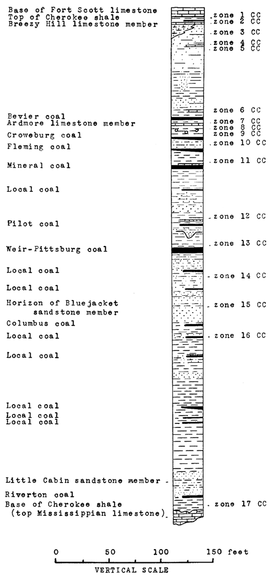
Collections from black shale 1 to 3 feet below top of Cherokee shale (fossil zone 1 CC)
Collections from fossil zone 1 CC occur in three types of lithology. Conodonts and Orbiculoidea missouriensis (Shumard) were obtained from black, fissile, "paper-thin" shales: O. missouriensis, from a large pyritic and calcareous black nodule about 15 inches in maximum diameter; and O. missouriensis, a larger species of Orbiculoidea, and fragments of fish bone from small phosphatic nodules about one inch in diameter. Three collections of plants were also obtained from this zone.
Collections from Breezy Hill limestone member (fossil zone 2 CC)
The Breezy Hill limestone is somewhat irregular in thickness and highly variable in lithology. The faunules are also variable. Gastropods are a relatively important element in some faunules. Other faunules are composed entirely of crinoid columnals and a few common species of brachiopods. All of them are marine. One collection is from a thin, light-gray, very sandy limestone or calcareous sandstone; two are from slightly sandy, reddish-brown to brownish-gray, medium to finely crystalline limestones; and the remaining collections are from argillaceous, very finely crystalline to dense, medium- to dark-neutral-gray limestones, which weather to a light yellow brown. One collection consisted entirely of fusulinids.
Collections from shales 2 to 10 feet below the Breezy Hill limestone member (fossil zone 3 CC)
A light tan-gray shale zone about 6 feet below the Breezy Hill limestone is very fossiliferous, and a large and varied faunule consisting of 8 or 10 species of brachiopods and of pelecypods, gastropods and cephalopods was obtained from it. A dark-brown to chocolate shale which occurs at about the same horizon, but at a different locality from the above collection has a faunule of pelecypods and gastropods but lacks the brachiopods so conspicuous in the faunules in the tan-gray shale.
Collections from local limestone 20 to 25 feet below the top of the Cherokee shale (fossil zone 4 CC)
Four collections were made from a local limestone 20 to 25 feet below the top of the Cherokee. They all came from an area northwest of Cherokee less than a mile across. The outstanding characteristic of the faunules is the overwhelming abundance of one species, "Productus" (Dictyoclostus) portlockianus Norwood and Pratten. The limestone is about 14 inches thick and in places is almost a coquina of this one species.
Collections from shale 28 feet below, top of Cherokee and 3 feet below limestone of zone 4 CC (fossil zone 5 CC)
A gray micaceous shale 3 feet below the limestone of zone 4 CC contains a rather large and varied faunule. The brachiopod, Marginifera muricatina Dunbar and Condra, is very abundant and individuals of it outnumber those of all other species combined. Collections were obtained from only one locality.
Collections from shales and thin limestones less than 6 feet above Bevier coal (fossil zone 6 CC)
Fossil zone 6 CC includes three or four thin limestones which are separated by thin shales. Collections were made both from the limestones and the shales. Three of the four collections are from black limestones--two from a 3- or 4-inch black finely crystalline very clayey limestone immediately above the Bevier coal, and one from a finely crystalline black or dark-brown, slightly ferruginous, somewhat clayey limestone about 6 feet above it. The limestone at each of these localities has white calcite "threads," some of which are probably fillings in Serpulopsis excavations. The limestone immediately on the Bevier coal has a rather large fauna, chiefly of brachiopods, of which Chonetes (Mesolobus) mesolobus Norwood and Pratten and Marginifera muricatina Dunbar and Condra are the most abundant. The limestone 6 feet above the Bevier is not very fossiliferous and except for the Serpulopsis, our collection from it has only some small brachiopods, most of which are of Crurithyris planoconvexa (Shumard). The prevalence of small individuals in the collection suggests a depauperate fauna.
Only one collection was made from the shales between the limestones. It contains only a few long-ranging species.
Collections from the Ardmore limestone member (fossil zone 7 CC)
The Ardmore limestone member is one of the most persistent and most fossiliferous limestones in the Cherokee. The lithology varies only slightly from place to place and at most localities from which collections were made it is a single bed of dark neutral to brownish-gray, finely crystalline to dense, argillaceous limestone. In many places this limestone is characteristically mottled light and medium neutral to blue-gray. It commonly weathers light yellow-brown, and in many places the limestone is covered by a weathered zone of one-fourth to an inch of light-yellow, very ferruginous clay.
Although fossils are abundant, they are difficult to obtain in identifiable condition. The largest collections were secured by "breaking away" the weathered surface zones or by collecting weathered-out specimens on the slopes slightly below the limestone. With few exceptions, the faunules consist almost entirely of brachiopods, of which Marginifera muricatina, Chonetes (Mesolobus) mesolobus, "Productus" (Dictyoclostus) portlockianus and spirifers are most characteristic. Marginifera wabashensis (Norwood and Pratten) is very common at some localities; Prismapora triangulata (White) occurs at three localities; and Trachydoma "wheeleri" (Swallow) is found at at least one locality. The occurrence of forms tentatively identified as Marginifera splendens? (Norwood and Pratten) and "Productus" (Dictyoclostus) americanus? (Dunbar and Condra) is interesting and if additional and more nearly complete specimens confirm the identifications, represents extension of the commonly quoted ranges of these species. Another interesting occurrence is that of a variety of Spirifer (Neospirifer) cameratus Morton that is gradational toward S. gorei Mather.
Collections from black shales less than 6 feet below the Ardmore limestone member (fossil zone 8 CC)
Four types of lithology are represented in the collections from the black shale zone between the Ardmore limestone and the Croweburg coal. In this respect and in the details of the lithology, these collections resemble those from fossil zone 1 CC--the black shale zone 1 to 3 feet below base of the Fort Scott limestone. Collections from black "paper-thin" shales contain little other than conodonts. Collections from small black flattened-subspheroidal phosphatic nodules at two localities, one of which is in Vernon County, Missouri, contain many small coiled cephalopods, most of which are not even generically determinate either because of poor preservation or extremely small size, which may indicate youth. Such cephalopods also occur in phosphatic nodules in zone 1 CC, but they are much more abundant in collections from zone 8 CC. In addition, these phosphatic nodules in zone 3 CC also contain fish teeth and pieces of fish bone and a few have Orbiculoidea missouriensis (Shumard). Collections from large black calcareous concretions contain lingulas, marginiferas and other brachiopods, and pelecypods and cephalopods. The latter two classes are represented mainly by indeterminate individuals, but additional detailed work may furnish some identifications. A single collection from a medium neutral gray clayey shale less than 1 foot below the base of the Ardmore and higher stratigraphically than most of the other collections from this zone contains several Marginifera muricatina Dunbar and Condra and other brachiopods and some pelecypods. This collection suggests that these beds may be the ones from which came two collections that were made from float, but without much doubt came from between the Ardmore limestone and Croweburg coal. If they did come from these beds, the fauna contains several pelecypods, small gastropods, and small orthoceroids not present in the collection from the shale in place.
Collections from shales a few inches to 4 feet above the Croweburg coal (fossil zone 9 CC)
The 3 to 8 feet of light neutral to light lead-gray shale immediately above the Croweburg coal is unfossiliferous at many localities, especially in the northern part of the area. One small collection made from these shales contained several individuals of Aviculipecten whitei Meek and some plant impressions. Another collection from within a few feet of the top of the Croweburg coal, was made from a brownish-gray shale and from ironstone "layers" within the shale. It contained six species of brachiopods and two or three species of gastropods.
Collections from shales a few inches to 2 feet above the Fleming coal (fossil zone 10 CC)
Two types of lithology are represented in the collections from the shale above the Fleming coal. A brownish-gray ferruginous shale, about 1 foot above the coal, contains a large brachiopod fauna. Black, calcareous, and in places pyritic shales almost on the coal are at some localities almost a coquina of fragmentary "Productus" (Dictyoclostus) portlockianus Norwood and Pratten. At one locality, these calcareous shales yielded a small collection of brachiopods and gastropods.
Collections from thin black limestones above Mineral coal (fossil zone 11 CC)
The thin, black, clayey, lenticular limestones and the calcareous shales immediately above the Mineral coal constitute one of the most fossiliferous zones in the Cherokee formation. This zone is characterized by a variety as well as an abundance of fossils. Especially abundant and more or less distinctive because of their abundance are spirifers, linoproductids, chonetids, and Marginifera muricatinas. The abundance of these forms, when combined with the lithology and the variety of organisms represented, makes this a zone that is recognizable at least locally, and may be distinguished from other zones of similar lithology. In addition to the abundant brachiopods, fusulinids are abundant at some localities; crinoid columnals are common at most localities; and corals, bryozoans, pelecypods, cephalopods, and trilobites are occasionally found. Brachiopods do, however, form the preponderant element in nearly all collections.
Collections from thin limestones, ironstones, and shales above but within 2 feet of Pilot coal (fossil zone 12 CC)
Thin limestones and calcareous ironstones occur in the interval from 0 to 2 feet above the Pilot coal. These beds are separated from the coal and from each other by thin shales. Where collections were made, the ironstones occur above the fossil-yielding limestones and shales. Collections from the ironstones and ferruginous limestones and limy shales are preserved in yellow-brown or reddish-brown matrices. Many of the shells are crushed and hence unidentifiable. Although outnumbered by brachiopods, fragments and molds of small gastropods are common and because they are not very common at other localities, they are here conspicuous. Pelecypod fragments are also common. Incomplete small and large cephalopods occur at one locality. Collections from "paper-thin" shales above the coal contain only conodonts, but where the shales are not so thinly bedded and are in part calcareous, lingulas, orbiculoideas, chonetids and other brachiopods, and occasional fragmentary pelecypods, gastropods and cephalopods occur.
Collections from shales immediately above Weir-Pittsburg coal (fossil zone 13 CC)
Normally the gray, finely laminated shale above the Weir-Pittsburg coal is not fossiliferous. Locally, in northern Cherokee County, black, carbonaceous, "coaly" shale immediately above and almost gradational into the Weir-Pittsburg coal contains a marine fauna of corals, crinoids, bryozoans, brachiopods, and pelecypods. Brachiopods are by far the most abundant in individuals and in species. The soft crumbly character of the shales made it impossible to transport many fossils under conditions which would allow them to be identified in the laboratory, and some of the identifications listed from this zone were made in the field. Field identifications are listed separately from laboratory identifications in the tables.
Collections from a limestone about 25 feet below the Weir-Pittsburg coal (fossil zone 14 CC)
Two collections, each containing three or four species of brachiopods and little else, were made from thin local limestone beds about 25 feet below the Weir-Pittsburg coal. One collection came from a medium neutral gray, fine-grained to dense limestone that weathers yellow brown. The other is from a thin, fine-grained, brownish-red clayey limestone.
Collections from Bluejacket sandstone member (fossil zone 15 CC)
Collections from the Bluejacket sandstone member are from light-yellow, very ferruginous, noncalcareous, 2- to 4-inch claystones. Although the collections are mostly of brachiopods, pelecypods and internal molds of gastropods are common. The brachiopods are mostly derbyas, chonetids, linoproductids, and marginiferas. The occurrence of Marginifera muricatina missouriensis? Girty is of stratigraphic interest.
Collections between the Bluejacket and Little Cabin sandstone members (fossil zone 16 CC)
Four collections of invertebrates and one of plants were obtained from the strata between the Bluejacket and Little Cabin sandstone members. The collection from the highest stratigraphic position came from the "cap rock" of a coal (Columbus?) about 10 feet below the base of the Bluejacket sandstone. It contains three species--a coral, a crinoid represented by columnals, and a brachiopod. These species are preserved in a dark-gray to almost black calcareous shale which also contains rock fragments about 2 or 3 millimeters in diameter. The rock fragments are presumably from reworked Cherokee beds and suggest that the fossils also may have been transported, but there is no other evidence to substantiate such a conclusion. The plant collection came from about the same stratigraphic position.
Two invertebrate collections came from an impure, lenticular, medium to lightly darker than medium neutral gray clayey limestone. It is 20 to 25 feet below the base of the Bluejacket sandstone, and therefore from approximately the same horizon as the Elm Creek limestone of Weidman (1932) in northeastern Oklahoma. This limestone weathers light brownish-gray, and its weathered surface is shaly. Fossil fragments are abundant on the weathered surface. Most of the fossils are brachiopods, but two bryozoans, two pelecypods and a cephalopod Pseudorthoceras knoxense (McChesney) have been identified in the collection. Individuals of Derbya, of Punctospirifer and of a species identified as Spirifer cf. S. occidentalis Girty are common. Large compositas are also common.
A 2- or 3-inch brownish to "hematite" red, ferruginous, and calcareous shale, which is about 50 feet below the base of the Bluejacket sandstone, contains many imperfect molds and casts of small pelecypods and gastropods. Many of these are coated with white calcite or very light-yellow limonite coatings.
Collection below Little Cabin sandstone member (fossil zone 17 CC)
Fossil zone 17 CC is the lowest zone from which invertebrate fossils were collected from Cherokee or Crawford counties. The one collection made from it was from a mine shaft. That collection came from 5 to 10 feet above the base of the Cherokee formation, 11 miles south and 1 mile west of Columbus, and contains both invertebrates and plants. The only invertebrate species was identified as Aviculipecten sp. undet.
Collections from the Cherokee shale of eastern Labette County
The zones or beds from which fossils were obtained in the Cherokee shale of eastern and southeastern Labette County are described in stratigraphic order below. They are also shown graphically in figure 13. The letters CL after the numbers refer to Cherokee shale of Labette County.
Figure 13--Generalized columnar section of the Cherokee shale of Labette County, Kansas (after W. G. Pierce), showing positions of fossil zones. (CL is abbreviation for Cherokee shale of Labette County.)
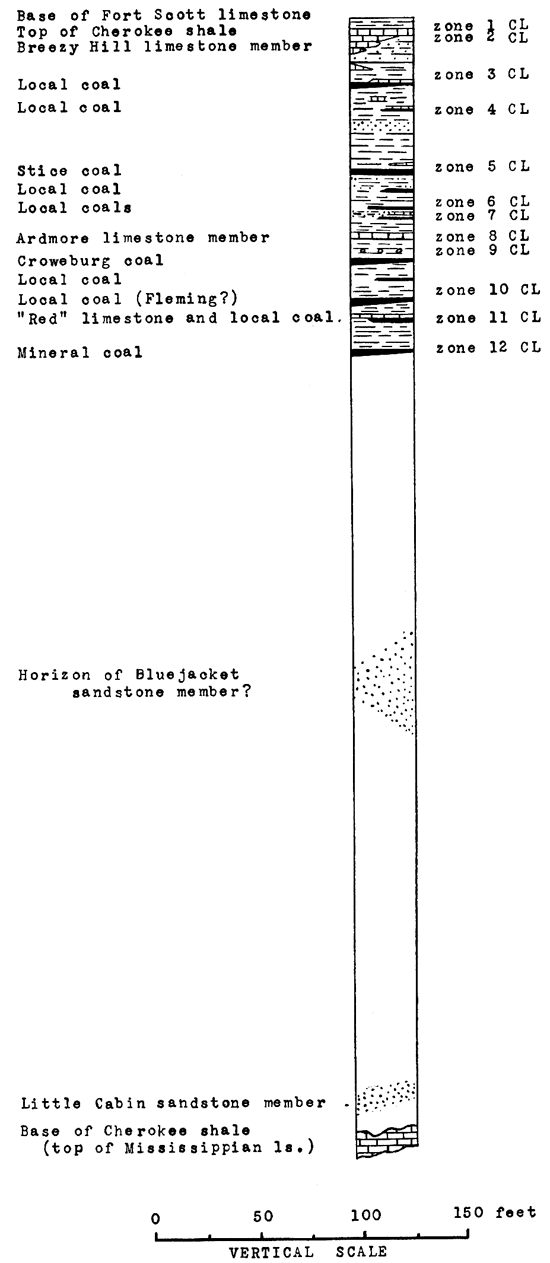
Collections from black shale 1 to 3 feet below top of Cherokee shale (fossil zone 1 CL)
Two types of lithology are represented in collections from the black shale 1 to 3 feet below the base of the Fort Scott limestone in Labette County. Black "paper-thin" shales yield conodonts and Aviculipecten rectilaterarius (Cox). Small phosphatic nodules about one inch in maximum diameter contain many individuals of Orbiculoidea missouriensis (Shumard), some pieces of fish bone and fish teeth, and rarely a small coiled cephalopod. No collections were made from the large black, dense, calcareous, and pyritic concretions such as yielded collections from this zone in Crawford and Cherokee counties.
Collections from Breezy Hill limestone member (fossil zone 2 CL)
The Breezy Hill limestone is even more variable in lithology and faunules in Labette County than in Crawford and Cherokee counties. At one locality the faunule consists mostly of medium-sized bellerophons or of bellerophontype gastropods and the lithology is a medium neutral gray, finely granular, sandy and clayey limestone, which weathers to a light gray. The grains are about one-third millimeter in diameter.
At some other localities the Breezy Hill is a light brownish-gray or light-tan, finely granular, slightly friable, silty limestone. At still others, it is a tan or deeper brown, ferruginous, and slightly calcareous sandstone. The faunules seen at localities of both of these types of rock are predominately of brachiopods. At some localities where the rock is more silty than sandy Squamularia is abundant. "Productus" (Linoproductus) insinuatus Girty occurs at one such locality, but it may be from float rather than in place. The same variety of Spirifer matheri Dunbar and Condra that occurs in some Breezy Hill collections from Crawford and Cherokee counties occurs at two Breezy Hill localities in Labette County.
Collections from shale about 30 feet below top of Cherokee (fossil zone 3 CL)
Tan and yellow-gray, laminated shale about 30 feet below the top of the Cherokee shale and a few feet above a coal is characterized by the occurrence together of plants and invertebrates. Although many invertebrate fossils are present only one or two species seem to be represented. By far the greater number of individuals probably belong to Aviculipecten rectilaterarius (Cox). A pelecypod that is probably an Edmondia occurs in one of the collections.
Collections from a limestone 40 to 45 feet below top of Cherokee shale and above a local coal (fossil zone 4 CL)
Collections were made from two uncorrelated local limestones 40 to 45 feet below the top of the Cherokee shale. One collection came from a dark-gray to black, very fossiliferous limestone overlying a local coal in an old strip pit. The other came from within a few hundred feet of the first collection but outside the strip pit. The lithology is a tan, finely granular, silty limestone. Both collections are largely of species of brachiopods that have long ranges in lower Pennsylvanian rocks. One species each of corals, crinoids, and bryozoans is represented.
Collections from this shaly limestone above Stice coal and about 70 feet below top of Cherokee (fossil zone 5 CL)
Fossils are abundant at three or four localities in a thin, black, shaly limestone overlying the Stice coal. In one place this limestone is almost a coquina of marginiferas and occasional other brachiopods. Among the more common elements in the faunules are, in addition to the marginiferas, chonetids of the mesolobus type, Spirifer cameratus, hustedias, wellerellas, and compositids. A few gastropods and an occasional orthoceraconic cephalopod are found in the faunules.
Collections from sandstone between Stice coal and Ardmore limestone (fossil zone 6 CL)
A tan to steel-gray, medium-grained, friable, micaceous sandstone, which occurs between the Stice coal and the Ardmore limestone, contains fossil plants at some localities and at others fossil invertebrates. The invertebrates are preserved mainly as external molds and it is difficult to tell whether or not the shells had been worn before being enclosed in the sandstone matrix. The well-preserved impressions of rather long spines suggests, however, that they had not been eroded. The only common form is the brachiopod "Productus" (Linoproductus) prattenianus Norwood and Pratten. Three pelecypod species and another brachiopod, an Orbiculoidea, also were obtained from this sandstone.
Collections from shales and thin limestones directly on a local coal about 95 feet below top of the Cherokee (fossil zone 7 CL)
Two collections that may not be from precisely the same stratigraphic positions were made from this zone in Labette County. One, from a hard, black, but slightly calcareous shale, contains plant impressions, two indeterminate brachiopods and Aviculipecten rectilaterarius (Cox). The other, whose stratigraphic relations are not surely known, contains seven species of brachiopods that are common in the Cherokee shale. The specimens appear to be from a weathered slope and the label is not clear regarding their precise relation to the coal.
Collections from the Ardmore limestone member, including some collections of uncertain position (fossil zone 8 CL)
Collections definitely from the Ardmore limestone came either from tan limestones or from dark to medium neutral gray, fine-grained, silty limestones that weather tan. The faunules are almost entirely of brachiopods, and in this respect resemble those of the Ardmore of the more northeasterly outcrops. Among the more abundant brachiopods are Chonetes (Mesolobus) mesolobus and its variety decipiens, Marginifera muricatina, Marginifera wabashensis, "Productus," including "Productus" (Linoproductus) prattenianus Norwood and Pratten and "Productus" (Juresania) nebrascensis Owen, and Squamularia perplexa (McChesney). Bryozoans are not uncommon. A Naticopsis? occurs in one of the collections and other gastropods occur in other collections; and indeterminate specimens of Gastrioceras occur in two collections.
Collections from gray and black shales 1 to 3 feet below the Ardmore limestone member (fossil zone 9 CL)
Two collections from the zone 1 to 3 feet below the Ardmore limestone came from two different types of rock that occupy slightly different stratigraphic positions. A small collection of three species of brachiopods, each represented by a single individual, came from a dark to medium neutral gray shale immediately below the Ardmore limestone. The other collection was obtained by splitting small, black subspheroidal phosphatic nodules which occur in the black shale. These nodules yielded a relatively large number of small, imperfect, coiled cephalopods and one specimen of Orbiculoidea missouriensis (Shumard).
Collections from fossiliferous black calcareous shale above coal bed, about 22 feet below Ardmore(?) limestone (fossil zone 10 CL)
A single collection came from a "black, tough, calcareous and pyritic shale overlying a 9-inch local coal bed." This shale is similar in character to the black shale immediately overlying the Fleming coal in parts of Crawford and Cherokee counties. The fossils from both shales are largely brachiopods; the collection from Labette County contains a greater variety than that from Crawford County.
Collections from "red" limestone, 16 to 18 feet above the Mineral coal (fossil zone 11 CL)
Two large and varied collections came from a yellowish-gray shaly zone about the horizon of the base of a limestone 16 to 18 feet above the Mineral coal. This limestone is red or reddish-gray at some localities and for that reason was called the "red" limestone. These collections evidently were from weathered slopes. Brachiopod species comprise about half those in the collections, but five or six species of small gastropods also occur in them. Pseudorthoceras knoxense (McChesney) occurs in both collections.
Collections from black calcareous shale or limestone immediately above Mineral coal (fossil zone 12 CL)
A black calcareous shale that occurs immediately above the Mineral coal has a fauna chiefly of brachiopods, in which productids, chonetids, spirifers, marginiferas, and compositids are most common. Fusulinids occur in one collection and a few gastropods occur in two collections.
Comparison of Faunal Zones and Ranges of Some Species within the Cherokee Shale
The study of the collections from the Cherokee shale has shown that there are in the Cherokee certain broad zones that can be recognized because they lack or contain fossils that other zones do or do not have. Small zones within these broad zones can be recognized, if one considers the relative abundance of fossils, or of certain species, together with the lithologic character of the beds and their position in the lithologic sequence. This type of evidence, it seems, should be trustworthy for small areas, within a single coal basin. Stratigraphic work in Crawford and Cherokee counties indicates that it is trustworthy.
Beds in an upper zone in the Cherokee shale extending down to the base of the Ardmore limestone can be distinguished from beds in lower zones by the occurrence of Prismopora triangulata, Chaetetes milleporaceus, and "Productus" (Linoproductus) insinuatus, in the upper beds. All three of these species are rare in this zone, however, and are more characteristic, at least in this part of Kansas, of the Fort Scott limestones. Serpulopsis insita is another species which ranges but a short distance below the Ardmore. On the other hand, Marginifera muricatina missouriensis and Spirifer occidentalis are more characteristic, if not actually restricted in this part of southeastern Kansas to beds below the Ardmore. Large cephalopods seem also to be more common in the lower part of the Cherokee in southeastern Kansas. Spirifer matheri occurs only in our Breezy Hill collections and comes from both the Crawford-Cherokee County and Labette County areas. Marginifera wabashensis was collected only from the Ardmore limestone and occurs in it in both areas. The significance of the restricted ranges of these two forms and of Spirifer occidentalis in our collections cannot, however, be considered great, as they have wider ranges elsewhere.
Three or four of the thinner zones of the Cherokee are very distinctive in Cherokee and Crawford counties. One of the most distinctive is a very fossiliferous zone in a black calcareous shale or limestone that occurs above the Mineral coal. At nearly every locality from which collections were made from this zone in Crawford and Cherokee counties, a large and varied fauna was obtained. This zone is characterized by its abundance of fossils, by its relatively large number of Spirifer cameratus, "Productus" (Linoproductus) prattenianus, and Marginifera muricatina and by the great numbers and several varieties of chonetids. Fusulinids are abundant at many localities. The fusulinids and chonetids in this zone locally distinguish it from our collections from a somewhat similar zone above the Bevier coal. The zone above the Mineral coal also has several bryozoans and some pelecypods not collected from the zone above the Bevier coal and in addition, Spirifer occidentalis, a brachiopod not collected from as high as the Bevier coal during this study.
Another distinctive zone within the Cherokee in Crawford and Cherokee counties is a black shale zone between the Ardmore limestone and the Croweburg coal. This zone somewhat resembles a zone at the very top of the Cherokee, 1 to 3 feet below the Fort Scott limestone. Both contain black "paper-thin" shales, with small phosphatic nodules and large calcareous nodules. In the zone beneath the Ardmore, small cephalopods are very frequently found by splitting the small phosphatic nodules.
The Breezy Hill limestone is characterized by its variability in faunules as well as in lithology. At some localities, gastropods are abundant; at others, brachiopods are nearly the only fossils collected.
An unnamed limestone that is 25 feet below the Fort Scott and has a limited areal extent in the northeast corner of T. 31 S., R. 23 E., is characterized by an abundance of one species of productid, "Productus" (Dictyoclostus) portlockianus. All collections from it show an abundance of this species, and they are so abundant in at least two localities as to suggest the term, productid coquina. It is the only gray limestone bed seen in which this species is so abundant and may be easily distinguished locally.
A zone from a few inches to 2 feet above the Fleming coal may be easily distinguished at most localities from the zone above the Mineral coal, by the small variety of fossils occurring in it.
Zones below the Mineral coal are in general less fossiliferous than zones above it. A zone above the Pilot coal is characterized by thin ironstones and ferruginous limestones, containing a large proportion of small gastropods and some cephalopods. Trachydomas occur in at least two collections.
The characteristics of the other zones not specifically mentioned here have been given in the discussions of their faunas.
Comparison of Cherokee Faunal Zones in Labette County with Zones in Crawford and Cherokee Counties
As has been stated elsewhere in this paper, a considerable area of poor exposures and insufficient drill holes in the large Neosho River flat separates the Cherokee-Crawford County area of Cherokee shale outcrop from the Labette County area. Within this area, lithologic changes of considerable magnitude appear to have taken place, for many minor and some larger details of the stratigraphic sequence are found to be quite different in the two areas. These changes have been brought about by the advent of new coals and limestones in the section and by changes in the lithologic characters or thicknesses of other limestones, shales, and sandstones. As a result, certain zones which could be followed over large parts of Crawford and Cherokee counties are either absent or have lost their distinctive faunal and lithologic characters by which they were there identified. Other zones, however, can be recognized in Labette County.
Zone 1 CL, the black shale below the Fort Scott limestone in Labette County, has the same faunal and lithologic characters as zone 1 CC in the Cherokee-Crawford County area. Zone 2 CL, the Breezy Hill limestone, shows the same lithologic and faunal variety as in the more easterly counties, and has some faunules in which gastropods are striking and preponderant elements. Spirifer matheri occurs in both areas. This species was collected only from the Breezy Hill.
Zones 3 CL, 4 CL, 5 CL, and 6 CL cannot be identified with any of the zones collected from in the Crawford-Cherokee County area and zones 3 CC, 4 CC, 5 CC, cannot be said with any assurance to be the same as any zone in the Labette County section.
Zone 7 CL is represented by small collections. Most of the species in collections from it are also in collections from zone 6 CC, but the main reliance for their correlation rests on their relation to the Ardmore limestone.
The Ardmore limestone, zones 8 CL and 7 CC, has faunules that are in both areas, composed in the main of brachiopods. Many of the more commonly seen species are the same in both areas. The faunules are much more uniform than those of the Breezy Hill and less variation is therefore seen when the Ardmore is followed along the strike. No Ardmore faunule is composed almost entirely of gastropods as are some Breezy Hill faunules in each of the two areas. A considerable number of species are present in only one area, however. Marginifera wabashensis occurs in the Ardmore in both areas and was not collected during this investigation from any other Cherokee limestone. Its absence from collections from other limestones may, however, be owing to the accidents of collecting.
Zone 9 CL, black shale below the Ardmore limestone in Labette County, has the same general faunal character as zone 8 CC. It is distinguished in both areas from other black shales in the section by the relatively large number of small coiled cephalopods. Although not considered a positive or definitely proven criterion, this faunal peculiarity is significant when considered along with the stratigraphic sequence. In each area, lighter gray shales above the black shales and below the Ardmore limestone have yielded collections of brachiopods and other fossils.
Zone 10 CL is somewhat like zone 10 CC lithologically, but there is little paleontologic data to warrant more than a suggested correlation. Zone 11 CL appears not to be represented in beds collected from in the Crawford-Cherokee County area. Zone 12 CL has in general the same species and to a certain extent the same proportions of species as zone 11 CC, black calcareous shale or limestone above the Mineral coal. When the evidence from the stratigraphic sequence is also considered, there appears to be sufficient faunal data to allow their correlation. Zones 12 CC to 17 CC are thought to be older than the oldest zone from which fossils were obtained in Labette County.
Differences Between the Cherokee and Fort Scott Formations and Regional Correlation of the Cherokee
An inspection of the collections here studied if taken alone would suggest several faunal means of distinguishing the Fort Scott and the Cherokee limestones. Some of these are probably valid; others are shown to be invalid by the published findings of other paleontologists.
The following species in our Fort Scott collections do not occur in our Cherokee collections: Chaetetes milleporaceus, Cystodictya n. sp., Meekella striatocostata, Meekella striatocostata grandicosta, "Productus" (Echinoconchus) semipunctatus knighti, "Productus" (Krotovia?) sp. undescribed, and several pelecypod and gastropod species. The first and third have, however, been reported by Girty from the upper limestones of the Cherokee, and the fourth may occur in the Cherokee. Another species that might be significant is Prismopora triangulata. It occurs in only one of our collections from the Cherokee and is there rather doubtfully identified, but it is common in our Fort Scott collections. However, it also has been reported from the upper part of the Cherokee by Girty and hence cannot be used as a diagnostic form of the Fort Scott. "Productus" insinuatus has been considered as a Fort Scott or higher index fossil, but it was also found in one collection from the Breezy Hill limestone made by one of the field assistants.
Several species and varieties occur in the Cherokee collections that do not occur in the Fort Scott, but most of them are from beds low in the Cherokee. They include Rhombopora lepidodendroides n. var., Marginifera muricatina missouriensis, Spirifer matheri, Spirifer rockymontanus, and a number of pelecypods and gastropods. These appear to be valid fossils for distinguishing the lower limestones of the Cherokee from the Fort Scott, but only a few can be used in distinguishing high Cherokee limestones from the Fort Scott limestone.
Our collections suggest that in southeastern Kansas the most useful means of distinguishing the Fort Scott and upper limestones of the Cherokee are the greater abundance in the Fort Scott of Chaetetes milleporaceus, Prismopora triangulata, "Productus" insinuatus, and Chonetes (Mesolobus) mesolobus euampygus, and the greater abundance locally in the Cherokee of Chonetes (Mesolobus) mesolobus, Marginifera muricatina, and Marginifera wabashensis. Some more or less rare species, some of which have been discussed above, may be of use at times and when lower beds of the Cherokee are involved Marginifera muricatina missouriensis and certain spirifers that have been mentioned are useful. A number of rarer forms that can at times be used are mentioned by Beede and Rogers (1904).
Another and very useful means of distinguishing the Fort Scott from upper limestones of the Cherokee is found in the associations of the beds. Most upper Cherokee limestones are associated with beds of shale that are rather fossiliferous and are likely to contain considerable pelecypod and gastropod faunas, whereas the shales associated with Fort Scott limestones usually are not fossiliferous.
Cherokee limestones represented in our collections have larger pelecypod and gastropod faunas than Fort Scott limestones, at least at the localities from which the latter were collected and examined.
The Cherokee shale of southeastern Kansas contains essentially the same faunas as the Cherokee of southwestern Missouri (Hinds and Greene, 1915).
The correlation of various zones within the Cherokee with narrow zones in the Cherokee of other regions is hampered by the few collections referred to individual and definite zones within the Cherokee of other regions. When more detailed maps of small areas of the Cherokee are prepared and adequate collections are made from the various beds, such correlations may be possible.
Register of Collecting Localities
All the collections made from Pennsylvanian rocks in connection with this study are listed below in numerical order except for a few collections which were made primarily for fusulinids or plants. The numbers preceding the descriptions are locality numbers in the file of Carboniferous invertebrate fossil localities of the United States Geological Survey. Except for five stated exceptions, all of the collections are from Kansas. The names of the collectors and the dates of the collections are not given, but this and other information that may at times be useful, but is not ordinarily important to other geologists, may be had by writing the United States Geological Survey.
7744. Crawford County, 1/2 mile south, 2 miles east of Englevale. In SW SW sec. 21, T. 28 S., R. 25 E., on side of a small tributary to Cox Creek, which drains strip pit, at a point 50-100 feet south of where tributary emerges from pit, near south line of section 21. Cherokee shale, Ardmore limestone member; collection from loose blocks and from "Skinned off" areas of rock in place; the limestone here has a thick outer weathered zone of yellow-brown argillaceous limestone. (Fossil zone 7 CC.)
7745. Crawford County, 3 1/4 miles west of city limits of Pittsburg. In SW SE sec. 21, T. 30 S., R. 24 E., and along small stream to north of road between sections 21 and 28, about 200 feet north of road and about 200 to 500 feet west of where stream crosses road and about 1,000 feet west of southeast corner of section 21. Fossils collected from loose blocks of limestone. Cherokee shale, Ardmore limestone member; from dark bluish-gray, finely crystalline limestone which occurs above a shale with large calcareous nodules and which weathers yellow brown and slabby. (Fossil zone 7 CC.)
7746. Crawford County, 1 1/2 miles east of McCune. Along a stream 1,000 feet south and 1,700 feet east of northwest corner of sec. 15, T. 31 S., R. 22 E. Cherokee shale, Ardmore limestone member (lithology suggests this may have come from shale just above top of Ardmore limestone). (Fossil zone 7 CC.)
7748. Crawford County, 1 mile west of Mulberry. From a point in strip pit about 600 feet west and 200 feet south of northeast corner of sec. 3, T. 29 S., R. 25 E. Cherokee shale, Ardmore limestone member. (Fossil zone 7 CC.)
7749. Crawford County, about 1 mile north of Cherokee. In roadside ditch to north of road which is on south side of SE NW sec. 7, T. 31 S., R. 24 E., across road from and 150-200 feet east of east limits of a cemetery; to east of top of a hill. Cherokee shale, shale 2 to 6 1/2 feet below Breezy Hill limestone member. (Fossil zone 3 CC.)
7750. Cherokee County, 1 1/4 miles west and 1 mile north of Mineral. Along stream, about 1,700 feet east and 1,000 feet north of southwest corner of sec. 36, T. 31 S., R. 22 E. Cherokee shale, Ardmore limestone member. (Fossil zone 7 CC.)
7751. Cherokee County, 2 1/4 miles south and 3 miles west of Mineral. Along road at small creek, near center of east line of NE sec. 22, T. 32 S., R. 22 E. Cherokee shale, Ardmore limestone member; from slabs. (Fossil zone 7 CC.)
7752. Labette County, 1 1/2 miles south and 1/2 mile cast of southeast limits of Oswego. Road cut on quarter section line road, 100 feet south of a concrete bridge in sec. 27, T. 33 S., R. 21 E. Cherokee shale, Ardmore limestone member?; from limestone and shales below. (Fossil zone 7 CC.)
7753. Crawford County, same locality as 7744. Cherokee shale, from thin black limestone within 4 or 5 feet above Bevier coal. (Fossil zone 6 CC.)
7754. Crawford County, same locality as 7744, except in strip pit about an eighth of a mile north of 7744 and about 50 feet east of road on west line of section 21. Cherokee shale, from 3 to 4 inch black fine-grained clayey limestone with white calcite "threads," within 4 or 5 feet above Bevier coal. (Fossil zone 6 CC.)
7755. Cherokee County, 2 miles west and 1 1/2 miles north of Mineral. In strip pit, 500 feet north and 1,300 feet west of southeast corner of sec. 26, T. 31 S., R. 22 E. Cherokee shale, shale about 8 feet above Ardmore limestone member. (Fossil zone 6 CC.)
7756. Crawford County, same locality and horizon as 7749.
7757. Crawford County, same locality as 7759. Cherokee shale, gray micaceous shale 3 feet below local limestone. (Fossil zone 5 CC.)
7758. Labette County, just east of Oswego, NW NW sec. 15, T. 33 S., R. 21 E., about 1,200 feet east of a bridge over Neosho River and on south side of river and 5 feet above water. Cherokee shale, hard, black shale above a local coal and about 95 feet below top of formation. (Fossil zone 7 CL.)
7759. Crawford County, 2 miles north and 1 mile west of Cherokee. On road along west line of sec. 1, T. 31 S., R. 23 E. Four tenths of a mile north of southwest corner of said section and 50 feet south of south end of first bridge one meets in going north from southwest corner of sec. 1. Cherokee shale, local limestone 20 to 25 feet below base of Fort Scott limestone, 14-inch medium dark neutral gray, finely crystalline to dense limestone which weathers yellow-brown and is almost a coquina of productid shells. (Fossil zone 4 CC.)
7760. Crawford County, same locality and horizon as 7749 and 7756.
7761. Crawford County, about 2 miles south and 1 1/4 miles east of Girard. On north line of sec. 5, T. 30 S., R. 24 E.; in pasture along small stream east and about 100 feet south of where stream crosses road which runs along north line of section. Locality is about one-fifth of a mile east of the northwest corner of section 5. Cherokee shale, Breezy Hill limestone member. (Fossil zone 2 CC.)
7762. Crawford County, same locality as 7749, except a few hundred feet west of 7749 and nearer to but still east of top of a hill; opposite and a few feet east of east limits of a cemetery. Cherokee shale, Breezy Hill limestone member; very finely crystalline to dense, dark neutral gray limestone that weathers light yellow-brown. (Fossil zone 2 CC.)
7763. Crawford County, 1 mile east of Arma. On south line sec. 4, T. 29 S., R. 25 E., about 2,300 feet west of southeast corner of section. North side of road in cut below crest of hill. Cherokee shale, Breezy Hill limestone member; from a thin, sandy limestone. (Fossil zone 2 CC.)
7764. Crawford County, 1 mile north of Englevale. In southeast corner SW NE sec. 13, T. 28 S., R. 24 E. In field along creek east of a point on railroad midway between first cut north of south line of section 13 and next cut north; and north of small trestle where this creek crosses railroad and about 100 to 150 feet east of railroad, on west bank of stream. Cherokee shale, Breezy Hill limestone member; from a sandy, reddish-brown to brownish-gray, medium to finely crystalline limestone. (Fossil zone 2 CC.)
7765. Labette County, about 3 miles east and half a mile south of Bartlett. In ditch to south of road, about 300 feet west of northeast corner of sec. 36, T. 34 S., R. 20 E., and about halfway down a hill and below a black shale. Cherokee shale, Breezy Hill limestone member. (Fossil zone 2 CL.)
7766. Labette County, 1 1/2 miles south and half a mile east of Oswego. In road cut near center of section and 100 feet south of a concrete bridge in sec. 27, T. 33 S., R. 21 E. Cherokee shale, shale about horizon of a local coal and about 95 feet below top of formation. (Fossil zone 7 CL.)
7767. Labette County, about 1 mile south of Oswego, from north end of a strip pit and about 1,800 feet south and 300 feet east of northwest corner of sec. 27, T. 33 S., R. 21 E. Cherokee shale, thin limestone overlying Stice coal. (Fossil zone 5 CL.)
7768. Crawford County, 2 miles south and half a mile west of Mulberry. On south line of sec. 11, T. 29 S., R. 25 E., about 2,000 feet west of southeast corner of section 11. Cherokee shale, Breezy Hill limestone member; argillaceous fine-grained limestone. (Fossil zone 2 CC.)
7769. Crawford County, same locality and horizon as 7762.
7770. Labette County, same locality and horizon as 7765.
7771. Labette County, same locality and horizon as 7767.
7772. Crawford County 1 1/2 miles north and 2 miles west of Cherokee. Along road on south line of SE SW SW sec. 2, T. 31 S., R. 23 E., where creek intersects road. Cherokee shale, local limestone 20 to 25 feet below top. (Fossil zone 4 CC.)
7773. Same locality and horizon as 7772.
7774. Cherokee county, 2 miles north of Mineral. On road on east line of sec. 30, T. 31 S., R. 23 E., about three tenths of a mile north of southeast corner section 30. Cherokee shale, small phosphatic nodules in black shale 1 to 3 feet below top. (Fossil zone 1 CC.)
7775. Labette County, just north of Oswego, in road cut about 900 feet along road southwest of a bridge over Neosho River and in SE NE sec. 16, T. 33 S., R. 21 E. Cherokee shale, black shale 1 to 3 feet below top; from small black phosphatic nodules. (Fossil zone 1 CL.)
7776. Labette County, same locality as 7765, but from higher zone. Cherokee shale, black shale 1 to 3 feet below top; from small black phosphatic nodules. (Fossil zone 1 CL.)
7777. Labette County, 5 1/2 miles north of north limits of Oswego. From water well a half mile east of a point on road at center of west line of NE sec. 21, T. 32 S., R. 21 E., and at farthest point north on creek. Cherokee shale, black "paper-thin" shale 1 to 3 feet below top. (Fossil zone 1 CL.)
7778. Crawford County, half a mile north of Englevale. From side ditch on north side of road along south line of sec. 13, T. 28 S., R. 24 E. First rise east of railroad and about 500 feet from southeast corner section 13. Cherokee shale, black fissile "paper-thin" shale 1 to 3 feet below top. (Fossil zone I CC.)
7779. Crawford County, 2 miles north and 1 mile east of Englevale. Ditch and old strip pit along west side of road on east line of sec. 7, T. 28 S., R. 25 E., about 1,200 feet north of southeast corner of section. Cherokee shale, from large black calcareous nodule in black shale 1 to 3 feet below top. (Fossil zone I CC.)
7780. Same locality as 7779. Fort Scott limestone, lower limestone member.
7781. Labette County, 2 1/2 miles north of northwest limits of Oswego in SE SE sec. 32, T. 32 S., R. 21 E. Cherokee shale, black shale 1 to 3 feet below top; from small phosphatic nodules in the black shale. (Fossil zone 1 CL.)
7782. Cherokee County, 2 miles west and 1 1/2 miles south of McCune. Along draw in SW sec. 24, T. 31 S., R. 21 E. Cherokee shale, small phosphatic nodules in black shale 1 to 3 feet below top. (Fossil zone 1 CC.)
7783. Crawford County, same locality as 7778. Fort Scott limestone, lower limestone member; limestone exposed beneath a sandstone and above a shale and coal.
7784. Cherokee County, 3 1/2 miles south and 1 3/4 miles west of McCune. Along road on west line sec. 31, T. 31 S., R. 22 E., about half a mile north of southwest corner of said section. From blocks piled out on road on top of hill; about 200 feet north of where red barn is across road from a house. Fort Scott limestone, lower limestone member; from float, but thought to be nearly in place.
7785. Same locality as 7761, except on side gullies to main creek and from 3 to 5 feet above stream. Fort Scott limestone, lower limestone member.
7786. Crawford County, half a mile north, quarter of a mile east of Englevale. Strip pit about 200 feet north of road along south side of sec. 18, T. 28 S., R. 25 E.; about 1,700 feet east and 200 feet north of southwest corner section 18, opposite a house and about in SE SW. Fort Scott limestone, lower limestone member.
7787. Crawford County, same locality and horizon as 7786.
7788. Labette County, half a mile north and a quarter of a mile east of Montana, sec. 4, T. 32 S., R. 21 E. Fort Scott limestone, 2 feet above base of lower limestone member.
7789. Crawford County, 4 miles north and 1 1/2 miles east of Englevale, from a small strip pit about 2,400 feet west and 1,800 feet north of southeast corner of sec. 32, T. 27 S., R. 25 E. Fort Scott limestone, lower 5 feet of lower limestone member.
7790. Crawford County, 3 1/4 miles north and 1 mile east of Englevale. In an abandoned strip pit mine 100 feet south of east-west road in NE NW NW sec. 5, T. 28 S., R. 25 E. Fort Scott limestone, basal 5 feet of lower limestone member.
7791. Labette County, same locality and horizon as 7788.
7792. Labette County, 1 1/2 miles south and 1 1/2 miles west of Bartlett. Along creek near center south line of sec. 32, T. 34 S., R. 20 E. Fort Scott limestone, upper limestone member.
7793. Crawford County, 1 1/4 miles west and half a mile north of Englevale. In pasture to north of and just across fence from (25 ft north of fence) road between secs. 14 and 23, T. 28 S., R. 24 E., 1,250 feet west of southeast corner of sec. 14, and about 50 yards east of 7794. Fort Scott limestone, upper limestone member; from a 3- to 6-inch bed of yellow-brown to olive, finely crystalline limestone at top of upper Fort Scott.
7794. Crawford County, 1 mile west and half a mile north of Englevale. In pasture along stream, just across fence south of road between sections 14 and 23, T. 28 S., R. 24 E. About 1,400 feet west of northeast corner of section 23. Fort Scott limestone, upper limestone member; from a light neutral to whitish-gray, finely crystalline limestone that weathers yellow brown.
7795. Crawford County, same locality as 7786. Fort Scott limestone, black shale about 30 inches below base of upper limestone member.
7796. Labette County, 1 1/2 miles north and 1 mile east of Bartlett. In southeast corner SE sec. 15, T. 34 S., R. 20 E. Fort Scott limestone, lower limestone member.
7797. Labette County, 6 miles north and 1 mile west of Montana. In NE sec. 7, T. 31 S., R. 21 E. (precise location uncertain). Labette shale, about 6 feet below top; from thin black limestone.
7798. Labette County, 6 miles north and 1 mile west of Montana. In SW SE NE sec. 7, T. 31 S., R. 21 E. Labette shale, about 7 feet below top; from a thin black limestone.
7799. Labette County, 1 3/4 miles west and half a mile south of Montana. Roadside ditch at southwest corner of road intersection and across road from northwest corner sec. 18, T. 32 S., R. 21 E. Top Labette shale; from phosphatic nodules from black shales.
7800. Labette County, 2 1/2 miles north and 2 miles west of Chetopa, along a draw about 2,400 feet east and 1,900 feet south of northwest corner of sec. 20, T. 34 S., R. 21 E. Cherokee shale, shale 1 to 3 feet below Ardmore limestone member. (Fossil zone 9 CL.)
7801. Labette County, 2 miles north and l 1/2 miles west of Chetopa, from strip pit along road and about 1,800 feet south of northwest corner of sec. 21, T. 34 S., R. 21 E. Cherokee shale, shale 1 to 3 feet below Ardmore limestone member; from small black phosphatic nodules. (Fossil zone 9 CL.)
7802. Crawford County, about 1 mile north and three quarters of a mile west of Mulberry. From a strip pit in NW SW sec. 26, T. 28 S., R. 25 E. Cherokee shale, cap limestone of Mineral coal; from a black shaly limestone. (Fossil zone 11 CC.)
7803. Crawford County, 1 mile north and 3 1/2 miles east of Englevale. From strip pit near center of sec. 15, T. 28 S., R. 25 E. Cherokee shale, cap limestone, of Mineral coal; from a very shaly black limestone or calcareous shale. (Fossil zone 11 CC.)
7804. Vernon County, Missouri, 1 mile north and three quarters of a mile east of Arcadia. From a strip pit about 3,000 feet west and 1,600 feet north of southeast comer of sec. 31, T. 34 S., R. 33 W. Cherokee shale, shale less than 6 feet below Ardmore limestone member; from small phosphatic nodules and large black calcareous nodules. (Fossil zone 8 CC.)
7805. Crawford County, half a mile south and 2 miles east of Englevale. Along Cox Creek, opposite where tributary that drains strip pit empties into Cox Creek, about in SW SW sec. 21, T. 28 S., R. 25 E. Cherokee shale, shale less than 6 feet below Ardmore limestone member; from a large calcareous concretion which had been removed a foot or so from where it probably came. (Fossil zone 8 CC.)
7806. Crawford County, 1 mile south and 2 1/2 miles east of Farlington, along road between secs. 16 and 21, T. 28 S., R. 24 E., on bank above roadside ditch to south of road, and just west of top of hill. About 2,000 feet west of northeast corner of section 21. Pawnee limestone.
7807. Labette County, 1 3/4 miles south and three quarters of a mile west of Montana. Along road on east side of sec. 19, T. 32 S., R. 21 E., about 2,400 feet south of northeast corner of section and in SE SE NE sec. 19. Labette shale; from 6-inch black limestone about 7 feet below top.
7808. Labette County, 5 miles north and a quarter of a mile west of Montana. In road cut in NE NW sec. 17, T. 31 S., R. 21 E. Lower part of Pawnee limestone.
7809. Crawford County, 2 miles west of Englevale. About a quarter of a mile due south of northeast corner sec. 22, T. 28 S., R. 24 E. Labette shale, about 22 feet below top; from a thin black limestone.
7810. Same locality and horizon as 7809.
7811. Cherokee County, 5 miles south and 3 1/2 miles west of Mineral. From an abandoned strip pit in SE sec. 34, T. 32 S., R. 22 E. and in field about 200 feet north of road on south line of section 34, about 800 feet west of southeast corner of section 34. Cherokee shale, shale less than 6 feet below Ardmore limestone member; fossils weathered out on dump, but thought to come from this horizon. (Fossil zone 8 CC.)
7812. Crawford County, 1 mile west of Mulberry. From east side of a strip pit, about 600 feet west and 200 to 800 feet south of northeast corner see. 3, T. 29 S., R. 25 E. Cherokee shale, shale a few inches to 4 feet above Croweburg coal; from a light neutral to light lead-gray shale. (Fossil zone 9 CC.)
7813. Crawford County, 4 miles north and 1 mile east of Englevale. Along east line of sec. 31, T. 27 S., R. 25 E., about 1,400 feet south of northeast corner of said section and on north side of a stream. Cherokee shale, gray shale about 1 foot below base of Ardmore limestone member. (Fossil zone 8 CC.)
7814. Cherokee County, same locality and horizon as 7811; also from weathered material on dump at old strip pit.
7815. Cherokee County, about 1 mile east of east limits of Cherokee. From a strip pit 50 to 60 feet south of east-west road on north line of sec. 20, T. 31 S., R. 24 E., and about one eighth of a mile west of northeast comer of section 20. Cherokee shale, shale above and within 18 inches of Fleming coal. (Fossil zone 10 CC.)
7816. Crawford County, 1 mile west of Mulberry. About 1,300 feet east and 600 feet north of southwest corner sec. 35, T. 28 S., R. 25 E. Cherokee shale, shale less than 6 feet below Ardmore limestone member; from small phosphatic nodules in black "paper-thin" shales and from shales themselves. (Fossil zone 8 CC.)
7817. Crawford County, three quarters of a mile south and 3 miles west of west limits of Pittsburg. From strip pit of Pittsburg-Midway Coal Company, about in center SW sec. 34, T. 30 S., R. 24 E. Cherokee shale, shale 1 to 10 inches above Fleming coal; from a pyritic and limy zone in black shale which is almost a coquina of productids. (Fossil zone 10 CC.)
7818. Crawford County, same locality and horizon as 7802.
7819. Crawford County, 2 1/2 miles north of Mulberry. From near center of NW sec. 24, T. 28 S., R. 25 E. Cherokee shale, shale about 1 foot above Fleming coal; from a sandy and limy zone in the shales. Has many macerated shells. (Fossil zone 10 CC.)
7820. Labette County, 4 miles north of Bartlett. From along a small draw near center of east line of NE sec. 4, T. 34 S., R. 20 E. Fort Scott limestone, upper limestone member; from a very light purplish limestone literally filled with shell fragments and spines, many of which are honey-yellow.
7821. Crawford County, half a mile south and 2 miles west of Arcadia. From a strip pit near center of SW sec. 3, T. 28 S., R. 25 E. Cherokee shale, cap limestone of Mineral coal. (Fossil zone 11 CC.)
7822. Labette County, 4 1/2 miles north, half a mile west of Bartlett. In quarry south of road at jog in road, about 1,700 feet west and 150 feet south of northeast comer of sec. 4, T. 34 S., R. 20 E. Fort Scott limestone, upper limestone member; from a purplish-gray finely crystalline limestone.
7823. Crawford County, about 2 1/2 miles west of Pittsburg. In SE SW SE sec. 22, T. 30 S., R. 24 E. About a third of a mile west of southeast corner of section 22, and less than 150 feet north of road between sections 22 and 27. Cherokee shale, cap limestone of Mineral coal; from a black, very shaly limestone a foot or so above the coal. (Fossil zone 11 CC.)
7824. Crawford county about 2 1/4 miles east and 5 1/4 miles north of Pittsburg. From strip pit in SW NW SW sec. 23, T. 29 S., R. 25 E., about a quarter of a mile north of southwest corner of section 23 and from 200 to 600 feet east of road along west section line. Cherokee shale, cap limestone of Mineral coal; from a 4- to 6-inch black shaly limestone or limy shale about 2 feet above coal. (Fossil zone 11 CC.)
7825. Crawford County, same locality as 7817, but from lower bed. Cherokee shale, cap limestone of Mineral coal; from a thin limy shale or limestone about 3 1/2 feet above coal. (Fossil zone 11 CC.)
7826. Cherokee County, 1 mile east and a half mile south of Mineral. From a strip pit of Pittsburg-Midway Coal Co. about an eighth of a mile east and half a mile south of the northwest corner of sec. 9, T. 32 S., R. 23 E., and about 300 feet east of a church. Cherokee shale, cap limestone of Mineral coal; from a 4- to 6-inch black shaly limestone represented by blocks which were loose but came from immediately above the coal. (Fossil zone 11 CC.)
7827. Cherokee County, same locality as 7815 but from lower beds. Cherokee shale, beds above Mineral coal; from a very limy black shale within a few inches of the top of the coal. (Fossil zone 11 CC.)
7828. Cherokee County, 3 miles south and 1 mile west of Mineral. Old abandoned pit in field 150 feet north of road on south side of sec. 24, T. 32 S., R. 22 E., and about half a mile east of southwest corner of section 24. About 75 feet west of a small stream which crosses road under a concrete culvert, which is the first concrete culvert from the southwest corner of section 24. Cherokee shale, cap limestone of Mineral coal; from a thin black limestone and limy shale zone a few inches above the coal. (Fossil zone 11 CC.)
7829. Crawford County, about 1 1/2 miles south of Arcadia. From along a small creek, 10 to 50 feet west of a bridge of poles and stones, and 90 feet south and 900 feet east of northwest corner of sec. 13, T. 28 S., R. 25 E. This is across road south of a mine dump and is about 3,000 feet west of Kansas-Missouri line. Cherokee shale, 3- to 4-inch limestone about 20 inches above Pilot coal; the limestone is 10 inches below a 1- to 2-inch ironstone bed. (Fossil zone 12 CC.)
7831. Cherokee County, 5 miles south of southeast limits of Pittsburg. Along south bank of Cow Creek, about 1,000 feet south and 100 feet east of northwest corner of sec. 28, T. 31 S., R. 25 E. Cherokee shale, limestone below Weir-Pittsburg coal; exact distance below coal unknown, but thought to be about 25 feet. (Fossil zone 14 CC.)
7832. Crawford County, same locality as 7829, but from black "paper-thin" shale below limestone that yielded collection 7829 and above Pilot coal. (Fossil zone 12 CC.)
7833. Cherokee County, in west edge of Scammon. On south bank of a stream and about 150 feet east of section-line road (Highway 7) about four tenths of a mile south of northwest corner of sec. 7, T. 32 S., R. 24 E. From bed of creek at point where stream turns from southward to westward to cross highway. Cherokee shale, shale less than two feet above Pilot (?) coal; from black calcareous shale below a 3- or 4-inch ferruginous limestone. (Fossil zone 12 CC.)
7834. Cherokee County, same locality and horizon as 7833.
7835. Cherokee County, same locality as 7833, but from a 3- to 4-inch bed of very ferruginous limestone a few inches above beds of 7833.
7836. Same locality and horizon as 7828.
7837. Barton County, Missouri, 2 1/2 miles east of Mulberry. Along south line SW SW sec. 4, T. 32 N., R. 33 W. Cherokee shale, limestone below Weir-Pittsburg coal; from a brownish-red limestone of unknown position, but thought to be 20 to 25 feet below coal. (Fossil zone 14 CC.)
7838. Barton County, Missouri, about 3 miles north of Minden. From strip pit about 400 feet east and 50 feet north of southwest corner of sec. 17, T. 32 N., R. 33 W., and across road and a little north and about 400 feet east of Fairview school Dist. No. 6. Cherokee shale, shale about 24 inches above Pilot coal; from a red very ferruginous 4- to 6-inch shale. (Fossil zone 12 CC.)
7839. Cherokee County, about 3 1/2 miles south and 1 mile east of Columbus, near northeast corner sec. 6, T. 34 S., R. 24 E. On rise across side ditch to west from road, within 10 to 15 feet of ditch, and about 75 yards west and then south of a railroad viaduct, which viaduct is just before road turns definitely south. Cherokee shale, from a thin brownish red ferruginous and calcareous shale or ironstone about 50 feet below Bluejacket sandstone member. (Fossil zone 16 CC.)
7840. Cherokee County, 11 miles south and 1 mile west of Columbus. From mine in sec. 10, T. 35 S., R. 23 E. Cherokee shale, basal beds, 5 to 10 feet above Mississippian limestone. (Fossil zone 17 CC.)
7841. Cherokee County, 5 miles south and 2 miles west of Columbus. Along stream in SW SE sec. 9, T. 34 S., R. 23 E. Cherokee shale, limestone 10 to 14 feet below Bluejacket sandstone member. (Fossil zone 16 CC.)
7842. Cherokee County, 4 miles south of Columbus. On west bank of a small stream on west side of old strip pit in SW SW sec. 6, T. 34 S., R. 24 E. Cherokee shale, 10- to 12-inch impure lenticular limestone 20 feet below Bluejacket sandstone member; approximately same stratigraphic horizon as the Elm Creek limestone of Weidman. (Fossil zone 16 CC.)
7843. Cherokee County, same locality and horizon as 7842.
7844. Cherokee County, about 7 miles south of east edge of Columbus. From east road ditch on Highway 7 a little over l00 feet north of center of west line of sec. 19, T. 34 S., R. 24 E. Cherokee shale, Bluejacket sandstone member; from 3- to 6-inch bed of noncalcareous ferruginous claystone. (Fossil zone 15 CC.)
7845. Cherokee County, due south of Columbus on highway 7. Definite locality not given on label, but thought to be same as 7844. Same horizon as 7844.
7846. Cherokee County, 1 3/4 miles south and 1 mile east of Scammon. From east side of a strip pit and about 1,700 feet west and 200 feet south of northeast corner of sec. 20, T. 32 S., R. 24 E. Cherokee shale, shale above Weir-Pittsburg coal; from soft crumbly carbonaceous shale which grades into the coal. (Fossil zone 13 CC.)
7846A. Same locality and horizon as 7846. Identifications made by J. S. Williams in the field.
7847. Same locality as 7819, but from lower beds. Cherokee shale, cap limestone of Mineral coal. (Fossil zone 11 CC.)
7848. Cherokee County, same locality and horizon as 7827; said to be from 3 feet above Mineral coal.
7849. Cherokee County, 4 1/2 miles south and 4 1/2 miles west of Mineral. In creek bed about 2,000 feet north of southwest corner of sec. 33, T. 32 S., R. 22 E. Cherokee shale, shale about 2 feet above Croweburg coal; from a brownish-gray shale and from ironstone bands within the shale. (Fossil zone 9 CC.)
7850. Vernon County, Missouri, same locality and horizon as 7804.
7851. Labette County, 1 mile north and 1 mile west of Chetopa. From strip pit in NW sec. 28, T. 34 S., R. 21 E., from about 1,800 feet east and 1,400 feet south of northwest corner of section 28. Cherokee shale, black limestone overlying Mineral? coal. (Fossil zone 12 CL.)
7852. Labette County, 2 miles north and 1 mile west of west city limits of Chetopa. From strip pit and about 2,000 feet south and 800 feet west of northeast corner of sec. 20, T. 34 S., R. 21 E. Cherokee shale, Ardmore limestone member(?); label reads "from Ardmore limestone and shale below." (Fossil zone 9 CL.)
7853. Labette County, 3 miles south and 1 mile east of Oswego. Along road about center of south line of SW SW sec. 35, T. 33 S., R. 21 E., and about 500 feet west of Neosho River. Cherokee shale, Ardmore limestone member. (Fossil zone 8 CL.)
7854. Cherokee County, 1 mile north and a quarter of a mile east of Cherokee. Along stream and about 1,400 feet south and 1,000 feet east of northwest corner of sec. 8, T. 31 S., R. 24 E. Cherokee shale, Ardmore limestone member. (Fossil zone 7 CC.)
7855. Labette County, 2 miles north and 1 mile west of Chetopa, about center of west line of sec. 21, T. 34 S., R. 21 E. Cherokee shale, Ardmore limestone member; from a dark-gray, very finely crystalline limestone. (Fossil zone 8 CL.)
7856. Crawford County, same locality and horizon as 7744.
7857. Crawford County, same locality and horizon as 7744.
7858. Labette County, 5 miles north of Chetopa. In NW NE SE sec. 3, T. 34 S., R. 21 E., and about 200 feet east of a north-south road. Cherokee shale, Ardmore limestone member. (Fossil zone 8 CL.)
7859. Labette County, 2 miles south and three quarters of a mile east of Oswego. About 1,000 feet cast and 400 feet south of center of north line of sec. 34, T. 33 S., R. 21 E. Cherokee shale, Ardmore limestone member. (Fossil zone 8 CL.)
7860. Labette County, same locality and horizon as 7853, but from float.
7861. Labette County, 1 1/2 miles west of Chetopa. Along an east-west flowing creek about 1,700 feet east of the west line of sec. 32, T. 34 S., R. 21 E., and in NE SW of said section. Cherokee shale, Ardmore limestone member. (Fossil zone 8 CL.)
7862. Labette County, 2 miles north and 2 miles west of Chetopa. Along a small draw in SW NE sec. 19, T. 34 S., R. 21 E. Cherokee shale, Ardmore limestone member. (Fossil zone 8 CL.)
7863. Labette County, 1 1/2 miles south and a quarter of a mile east of southeast limits of Oswego. In road 600 feet south of center of sec. 27, T. 33 S., R. 21 E. Cherokee shale, shale about horizon of Ardmore limestone member. (Fossil zone 8 CL.)
7864. Crawford County, same locality and horizon as 7744.
7865. Crawford County, 4 3/4 miles north of Englevale. Where road on east line of sec. 25, T. 27 S., R. 24 E., crosses creek, about 1,000 feet north of southeast corner of section. Cherokee shale, Ardmore limestone member. (Fossil zone 7 CC.)
7866. Crawford County, 3 miles due west of Cherokee. About 400 feet west of center of east line of sec. 16, T. 31 S., R. 23 E., and just south of a railroad trestle. Cherokee shale, Ardmore limestone member; from a calcareous conglomerate or lime-pellet bed. Fossils may be transported but are more probably indigenous. (Fossil zone 7 CC.)
7867. Crawford County, same locality as 7813. Cherokee shale, Ardmore limestone member. (Fossil zone 7 CC.)
7868. Crawford County, southwest edge of town of Mulberry. From strip pit 1,900 feet west and 600 feet north of center of sec. 1, T. 29 S., R. 25 E. Cherokee shale, from upper bed of a series of three or four limestones within 4 or 5 feet above Bevier coal; from fine-grained black limestone with white calcite "threads." (Fossil zone 6 CC.)
7869. Crawford County, 1 1/2 miles north and 2 miles west of Cherokee. At center of west line NW NW sec. 11, T. 31 S., R. 23 E. Cherokee shale, unnamed local limestone 25 feet below top. (Fossil zone 4 CC.)
7870. Cherokee County, 2 miles north of Mineral. At center of east line SE sec. 30, T. 31 S., R. 23 E. From ditch on west side of road. Cherokee shale, shale 2 to 6 1/2 feet below Breezy Hill limestone member. (Fossil zone 3 CC.)
7871. Labette County, 3 miles west of west limits of Chetopa. Railroad cut near east line of sec. 36, T. 34 S., R. 20 E., and about 1,800 feet north of southeast corner of section 36. Cherokee shale, Breezy Hill limestone member; from a very sandy but fine-textured limestone. (Fossil zone 2 CL.)
7872. Crawford County, same locality and horizon as 7762.
7873. Labette County, 3 miles west of west limits of Chetopa. On west line of sec. 31, T. 34 S., R. 21 E., about 2,200 feet south of northwest corner of section. Cherokee shale, Breezy Hill limestone member; from a coarse sandy limestone. (Fossil zone 2 CL.)
7874. Labette County, 1 mile south and half a mile cast of Bartlett. From near the southwest corner NE sec. 34, T. 34 S., R. 20 E. Fort Scott limestone, lower limestone member; from a single slab of rock.
7875. Labette County, half a mile north and 3 miles west of Chetopa. SW sec. 30, T.3 4 S., R. 21 E. Fort Scott limestone, lower limestone member.
7876. Labette County, half a mile north and 3 miles west of Chetopa. In SW sec. 30, T. 3 4 S., R. 21 E. Fort Scott limestone, lower limestone member.
7877. Labette County, 1 3/4 miles north and half a mile west of Bartlett. In bed of Dry creek near the west center of the SE sec. 16, T. 34 S., R. 20 E., and about 2,200 feet west and 1,200 feet north of the southeast comer of section 16. Fort Scott limestone, lower limestone member.
7878. Labette County, 1 1/2 miles east of Bartlett. NW NW SE sec. 26, T. 34 S., R. 20 E. Fort Scott limestone, lower limestone member.
7879. Labette County, in city park of Oswego overlooking Neosho River. NW sec. 15, T. 33 S., R. 21 E. Fort Scott limestone, lower limestone member; from a piece of light yellow-brown limestone float, taken from near lower limestone outcrops.
7880. Cherokee County, same locality and horizon as 7822.
7881. Labette County, half a mile north and 3 miles west of Chetopa. Along road on south line SW sec. 30, T. 34 S., R. 21 E., about 900 feet east of southwest comer of section. Fort Scott limestone, lower 2 feet of upper limestone member.
7883. Crawford County, 2 miles south and 4 miles west of Girard. Along north side of a draw about 700 feet west and 1,000 feet north of southeast corner of sec. 31, T. 29 S., R. 23 E. Fort Scott limestone, upper limestone member.
7884. Labette County, half a mile north and 1 1/4 miles west of Bartlett. On west side of creek near southeast corner sec. 20, T. 34 S., R. 20 E. Fort Scott limestone, upper limestone member.
7886. Crawford County, same locality and horizon as 7794.
7887. Labette County, 1 1/2 miles north and 1 1/4 miles west of Chetopa. From strip pit on east side of road about 700 feet south of northwest corner of sec. 28, T. 34 S., R. 21 E. (locality somewhat ambiguous on label). Cherokee shale, cap rock Mineral coal; from black limestone directly on coal. (Fossil zone 12 CL.)
7888. Labette County, 3 miles west of west limits of Chetopa. On north side of Missouri Pacific railroad. On center west line SW sec. 31, T. 34 S., R. 21 E. Cherokee shale, Breezy Hill limestone member?; about 15 feet below Fort Scott limestone. (Fossil zone 2 CL.)
7889. Labette County, 1 mile south and 2 miles west of southwest limits of Chetopa. In team strip pit, about 1,000 feet east of southwest corner of sec. 5, T. 35 S., R. 21 E., 40 feet north of road and 300 feet west of a draw. Cherokee shale, shale 30 feet below top; from a tan and yellow-gray laminated clay shale a few feet above a coal. (Fossil zone 3 CL.)
7890. Labette County, same locality and horizon as 7889.
7891. Labette County, same locality and horizon as 7889.
7892. Labette County, 3 miles south and a quarter of a mile east of southeast limits of Oswego. From a small strip pit about 1,500 feet east and 900 feet north of southwest corner of sec. 34, T. 33 S., R. 21 E. Cherokee shale, thin limestone above Stice coal. (Fossil zone 5 CL.)
7893. Labette County, 4 miles west of Chetopa. From strip mines north of railroad in NE SE sec. 35, T. 34 S., R. 20 E. Cherokee shale, thin black limestone above Stice coal. (Fossil zone 5 CL.)
7894. Labette County, 2 1/2 miles south and 3 miles west of southwest limits of Chetopa. In road ditch on Kansas-Oklahoma state line, 800 feet west of southeast comer sec. 13, T. 35 S., R. 20 E. Cherokee shale, limestone about 40 feet below top. (Fossil zone 4 CL.)
7895. Craig County, Oklahoma, same locality as 7894, except 500 feet southwest of 7894 and in Oklahoma rather than in Kansas. Cherokee shale, limestone 40 feet below top; from "a dark gray to black very fossiliferous limestone overlying coal in an old strip pit." (Fossil zone 4 CL.)
7896. Labette County, 5 miles north of Chetopa. From strip pit in northwest corner SW NW sec. 2, T. 34 S., R. 21 E. Cherokee shale, black calcareous shale immediately above a 9-inch coal bed and about 22 feet below Ardmore limestone member. (Fossil zone 10 CL.)
7897. Labette County, 1 1/2 miles north and 1 mile west of Chetopa. From strip pit to south of road and from 1,000 feet east of northwest corner of sec. 28, T. 34 S., R. 21 E. Cherokee shale, limestone about 16 feet above Mineral coal; probably from float from this limestone, which may be the "red" limestone. (Fossil zone 11 CL.)
7898. Labette County, 3 miles east and 1 mile north of Bartlett. About 2,200 feet south and 600 feet west of the northeast corner of sec. 24, T. 34 S., R. 20 E. Cherokee shale, sandstone between Stice coal and Ardmore limestone member. (Fossil zone 6 CL.)
7899. Labette County, 1 mile north of northwest limits of Chetopa. From small excavation in SW SE NW sec. 27, T. 34 S., R. 21 E. Cherokee shale, limestone above Mineral coal; "from black limestone on coal." (Fossil zone 12 CL.)
7900. Labette County, from same locality and horizon as 7871, but may be from float.
7901. Labette County, same locality and horizon as 7863.
7902. Labette County, same locality and horizon as 7863.
7903. Labette County, same locality and horizon as 7897.
7904. Labette County, 1 1/2 miles north and 3 miles west of Chetopa. From bed of creek, about 2,000 feet north and 400 feet east of southwest corner of sec. 19, T. 34 S., R. 21 E. Cherokee shale, sandstone about 15 feet above Ardmore limestone member. (Fossil zone 6 CL.)
7905. Same locality and horizon as 7811, but from large black calcareous nodules.
Prev Page--Mineral Resources || Next Page--References
Kansas Geological Survey, Geology
Placed on web July 27, 2011; originally published Sept. 1938.
Comments to webadmin@kgs.ku.edu
The URL for this page is http://www.kgs.ku.edu/Publications/Bulletins/24/07_fauna.html