![]()
Prev Page--Stratigraphy || Next Page--Mineral Resources
Structure
The geologic structure of the area treated in this report is shown by the contour map (Pl. 5). A preliminary edition of the map (Pierce and others, 1935) in practically its present form was published in 1935.
The description of the geologic structure is divided for convenience of description into two parts, one comprising the southeastern Kansas coal field and the other that part of the Tri-State zinc-lead district lying within the area described in this report. The structure contours are drawn on the Weir-Pittsburg coal or its equivalent horizon.
Structure of the southeastern Kansas coal field
The area here termed the southeastern Kansas coal field comprises all of the area of Plate 5, except the southeastern half of Cherokee County. It lies northwest of the Ozark uplift and, accordingly, the prevailing dip is to the northwest. The general direction of strike is northeast, but in detail it is usually either north or east. The change in trend from north to east, or even to southeast, is abrupt and when represented by contour lines forms a zigzag pattern.
(NOTE: Since this report was written a paper by Rich on the "Fault-block nature of Kansas structure suggested by elimination of regional dip," was published in Am. Assoc. Petroleum Geolgists Bull., October 1935. Time did not permit an analysis of the structure of this area is in a general way like that in the area discussed by Rich and should furnish interesting material for speculation if subjected to similar treatment.)
The most prominent structural feature is the Pittsburg anticline, which is here named from the town of Pittsburg in southeastern Crawford County. It has a maximum structural relief of about 70 feet and ranges in width from 4 miles in the southeastern part to 2 miles in the northwestern part. The anticline extends for an undetermined distance in Missouri. It enters Kansas near the southeast corner of T. 30 S., R. 25 E., trends northwestward to Capaldo, and then swings west-northwest to Girard. In T. 30 S., R. 25 E., the crest of the anticline plunges to the northwest, but beyond Capaldo it rises again and the anticline is a narrow, slightly domed fold which has a minimum closure of about 20 feet.
Closed depressions from 10 to 20 feet in depth are not uncommon in the area. These may be due in part to compaction phenomena. Others, however, are of much greater depth and are probably attributable to some other cause-perhaps to solution of the Mississippian limestone, with subsequent sinking of the overlying Cherokee shale.
The depression a mile southeast of Cherokee is one for which some such explanation is necessary. Although there are no surface outcrops in the immediate vicinity of the depression, numerous drill holes reveal the unusual structure of the Cherokee shale. The north-south and east-west diameters of the depression are about 1,000 and 1,200 feet. Coal-mining operations have shown that the Weir-Pittsburg coal dips steeply from the periphery to the center of the depression. The structural relief from the center of the depression to the rim is about 80 feet. It is reported that in mining the Weir-Pittsburg coal, a shaft was sunk a few hundred feet west of the rim of the depression. From this shaft, an entry was run to the east until it encountered the rim of the depression, and then entries were turned to the north and south, following around the rim of the depression until they joined on the east side. At a later date the coal in the center of the depression was mined from another shaft.
A similar depression of lesser magnitude occurs 2 miles south-southeast of Weir in the SE sec. 3, T. 32 S., R. 24 E. Here, in an area of very slight surface relief, a structural depression has produced an outlier of the Weir-Pittsburg coal (see Pl. 1). The depth to the coal at a mine shaft near the north end of the outlier is 15 feet. Three hundred feet west of the shaft, the coal is 35 feet lower than at the shaft, and beyond that it rises rapidly to the surface. In a drill hole about 300 feet south of the shaft, the coal is 43 feet lower than at the shaft; and 1,700 feet south of the shaft the coal is only 8 feet below the surface. The workable coal area in this outlier is reported to be 500 feet in width and trends northwest. The coal is pulled up the steep incline of the bed by a winch located below the shaft and from there is hoisted to the surface.
Structure of the zinc-lead district of southeastern Kansas
The area here discussed as the zinc-lead district of southeastern Kansas includes the southeastern half of Cherokee County. The structure of this area is represented on Plate 5 by contours drawn at intervals of 20 feet, whereas the contours on the remainder of the map are at 10-foot intervals. The structure contours in the zinc-lead district represent the configuration of the base of the Cherokee shale, but the datum plane is raised 220 feet to conform approximately with the Weir-Pittsburg coal bed datum used in the coal field. Allowance for the eastward thinning of the Cherokee was not made in making the conversion from the lower to the higher datum because of lack of information. The trend of the isopach lines of figure 4 suggests that the Cherokee thins eastward at the rate of about 4 feet to the mile. As stated earlier, it is the writers' opinion that the Cherokee was deposited upon a surface of low relief and, therefore, exclusive of the slight and gradual eastward thinning of the Cherokee, the interval between the base of the Cherokee and the Weir-Pittsburg coal varies, for the most part, less than the contour interval of 20 feet.
The structure map of the zinc-lead district, as described in a previous publication (Pierce, 1935b) shows two directions of structural trend--one approximately N. 35° E., the other N. 40° W. The sharp northeastward trending depression that extends from Commerce, Okla., through Picher and into Kansas has been variously termed the "Commerce trough," "Miami fault," "Miami trough," "Miami syncline," and "Miami shear trough." The name "Miami trough" is here used for this feature, which seems to represent along its extent a combination of three features--folding, faulting, and solution followed by collapse. Cross sections of the trough drawn from logs of holes drilled at intervals of 400 feet along the line of section, one of which is shown in figure 6-B, indicate that the lower beds of the Cherokee have been folded or faulted into the deeper parts of the trough. An unusual structural feature of the trough, as shown on the structure map, Plate 5, is the irregularity along its axis--that is, low parts separated by high areas. This irregularity, if not due entirely to structural deformation, may be caused in part by shallow synclinal folding accompanied by fracturing of the underlying limestones followed by solution and collapse. However, the northwestward-trending structural features must certainly have produced some of the irregularities in the Miami trough at the places where they intersect it. There is a suggestion of smaller troughlike trends on both sides of the Miami trough and parallel to it, but the available data are not sufficient to indicate them definitely.
Figure 6--Cross sections showing relation of the Cherokee shale to the depressions and troughs in the Mississippian limestone. Compiled from logs of holes drilled at intervals of 400 feet along the line of section. A, Section from the southwest corner sec. 25, T. 33 S., R. 24 E., to the northeast corner sec. 19, T. 33 S., R. 25 E.; B, Section across the Miami trough from center of W/2 sec. 18 to center north line sec. 21, T. 33 S., R. 25 E.
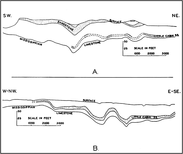
The two most prominent northwestward-trending structural features are the troughs near Lawton and Treece. The Lawton trough, which extends southeastward into Missouri, is just southwest of and parallel to the Joplin anticline. It continues with some interruptions beyond the Miami trough, its presence being indicated by the previously mentioned depressions southeast of Weir and Cherokee and also by a depression 5 miles northwest of Cherokee. The trough trending northwestward from Treece is known from mine workings and undoubtedly extends northwestward beyond the limits shown. There is also a fairly definite northwesterly alignment of depressions from sec. 25, T. 34 S., R. 24 E., to sec. 32, T. 33 S., R. 24 E. The deformation of the Cherokee shale in the northwest-trending depressions is similar to that in the northeast-trending depressions (fig. 6-A).
There are several places where the data were insufficient for drawing contours. For the most part, the strata in these areas are nearly horizontal, but some steep dips and departures from the normal regional slope were observed and are indicated on Plate 5.
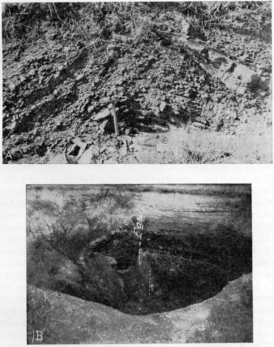
Small anticlinal folds were observed in several surface exposures, but were not considered as necessarily indicative of the structure of the Cherokee shale as a whole. Several cross sections of these folds are exposed in road cut ditches, such as one along Kansas State Highway No. 7, illustrated in Plate 6-A, another on the east side of the road along the SW sec. 25, T. 34 S., R. 23 E., and a third one along the north side of road at center of the north line NW sec. 6, T. 32 S., R. 25 E. A small fold is also well exposed in a creek bank near the southeast corner sec. 33, T. 34 S., R. 21 E.
Plate 6--A, Small fold in the Bluejacket sandstone member of the Cherokee shale, exposed along west side of road, near center east line sec. 36, T. 34 S., R. 23 E.; B, A fossil sink hole exposed in the wall of a recent sink in the NE sec. 9, T. 32 S., R. 25 E. The top of the Mississippian limestone is exposed on the right near the bottom of the sink; the Cherokee shale above it is in its normal stratigraphic position. A fault near the center of the picture marks the wall of a fossil sink with the beds to the left of it dipping steeply into the fossil sink hole. The fault seems to be curved in plan, dips 78 degrees to the west (left), and has a throw of about 6 feet.
Faults
Four normal faults are shown on the maps (Pls. 1 and 5). One is near the southwest corner of sec. 14, T. 33 S., R. 24 E., two are in T. 30 S., R. 23 E. (secs. 26 and 33), and one is in the northern part of T. 30 S., R. 25 E. The strike of two of the faults is northwest, one strikes north, and one has a northeast strike. The fault in the northern part of T. 30 S., R. 25 E. was not observed on the surface, but is inferred from mine and drill-hole data. Its horizontal extent is about 2 1/2 miles, but the others are less than a mile in length. The throw of all of them is small, probably less than 15 feet.
Sink holes
Both recent and ancient sink holes are present in the area, aside from cave-ins resulting from mining operations. The ancient sink holes may be distinguished from the recent ones by the term "fossil sink holes."
Nine recent sink holes were observed in Tps. 32 and 33 S., R. 25 E., and are shown on Plate 1. Three of these--one on the east side of Cow Creek in the NE sec. 9, T. 32 S., R. 25 E., the middle one in the group in the W/2 sec. 34, T. 32. S., R. 25 E., and the one in the NE sec. 29, T. 33 S., R. 25 E.--are merely shallow depressions about 10 feet deep. The sink hole in the NE sec. 34, T. 32 S., R. 25 E., is in the bed of Cow Creek and was filled in many years ago in an effort to lessen the flow of water in the mines in the Lawton area. The other five recent sink holes now exist as large, slightly elliptical open holes 75 to 125 feet in larger diameter and 30 to 60 feet deep. The rocks in the nearly vertical walls of the sinks are usually well exposed, for although the bottom receives material that slumps off the sides of the sink hole, the debris continues to move downward, owing to further subsidence at the bottom.
The sink in the SW sec. 34, T. 32 S., R. 25 E., and the one in the NW sec. 28, T. 33 S., R. 25 E., are reported to have formed about 1905, which was long before mining operations began at Lawton and Crestline. The northwestern one of the group of sinks in the W/2 sec. 34, T. 32 S., R. 25 E., formed about 1911. The sink in the bed of Cow Creek in the E/2 of the same section probably formed not long afterward, for it is reported that in 1912 the hole was filled in by the mining companies operating at Lawton. The shallow depression in the W/2 sec. 34, T. 32 S., R. 25 E., formed in 1922. The sink on the west side of Cow Creek, in the NE sec. 9, T. 32 S., R. 25 E., formed about 1921, and the one to the south of it in the same section formed in 1929.
The formation of some of the sink holes was preceded by a slight sagging of the ground, but in others a hole of about the present size and depth formed without warning. The history of two of the recent sinks, as told by local residents, is interesting. In 1911 a cultivated cornfield occupied the area where the northwestern one of the group of sinks in the W/2 sec. 34 is now located. A few years prior to 1911 a slight sag about 14 feet in diameter was noticed in the field, similar to the "buffalo wallows" of the high plains, except that it did not hold water. No preliminary cracks were noted. Then one day, while the field was being cultivated, a great open hole was observed where previously there had been only a slight depression. The hole was about 15 feet in diameter, with vertical walls, and after obtaining a piece of twine its depth was determined as 72 feet. Water was present in the bottom of the sink when it was first observed. Since its formation, the sides of the sink have occasionally slumped off, gradually enlarging the hole. In the winter of 1933 an area around the north rim sank about 20 feet. The sink hole near the center of the E/2 sec. 9, T. 32 S., R. 25 E., which formed in 1929, was indicated about five years previously by a crack which formed a few feet from the present west rim of the sink. A few years ago water from Cow Creek flooded the bottom land, completely covering the sink hole. Shortly after the flood subsided the sink was examined and found to contain water only at the very bottom. The water that had filled the hole presumably drained out rapidly through an underground channel. Water has always been present in the bottom of the sink, but at the time of the field examination it stood 27 feet below the water in Cow Creek, which is only 250 feet south of the sink hole. The fact that the water flowing in the creek was much higher than water in the sink hole indicates that the creek flows on a perched water table.
In four of the recent sinks the walls and steeply inclined or faulted beds of fossil sink holes may be seen. The surface of the ground above the fossil sink holes does not now give any indication of their presence, but the strata in them reveal the usual succession of the lower beds of the Cherokee formation dropped below their normal position. A photograph of a fossil sink exposed in the wall of a recent sink is shown in Plate 6-B. The owner of the land capitalized on this sink hole by putting it on exhibition at 10 cents per person and is reported to have done a good business for several months. The large opening shown in the photograph is the recent sink hole. In the right half of the picture is a normal section of lower beds of the Cherokee. The top of the Mississippian limestone is exposed near the bottom of the pit and is overlain by black shale, then a thin coal bed (Riverton), and above this the Little Cabin sandstone up to the top of the exposure,. Near the center of the picture is a fault with a throw of about 6 feet, which marks the wall of a fossil sink hole. The strata on the left dip steeply into the fossil sink. The strata in this and the other fossil sinks reveal the normal succession of Cherokee beds, such as exposed on the right side of the photograph, so it is obvious that at least these fossil sinks formed in post lower Cherokee time. The geologic date of formation of the fossil sink holes, however, is known only within wide limits. All of those observed are probably post-Cherokee, for strata above the middle of the Cherokee shale are deformed in the depressions previously mentioned near Weir and Cherokee, and they are older than Quaternary, to judge from the amount of erosion since they formed. A few sinks and depressions may have formed in pre-Cherokee time, but their number is thought to be small in comparison with those of post-Cherokee age. It is natural that the recent sink holes should be associated with fossil sinks, for such an association merely means either a continuation of or a return to the solution conditions of an earlier time at these places. There are also many fossil sink holes that are not associated with recent sinks; some of them can be seen in the walls of cave-ins resulting from mining and others are inferred from drill-hole data. Most of the recent sinks are on the intermediate to higher structural parts of the Mississippian limestone and are associated with the Miami trough or the Joplin anticline.
Prev Page--Stratigraphy || Next Page--Mineral Resources
Kansas Geological Survey, Geology
Placed on web July 27, 2011; originally published Sept. 1938.
Comments to webadmin@kgs.ku.edu
The URL for this page is http://www.kgs.ku.edu/Publications/Bulletins/24/05_struct.html