![]()
Prev Page--Geography || Next Page--Structure
Stratigraphy
General Statement
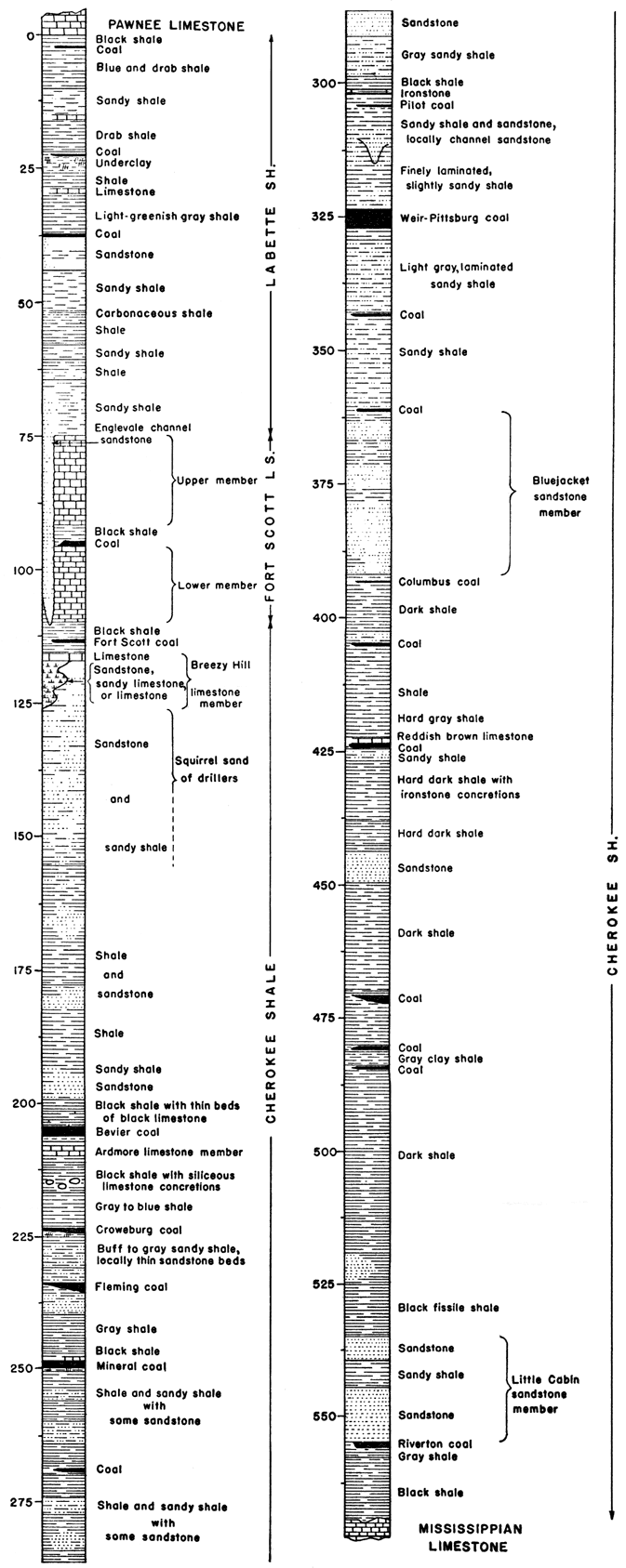
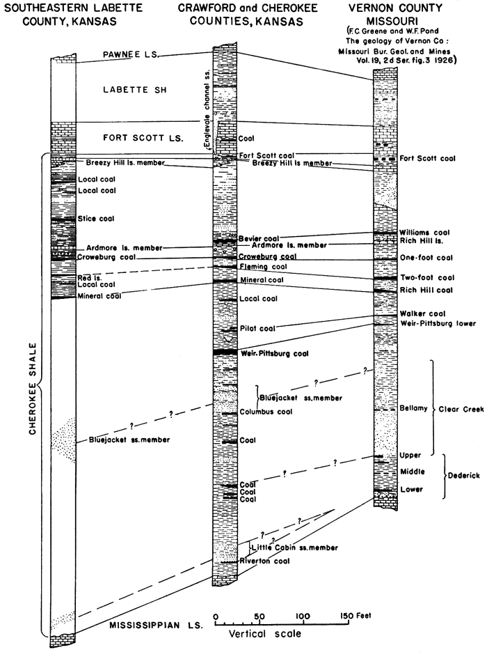
All of the strata exposed in the southeastern Kansas coal field belong to the Carboniferous system. They are all of Upper Carboniferous (Pennsylvanian) age except for the small area of limestone of Lower Carboniferous (Mississippian) age in the southeast corner of Cherokee County. The Cherokee shale, which lies unconformably on the limestone of Mississippian age, is of early Pennsylvanian age. The Cherokee is overlain by alternating beds of limestone and shale that form convenient units for division into geologic formations. The Fort Scott limestone at the base of this overlying series, the Labette shale, and the Pawnee limestone crop out within the area. All of the coal beds of economic importance lie within the Cherokee shale. Figure 2 shows a generalized section of the formations cropping out in the area.
Figure 2--Generalized section of the rocks of Pennsylvanian age in Crawford and Cherokee counties, Kansas.
Carboniferous System
Mississippian Series
Rocks of Mississippian age, consisting principally of limestone and chert, are exposed in a belt trending northeast across the southeast corner of Cherokee County. They form the surface over most of the area southeast of Spring River, and for a mile or so west of the river, except for structural depressions which contain patches of Cherokee shale.
Osage Subseries
NOTE: In place of the term Osage subseries, the authors of this report have employed "Boone limestone," a stratigraphic unit that, although shown on the recently published state geologic map of Kansas, is not recognized in the classification of the rocks of Kansas adopted by the State Geological Survey. This is because "Boone" is synonymous with the well-recognized, much older division called Osage, as this is currently defined. The State Geological Survey employs the classificatory designation "subseries," rather than "group," because the stratigraphic unit here embraced is separated by widespread unconformities from older and younger rocks and because of important faunal distinctions, which are believed to mark a definite time division.
In southeastern Kansas the youngest Mississippian rocks definitely known to be present below the Cherokee shale are beds (Warsaw limestone) belonging to the Osage subseries. Several formations of late Mississippian or Chester age occur between the limestone of Osage age and the lower Pennsylvanian strata in northeastern Oklahoma. Owing to erosion along the unconformity at the base of the Cherokee shale, these formations disappear northward, but some uncertainty exists as to just how far northward some of them extend. In the Joplin District folio, which extends into southeastern Kansas, Smith and Siebenthal (1907) have described the Carterville formation as being of Chester age, lying unconformably on the Boone limestone (Osage subseries) and overlain unconformably by the Cherokee shale. The Carterville, however, is not extended into Kansas and the Cherokee is mapped as lying directly on the Boone. On the other hand, Weidman's (1932) interpretation, from studies in northeastern Oklahoma, is that the *Mayes limestone (of Chester age and correlated with the Carterville) extends into Kansas and is present in the vicinity of Baxter Springs and also farther north in Cherokee County, Kansas. He describes the *Mayes as variable in character and thickness, consisting of limestone, shale, and sandstone, from 10 to 60 feet in total thickness.
[Note: An asterisk (*) preceding a geologic name indicates that the name has been abandoned or rejected for use in classification in publications of the U. S. Geological Survey and of the State Geological Survey of Kansas. Quotation marks, which were formerly used to indicate abandoned or rejected names, are now used only in the ordinary sense. Any case in which classifications of the Surveys differ is explained in footnotes.]
The question of the absence or presence of strata of Chester age in southeastern Kansas is one that requires a regional, as well as detailed study, and is beyond the scope of this report.
The surface features formed by erosion of the Mississippian rocks are distinct from the rest of the area, particularly from the Cherokee shale which overlies it. The valley slopes of the Mississippian rocks are abrupt and cliffs are common, whereas the valley slopes of the Cherokee shale are very gentle. In the Mississippian rocks the areas between large streams are broad and flat-topped; the upper reaches of tributary streams occupy small open valleys and their lower courses have deeper valleys that in places are bordered by low cliffs composed of limestone and chert. In contrast is the area of Cherokee shale that lies to the northwest where the dissection is much less, with fewer valleys, and these more open and much shallower.
Besides the main area of Mississippian limestone bordering Spring River, and to the southeast, there are several inliers, that is, patches of Mississippian limestone surrounded by the Cherokee shale, of early Pennsylvanian age. The largest inlier is in the vicinity of Lawton. Others are in the northern part of sec. 12 and the southern part of sec. 1, T. 34 S., R. 24 E., and the SW sec. 27, T. 33 S., R. 24 E., and adjoining sections. The mapping of the Cherokee-Mississippian contact north and west of Spring River is taken in part from the Joplin District folio, with changes at those places examined where revision seemed necessary. The areal mapping was not extended southeast of Spring River; for the geology of that area the reader is referred to the Joplin District folio.
Pennsylvanian Series
Des Moines Subseries (see note)
NOTE: The classificatory division called Des Moines subseries, not used by the authors of this report, is incorporated here to correspond with the classification of Kansas rocks adopted by the State Geological Survey of Kansas which recognizes this as one of the very significant subdivisions of the Carboniferous system. It constitutes the lowermost part of the Pennsylvanian series in Kansas, although older rocks (Morrow subseries) of Pennsylvanian age appear south of the Kansas-Oklahoma boundary. The U. S. Geological Survey recognizes Des Moines as a group term.
Cherokee shale
In 1894 Haworth and Kirk gave the name Cherokee shale to the thick shale and sandstone series lying above the Mississippian rocks and below the Fort Scott or Oswego limestone. The Cherokee shale crops out in a northeast-trending belt from 15 to 25 miles wide across Cherokee County and extends northeastward through Crawford County into Missouri. To the southwestward it extends into the easternmost part of Labette County, and on southward into Oklahoma.
In southeastern Kansas the Cherokee shale contains both marine and continental strata, with many recurrences of both types of deposits indicated by many marine fossil horizons and numerous coal beds. As the name indicates, it is predominantly a shale formation, but contains several beds of sandstone from 10 to 50 feet thick and numerous thinner beds of sandstone. In the upper half of the formation the shale is commonly gray in color and well laminated, except that black shale is present above some of the coal beds. Dark-gray and black shale are more abundant in the lower part of the formation. Limestone forms an insignificant part of the total thickness of the Cherokee shale but two limestone units, each only a few feet in thickness, are classified as members of the formation because they are good stratigraphic markers. The Cherokee contains numerous coal beds, most of them from 6 to 24 inches thick; the thicker and more important coals are in the upper half of the formation.
The basal part of the Cherokee is exposed at places along the belt of outcrop west and north of Spring River, and in recent sink holes, mine shafts, and cave-ins. It consists of 15 to 20 feet of dark to black laminated shale, which rests on either limestone or somewhat fractured chert. No conglomerate was found at the base of the Cherokee shale at any of the places examined, although Weidman (1932) reports the occurrence in Oklahoma of a bed of chert pebbles 3 to 4 inches thick at this horizon. A small sample of material from a 2-inch bed immediately above the Mississippian limestone exposed in the south bank of a small tributary of Spring River, about 1,600 feet due east of the northwest corner sec. 14, T. 33 S., R. 25 E., was submitted to the Chemical Laboratory of the Geological Survey for analysis. A report by J. J. Fahey is as follows:
The sample consists predominantly of a white, soft, hydrous, isotropic mineral having an index of 1.49. This mineral is probably allophane. The black material is carbonaceous matter. There is a minor quantity of quartz present. Manganese was found in the sample, probably as much as two or three percent. The specific gravity of the rock is 1.62.
Above the basal shale unit of the Cherokee is a coal bed from 6 to 14 inches thick, which the authors called the "Little Cabin" coal in a previously published statigraphic section (Pierce and others, 1935). However, in order to conform with the nomenclature recently adopted by the State Geological Survey of Kansas, Riverton is here used as the name for this coal bed.
Little Cabin sandstone member--The Little Cabin sandstone was named by Ohern (n.d.) from exposures along Little Cabin creek near Vinita, Craig County, Oklahoma. The name has been used in other reports (Cooper, 1927) on the geology of northeastern Oklahoma and is here extended into Kansas. The sandstone near the base of the Cherokee that is mentioned in the Joplin District folio (Smith and Siebenthal, 1907) is the Little Cabin.
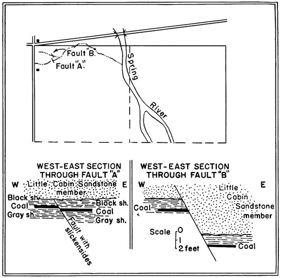
The base of the Little Cabin sandstone is irregular, but is normally from 15 to 20 feet above the base of the Cherokee. Inasmuch as the Little Cabin probably is not a continuous bed throughout the entire area, it is to be expected that variations in the interval between it and the base of the Cherokee occur. In places it is found 30 feet above the base of the Cherokee and in an area in and near the SW sec. 27, T. 33 S., R. 24 E., a sandstone correlated with the Little Cabin is at the base of the Cherokee. In some places 2 feet of black shale occurs between the Little Cabin sandstone and the Riverton coal bed beneath it, in other places the Little Cabin rests directly on the coal, or the Little Cabin may cut out the coal entirely. Where the Riverton coal is entirely cut out, fragments of coal may sometimes be found in the basal part of the sandstone. Some good exposures in a small eastward-draining draw in the NW NW sec. 14, T. 33 S., R. 25 E., show significant structural relations of the Little Cabin sandstone to the underlying shale, as shown in figure 3. The fault at "B" in the figure is of no particular interest, except to show slight movement in post-Little Cabin time. The fault "A," however, is of interest in regard to the time interval represented by the erosional irregularity at the base of the Little Cabin sandstone. Fault "A" has only about 7 inches of vertical displacement, but the shale along the fault surface is slickensided in a direction parallel to the dip of the fault. The fault extends up to the base of the Little Cabin sandstone, but does not extend into it. The inferences that may be drawn are (1) that the slickensided shale and coal below the Little Cabin sandstone were consolidated before the faulting, and (2) faulting and subsequent erosion preceded the deposition of the Little Cabin sandstone. The erosional irregularity at the base of the Little Cabin is usually only a few feet, but in the wall of a mine cave-in near the center of the east line of sec. 25, T. 32 S., R. 25 E., it may be seen to cut down about 15 feet below its normal position. Additional fieldwork, particularly to the southward where the Cherokee shale is several times thicker, may show that there is a significant time break at this horizon. At present, however, there are not sufficient data to indicate that the erosional irregularity at the base of the Little Cabin is of any greater importance than numerous irregularities at the base of other sandstones in the Cherokee (the relations here described are characteristic of the base of a cyclic sedimentary unit, called cyclothem, as explained in Kansas Geol. Survey, Bull. 25, 1936).
Figure 3--Sketch map and cross sections of two small faults in the N/2 sec. 14, T. 33 S., R. 25 E.
The Little Cabin sandstone member is a brown to buff, medium-grained sandstone, 10 to 20 feet thick, similar in appearance to other sandstones occurring higher in the Cherokee, except that it is in part slightly coarser grained. At some places it consists entirely of sandstone, is massive and crossbedded, whereas at other places it is thin-bedded, with several feet of sandy shale or shale just above the middle portion. Locally the lower part of the member contains tabular pieces of shale from one-fourth to one-half inch in length, which on weathering are removed and leave slitlike cavities in the rock. In many fresh exposures, such as recent sink holes or mine cave-ins, the lower half is soaked with a thick black oil residue.
The Little Cabin sandstone member is fairly persistent along the strike--that is, in a southwesterly direction, but drill record data indicate that it is discontinuous toward the northwest. Its distribution suggests that it is a beach, or near-shore deposit laid down along the eastern margin of the Cherokee sea, rather than a stream channel deposit. To the northeast, near the Kansas-Missouri line, the Little Cabin sandstone apparently becomes thinner and in places passes into sandy shale.
| Section of the lower part of the Cherokee shale and the Little Cabin sandstone member, measured in the undisturbed wall of a recent sink hole, in the NW NE sec. 9, T. 32 S., R. 25 E. | Feet | ||
|---|---|---|---|
| Cherokee shale | |||
| Shale, black, fissile | 10+ | ||
| Little cabin sandstone member: | |||
| Sandstone, dark, fine-grained; weather nodular and pitted | 0.4 | ||
| Sandstone, light brown, white at top; hard | 4 | ||
| Shale, sandy, thin-bedded, dark; local beds of sandstone | 5 | ||
| Sandstone, crossbedded, brown to black, asphaltic; tabular cavities, some filled with pyrite | 11 | ||
| Coal (Riverton), variable in thickness from 6 to 11 inches | 0.9 | ||
| Shale, gray | 3 | ||
| Shale, black, laminated; contains one-fourth to one-half inch vertical veins of calcite; in places the lower 6 inches contains a few small angular fragments of chert | 11.5 | ||
| Mississippi series, chert | 2+ | ||
| Total section measured | 47.8 | ||
Beds between the Little Cabin and Bluejacket sandstone members--Little is known of the detailed stratigraphy of the 150 feet of beds above the Little Cabin sandstone, except that it consists principally of dark shale with four or five coal beds from 6 to 18 inches in thickness. It contains a few local sandstone beds, which in places crop out as hard sandstone ledges. In Oklahoma this unit contains a 6- to 10-inch bed of limestone, which Weidman (1932) calls the "Elm Creek limestone." It is described as occurring 10 to 20 feet below the Bluejacket sandstone. However, in Kansas, no persistent limestone was found at this horizon, or in fact in the whole lower half of the Cherokee, although a few thin lenticular, fossiliferous beds were found. Most of these limestone beds are black and rest upon coal. In the weathered material on the dumps of several shallow coal strip pits, many tabular pieces of porous, limonitic, sandy shale an inch or so in thickness were observed. Some are so porous that at first glance they look like fused or clinkered rock. They are particularly abundant in the strata between the Little Cabin and Bluejacket sandstone members. A specimen from a strip mine dump in the SW sec. 18, T. 32 S., R. 25 E., and another from unweathered shale in the NW NW sec. 2 of the same township were examined in the Chemical Laboratory of the Geological Survey; a report by Charles Milton states in part:
An examination of the specimens and of thin sections prepared from them indicates that they are indurated sandy shales, with conspicuous brown and black limonite. The more porous specimen shows no definite bedding and in the other the bedding is ill-defined. The limonite is banded, indicating deposition from aqueous solution of the iron in its present form. Both specimens consist of quite stable material and no processes of oxidation, leaching, or the like appear likely to affect them.
Neither natural nor artificial exposures permit the measurement of any considerable thickness of continuous stratigraphic sequence of beds between the Little Cabin sandstone and the Weir-Pittsburg coal about 200 feet above it. A section in the lower part of the Cherokee totaling 112 feet 11 inches, is published in the Joplin District folio (Smith and Siebenthal, 1907). In the course of the present investigation, an attempt was made to verify the units of this section at the Betty Place, in sec. 19, T. 33 S., R. 25 E. After failing to find sufficient outcrops for recording a detailed section, the original field notes were consulted and they revealed that the section was compiled principally from a well log. The best exposures of this part of the Cherokee beds that were found, begin in the south bank of Brush creek, about 800 feet southwest of the center of sec. 10, T. 34 S., R. 24 E., and extend southeastward to an old sandstone quarry. The log of a hole drilled about 700 feet southwest of the quarry and near the center of the small area of Bluejacket sandstone, shown on Plate 1, records at the top of the hole 9 feet of sandstone and the base of the Cherokee at a depth of 205 feet. The east and northeast dips of 3 to 5 degrees indicate this section is on the flank of a syncline or a very large sink hole.
| Section measured northwestward from a sandstone quarry to the south bank of Brush Creek, NE SW sec. 10, T. 34 S., R. 24 E. | Feet | |
|---|---|---|
| Cherokee shale | ||
| Soil | 1 | |
| Sandstone, upper ledge 40 inches thick, lower part massive with base concealed; exposed in old quarry (lower part of Bluejacket sandstone member) | 6 | |
| Concealed | 18± | |
| Shale, sandy, buff-yellow | 1 | |
| Shale, gray | 0.5 | |
| Coal | 0.9 | |
| Shale, gray | 1 | |
| Concealed, upper 3 feet probably light-gray shale, underlain by clay-shale | 8 | |
| Shale, gray, hard, micaceous, with some ironstone beds | 8 | |
| Limestone, reddish-brown, hard | 0.7 | |
| Shale | 0.2 | |
| Coal | 0.5 | |
| Shale, gray | 0.5 | |
| Shale, sandy, buff; light-gray clay in middle | 3 | |
| Shale, dark, hard, with some ironstone beds | 14 | |
| Shale, dark, flaky, with irregular ironstone nodules | 5 | |
| Ironstone | 0.2 | |
| Shale, dark | 1 | |
| Total section | 69.5 | |
| Interval to base of Cherokee from drill record | 135± | |
Although a thickness of 45.5 feet of strata was measured along the south side of Cow Creek in the NW NW sec. 28, T. 31 S., R. 25 E., their stratigraphic position in the Cherokee is unknown. The entire exposure dips 22 degrees east-northeast, but within a quarter of a mile both to the east and west the strata assume their normal flat-lying position.
Bluejacket sandstone member--The Bluejacket sandstone was named (Gould, 1925) from the town of Bluejacket, in Craig County, Oklahoma, and has been mapped northward to the Oklahoma-Kansas line. Although the Bluejacket cannot be traced with certainty as a continuous unit in Kansas, the name is applied to the prominent sandstone that is exposed just east and south of Columbus and that caps the Timbered Hills 2 miles southwest of Crestline. It is possible that the base of the Bluejacket sandstone in the area southwest of Columbus to the Kansas-Oklahoma line does not represent a continuous bed or even the same stratigraphic horizon, because the lack of outcrops makes it impossible actually to trace any bed more than a few hundred feet. The base of the Bluejacket, as shown on Plate 1, however, represents the base of a fairly thick sandstone unit, so far as could be determined from careful field observations in conjunction with drill hole data. It was not mapped northeastward beyond sec. 33, T. 32 S., R. 24 E., about 4 miles northeast of Columbus. Sandstone at approximately the horizon of the Bluejacket was observed at a number of places in the area between Pittsburg and Opolis, but is not shown on the map (Pl. 1). In places it is underlain by the Rowe coal bed. The term Columbus sandstone was proposed by Haworth and Kirk (1894) for the sandstone exposed southeast of Columbus, but was defined rather loosely and would probably include both the Little Cabin and Bluejacket sandstone members.
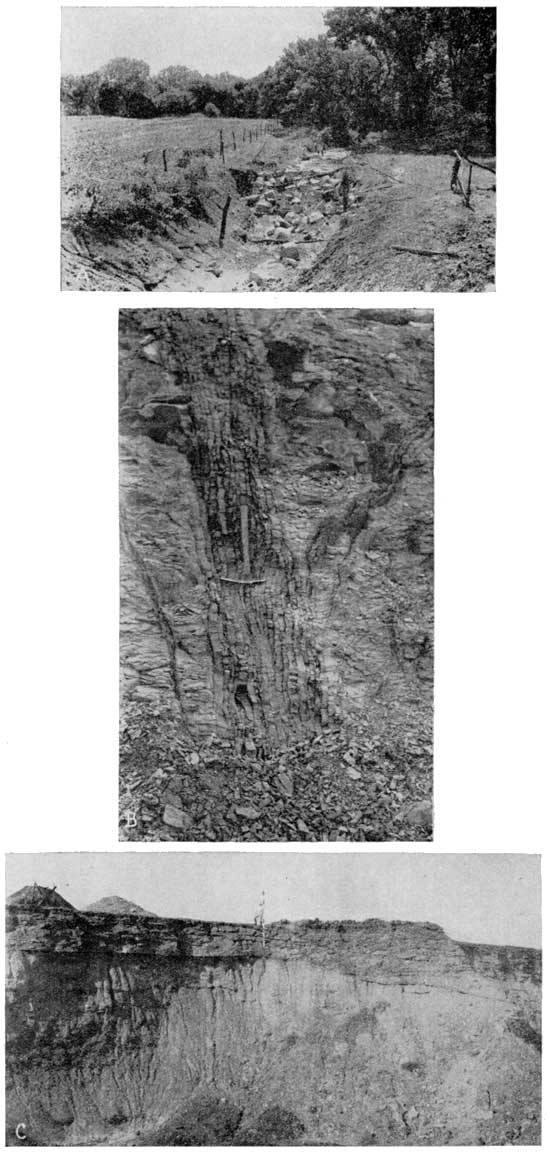
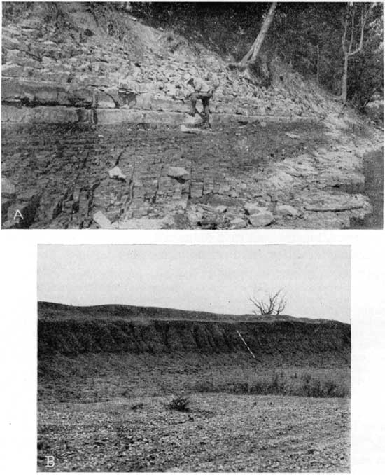
The Bluejacket sandstone is between 20 and 50 feet in thickness, and its base is 50 to 100 feet below the Weir-Pittsburg coal. In places the base of the Bluejacket is irregular, possibly as much as 20 feet. At a small strip mine about 800 feet east of the center of sec. 20, T. 33 S., R. 24 E., the Bluejacket sandstone contains a basal conglomerate with cobbles up to 6 inches in diameter that were derived from the shale and concretions of the lower part of the Cherokee. All of the material composing the conglomerate was apparently derived from the Cherokee shale. There were no pieces of chert or limestone from the underlying Mississippian rocks. At many places the Columbus coal bed, with a thickness of 6 to 12 inches, occurs a few feet below the Bluejacket sandstone, but at other places it is absent, suggesting that to some extent it may have been removed by pre-Bluejacket erosion. Plate 2-A shows some thin lenses of coal observed a few feet above the base of the sandstone along Brush Creek, but, so far as known, the Columbus coal is not present here.
Plate 2--A, Lenses of coal 1/4 to 3 inches thick in the lower part of the Bluejacket sandstone on the south bank of Brush Creek in the NW sec. 29, T. 33 S., R. 24 E.; B, Pseudo-dip in the laminated shale overlying the Weir-Pittsburg coal in strip pit in NW sec. 8, T. 32 S., R. 24 E. Top of coal bed indicated by lower end of stadia rod is parallel to floor of pit, and the bedding planes of the overlying shale, which are parallel to the coal bed at left, dip at an angle to the coal at right.
A road cut at the northwest, corner of sec. 23, T. 33 S., R. 24 E., made at the time of the field investigation, revealed a fresh exposure of the basal part of the Bluejacket sandstone. When freshly exposed, both the bedding and color of the sandstone are seen to be unusual. The individual beds of sandstone seemingly thin westward, but the thinning apparently is due in part to truncation by each overlying bed. The most prominent bed thickens from 1 to 13 inches in a distance of 25 feet. The two-toned color of the sandstone beds is even more striking, for most of them show a distinct change in color near the middle of each bed. The beds are from an inch or two to a foot thick; the upper half is lighter colored, from buff to light brown, and the lower half is medium to dark gray. The color differences apparently did not originate as a result of the small normal fault at this locality; neither are they characteristic of the Bluejacket sandstone, for they were not observed elsewhere. A specimen was submitted to the chemical laboratory of the Geological Survey; the report of an examination by Charles Milton is as follows:
The sandstone consists of over 95 percent of uniform, angular to subrounded, quartz grains with little interstitial clayey material. A few black areas, not over a millimeter across, are visible in the hand specimen; under the microscope much smaller opaque areas are seen distributed throughout the rock. The gray color in the lower part of the bed is due to organic matter, or some form of carbon. On strong ignition, the rock burns white. On heating in a closed tube, only a doubtful odor is observed. The difference in color of the two parts of the rock is due, however, to more carbonaceous matter being present in the dark part as shown by the following experiment: A portion of a few grains of the gray rock was placed in a test tube with 10 cc of KMnO4 solution, and a similar tube of KMnO4 prepared as a blank. After one day, the tube with the gray rock showed marked reduction of the KMnO4 as compared with the blank. After a week, the blank was virtually unchanged; the KMnO4 with the gray rock almost decolorized. Similarly, a portion of the gray rock, and one of the light rock, were treated with KMnO4. The gray rock decolorized the KMnO4, and the light rock hardly affected it at all after three days. It is concluded that the dark color in the lower part of the bed is due to carbonaceous material, which reduces KMnO4, and can be burnt off; the light-colored rock does not contain this reducing material. Solubility tests with organic solvents were negative, indicating that the material is not a hydrocarbon, but probably of a coaly nature. An attempt was made to measure the relative quantity of organic matter in the two portions of rock, by treating the crushed rock with hot dilute H2SO4, filtering, and adding KMnO4 to the filtrate. The reduction, however, was negligible, indicating that the carbonaceous material did not dissolve to any appreciable extent. The crushed rock was then added to the filtrate, and the mixture heated to boiling; the permanganate solution (approximately .03) was added from a burette. The light-colored rock showed a permanent end point on addition of 4 cc; the gray rock after 13. The gray rock was visibly bleached by this treatment, approaching the buff-colored rock. It is concluded that the carbonaceous matter in the gray rock is on the order of three times that in the light colored.
The Bluejacket sandstone occurs in approximately the same part of the Cherokee shale as the Bartlesville shoestring sands of Greenwood and Butler counties, Kansas. Bass (1934) gives evidence, from a subsurface study, which indicates that they were deposited as offshore bars bordering the coast of a shallow sea in Cherokee time. The areal distribution of the Bluejacket sandstone and the occurrence of marine invertebrates and land-plant fossils suggest that the sand is a shore deposit rather than a channel deposit. If it is a shore or offshore deposit, it was probably formed on the eastern side of the Cherokee sea.
Beds between Bluejacket sandstone member and Weir-Pittsburg coal--No detailed section could be measured of the strata between the top of the Bluejacket sandstone and the Weir-Pittsburg coal. Neither could the exact thickness of this interval be determined, owing in part to the fact that the top of the Bluejacket is indeterminate, but from drill-hole records and calculations from surface data, it is estimated to be about 35 feet. Small outcrops within this unit show that it consists principally of sandy shale with one or two thin coal beds. Sandy shale in the upper half of this unit, obtained from clay pits just southeast of Pittsburg, is used in the manufacture of brick and tile.
Weir-Pittsburg coal and overlying shale--The Weir-Pittsburg coal is here discussed with the other stratigraphic units of the Cherokee shale, because it can be traced definitely for many miles by the mine workings and strip pits that have been made near the outcrop of the coal, and furthermore, it furnishes the only stratigraphic horizon near the middle of the Cherokee which can be recognized. It is by far the thickest coal in the district; this distinguishes it from the other coal beds in the Cherokee shale, even though its thickness is only about 3 feet. Practically the entire extent of the Weir-Pittsburg coal is shown on Plate 1, extending from about a mile east of Arcadia to 2 miles north of Columbus. Inliers of the coal occur just west of Arcadia and in the city park at Pittsburg. Outliers occur at several places to the east or southeast of the principal line of the outcrop. The Weir-Pittsburg coal is overlain by 10 to 30 feet of light-gray, finely laminated, sandy shale. At several places the bedding of the shale is not parallel to the Weir-Pittsburg coal, but lies at an angle of several degrees to it. This is a peculiar feature of sedimentation, in view of the fact that the shale is so minutely laminated. The shale, however, does not seem to be unconformable on the coal. The many thin beds of shale each appear to thicken slightly and thus produce the pseudo dip. This feature is well exposed in the north wall of a pit at the center of the north line of the NE sec. 19, T. 30 S., R. 25 E., and also in a pit in the NW sec. 8, T. 32 S., R. 24 E. (see Pl. 2-B).
The interval between the Weir-Pittsburg coal and the Ardmore limestone member consists of shale, sandy shale, some sandstone, and five coal beds, which are described in detail under the discussion of coal. Some of the coal beds are overlain by a few inches of lenticular black limestone. The most distinctive bed in this unit is a black shale which contains both large and small calcareous and pyritic concretions and lies between the Croweburg coal and the Ardmore limestone. This black shale with the concretions is very helpful in identifying the Croweburg coal and is more fully described in the discussion of that coal bed. A photograph and sketch of the bed are shown in Plate 8-B and figure 8. The thickness of the strata between the Weir-Pittsburg coal and the Ardmore limestone is about 100 feet in Tps. 27 and 28 N, and increases to the south-southwest to about 135 feet. The Mineral coal is somewhat above the middle of this unit. Its outcrop has been mapped and is shown on Plate 1.
Ardmore limestone member and overlying shale--In 1893 the name Ardmore limestone was used in a Missouri Geological Survey report on the Bevier topographic sheet (Gordon, 1893) in north-central Missouri. In 1926 Greene and Pond used "Rich Hill" for a limestone known to be near the same horizon as the Ardmore, and in a later report Greene (1933) indicates that he regards them as equivalents. The authors had correlated this limestone of southeastern Kansas with the adjoining "Rich Hill" of Vernon County, Missouri, and favored using this term, but decision as to which name should be extended into Kansas was left to the Kansas Geological Survey. A conference of that survey on nomenclature for southeastern Kansas favored extension of Ardmore rather than "Rich Hill." Ardmore, as therefore used in this report, is an exact equivalent of the "Rich Hill" of Vernon County and the approximate and probable equivalent of the Ardmore of north-central Missouri. It is locally known as the "Diamond Rock," because of a tendency to break into diamond-shaped blocks (see Pl. 3-A).
Plate 3--A, Outcrop of the Ardmore limestone member of the Cherokee shale one-fourth mile south of northwest corner sec. 32, T. 27 S., R. 25 E.; B, A peculiar type of weathering in the "Squirrel sand," forming dikelike bands in a road cut along west line NW sec. 5, T. 28 S., R. 25 E. The vertical and inclined bands consist of the same material as the horizontally bedded sandy shale on both sides and seem to be related to the action of ground water along joints and fractures; C, Irregular contact of sandstone on shale within the Cherokee about 30 feet above the Weir-Pittsburg coal in strip pit in the northwest corner sec. 20, T. 32 N., R. 33 W., Barton County, Missouri. The coal bed is at the bottom of the pit.
The lower part of the Ardmore limestone is much the same throughout its extent in southeastern Kansas. It is commonly a single bed of limestone, 1 to 2 feet thick, weathering to a mottled-yellow-buff color and is more or less jointed. The fresh limestone is dark bluish gray and buff, compact, very hard, fine-grained, and at the top is abundantly fossiliferous. The mottled aspect is characteristic and is much more prominent on a weathered surface because the darker blocks are more resistant to weathering and stand up in relief. Chemical analyses of both the light parts and the darker more resistant blocks were made by George Steiger in the Geological Survey laboratory. The two types of limestone show several differences in chemical composition, notably in larger amounts of silica, magnesium, iron, and aluminum oxides in the light-colored parts. The analyses are as follows:
| Soluble in 1-5 HCl, boiling 5 minutes |
Insoluble in 1-5 HCl, boiling 5 minutes |
|||
|---|---|---|---|---|
| Dark portion |
Light portion |
Dark portion |
Light portion |
|
| SiO2 | 0.11 | 0.23 | 2.35 | 8.66 |
| Al2O3 | 0.18 | 0.93 | 0.71 | 3.32 |
| Fe2O3 | none | none | 0.71 | 0.76 |
| FeO | 0.80 | 4.44 | .... | .... |
| MgO | 1.23 | 6.00 | 0.17 | 0.35 |
| CaO | 50.92 | 36.02 | none | none |
| TiO2 | none | none | 0.04 | 0.13 |
| MnO | 0.19 | 0.18 | .... | .... |
| CO2, water, alkalies, not determined. | ||||
The upper part of the Ardmore limestone is usually not exposed. It is much softer than the lower part, is nodular and concretionary, and contains thin beds of shale or clay. It is from an inch or less to 3 feet thick.
A few inches above the Ardmore limestone is a coal bed that is overlain by several feet of black shale containing a few thin beds of limestone. Above this is mostly shale and sandy shale that grades upward into a sandstone which drillers have called the "Squirrel sand."
"Squirrel sand" of drillers--Drillers have applied the name "Squirrel sand" to the sandstone near the top of the Cherokee shale, because of the manner in which it "jumps around," that is, varies in distance below the limestone markers above it (Greene, 1933).
The "Squirrel sand" lies just below the Breezy Hill limestone and extends downward an indefinite distance. An exposed thickness of 35 feet of sandstone was measured at a few places, with the strata below that depth concealed. Usually the sandstone is thinner than this and grades imperceptibly into shale below. It is mostly fine grained and grades laterally into sandy shale, so that in places there is no sandstone present beneath the Breezy Hill limestone.
A peculiar type of weathering commonly occurs in the outcrops of the "Squirrel sand," producing the dikelike structures shown in Plate 3-B. Bands of sandy shale or shaly sandstone, consisting of the same material as the adjoining strata, lie at various angles to the bedding. These bands may be perpendicular to the bedding and thus simulate dikes, or they may curve from a vertical to a horizontal position. Where two or more bands intersect there may be a series of concentric bands like the layers of an onion. The bands are thought to be related to the action of ground water along joints and fractures in the sandy shale.
Breezy Hill limestone member and overlying shale.-The Breezy Hill limestone member of the Cherokee shale is here named from the exposures at Breezy Hill, just southwest of Mulberry, Kan. Throughout much of its extent in southeastern Kansas it is a gray, impure, concretionary to nodular limestone from 6 inches to 2 feet thick, but in places exhibits considerable variation, both in thickness and in the character of material. In most places it is from 1 to 3 feet below the Fort Scott coal; where the coal is absent the Breezy Hill still occupies its same stratigraphic position and is from 4 to 8 feet below the top of the Cherokee shale. The Breezy Hill limestone is underlain by the "Squirrel sand."
On the west side of Breezy Hill, the Breezy Hill limestone consists of a foot or two of impure limestone. In the eastern part, of the hill, however, it thickens to a maximum of 8 feet and is similar in appearance to the lower member of the Fort Scott limestone. In a section measured by Greene (Greene and Pond, 1926) near Mulberry, Kan., the limestone called Breezy Hill in the present report was erroneously correlated as the lower member of the Fort Scott limestone. In Vernon County, Missouri, however, he recognized the Breezy Hill limestone as a bed (Greene and Pond, 1926) within the Cherokee shale. Where the Breezy Hill limestone is thick it simulates the lower member of the Fort Scott in appearance, but the two can be differentiated by the fact that the lower member of the Fort Scott limestone is underlain by several feet of black, slaty shale, whereas the Breezy Hill limestone is underlain by gray, sandy shale or fine-grained sandstone.
In a paper on correlation and extent of Pennsylvanian cyclothems, Wanless and Weller (1932) give several generalized sections. The one for western Missouri and eastern Kansas shows a limestone--the Breezy Hill of this report--below the lower Fort Scott limestone. It is indicated as equivalent to the freshwater limestone of the Summum cyclothem of Illinois. Many fossil collections were made from the Breezy Hill limestone in southeastern Kansas and according to the report by Williams, which follows, all of the fossils are marine.
An unusual facies of the Breezy Hill limestone occurs along the highway, 5 miles due west of Pittsburg. There the upper part of the Breezy Hill limestone consists of about 3 feet of gray, crystalline, fossiliferous limestone with 6 1/2 feet of massive, sandy, micaceous limestone below. It is underlain by 6 feet of brown thin-bedded sandstone, the upper half of which is calcareous.
Near the Kansas-Oklahoma line, in Labette County, the Breezy Hill limestone increases greatly in thickness. Along the west line of the NW NW sec. 1, T. 35 S., R. 20 E., it is 20 feet thick and consists of crystalline limestone, some thin beds of sandstone or sandy shale, and chalky limestone. At other places in this vicinity, where the Breezy Hill is only a few feet thick, other thin beds of limestone were observed below it. This fact, in conjunction with the practically continuous 20-foot limestone section noted above, suggests that the Breezy Hill increases in thickness with an interfingering relationship to the underlying sandstone.
Above the Breezy Hill limestone is a foot or so of gray clay-shale, overlain by several feet of black fissile shale. In the northern part of the field the Fort Scott coal occurs at the base of the black shale. A more detailed description of this coal and its associated strata is given in the discussion of the Fort Scott coal. The contact between the Cherokee shale and the overlying Fort Scott limestone is conformable, but is sharp and distinct, for the limestone of the Fort Scott rests upon the black shale at the top of the Cherokee. Neither stratigraphic nor paleontologic data indicate any time break between Cherokee and Fort Scott deposition.
Thickness of the Cherokee shale--The thickness of the Cherokee shale has been of interest to geologists, because of its connection with the problem of correlating the producing horizons in the oil and gas fields which lie to the westward. Maps depicting the variations in thickness of the Cherokee shale have been made, some of which have been published. One by Berger in 1918, covers approximately 17 counties in southeastern Kansas and northeastern Oklahoma, and a recent, one by Bass (1934) covers a large area in southeastern Kansas. Additional information, resulting from a detailed study of a smaller area comprising three counties, warrants the publication of a map showing the thickness of the Cherokee shale, even though the regional picture as previously known remains unchanged.
Figure 4 shows the thickness of the Cherokee shale in Crawford, Cherokee, and Labette counties by means of isopach (equal thickness) lines. Logs of numerous drill holes and wells were used for the compilation of the map. In those parts of the area where the top of the Cherokee is not present, particularly in Cherokee County, the depth from some recognizable horizon to the base of the shale was determined and to this figure was added the average interval from that horizon to the top of the shale.
Figure 4--Map showing thickness of the Cherokee shale in Crawford, Cherokee, and Labette counties, Kansas. Isopach lines--connecting points of equal thickness--at intervals of 20 feet.
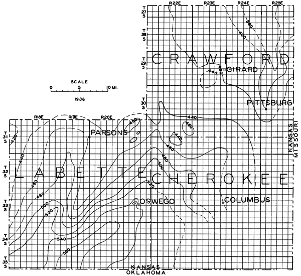
The Cherokee shale is only 375 feet thick in the northeast corner of Crawford County. It increases in thickness to the southwest, and in southern Labette County reaches a thickness of 560 feet. This increase in thickness is gradual and occurs principally in the lower half of the formation. The thickness of the upper half of the Cherokee shale remains remarkably uniform, except for two small local areas in the northeastern part of the district. On the east side of Breezy Hill, the interval from the top of the Cherokee to the Weir-Pittsburg coal is 30 to 40 feet less than the average, and on a hill near Oskaloosa the interval from the Ardmore limestone to the top of the Cherokee is about 60 feet less than the average. The thinning at both of these localities takes place mostly in the noncoal-bearing interval between the Bevier and Fort Scott coals.
Unconformity at the base of the Cherokee shale--The Cherokee shale lies unconformably, though without stratigraphic discordance, upon the Boone limestone. The nature of the terrane upon which the Cherokee was deposited has been described by some earlier writers (Haworth, 1898; Smith and Siebenthal, 1907) as one of considerable relief and irregularity, with a karst (Fowler and Lyden, 1932; Weidman, 1932) topography of sink holes and subterranean rivers. Later work, however, has tended to minimize the amount and extent of erosional irregularity at the top of the Mississippian. Recent papers by the senior author (Pierce, 1935a) have called attention to evidence indicating that the Cherokee was deposited upon a surface of low relief.
Drill-hole data show marked irregularities in the contact between the Cherokee shale and the Mississippian limestone; for example, one hole may strike the limestone at a depth of 200 feet, whereas another hole at the same elevation and only a few hundred feet away may encounter the limestone at a depth of 275 feet. Numerous irregularities of this kind, with many of them so distributed that they do not fit into a conventional structural pattern, presumably led to the assumption of a pre-Cherokee karst topography. Field data, however, failed to reveal any confirmation of this assumption. None of the outcrops examined showed any evidence of a pre-Cherokee karst topography, or evidence that the Cherokee was deposited upon a limestone surface that had considerable relief. The uniform section at the base of the Cherokee, consisting normally of about 20 feet of dark shale overlain by a coal bed followed by the Little Cabin sandstone, is indicative of a fairly uniform surface of low relief. The variation in thickness of the Cherokee, as shown in figure 4, is small in relation to its lateral extent. With a maximum variation in thickness of 185 feet in a distance of about 50 miles, and a maximum thickening of not more than 20 feet per mile, the erosional irregularities at the base of the Cherokee cannot be very large. The Cherokee beds that lie in the "fossil" sink holes, described in the discussion of structure, are deformed--indicating that the sink holes were formed after the deposition of the Cherokee beds. That these sink holes were not present in pre-Cherokee time is shown by the fact that, except for deformation, the lithology of the basal Cherokee is the same within the sink holes as outside of them. The irregularity of the unconformity between the Cherokee shale and the Mississippian limestone in southeastern Kansas is therefore believed to be due mainly to post-Cherokee folding, faulting, and solution.
In the SW sec. 27, T. 33 S., R. 24 E., and adjoining sections, small inliers of Mississippian limestone are overlain by sandstone. This relationship can reasonably be interpreted as one of nondeposition of the basal Cherokee beds upon an area of slight relief of the Mississippian surface. According to this interpretation, the sandstone would be correlated with the Little Cabin sandstone member, which is normally 15 to 20 feet above the base of the Cherokee shale, and would also thus give a rough measure of the greatest amount of indicated relief on the base of the Cherokee.
Unconformities within the Cherokee shale--The erosional irregularities at the base of the Little Cabin sandstone and below the Bluejacket sandstone have been mentioned previously; the small fault described just below the Little Cabin sandstone suggests a time interval of some significance, and the conglomerate observed at the base of the Bluejacket may indicate an unconformity at this horizon within the Cherokee shale. A sandstone between the Weir-Pittsburg and Pilot coal beds also exhibits an unconformable relationship at a few places, notably near the Fairview school in the northeast corner sec. 19, T. 32 N., R. 33 W., Barton County, Missouri, where there are excellent exposures in strip pits to the north, northeast, and east. In the pit to the north there is a coarse conglomerate a foot above the base of the sandstone, composed of material presumably derived from the Cherokee shale. Plate 3-C shows this sandstone lying unconformably on the shale above the Weir-Pittsburg coal. A sandstone about 16 feet above the Mineral coal shows a sharp irregular contact with the underlying shale in an exposure in a strip pit near the center of the west line sec. 13, T. 29 S., R. 25 E.
It is a question whether these horizons within the Cherokee shale represent time intervals of importance or are simply the record of change of conditions of sedimentation that took place during the deposition of the Cherokee shale. The writers prefer to consider them in the latter category until it is definitely demonstrated by future work that they indicate sizable time intervals represented by nondeposition and possible erosion which extended over a considerable area.
Correlations--Correlations of coals in the Cherokee shale in western Missouri with those of southeastern Kansas are shown graphically in figure 5. The writers have little doubt as to the validity of the correlations shown above the Weir-Pittsburg coal, near the middle of the Cherokee shale, for they apply not only to contiguous areas, but the distinguishing characteristics of individual coal beds and their overlying strata, which are described in the discussion of coal, tie the sections in perfectly. Paleontologic data given in the report following, by Williams, is also in harmony with the lithologic correlations that we have carried across to the southeastern Kansas coal field. The generalized sections of the strata below the Weir-Pittsburg coal are distinctly different in the two areas and the tentative correlations indicated are theoretical and are offered only as suggestions.
Figure 5--Generalized sections showing the position of coal beds and stratigraphic units in the southeastern Kansas coal field and their correlations with those of Vernon county, Missouri.
Eleven collections of fossil plants, ranging stratigraphically from near the base to within 30 feet of the top of the Cherokee shale of southeastern Kansas, were submitted to C. B. Read, of the United States Geological Survey, for identification and suggestive correlation with the Oklahoma section. His report in part, is as follows:
The collections are too small to permit extremely close age determination. I believe that the Cherokee shale, which yielded these fossils, is all of Allegheny age. The small flora from the Little Cabin sandstone suggests the Hartshorne of Oklahoma and is probably equivalent to the flora from the Jordan coal of Missouri. The collections near the Bluejacket sandstone, although quite incomplete and in consequence of questionable value for purposes of correlation, suggest in terms of the Oklahoma section, either uppermost Savanna or lower Boggy. It is certainly younger than Hartshorne or McAlester. The absence of Linopteris rubella and the presence of abundant Neuropteris ovata and N. desorii are very suggestive of lower Boggy. Of course, this applies only in the instance of the extension of my Oklahoma floral zone (Am. Assoc. Petroleum Geologists, 1934, Bull., v. 18, p. 1056) into Kansas. Collections from the Weir-Pittsburg coal are too small to furnish much information. It is possible that this coal may be lower Boggy in age. The collections from the Mineral coal and from 30 feet below the top of the Cherokee are from horizons higher than those for which I have information in Oklahoma. I am inclined to guess they are upper Boggy or higher.
The several localities from which fossil plants were obtained and the names of the species as identified by C. B. Read are given below.
- From 1 to 1 1/2 feet above top of Little Cabin sandstone member, 1 1/2 miles northwest of Lawton, Kan.: Neuropteris scheuchzeri, n. sp.; Annularia sphenophylloides.
- From a bed 10 feet below Bluejacket sandstone member, NE sec. 28, T. 33 S., R. 23 E.: Neuropteris rarinervis.
- From shale 18 feet below top of well in SW SE sec. 9, T. 31 S., R. 25 E.: Neuropteris scheuchzeri, N. missouriensis.
- From shaly zone in lower part of Bluejacket sandstone member (collection of C. M. Cooper, Columbus, Kan., obtained from ditch excavation in southeast part of Columbus), NW NE sec. 24, T. 33 S., R. 23 E.: Neuropteris ovata (abundant), N. desorii, N. scheuchzeri, Pecopteris richardsoni, Annularia stellata, Sphenophyllum majus?.
- From bed a few feet below Bluejacket sandstone member, SE sec. 7, T. 33 S., R. 24 E.: Stigmaria ficoides.
- From bed a few feet below Weir-Pittsburg(?) coal, 1,500 feet west of southeast corner sec. 15, T. 33 S., R. 22 E.: Alethopteris serlii.
- From bed 25 feet above Weir-Pittsburg coal. Strip pit in SE sec. 17, T. 32 N., R. 33 W., Barton County, Missouri: Sigillaria tessellata s., S. hexagona.
- From bed 2 to 4 feet above Mineral coal, at small "island" in abandoned strip pit, SW SE SW sec. 26, T. 28 S., R. 25 E.: Neuropteris ovata, N. sp. cf. N. missouriensis, N. scheuchzeri, N. rarinervis, Linopteris sp., Pecopteris vestita, Asterophyllites sp., Annularia stellata, Calamites suckowi, Cordaites communis.
- From sandstone below Stice coal, sec. 26, T. 33 S., R. 21 E.: Stigmaria ficoides (rootlets).
- From bed 10 feet below base of Breezy Hill limestone member, south line of NW sec. 7, T. 31 S., R. 24 E.: Neuropteris scheuchzeri.
- From bed about 30 feet below top of Cherokee, in small strip pit in SW sec. 5, T. 35 S., R. 21 E. (invertebrate fossils also collected from same bed): Neuropteris rarinervis, Mariopteris occidentalis, Pecopteris vestita, P. unita, Odontopteris sp., Annularia stellata, root fragments.
Five collections of fusulinids were made from the Cherokee shale, extending stratigraphically from just above the Pilot coal to the Breezy Hill limestone. They were submitted to L. G. Henbest, of the U. S. Geological Survey, for examination.
In the following list of determinations, the number indicates the locality at which the collection was made (see pages 114 to 122). 7749, Fusulina sp.; 7763, Fusulina sp.; 7802 (from limestone above Mineral coal), Fusulina sp., F. problematica? and F. kayi; 7803 (from limestone above Mineral coal), Fusulina sp.; 7829, Wedekindellina euthysepta.
In regard to Wedekindellina euthysepta, in collection No. 7829, Henbest states:
The Wedekindellina euthysepta, which are from a limestone above the Pilot coal, occur abundantly in the limestone overlying Murphysboro No. 2 coal of southwestern and western Illinois, and in the Stonefort limestone member of the Tradewater formation, an age-equivalent horizon of southern Illinois. This and associated species of the same genus have been found in Texas, Colorado, and in Eurasia in rocks of approximately the same age Skinner reports W. henbesti (Skinner), a closely similar species, as occurring in a marl closely overlying the Bluejacket sandstone ("CSL of sec. 7. T. 21 N., R. 18 E.") of northeast Oklahoma. A tendency has existed to consider the Wedekindellina zone as a narrowly restricted zone, but on the evidence just cited I am now inclined to think that it is not so restricted. On the fusulinid data I would date your Pilot coal as slightly later than the Stonefort limestone, but still belonging to the lower part of the Carbondale of Illinois.
In regard to a collection of fusulinids which are stated by Morgan (1924) to be from beds in the upper portion of the Boggy formation, in Pontotoc County, Oklahoma, Thompson (1935) says:
The position of these species in the evolutionary series of fusulinids seems to me to indicate that this horizon is very closely similar in age to the fusulinid-bearing beds of the Cherokee shale immediately above the Bluejacket sandstone of Mayes County, Oklahoma.
Marmaton Group
(The Marmaton group, according to classification of the Pennsylvanian rocks adopted by the State Geological Survey of Kansas, includes all of the upper Des Moines beds above the top of the Cherokee shale. This classificatory unit has not been adopted by the U. S. Geological Survey.)
Fort Scott limestone
In 1866 Swa11ow used the name Fort Scott limestone for the upper one of the two limestones now included in the Fort Scott. In 1894 Haworth and Kirk, in a preliminary description of a geological section along the Neosho River, applied the name "Oswego limestone" to the beds now known as the Fort Scott limestone, but later learned that that name was preoccupied in connection with a division of the Silurian in the state of New York. In 1908 Haworth applied the name Fort Scott limestone "to the two limestone beds occurring at Fort Scott with about 7 feet of shale between them." The Fort Scott limestone as thus defined has since been used in Kansas. In Missouri the Fort Scott limestone, the Labette shale, and the Pawnee limestone have been classed as members of the Henrietta formation, but they include the same units of strata as in Kansas and Oklahoma, so the only difference is that in Kansas and Oklahoma they are all of formation rank, whereas in Missouri they have been classed as members.
The average thickness of the Fort Scott within the area studied is 33 feet. The thickness of 80 to 100 feet in northeastern Osage County, Oklahoma, and southeastern Chautauqua County, Kansas, reported by Berger (1918) may be due in part to inclusion of the Breezy Hill limestone member of the Cherokee shale with the Fort Scott, or possibly the two merge so that there they are indistinguishable.
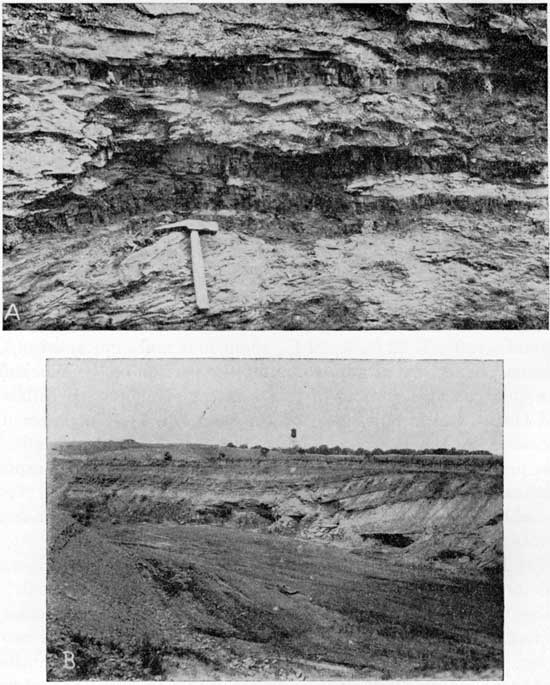
Lower member of Fort Scott limestone--The lower member of the Fort Scott limestone is from 10 to 20 feet thick in southeast Kansas, averaging 13 feet. It is commonly a gray, crystalline, fossiliferous limestone, occurring in beds from a few inches up to 2 feet in thickness. The lower foot or two has a conchoidal fracture, is gray to light brown in color and weathers yellow, and is therefore distinct from the overlying beds. Plate 4-A shows a typical exposure of the lower part of the Fort Scott limestone and also shows its contact with the underlying black shale at the top of the Cherokee.
Plate 4--A, Outcrop of the lower part of the Fort Scott limestone and the upper part of the Cherokee shale on west bank of Neosho River near center of N/2 sec. 4, T. 32 S., R. 21 E. Man stands on the top of black fissile shale between the overlying Fort Scott limestone and the underlying Breezy Hill limestone member of Cherokee which extends about 6 inches below the water; B, Brown chert gravel exposed in pit in SW SE sec. 9, T. 35 S., R. 22 E. Test holes show that the gravel extends over 10 feet below floor of pit; 13-foot stadia rod for scale.
The lower member of the Fort Scott limestone is the so-called "cement rock" from which hydraulic cement is manufactured in the vicinity of Fort Scott.
Six collections of fusulinids that were identified by L. G. Henbest are reported, together with his comments, as follows (numbers refer to collecting localities listed at end of report):
7780, 7783, 7785, 7788, and 7790, Fusulina girtyi; 7784, Fusulina haworthi?.
The lower member of the Fort Scott contains a large number of Fusulina girtyi (Dunbar and Condra) and an abundance of Fusulina haworthi Beede (a synonym of this is F. stookeyi Thompson). The species F. girtyi and F. haworthi are recorded by Thompson from the "18-foot limestone" which lies 18 feet above the Mystic coal in Iowa. In Illinois, F. girtyi (variously called Fusulina ventricosa, Girtyina ventricosa, etc.) has long been recognized as the most generally distributed and the most characteristic fossil of the Brereton limestone. Associated with F. girtyi locally in Illinois is F. haworthti.
The supposition has arisen and is generally accepted that the Brereton limestone of Illinois and the upper member of the Fort Scott limestone are correlative. This supposition appears to have grown from some more or less indefinite records of F. girtyi as having been found in the upper Fort Scott. Judging from the fusulinid collections from Kansas and my numerous collections from Illinois, in conjunction with the restricted range of F. girtyi in Illinois, I would be more inclined to correlate the lower member of the Fort Scott and the Brereton limestone.
Shale between the lower and upper members of the Fort Scott--Between the two limestone members of the Fort Scott is a shale unit from 3 to 7 feet thick. The upper half of this unit consists of black shale with some small concretions, and the lower part consists of gray shale and clay. To the north and east of Crawford County a coal bed occurs between the two members of the Fort Scott, but in the area described in this report it is thin or absent.
Upper member of Fort Scott limestone--The upper member of the Fort Scott limestone is from 13 to 19 feet thick in southeastern Kansas, averaging 17 feet. It is a light-gray to white crystalline limestone, weathering to various shades of gray. The lower few feet weather more rapidly than the overlying part and have a yellow-brown color. In most places it is also thinner bedded than the middle and upper parts. The top 5 feet of the upper member of the Fort Scott consists of nodular and argillaceous limestone that weathers buff. It is seldom exposed, owing either to its lesser resistance to erosion than the underlying beds or to erosion prior to deposition of the Labette shale. The coral Chaetetes milleporaceus is very abundant in the upper member.
Two collections of fusulinids, made from the upper member of the Fort Scott limestone were identified by Henbest with the following comment:
7793, Fusulina sp.; 7794, Tetrataxis sp., Polytaxis sp., Fusulina sp., Fusulina girtyi?.
The collections from the upper member of the Fort Scott contains a new species of small Fusulina which is unlike any I have seen in the upper part of the Fusulina zone. Fusulina girtyi is rare in the upper Fort Scott and is known only in a single old collection from Oswego, Kan., which is reported to be from the upper member of the Fort Scott.
Englevale channel sandstone
(This stratigraphic unit is a basal element of a cyclothem (cyclic sedimentary formation) that forms part of the Labette shale. In the classification of the Kansas Geological Survey, the Englevale is accordingly ranked as a member of the Labette shale.--R. C. Moore.
The channel sandstone for which the name Englevale has been proposed (Pierce and Courtier, 1935) is typically exposed near the town of Englevale, in northeastern Crawford County, Kansas.
The areal distribution of the Englevale channel sandstone is linear, trending north-northwest from Arma for a distance of at least 9 miles (Pl. 1) to the Crawford County line. As fieldwork did not extend beyond Crawford County, data are lacking on its northward extent into Bourbon County. Erosion has removed any traces that may have been present south of Arma. The sandstone belt, as at present exposed, has an average width of about four tenths of a mile, but just southeast of Cato it is somewhat wider.
The Englevale sandstone is younger than the Fort Scott limestone, for the channel in which the sandstone was deposited trenches the limestone; possibly the sandstone is younger than the lower part of the Labette shale, but it was not observed cutting the upper part of the Labette shale or the Pawnee limestone. So far as could be observed, the upper limit of the sandstone is gradational into the lower part of the Labette shale; its base cuts into the Fort Scott limestone and in places rests upon the upper part of the Cherokee shale. Good exposures revealing the channel-shaped cross section of the sand are in the vicinity of Englevale, along the north-south road on the east side of town and along and just north of the east-west road half a mile north of town. In the last-named exposure the base of the sandstone in the lowest part of the channel rests upon limestone about 4 feet, above the base of the Fort Scott, and the sides of the channel transect both the upper and lower limestone members of the Fort Scott. The direction of flow of the stream depositing the sand in the channel apparently was northward, for between Arma and Englevale the lowest statigraphic position of the sandstone is 4 feet or more above the base of the Fort Scott, whereas in the northwest corner of the area the lowest exposed part of the channel lies below the base of the Fort Scott. Crossbedding in the sandstone, according to Straub (personal communication), does not appear to be in a common general direction. Exposures definitely showing the direction of crossbedding are not abundant, however, and if a meandering channel is postulated, a considerable latitude in direction of crossbedding is allowable.
In most places the Englevale sandstone is light-brown in color with reddish-brown specks; it is micaceous, somewhat massive, and crossbedded. Locally the middle part may be darker in color and the lower part slightly shaly. It contains carbonaceous material and some plant impressions, but no conglomerate or fragments of underlying strata were observed. At several places where the base of the sand is exposed, it makes a sharp contact with the underlying Fort Scott.
Channel sands of Pennsylvanian age are not an uncommon feature in Missouri. Two of the large channel sandstones in Missouri, known as the Warrensburg and the Moberly, were described by Winslow (1890) and Marbut (1898) and later studied by Hinds and Greene (1915). The exposed length of each of these channels is over 40 miles, with an average width of 2 or 3 miles and a depth of about 200 feet. The direction of the flow of the stream depositing the sand in the channels is thought to have been toward the north. In regard to the age of the sandstones, Hinds and Greene (1915) say that they are younger than the Cherokee, Henrietta (this includes the Pawnee, Labette, and Fort Scott), or lower part of the Pleasanton (which corresponds to the Bandera shale and overlying formations to the base of the Hertha limestone in Kansas), but have not been seen to cross upper Pleasanton or higher strata. The Englevale sandstone, therefore cannot be correlated with the Warrensburg and Moberly sandstones from the information available. Greene and Pond (1926) correlate their Walker conglomerate and sandstone--a channel-like deposit in Vernon County, Missouri, which rest upon the shale above the Williams coal (Bevier of this report)--as a southern continuation of the Warrensburg channel sandstone. Greene (1926) states, however, that the exact age cannot be determined, as there is no evidence in Vernon County that their Walker formation was ever overlain by other strata. Several other channel sandstones have been noted (Hinds and Greene, 1917) in the Pennsylvanian, but they are all considerably higher in the section than the Englevale sandstone.
During future work on the Pennsylvanian channel deposits of this region the possibility of younger channels either superimposed or near older ones should be kept in mind, for the Englevale channel sandstone indicates that some channel sands were formed prior to the Warrensburg sand.
Labette shale
The shale overlying the Fort Scott limestone was described by Bennett in 1896. In 1898, at the suggestion of George I. Adams, it was named the Labette shale by Haworth and Crane. It is exposed along an irregular line extending southward through Tps. 27 and 28 S., R. 24 E., then southwestward through Girard to the northeast corner of Labette County. From this point to the southwest corner of the area all of the outcrop of the Labette shale lies west of the Neosho River. For the most part, the width of the outcrop is slightly less than a mile, but at several places the Labette shale is the surface formation over areas of several square miles. The shale is much softer than the limestone units immediately above and below it and consequently occupies the slopes and valleys between limestone escarpments and benches. The contact between the Labette shale and the underlying Fort Scott limestone is usually concealed, for in weathering the shale forms a thick soil cover and in addition the upper 5 feet of the Fort Scott limestone weathers more rapidly than the limestone below. Much of the contact shown on Plate 1 is, therefore, based on drill-hole data and on the calculated position of the top of the Fort Scott rather than on actual outcrop observations.
The Labette shale lies conformably on the Fort Scott limestone and is overlain conformably by the Pawnee limestone. It consists principally of gray shale with some beds of sandstone and sandy shale, and a few thin beds of limestone and coal. It is from 50 to 75 feet thick. The Labette shale is seldom well exposed. The most complete section observed lies about 3 miles west of Englevale, where the following section was measured.
| Section of the Labette shale measured along the west line of the SW sec. 15, T. 28 S., R. 24 E. | Feet | |
|---|---|---|
| Pawnee limestone | ||
| Limestone, speckled tan and brown, fossiliferous, brittle, weathers light brown | 1+ | |
| Labette shale | ||
| Shale, black | 1 | |
| Shale, gray to greenish-drab | 9 | |
| Concealed, probably shale containing a thin bed of limestone | 5 | |
| Calcareous claystone, dirty buff, hard, conchoidal fracture | 0.4 | |
| Shale, greenish gray to drab, laminated | 8 | |
| Shale, greenish gray, partly concealed | 10 | |
| Limestone, gray to dark gray, composed mostly of fossil shells; weathers into flaky pieces with straw-colored surface | 0.3 | |
| Coal, lower part carbonaceous shale | 0.3 | |
| Sandstone, bluish-gray, fine-grained, friable | 1.5 | |
| Concealed | 3 | |
| Sandstone, light-gray, micaceous, hard, calcareous, with ripple marks; lower half is in a single bed | 2 | |
| Shale, gray, sandy | 11 | |
| Shale, black, carbonaceous | 0.1 | |
| Shale, gray | 0.3 | |
| Concealed | 5 | |
| Clay-shale, gray, "soapy" | 3 | |
| Concealed, to base of Labette shale | 15 | |
| Total thickness of Labette shale | 75 | |
In Labette County the upper 7 to 8 feet of the Labette shale is mostly black shale with thin beds of light-gray shale underlain by an impure, fossiliferous black limestone 2 to 4 inches thick. Thin lenticular beds of limestone may occur in the black shale and are usually underlain by an inch or two of coal.
Pawnee limestone
The Pawnee limestone was named by Swallow in 1866 from exposures along Indian and Pawnee creeks and southward to Bone Creek. Pawnee Creek heads a few miles northwest of Farlington and flows northward into the South Fork of Marmaton River about 7 miles southwest of Fort Scott. The Pawnee limestone crops out in the western part of Tps. 27 and 28 S., R. 24 E., and also along the divides in the eastern parts of those townships and the southern part of T. 29 S., R. 23 E. West of Neosho River it caps numerous low hills and divides along the western border of the area.
The Pawnee is a light-gray to white, fine crystalline, and somewhat cherty limestone. It is fossiliferous, but less so than the Fort Scott limestone, which it resembles. It contains very few clay or shale partings, is usually thick-bedded, and locally may be massive. In many bluff exposures the massive character is destroyed by vertical and horizontal joints, the latter giving an appearance of thin bedding, whereas when seen in fresh quarry cuts there are actually few thin beds in the Pawnee. A coral-bearing zone was noted about 6 feet above the base of the formation. Also at this horizon coarse chert fragments weather out; the limestone below has more yellow and brown weathering material than above. The average thickness of the Pawnee in this area is about 22 feet.
The base of the Pawnee is not as well exposed as the base of the Fort Scott limestone, but can usually be determined approximately within a few feet. At several places in the northwestern part of T. 31 S., R. 21 E., an 8-inch bed of black shale occurs approximately 26 inches above the base of the formation. The Pawnee lies conformably on the Labette shale and is overlain by the Bandera shale. The top of the Pawnee was not observed within the area shown on Plate 1.
Tertiary or Quaternary Gravels
Deposits younger than Pennsylvanian in age were not studied in detail and are not shown on the map (Pl. 1). The following brief description is based upon a cursory examination of these materials.
Chert pebbles embedded in clays occur on some of the upland in southern and western Cherokee County at altitudes from 820 to 900 feet above sea level. The chert is light gray, buff, reddish brown, or pink in color, and is in various stages, of decomposition, with occasional pieces of chert almost completely altered to clay minerals. The large pebbles are subangular with rounded edges, and the smaller ones are more or less rounded.
Similarly situated deposits in the Joplin area were referred by Smith and Siebenthal (1907) to the Tertiary and called "Lafayette gravels," a name that is no longer used. In describing the upland gravels of Vernon County, Missouri, Greene and Pond (1926) say:
These gravels seem to be identical with those occurring in the Joplin district and to the Tertiary gravels found in Greene county and correlated with the Lafayette gravels of Tertiary age. . . . Criteria for a closer correlation have not been found in Missouri in the area examined, and it appears to the writer that a correlation with Cretaceous, Tertiary, Pleasanton, or Recent deposits elsewhere has no basis.
Smith and Siebenthal (1907) concluded that the gravels in the Joplin area were derived from the Mississippian rocks, because these rocks were nearest at hand and also because Mississippian fossils were found in the chert of the gravels. In the cherts of the upland gravels of southern Cherokee County, both Mississippian and Pennsylvanian fossils were found. The source of these gravels, therefore, is both from the Mississippian limestone to the east and from cherty Pennsylvanian limestones that formerly extended much farther east.
The upland gravel deposits, although they do not cover large areas, are probably remnants of a thin deposit that was formerly of wider extent. Typical exposures may be seen at the following localities: On top of a small hill just south of the center of the east line of sec. 11, T. 35 S., R. 22 E.; SW SW sec. 22, T. 33 S., R. 22 E.; and along the north line of sec. 2, T. 35 S., R. 22 E. Possibly some of the gravel deposits, along the west side of Neosho River should be correlated with the upland gravels.
Quaternary System
Deposits of this district that may unquestionably be referred to the Quaternary period are the soils, alluvium, and those gravel deposits occurring along streams.
Gravel deposits
The gravel deposits that are considered as Quaternary in age occur principally as terraces along the major stream valleys in this district. Gravel terraces along Spring River described by Smith and Siebenthal (1907) are now mainly covered by the waters of the lake formed by the dam at Lowell.
The gravel deposits, along Neosho River are from about 780 to 870 feet above sea level. They are more abundant on the west side of the river. The higher of these gravels, that is, those above 820 feet in elevation, are coarse and consist of white, brown, and red chert, and rest on beds as high stratigraphically as the Pawnee limestone. The gravels on the Pawnee limestone may have been deposited contemporaneously with the upland gravels of southern Cherokee County.
The lower terrace gravels are exploited in many places along the old floodplain of Neosho River. A deposit in the SW SE sec. 9, T. 35 S., R. 22 E., covers several acres and is known to extend to a depth of at least 23 feet (Pl. 4-b). This pit has supplied a considerable amount of gravel for road metal. The gravel is mostly a coarse brown chert, contains very little sand or clay, and is well sorted.
The Quaternary gravels in Labette County contain brown chert, which, in conjunction with their regional location, suggests that they were derived from the chert in the limestones of Pennsylvanian age which now lie to the northwest. The chert gravels in the southeastern part of this district, along Spring River and Shoal Creek, bear a closer resemblance to the cherts in the Mississippian limestone from which they presumably were derived.
Alluvium
The alluvium, as here described, includes both the terrace and present floodplain deposits of streams, for in many places it is difficult to differentiate them. Alluvium occupies the valleys of the larger streams--notably Spring River and Neosho River--and varies in width from less than a quarter of a mile in the smaller valleys to about 4 1/4 miles along Neosho River east of Chetopa.
It is difficult to map alluvial boundaries in this region, for the thick soil cover grades imperceptibly into the alluvium and some of the alluvial filling in preexisting valleys is detectable only from drill records. The alluvium as shown on Plate 1 is sketched from soil maps (U.S. Department of Agriculture, 1914, 1926, 1928) and the Joplin district folio (Smith and Siebenthal (1907) supplemented by field observations. The alluvial boundary, as mapped along Neosho River, represents approximately the high-water limit of the river in flood stage.
The alluvium varies greatly in depth. Along the lower stretches of Neosho River, thicknesses from 15 to 30 feet were observed. Smith and Siebenthal (1907) reported thicknesses up to at least 25 feet along Spring River.
In some places the streams run on rock floor, with banks of alluvium up to 20 feet in thickness, while in others the valleys were cut below present stream level at an earlier period and subsequently have been filled with alluvium and gravel. The alluvium is composed principally of clays and silty clays, and along Spring and Neosho rivers also contains an appreciable content of gravel.
Soils
The soils of this district have been studied in detail by the United States Department of Agriculture in cooperation with the Kansas State Agricultural College (now Kansas State College) (U.S. Department of Agriculture, 1914, 1926, 1928) and the Kansas Agricultural Experiment Station.
The soils may be divided into two main groups: (1) upland, or residual soils, and (2) bottomland, or alluvial soils. Of the residual soils, those derived from limestones may be thin in places, but, if sufficiently thick, are excellent soils for agricultural purposes.
The main sources of the residual soils derived from limestones are the Mississippian limestone in southeastern Cherokee County and the limestones of the Pennsylvanian, namely, Fort Scott and Pawnee, in the northwestern portion of this district. The other upland soils are derived from the shales, sandstones, and thin limestones in the main body of the Cherokee shale. The soils that are derived mainly from shale or from shales and calcareous rocks, with some minor influence from soft, fine-grained sandstones, are considered the best general farming soils of this district. The residual soils vary in thickness from 5 to 18 inches, and the subsoil attains thicknesses of 3 to 5 feet.
The alluvial soils are derived entirely from reworked upland materials. They are subject to frequent floodings and are poorly drained. These soils may attain a thickness of 15 feet. They have a high natural fertility and, with sufficient protection against overflow and installation of adequate drains, would prove a productive and valuable soil, for all crops grown on them do well if not injured by floods.
Prev Page--Geography || Next Page--Structure
Kansas Geological Survey, Geology
Placed on web July 27, 2011; originally published Sept. 1938.
Comments to webadmin@kgs.ku.edu
The URL for this page is http://www.kgs.ku.edu/Publications/Bulletins/24/04_strat.html