| Original published in W.W. Hambleton, ed., 1959, Symposium on Geophysics in Kansas: Kansas Geological Survey, Bulletin 137, pp. 9-52 | ||
Kansas Geological Survey
The article is also available as an Acrobat PDF file.
In Kansas, characteristics of the rock section down to the sub-Paleozoic erosional surface are fairly well known. Rocks constituting this part of the crust are, in this paper, grouped in six divisions for convenience in discussion. These divisions are: Cambrian-Ordovician, Silurian-Devonian, Mississippian, Pennsylvanian-Permian, Mesozoic, and Tertiary-Quaternary rocks. The less well known Precambrian rocks, into which the sub-Paleozoic floor is cut, are included as a seventh division and are by far the greatest part of the earth's crust in Kansas.
Structure of the rocks is revealed by outcrop and subcrop patterns on erosional surfaces, including unconformities and the present land surface.
Petroliferous provinces in Kansas coincide with major post-Mississippian-pre-Desmoinesian rather than earlier structural provinces.
A basic background in geology is necessary for an exploration geophysicist to evaluate his data properly. Inasmuch as most geophysical work at present being conducted in Kansas is of an exploratory nature, it seems fitting to include in this volume a brief resume of Kansas geology. The regional aspects have been known for years, but refinements and details are constantly being brought to light by a never-ending search for underground resources in which geophysics is playing an increasing role from year to year. The value of geophysics, a relatively new tool in applied science, may be estimated by its increased use in oil finding. Of the numerous methods available, seismic exploration has been by far the most successful, because of the solving of many problems by close cooperation between the geologist and geophysicist. Techniques have been devised to minimize many of the effects of geological irregularities that at one time tended to impair the quality of geophysical data. It is hoped that this paper may provide some basic material on which the geophysicist may base future interpretations.
That part of the earth in Kansas about which we have considerable direct information comprises nowhere more than a few thousand feet of rock. The crust is made up of crystalline rocks of Precambrian age of indefinite thickness and a veneer of sediments ranging in thickness from 600 to 9,500 feet. In the following paragraphs these rocks are described briefly; later, structural conditions are discussed. It should be mentioned here, however, that although the total amount of recorded vertical movement is measured in thousands of feet, development of major structures has not sharply modified the original horizontal position of Paleozoic and younger rock layers. The dip of the beds, except in small "pseudostructures" such as those due to slumping into solution cavities, in no place is known to exceed 10 degrees (directly above the Precambrian surface along the east side of the Nemaha Anticline). In outcropping rocks, dips of more than a fraction of one degree are rare.
For convenience of discussion, rocks of Kansas are divided into seven main units. Although these units contain rocks assigned to more than one geological system, each unit is characterized by uniformity of structural attitude and similarity of lithology. Four of these units crop out within the state: (1) Tertiary-Quaternary, (2) Mesozoic, (3) Pennsylvanian-Permian, and (4) Mississippian; the other three, which in Kansas are known only through information obtained by drilling, are: (5) Silurian-Devonian, (6) Cambrian-Ordovician, and (7) Precambrian.
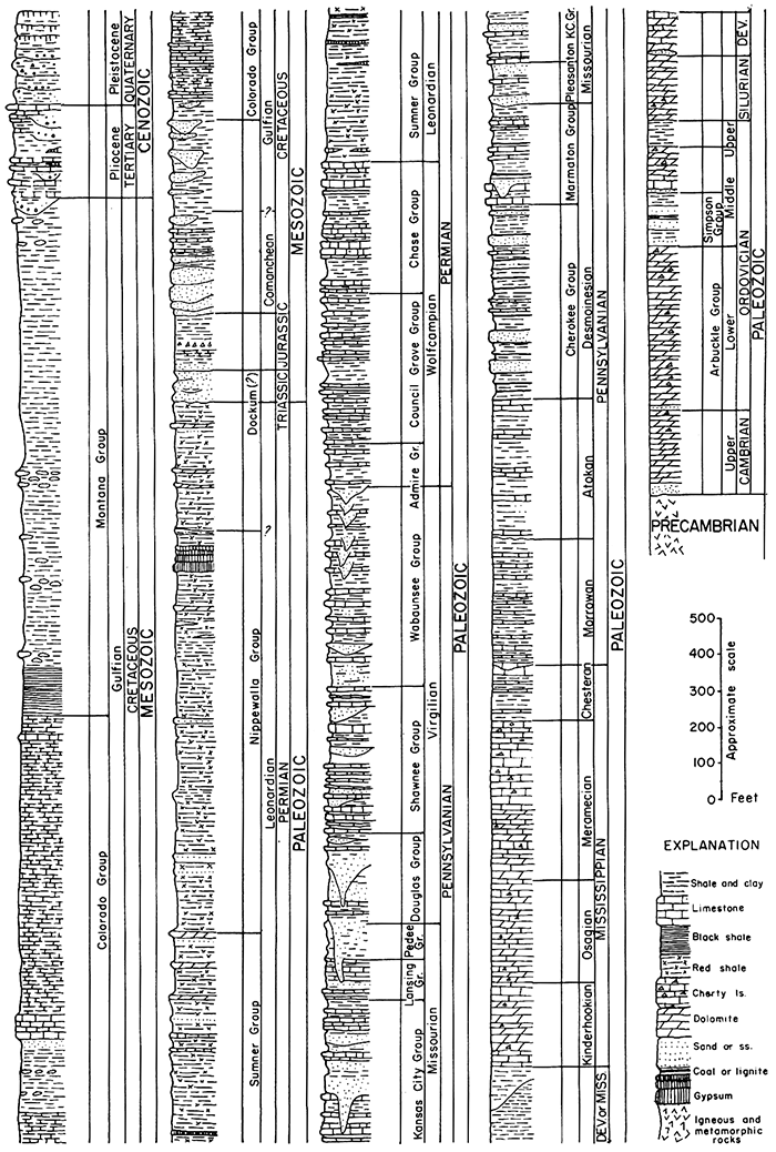
The geologic map of Kansas (Moore and Landes, 1937) shows distribution of outcropping rocks in Kansas; classification and a brief description of Kansas rocks are given by Moore, Frye, and Jewett (1944), and Moore and others (1951, 1952). Regional or local descriptions of Kansas rocks are found in many other reports. Distribution of different rock units in the state is shown by a generalized geologic map (Fig. 1); stratigraphic sequence is represented by a composite section of rocks present in Kansas (Fig. 2). Following are brief summarizations of the general nature of the seven rock divisions.
Figure 1--Generalized geologic map of Kansas. Older bedrock formations are exposed progressively eastward. Seven small igneous bodies crop out in Riley and Woodson Counties.
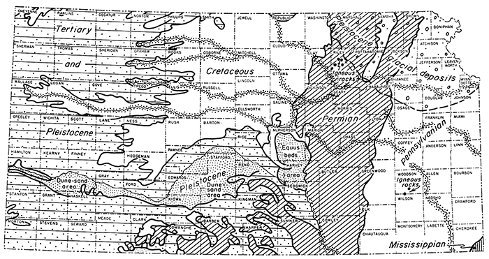
Figure 2--Composite stratigraphic section of rocks present in Kansas. Beds older than Mississippian are known in the state only in the subsurface (modified from Moore and others, 1952). [An Acrobat PDF version of this figure is available.]
Quaternary (or Pleistocene) deposits in Kansas are more widespread than indicated on the geologic map of the state (Moore and Landes, 1937). Even disregarding soils, properly classifiable as Pleistocene sediments, much of the land surface in Kansas is underlain by Pleistocene deposits. Most of these deposits (loess, alluvium, dune sand, and in northeastern Kansas, glacial deposits) are unconsolidated. They are generally less than 100 feet thick, but locally form a masking blanket 500 feet thick or more.
Tertiary formations, widespread in western Kansas, resemble the. Quaternary in their blanketing relations to older strata and their incomplete consolidation. Deposits of probable Tertiary age are widespread in eastern Kansas also, but relatively thick Tertiary deposits are confined to the western part of the state, where they attain a thickness of about 400 feet. Kansas Quaternary sediments are described by Frye and Leonard (1952), Tertiary rocks by Frye, Leonard; and Swineford (1956).
The Mesozoic is represented chiefly by Cretaceous rocks. Strata of Cretaceous age are spread across all of western and northwestern Kansas and extend as far east as parts of central Kansas. Maximum thickness in Kansas occurs near the northwestern corner of the state, where some wells penetrate nearly 3,000 feet of these beds. Cretaceous rocks, for the most part, consist of brown ferruginous sandstone, dark clayey shale, and chalky limestone. Jurassic and Triassic rocks lie below the Cretaceous in parts of western Kansas, and elsewhere Cretaceous deposits lie unconformably on various Permian formations; north of Kansas they overlap onto Precambrian. Thus the division is set apart structurally from older rocks. Jurassic rocks, which attain a thickness of about 350 feet, are present west of a line extending from Smith County in north-central Kansas to Morton County in the southwest corner. They consist of shale, sandstone, and limestone, but include minor amounts of chert and anhydrite. Triassic rocks (Moore and others, 1951) occur only in the extreme southwestern part of the state, in parts of Morton, Stanton, and Hamilton Counties. These rocks are redbeds that are difficult to differentiate from underlying Permian deposits. Triassic beds are locally as much as 320 feet thick. Mesozoic rocks in the subsurface of western Kansas have been described by Merriam (1957), the Jurassic by Merriam (1955), and the Triassic by McLaughlin (1942). Other references to Mesozoic rocks in the state include Bass (1926), Elias (1931), Frye and Brazil (1943), Latta (1946, 1948), McLaughlin (1943), Plummer and Romary (1942), Rubey and Bass (1925), and Twenhofel (1924).
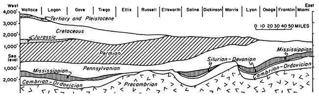
Lying unconformably below the Mesozoic is a great thickness of upper Paleozoic strata included in the Permian and Pennsylvanian Systems. These rocks, which are older than the Mesozoic beds above them, have an entirely different structure and are separated by an important unconformity from still older rocks. Permian and Pennsylvanian rocks constitute a structural unit ranging in thickness from a featheredge in southeastern Kansas, where the sequence has been beveled by erosion, to somewhat more than 6,000 feet in southwestern Kansas. These rocks are exposed in east-central and eastern Kansas, where the dip is gently westward except as modified here and there by dips in other directions. In eastern Kansas, westward dip definitely is interrupted by the Nemaha Anticline (Fig. 3).
Figure 3--Generalized east-west cross section of Kansas rocks. Major postMississippian structural provinces revealed include (from east to west) Forest City Basin, Nemaha Anticline (under Morris County), Salina Basin, Central Kansas Uplift (under Ellsworth, Russell, and Ellis Counties), and Hugoton Embayment. Note that younger rocks are not affected by these structures.
Most of the upper and middle Permian rocks (mostly redbeds and evaporites) in Kansas are believed to have been deposited in a shallow marine basin (Swineford, 1955). On the outcrop the strata are mainly shale and siltstone, many of them red and therefore commonly referred to as Permian redbeds. Beds of anhydrite and gypsum are not uncommon, but because of their solubility; not all of them crop out. A few thin but persistent beds of dolomite occur in the redbed part of the Permian section.
The Stone Corral formation (Cimarron anhydrite of subsurface terminology), in the Permian Leonardian Series (Fig. 2), is a useful marker bed in subsurface investigations. Stratigraphically higher, the Blaine formation (principally anhydrite also) is a useful marker in the subsurface. Both the Blaine and the Stone Corral produce good seismic reflections.
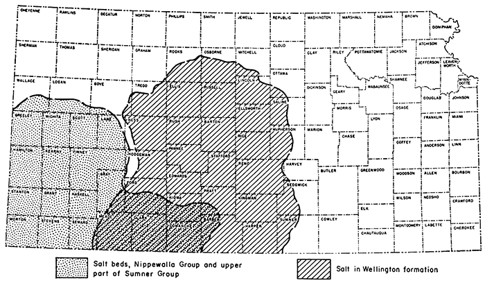
In another paper in this symposium, Kulstad discusses the Permian Wellington salt deposit of the Leonardian Series (Fig. 2); however, presence of thick salt accumulations in younger parts of the Permian section in southwestern Kansas also should be mentioned Approximate areas in the state underlain by salt are shown in Figure 4. Distribution and other details of salt beds in the Wellington formation are known with greater accuracy than distribution of younger salt deposits.
Figure 4---Sketch map showing approximate areas in Kansas underlain by Permian salt beds.
In southwestern Kansas four or more relatively extensive salt deposits occur in the Permian stratigraphically above the well-known Wellington salt. These are a part of a large assemblage of salt beds extending far to the south and west into Oklahoma, Colorado, Texas, and New Mexico. Their stratigraphic position can best be described in reference to the Stone Corral and Blaine formations, both easily recognized on electric logs and in well samples.
Thick salt deposits underlie the Stone Corral formation over a large area. These beds, which are in the upper part of the Ninnescah shale, are in many places more than 200 feet thick, and in a part of Clark County most of the Ninnescah section seemingly is salt. Depth to this salt is about 1,250 feet below the land surface in Kiowa County, about 1,000 to 1,500 feet in Clark County, and about 1,600 feet in Meade and Gray Counties. Over a large area in southwestern Kansas a saliferous shale lies between two anhydritic beds of the Stone Corral formation (Merriam, 1957a). Locally this part of the formation seems to be entirely salt. Salt-bearing beds about 200 feet thick have been logged in the Harper formation, next above the Stone Corral, at depths ranging from about 1,100 to 1,550 feet in Gray and Meade Counties. In Clark County a 300-foot salt section, seemingly in the Salt Plains formation, is found at depths ranging from 650 to 1,000 feet, and in Seward County the same salt bed lies at a depth of 1,300 to 1,400 feet.
Salt in the Flowerpot formation, a short distance below the Blaine formation, lies at a depth of about 450 feet in parts of Clark County, about 1,000 feet in Gray County, 950 feet in Seward County, 1,000 feet in Morton County, 1,250 feet in Stanton County, and 1,100 feet in Hamilton County. Although individually the salt beds are not thick, collectively they are of utmost, importance because locally the thickness of the salt changes abruptly, especially near margins of the deposits.
Beds forming approximately the lower 800 feet of Permian rocks in Kansas (rocks of the Wolfcampian Series) are mainly of marine origin; they are similar in many respects to the Pennsylvanian rocks that except locally lie conformably below. The lower Permian deposits and outcropping Pennsylvanian beds consist mostly of alternating layers of shale and limestone. There are a few sandstone and coal beds in the Permian, but lenticular or channel sandstone bodies make up a considerable part of the Pennsylvanian section, and coal is characteristic of most parts of the sequence. Coal mines in Cherokee rocks are common in the outcrop area in southeastern Kansas, and some now abandoned shafts reached Cherokee coal beds in the Leavenworth-Atchison area in northeastern Kansas. Younger coal beds are mined in Bourbon, Linn, and Osage Counties.
Divisions of Pennsylvanian rocks assigned to different series (Fig. 2) are separated, especially in the outcrop area, by unconformities that may represent lapses of considerable time in the record. Although lateral continuity of lithology and almost uniform thickness of stratigraphic units are characteristic of lower Permian and Pennsylvanian rocks in Kansas, abrupt changes are not uncommon (Jewett and Muilenburg, 1957).
Lower Pennsylvanian rocks occur in the subsurface of the Hugoton Embayment in southwestern Kansas according to Moore (1949) and Thompson (1944). These rocks have been assigned to the Morrowan and Atokan Series principally on the basis of their fusulinid fauna. Moore (1949, p. 30) shows the general distribution of rocks of Morrowan and Atokan age encountered in wells. The pre-Desmoinesian rocks seemingly are marine and consist of alternating limestone and shale. The maximum thickness is about 850 feet (Moore and others, 1951, p. 102).
Other useful references on rocks of Permian and Pennsylvanian age include Howe (1956), Jewett (1954), Moore (1936), Moore, Frye, and Jewett (1944), Moore and others (1951a), O'Connor and others (1953, 1955), and Swineford (1955).
A small part of southeastern-most Kansas contains outcrops of Mississippian rocks, but strata of Mississippian age are widely exposed in neighboring areas. The outcrop area in extreme southeastern Kansas is part of the Tri-State zinc and lead mining district, where there are numerous underground workings. These rocks constitute a stratigraphic-structural division in Kansas and are commonly designated by drillers as "Mississippi lime". Mississippian rocks are characterized by the dominance of limestone in the deposits, and they are set apart structurally by prominent unconformities at the top and base. Most information about Mississippian rocks in Kansas has been obtained from well data, and it has been made known especially through the work of Lee (1939, 1940, 1943, 1956). The surface of Mississippian rocks in eastern Kansas is inclined gently westward but in northwestern Kansas is inclined southeastward. The greatest depression on the Mississippian surface is along the Oklahoma line in southwestern Kansas. Mississippian rocks are absent from crests of some major uplifts. Absence of some lower Mississippian formations may be due in part to nondeposition, but their thinning and complete removal from major structural features is the result of uplift and erosion prior to Pennsylvanian sedimentation. Thickness of Mississippian rocks exceeds 1,000 feet in southwestern Kansas; thickness of a few hundred feet is more common in the rest of the state.
In places in Kansas, Mississippian limestone is underlain by a sequence of shale assigned to the Boice formation and Chattanooga formation. Separately and collectively, these units, which are believed to be disconformable one to the other, sometimes are called "Kinderhook shale". According to Moore and others (1951, p. 111) the maximum known thickness of the Boice shale, probably of Mississippian age, is 110 feet; the Chattanooga, probably of Devonian age, 250 feet.
Rocks, predominantly limestone and dolomite, of Devonian and Silurian age lie unconformably below the Mississippian and unconformably on Ordovician rocks. In places they overlap different Ordovician formations, but in general, their structural attitude and distribution accords more closely with Ordovician than with Mississippian rocks. These commonly undifferentiated rocks are known as "Hunton"; however, Lee (1956) has shown that a disconformity separates Devonian and Silurian rocks. Like Mississippian rocks, the "Hunton" has been removed by erosion from the highest parts of the Nemaha Anticline, Central Kansas Uplift, and Chautauqua Arch; elsewhere in northeast Kansas (the North Kansas Basin), these rocks are present and attain a maximum total thickness of 650 feet. "Hunton" rocks are not known to be present elsewhere in the state except in the northern part of the Sedgwick Basin in Harvey County and in parts of McPherson, Marion, Sedgwick, Butler, and Reno Counties. Small outliers of "Hunton" are known beyond the larger areas of occurrence (Lee, 1956).
A sixth rock division comprises all Paleozoic rocks older than Silurian; these lie above a great unconformity at an erosion surface cut into Precambrian crystalline rocks. The division consists chiefly of dolomite but includes some limestone and sandstone; the rocks are Ordovician and Cambrian in age. Well-known subdivisions are Maquoketa (Sylvan) shale, Viola (Kimmswick) limestone, Simpson group (including St. Peter sandstone), "Arbuckle group," Eminence dolomite, Bonneterre dolomite, and Reagan sandstone. The last three formations are of Late Cambrian age. The combined thickness of rocks in this division is about 1,500 feet, but in many places thinning due to retarded rate of sedimentation, nondeposition, or erosion leaves only a few hundred or a few score feet of these rocks. They, along with other Paleozoic formations including some of middle Pennsylvanian age, are absent from higher parts of the Nemaha Anticline, Central Kansas Uplift, and Cambridge Arch.
Precambrian rocks in Kansas, as fat' as known, comprise a metamorphic group that has been intruded by a suite of igneous rocks. Important contributions to the knowledge of these buried rocks recently have been made by Farquhar (1957, p. 53), who writes:
"The metamorphic group consists mainly of quartzite, granulite, schist, phyllite, and gneiss. Impure marble has been reported in two places. Some of the gneiss is metasedimentary, and some is foliated 'earlier' granite, injected about the time of regional metamorphism. The intrusive suite is composed mostly of Precambrian 'later' granite, but a few wells near the center of the state encounter gabbro and syenite, probably also Precambrian in age. Widely scattered minor intrusives include diabase and pegmatite."
Configuration of the Precambrian surface is discussed in another section of this paper.
Igneous rocks are exposed in small outcrops in Riley and Woodson Counties (Fig. 1). In Riley County in northeastern Kansas, five small plug-like intrusions of basic igneous rock crop out in an area of lower Permian sedimentary rocks. The rock is peridotitic and contains abundant inclusions of slightly altered sedimentary rock. In Woodson County at Rose Dome, coarse-grained granite crops out seemingly in a small dike covering about 40 acres. Rocks of Missourian age are slightly arched in the area surrounding the granite outcrop; slight alteration of the sedimentary rock is evident. Also in Woodson County, at a locality known as Silver City a few miles south and west of the granite exposure, peridotitic igneous rock is exposed along with fine-grained quartzite derived from sandstone of the Douglas group (Virgilian, Pennsylvanian). Metamorphic rock derived from dark carbonaceous shale and impure limestone is exposed at the same place. Here, too, surrounding strata are slightly arched.
Age of outcropping igneous rocks in Kansas is unknown. [Note: Recent thermoluminescence studies by William C. Pearn (personal communication October 23, 1958) indicates an early Tertiary age for the Silver City intrusive.] Because the Riley County basic rocks are fine grained and contain inclusions of the adjacent sediments that are not greatly altered, it seems probable that molten material solidified under no great thickness of rocks. Because of vulcanism elsewhere believed to be of Cretaceous age, it has been postulated that these igneous rocks in Riley County are Cretaceous. It is believed that the pre-Cretaceous and early Cretaceous land surface in eastern Kansas was at about the same position in relation to lower Permian strata as it is now; hence a few hundred feet of Cretaceous sediments may have been the only cover originally above the intrusion; igneous material may even have reached the surface. Granite at Rose Dome is coarse grained and probably cooled under a considerable thickness of rock. It is also probable that the peridotite at Silver City solidified under a thick cover, possibly including Cretaceous sediments as well as Permian and Pennsylvanian.
References on Kansas igneous and metamorphic rocks include Dreyer (1947), Jewett (1941), Knight and Landes (1932), Moore and Haynes (1920), Twenhofel and Edwards (1921), and Wagner (1954).
Extensive surfaces of erosion are the keys to understanding structural geology of large segments of time and space. Distribution of rocks and their thicknesses at interfaces of unconformities (and at the present land surface) are more important in this respect than is the mere attitude of strata in reference to horizontal planes.
The Precambrian surface in Kansas is nearest the present land surface and highest above sea level in Nemaha County, northeastern Kansas, and lowest at a point near the southwestern corner of the state. The relief of the Precambrian surface in the state is shown in Figure 5.
Figure 5--Contour map showing relief of Precambrian surface in Kansas, contour interval 500 feet, sea level datum (from Farquhar, 1957). Configuration of contours reveals Nemaha Anticline extending from Nemaha County southwestward to Cowley County. Central Kansas Uplift (in Russell, Ellis, Barton, and Rush Counties) and Cambridge Arch (Norton and Decatur Counties) are other prominent major "highs."
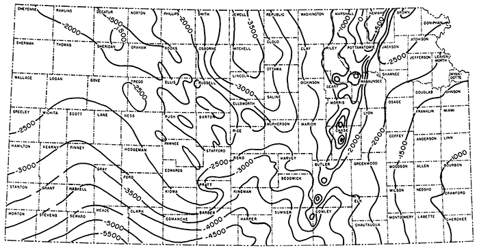
The Precambrian surface (Fig. 5), as the term is used here, refers to the present surface on Precambrian rocks, and not to a surface that existed in Precambrian time; perhaps none of it is of pre-Paleozoic age. On higher parts of uplifts, Precambrian rocks were being eroded as late as middle or late Pennsylvanian time.
Farquhar (1957) found that the oldest known rocks in Kansas, a metamorphic group, comprise mainly quartzite, granulite, schist, phyllite, and gneiss; there is some impure limestone or marble. Schist, gneiss, and quartzite are believed to have been converted into their present rock types from sandstone and shale. These were intruded by granite that is now granitic gneiss. Later, as shown by Farquhar (1957, p. 64), these metamorphic rocks again were intruded by igneous rocks including granite.
It is inferred that the metamorphism that converted very ancient sediments into quartzite, schist, and other altered rock types took place under a deep cover. Granite, and granite that later became gneiss, now on the Precambrian surface must have been originally deep in the earth's crust. The rocks that covered the granite in Precambrian time are not the cover that now lies above the basement. Prior to accumulation of Paleozoic sediments, erosion removed thousands of feet of igneous and metamorphic rocks. The removal of rocks represented by the sub-Paleozoic unconformity required a long time, possibly more than a billion years. What became of the sediments produced by Precambrian erosion is one of the mysteries of geology.
Cambrian, Ordovician, Silurian, and Devonian sediments accumulated above the Precambrian surface. These rocks are chiefly dolomite and limestone, but include some clastic deposits. The carbonate rocks were in part rendered porous by dolomitization and during time of exposure were modified by weathering. Deposition of the sequence was interrupted from tune to time by uplift and exposure, resulting in many unconformities. There are two outstanding unconformities during whose formation older rocks were regionally tilted at low angles and beveled. One was developed before Simpson deposition and the other was formed between the time of accumulation of Silurian and Devonian parts of the "Hunton" (Wallace Lee, personal communication, 1958).
Lee (1956) has shown that the Simpson group (including the St. Peter sandstone) is an important marker or reference zone. The Simpson lies in the basal part of the section of rocks regarded as middle Ordovician in age (Fig. 2). According to Lee (1956, p. 18, 133) two large structural features were developed by pre-Simpson deformation.
A structure named the Southeast Nebraska Uplift by Lee (1943) and later called the Southeast Nebraska Arch developed in southeastern Nebraska and northeastern Kansas before Simpson deposition. In Kansas the area of uplift includes all or parts of Marshall, Pottawatomie, Washington, Riley, Nemaha, and Jackson Counties. Data indicate preSimpson elevation of the area, beveling of uplifted formations, and deposition of Simpson rocks on Precambrian granite on the crest and across the truncated older Arbuckle rocks on the flank of the uplift. Part of the granite area was re-exposed in pre-Pennsylvanian time, but the relative amounts of erosion of granite during these periods of exposure is not determinable.
Lee (1956, fig. 2A) shows a "pre-St. Peter syncline" plunging southward from Russell and Barton Counties. The configuration of the structural pattern is revealed by the 500-foot thickness line of Arbuckle rocks. No geographic name has been assigned to this structure.
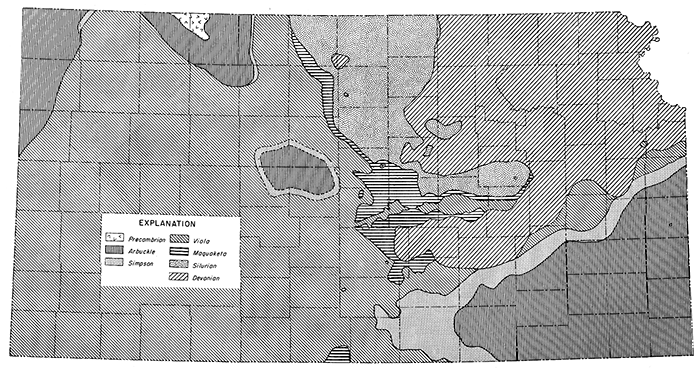
Figure 6 shows distribution of rocks on a surface directly below Chattanooga shale, or where Chattanooga (or Boice) shale is absent, next below Mississippian limestone. No Mississippian or Chattanooga rocks remain on the northern part of the Nemaha Anticline, on isolated areas farther south along the crest of the uplift, or on the Central Kansas Uplift, structures that are post-Mississippian in age. The distribution of rocks on the pre-Mississippian surface in these areas is therefore inferential. It is probable that in the area of the Ellis Arch the post-Devonian-pre-Mississippian outcrop of Arbuckle rocks was similar in shape but of less area than the pre-Pennsylvanian outcrop of Arbuckle rocks in the same area.
Figure 6--Distribution of rocks on surface below Chattanooga shale or inferred position in pre-Chattanooga time where Chattanooga is absent (in part from Lee and Merriam, 1954a; Lee, 1956; and Merriam, 1955a). Subcrop pattern of Simpson Group outlines Chautauqua Arch (southeast Kansas), Ellis Arch (Ellis, Russell, Barton, and Rush Counties), and Cambridge Arch (Norton and Decatur Counties).
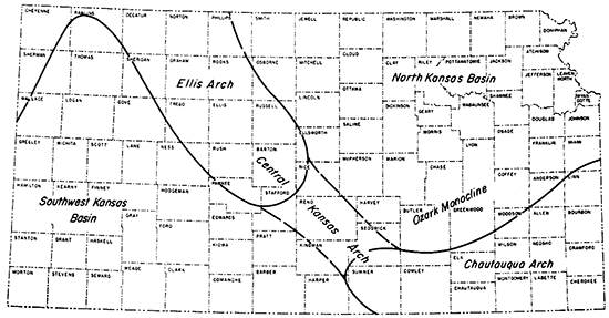
Crustal movements prior to deposition of Mississippian rocks or, in eastern Kansas, before accumulation of Chattanooga shale had marked effects on Kansas geology. The main structural features recorded in the pattern of pre-Mississippian and pre-Chattanooga outcrops are: Chautauqua Arch, Ellis Arch, North Kansas Basin, and Southwest Kansas Basin. Central Kansas Arch is a name sometimes used for the combined Ellis and Chautauqua Arches and the connecting relatively lower, but nevertheless positive, element between the arches (Fig. 7).
Figure 7--Pre-Mississippian structural provinces of Kansas.
A map (Fig. 6) showing the inferred areal geology in Kansas in pre-Chattanooga time indicates a broad area of Arbuckle outcrop in southeastern Kansas, flanked on the northwest by outcrop belts of successively younger formations of Ordovician age trending northeast. Actually the structure indicated is the westward extension in eastern Kansas of the Ozark Dome. Ordovician and Cambrian rocks on its flanks form what has been called the Ozark Monocline (Rich, 1933, p. 796). The exact thickness of post-Arbuckle Ordovician rocks and rocks of Silurian and Devonian age removed by pre-Chattanooga erosion is uncertain, but it amounted to hundreds of feet on the crest. Weathered Arbuckle rocks on low anticlinal folds provide oil reservoirs in several places on the Chautauqua Arch. All known oil pools of this type in the area are below a cover of Chattanooga shale.
The North Kansas Basin, which extends into Nebraska, occupies a large area north of the Chautauqua Arch. Because of downwarping of the area, Silurian and Devonian rocks in this basin escaped removal when the uplifted Chautauqua Arch was beveled by prolonged erosion. The North Kansas Basin area now is traversed by the younger Nemaha Anticline, but it is believed that Silurian and Devonian strata originally extended uninterruptedly across it. The structural relation of pre-Mississippian rocks in northeast Kansas and in northwest Missouri first indicated a structure for which the name Forest City Basin was used (Jewett, 1951, p. 136).
The Ellis Arch was the ancestral Central Kansas Uplift. Compared with the contemporaneous Chautauqua Arch, uplift of the Ellis Arch seemingly was small, but the arch was high enough to restrict distribution of Chattanooga shale toward the west. Rejuvenation of the Ellis Arch (Central Kansas Uplift) resulted in an enlarged anticlinal area of much greater structural relief.
Before leaving discussion of the Ellis Arch it seems desirable to note the connection between the Ellis Arch and the contemporaneous Chautauqua Arch as elements of a larger curving feature that has been called the Central Kansas Arch (Rich, 1933, p. 796, fig. 2). The Central Kansas Arch must not be confused with the Central Kansas Uplift, the rejuvenated post-Mississippian Ellis Arch.
Some of the higher elements of the younger Nemaha Anticline such as the Burns Dome seemingly lie on the extension of northwest-trending anticlinal folds on the Central Kansas Uplift. It has been assumed that similar structural features were developed in pre-Mississippian time. Inasmuch as the Ellis Arch had only minor structural relief in pre-Mississippian time (Lee, 1953, fig. 2A), it seems probable that secondary anticlinal folds upon its crest were also minor, but there seems to be no means of differentiating the early deformation of secondary folds from the more pronounced movements of the rejuvenated structure.
Merriam (1955a) made no distinction between the Hugoton Embayment and the Southwest Kansas Basin (as defined by Moore and Jewett, 1942). The accumulated thickness of pre-Mississippian rocks in the basin indicates that the area properly is designated as a major depressional feature and may be regarded as ancestral to the Hugoton Embayment.
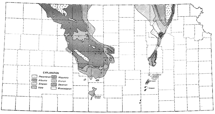
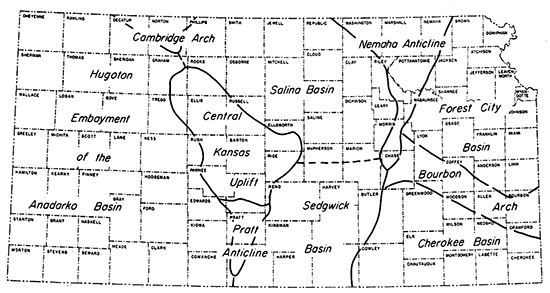
Crustal movement and erosion after Mississippian time resulted in development of the sub-Pennsylvanian surface. The tectonic movements determined the strike and dip . of rocks cropping out on that surface, and the great structural features pictured in the outcrop pattern (Fig. 8) are the main structural and petroliferous provinces in Kansas.
Figure 8--Distribution of rocks on surface below Pennsylvanian beds (in part from Lee, 1956; and Merriam, 1955a). Mississippian rocks are present over much of state except on Nemaha Anticline, Central Kansas Uplift, Cambridge Arch, and Pratt Anticline, where Precambrian rocks underlie this surface.
Some of these structural elements inherited a few of their attributes from earlier tectonic activity, but in the main they seemingly originated in crustal disturbances that occurred in prePennsylvanian and early in Pennsylvanian (post-Morrowan-pre-Desmoinesian) time. The dominant positive structures are the Central Kansas Uplift and the Nemaha Anticline. The highest parts of the two structures were not buried until late Pennsylvanian time.
The Central Kansas Uplift occupies about the same area in Kansas as does the older Ellis Arch (Fig. 7,9). The uplift is the largest positive area in the state and covers an area of approximately 5,700 square miles. The structure is entirely within Kansas.
A maximum section of 5,000 feet of sedimentary rock is present over the Precambrian basement complex of the structure. On the flanks, pre-Pennsylvanian strata are truncated, and locally on the crest completely removed, and overstepped by Pennsylvanian beds. A fairly representative section of Permian rocks, including the Hutchinson salt and other evaporite deposits, extends across the uplift. Lee (1956) cites an interesting case of salt flowage in Rooks County, where salt flowed plastically, it is believed, toward anticlinal areas, probably after Permian time.
The Precambrian complex on the Central Kansas Uplift consists of a variety of igneous and metamorphic rocks. Information is available in this province because many wells have been drilled to the crystalline rocks. Many buried hills of Precambrian age are known and some of these in Barton County have been described by Walters (1946). Structures along the crest and flanks of the uplift are small but important.
Some further references on the geology of the Central Kansas Uplift are Barwick (1928), Koester (1935), Lee, Leatherock, and Botinelly (1948), McClellan (1930), and Morgan (1932).
Walters (1946) described in detail the pre-Pennsylvanian surface in northeastern Barton County, which is of special interest and importance because it illustrates the character of the surface in the central area of uplift. Now hidden beneath a cover of several thousand feet of Pennsylvanian and younger rocks are sinkholes, valley sinks, and solutional valleys that formed on an exposed surface of Arbuckle rocks, probably in Pennsylvanian time. The sinks are filled mainly with Pennsylvanian material, but presence of untransported residual weathered products of dolomite in the lowest part of the depressions indicates that the valleys as well as the sinkholes are solutional features. Some sinkholes reported in areas of intense drilling are more than 150 feet deep. The solutional features have been found to be barren of petroleum although much oil occurs in adjacent rock. Glover (1953) outlined the problem of buried karst topography in relation to seismic studies and noted that because of a "draping" effect of beds over sinks, a "Lower Kansas City" reflection revealed presence of sinkholes.
The Nemaha Anticline, extending across Kansas from an area near Omaha to the vicinity of Oklahoma City, is of great interest. As far as subsurface structures are known, it is unique as a narrow, single anticline of great length. Throughout most of its length it is much steeper on the east flank than on the west.
Since 1914 when oil was discovered at Augusta in Butler County (Berry and Harper, 1948), the anticline has been subjected to intensive exploration. Permian rocks extend over the crest of the anticline on the surface, except in northeastern Kansas and parts of Nebraska where there is an inlier of Pennsylvanian rocks. Reversal of dip over the crest of the anticline can be observed in surface rocks.
Lower Paleozoic rocks were. stripped from the crest of the anticline by pre-Pennsylvanian erosion and were beveled in several areas north of northern Butler County; Pennsylvanian sedimentary rocks directly overlie crystalline Precambrian rocks or truncated pre-Pennsylvanian rocks in northeastern Kansas. During the early part of the Pennsylvanian, the Precambrian was exposed as a low ridge or chain of hills, which shed some sediment into adjoining basins. In Nemaha County, Pennsylvanian rocks less than 600 feet thick lie on Precambrian rocks on the crest of the anticline, but southward the thickness of sedimentary cover increases. Along the crest near the Oklahoma-Kansas line sedimentary rocks are about 4,000 feet thick. There is some evidence that the steeper, east flank of the Nemaha Anticline is locally faulted.
The famous El Dorado and Augusta oil fields in Butler County lie on the Nemaha Anticline. In these fields the chief producing zone (called "Varner" at Augusta and "Stapleton" at El Dorado) is weathered rock below the pre-Pennsylvanian surface. Several other pools, mostly on the western flank of the uplift in its southern part, have yielded great quantities of oil from Ordovician, Mississippian, and Pennsylvanian strata.
The Precambrian rocks encountered in most wells on the Nemaha Anticline are granite, which commonly is deeply weathered. Metasediments have been penetrated by some bore holes.
Thinning of Cherokee sediments in a narrow area extending northwestward from Bourbon County to Lyon County indicates that eastern Kansas was briefly separated into two depositional basins, the Forest City Basin in the north and the Cherokee Basin in the south. The low separating structure expressed in pre-Pennsylvanian rocks is known as the Bourbon Arch (Fig. 9). The Forest City Basin extends into northwestern Missouri, southeastern Nebraska, and southwestern Iowa. In Kansas, Pennsylvanian sedimentation seemingly began earlier in the Forest City Basin than in the Cherokee Basin, but the latter is the northern or Kansas part of a sedimentational area that extended from eastern Oklahoma, and the Oklahoma part contains Pennsylvanian sediments that are older than any in eastern Kansas.
Figure 9--Post-Mississippian structural provinces of Kansas.
The Nemaha Anticline marks the west boundary of the two basins. Although the separating Bourbon Arch may have been an area of meeting of sediments from southerly and northerly directions later in Pennsylvanian time, in general the Forest City and Cherokee Basins. may be regarded as one continuous structural province of great longitudinal extent.
Thus it is seen that for a very brief time the Bourbon Arch separated two areas accumulating sediments, but it should be remembered that in middle and late Pennsylvanian time sediments were being deposited over a vast area in middle North America. Although there were temporary divides here and there, it is misleading to place too much emphasis on individual basins.
The synclinal area in the western part of the combined structure is of special interest. In the north this is called the Brownville Syncline (Condra, 1927, p. 17), and although the name Walnut Syncline (Fath, 1921, p. 66) has been given to part of the same structure in Butler County, a single name may well be applied throughout the entire length of the structure (Jewett, 1951, p. 122). The Davis Ranch oil pools (Smith and Anders, 1951) and other pools in Wabaunsee, Morris, Lyon, and Nemaha Counties are on en echelon folds in the Brownville Syncline parallel to the Nemaha structure (Jewett, 1951a).
Farther south, as in Cowley County east of the anticline, there are several en echelon folds from which oil is produced. These anticlines are recognizable in outcropping rocks but are more pronounced in the subsurface (Bass, 1929).
In the Forest City Basin, sedimentary beds not more than 4,000 feet thick overlie crystalline Precambrian rocks in the Brownville Syncline; 2,500 feet is about average thickness in the basin. Most of these rocks were deposited in the older North Kansas Basin. On the Bourbon Arch, near the Kansas-Missouri line, Precambrian rocks are reached at a depth of about 1,500 feet. In the southeastern corner of Kansas, Mississippian, Chattanooga, and Arbuckle rocks about 1,500 feet thick lie above the crystalline floor, but in the deeper part of the Cherokee Basin, in Cowley County, Permian, Pennsylvanian, Mississippian, and Cambro-Ordovician rocks 5,500 feet thick cover basement rocks.
The Salina Basin' (Fig. 9) lies between the Nemaha Anticline and the Central Kansas Uplift. The greatest thickness of Mississippian rocks is in the western part adjacent to the Central Kansas Uplift. Pennsylvanian sediments were laid down in the Salina Basin after Mississippian strata had been peneplaned, therefore sediments older than Pennsylvanian must have been deposited in an earlier basin. Detailed studies of stratigraphic and structural conditions in the Salina Basin have been made by Lee, Leatherock; and Botinelly (1948) and Lee (1956).
The basin is the second largest in the state, extending over an area of about 12,700 square miles. Cretaceous rocks now cover the western part of the basin, whereas Permian beds are exposed on the east side. The axis of the basin seems to be recognizable in Cretaceous rocks slightly east of the position indicated by the Pennsylvanian-Permian beds and slightly west of the position on the Precambrian surface. The east and west flanks of the basin are sharply delineated, but the southern end is somewhat obscure. Small structures of importance in the basin include the Abilene Anticline, northern part of the Voshell Anticline, and others--parallel to the Nemaha Anticline.
Sedimentary rocks present in the basin include formations of Cambrian, Ordovician, Silurian, Devonian, Mississippian, Pennsylvanian, Permian, Jurassic, Cretaceous, and Tertiary age. The maximum section encountered is about 4,500 feet thick. It should be noted, however, that post-Permian and pre-Pennsylvanian rocks are assigned to the Salina Basin only geographically. The Salina Basin before Pennsylvanian time and after Permian time was a part of other structural provinces. In the southwestern part of the basin, presence of the Hutchinson salt member of the Wellington formation (Permian) is of special interest. The northern and eastern limits of this deposit extend from Rooks County through Osborne, Mitchell, Lincoln, and Saline Counties to McPherson County.
The Precambrian basement complex beneath the Salina Basin consists mainly of metamorphic rocks; granitic rocks are also present. One well in Clay County encountered diabase. This is the only known occurrence of this type of rock in the state. In Riley County, in the eastern. part of this basin, five intrusive plugs of peridotitic material probably of Cretaceous age are exposed.
A basinal area southeast of the Central Kansas Uplift, east of the Pratt Anticline, and west of the Nemaha Anticline is called the Sedgwick Basin (Fig. 9). It is differentiated from other structural provinces partly because it is more or less separated geographically from northward and westward continuations of other basinal areas and partly because of the general nature of geologic structure and of oil and gas occurrence in the region. Large amounts of oil and gas are produced in the Sedgwick Basin area from anticlinal folds on trends generally parallel to the Nemaha Anticline. Thinning of Mississippian rocks in Marion and McPherson Counties (Lee, Leatherock, and Botinelly, 1948, pl. 8) indicates post-Mississippian separation of the Sedgwick and Salina Basins.
The area of the Sedgwick Basin is more than 8,000 square miles. Surface beds are Permian and Tertiary in age. The "Equus beds" (Pleistocene), famous as a fresh-water reservoir, form an extensive cover over the northern part of the basin. These beds, also called the McPherson formation, are alluvial material in a stream-cut valley whose position was determined, at least in part, by slumping that followed solution of salt beds.
Sedimentary rocks of Cambro-Ordovician, Siluro-Devonian, Mississippian, Pennsylvanian, and Permian age are present in the Sedgwick Basin. Surface rocks dip gently west and northwest. A sedimentary section about 5,500 feet thick occupies the deepest part of the basin. The Hutchinson salt, a member of the Permian Wellington formation (Fig. 4), is present west of a line from McPherson County to Sumner County. The former extension of the salt under less soluble beds that now crop out can be traced in slumped topography.
Strata in the Sedgwick Basin are characterized by facies changes and increased thicknesses southward from a shelf area into the deeper part of the more southerly Anadarko Basin.
The Kansas part of the Anadarko Basin is known as the Hugoton Embayment (Maher and Collins, 1948), sometimes referred to as the Dodge City Embayment (Moore and Jewett, 1942). The Anadarko Basin has had a complex history, but the Kansas part is limited geographically by uplifts (Fig. 9) that are clearly of post-Mississippian age and hence the Hugoton is classified as a major post-Mississippian-pre-Pennsylvanian structure.
The Hugoton Embayment covers an area of about 28,600 square miles or one-third of the state. Extensive surface deposits of Cretaceous, Tertiary, and Pleistocene age mask the structure of the underlying Paleozoic beds. As the structural development of the embayment was concluded before the Mesozoic, the attitude of the older beds has no counterpart in the younger ones. Many small normal tension-type faults are known from surface exposures in the Cretaceous beds, especially the Niobrara formation. Such faults are numerous in Logan County, where they were mapped by Johnson (1958). Prominent normal faults include the Crooked Creek and Fowler Faults in Meade County, which extend from surface rocks down at least into the Permian, and the Syracuse Fault in Hamilton County.
The thickest known section of sedimentary rocks in Kansas is in the Hugoton Embayment, where possibly 9,500 feet may be present. This section includes rocks of Cambro-Ordovician, Mississippian, Pennsylvanian, Permian, Triassic, Jurassic, Cretaceous, Tertiary, and Pleistocene age.
In the southern part of the embayment near the Oklahoma border, little information concerning the basement rocks is available. On the basis of the scanty data, however, it seems that the deeper part of the embayment is floored by metasediments; most of the northern part is granite.
In the northwest part of the state, which may be regarded as the northernmost extension of the Hugoton Embayment, Mississippian rocks overlie Ordovician rocks. The western limit of the Hutchinson salt extends across the embayment from Gove County south to Seward County. Younger Permian salt beds are present also in southwestern Kansas (Fig. 4). Redbeds of Triassic age (Moore and others, 1951) occur in extreme southwestern Kansas, mainly in Morton County. Jurassic rocks are present in the northwest corner of the state. Rocks of Cretaceous age increase in thickness northwestward.
Many of the Paleozoic sedimentary units change facies to the south into the Anadarko Basin of Oklahoma, and also west into Colorado toward the area of the Rocky Mountains.
On the sub-Pennsylvanian areal geologic map (Fig. 8) a small area of Viola limestone is represented, chiefly in Pratt County, south of the Central Kansas Uplift. In some publications, maps show this area as the southern extension of the Central Kansas Uplift, but it is now believed to be an anticlinal element approximately parallel to the Nemaha Anticline.
The Pratt Anticline is the smallest structure in the state that may be regarded as a "major" structural feature; it occupies an area of about 1,000 square miles. It is located mainly in three counties-Stafford, Pratt, and Barber. Surface beds in Stafford and Pratt Counties are Tertiary and Pleistocene deposits; a large area is covered by dune sand. Permian redbeds crop out in Barber County. Subsurface rocks include those of Cambro-Ordovician, Mississippian, Pennsylvanian, and Permian age, and total about 5,000 feet in thickness. There is a large area on the crest of the anticline where Mississippian rocks are absent and Pennsylvanian beds overlie rocks of Ordovician age. The Hutchinson salt and other evaporites are present throughout the province.
Only the southern end of the Cambridge Arch extends into Kansas in Norton and Decatur Counties; hence, this province covers only about 1,100 square miles in Kansas. It is elongate southeastward on the same trend as the Central Kansas Uplift, Chadron Arch of Nebraska, and Chautauqua Arch in southeastern Kansas; the structures form an arc of uparched features convex to the southwest. The deformation of the Cambridge Arch is mainly post-Mississippian.
Surface rocks covering the Cambridge Arch are Tertiary and Cretaceous in age. Jurassic rocks are present in the subsurface. On the crest of the structure, Precambrian rocks are overlain by Pennsylvanian strata; older Paleozoic rocks are truncated and overstepped on the flanks. The Precambrian surface plunges southeastward and slopes both northeastward and southwestward away from the crest. In southeastern Norton County the plunge reverses; a low broad saddle separates the Cambridge Arch proper from the area of the Central Kansas Uplift. The Precambrian is reported to be granite, schist, gneiss, and quartzite. The pattern of distribution of different rock types suggests that granite was intruded into pre-existing sediments (Merriam and Atkinson, 1955, p. 3).
The arch is flanked by several smaller paralleling anticlinal and synclinal structures. The Stuttgart-Huffstutter Anticline lies east of the Cambridge Arch and is separated from it by the northerly plunging Long Island Syncline. On the west side of the arch, the Jennings Anticline, which plunges southward, is a secondary feature.
In previous paragraphs some minor structures have been mentioned as explanatory of the general character of some of the major elements. Now it seems advisable to call additional attention to some of the small structures.
A structural map contoured on top of the Lansing group, Missourian Series, Pennsylvanian System (Fig. 10, in part from Atkinson, 1955), reveals greater complexity than is pictured in maps that show only major structure. It should be mentioned that a map showing geologic structure by means of contour lines in reference to a datum, such as present sea level, represents the attitude of the upper surface of a layer of rock at the present time; structures are the composite result of all movements taking place after deposition of the stratum that is contoured. The most recent major structural adjustment affecting Kansas is believed to be a regional uplift that brought the Rocky Mountains to about their present elevation in late Pliocene and early Pleistocene time.
Figure 10--Structural map contoured on top of Lansing Group, Pennsylvanian (in part from Atkinson, 1955, and Winchell, 1957). Most striking structural element revealed is Nemaha Anticline, extending from Nemaha County to Cowley County. Other major structures (Cambridge Arch, Central Kansas Uplift, Hugoton Embayment, and Salina Basin) are recognizable on this map.
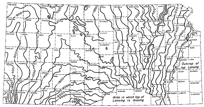
Lansing rocks extend over much of the state but have been eroded east of a line from Leavenworth County on the north to Montgomery County on the south. In a large area in the subsurface in parts of Barber, Harper, Sumner, Cowley, Sedgwick, and Chautauqua Counties, the top of the Lansing probably has been eroded; consequently it is not feasible to use that horizon as datum in the area (Winchell, 1957). Elsewhere, except in the extreme western part of the state, the top of the Lansing group (or top of the Stanton formation) is easily recognized in well logs. Thus, abundant information is available to facilitate use of this datum for structural contouring.
The most obvious structure on the map (Fig. 10) is the Nemaha, a southerly plunging anticline. The element is broader in the north in Marshall and Nemaha Counties. Just east of the Nemaha Anticline is the Brownville Syncline. The Bourbon Arch is not revealed on the map; hence the Forest City and Cherokee Basins are not shown as separate provinces, but, the western boundary of the combined basins is the east flank of the Nemaha Anticline. The Salina Basin axis lies close to the Central Kansas Uplift, showing the basin to be asymmetrical in cross section. A wide, gently dipping homocline modified by minor irregularities extends westward from the crest of the Nemaha to the trough of the Salina Basin. The Central Kansas Uplift is discernible as a northwesterly plunging "high" in Rice, Ellsworth, Barton, Russell, Ellis, and Rooks Counties. Several minor anticlinal features are associated with the uplift. The Cambridge Arch in Norton and Decatur Counties is represented as a southeasterly plunging anticline. The Hugoton Embayment lies west of the Central Kansas Uplift and Cambridge Arch. Axis of the embayment extends southward from Trego County through Ness, Edwards, and Kiowa Counties to Comanche County. The deepest part of the embayment is in Comanche County where Lansing rocks lie 2,800 feet below sea level, in contrast to 750 feet above sea level on the high point of the Nemaha Anticline. The western flank of the Hugoton is recognizable in extreme western Kansas. The steep northeast dip in Morton County reveals a flank of the Keyes Dome, which chiefly is in the Oklahoma Panhandle.
In addition to structures represented in Figure 10, it is deemed worthwhile to discuss briefly some other minor structures, in order to classify them geographically in various petroliferous provinces, which are defined in reference to the sub-Pennsylvanian buried surface. Some structures listed in this part probably are of comparatively recent origin, but most of them cannot be detected readily in surface rocks (Fig. 11).
Figure 11--Some minor structures in Kansas. 1. Abilene Anticline; 2. Alma-Davis Ranch Anticline; 3. Beaumont Anticline; 4. Bluff City-Valley Center-Elbing Anticline; 5. Brownville Syncline; 6. Burns Dome; 7. Chesney Dome; 8. Crooked Creek Fault; 9. Dexter-Otto Anticline; 10. Ellsworth Anticline; 11. Elmdale Dome; 12. Fairport Anticline; 13. Fowler Fault; 14. Halstead-Graber Anticline; 15. Jennings Anticline; 16. Long Island Syncline; 17. Longton Anticline; 18. McLouth Dome; 19. Mildred Dome; 20. Morris Anticline; 21. Mound City Dome; 22. Oil Hill Dome; 23. Rainbow-Graham Anticline; 24. Redbud Dome; 25. Rose Dome; 26. Rush Rib; 27. Silver City Dome; 28. Strahm Anticline; 29. Stuttgart-Huffstutter Anticline; 30. Syracuse Anticline; 31. Syracuse Fault; 32. Voshell Anticline; 33. Winfield Anticline.
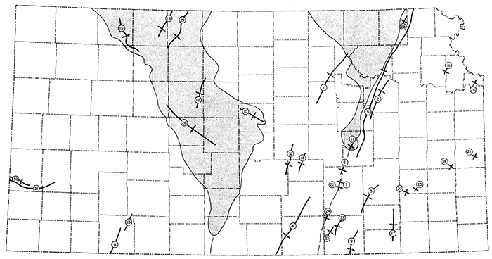
In the Cherokee Basin a belt about 60 miles wide just east of the Nemaha Anticline contains several anticlinal folds, the axes of which are approximately parallel to the larger anticline. In southeastern Elk County and in adjacent parts of Wilson and Chautauqua Counties, the Longton "ridge" has been identified in buried Pennsylvanian rocks along a line about 25 miles long. Another trend, extending from southeastern Cowley County northeastward to northeastern Greenwood County, contains the axes of the Otto, Dexter, and Beaumont Anticlines. In central Cowley County and farther west, the Winfield, Rainbow, and Graham Anticlines may be described as en echelon folds parallel to the Nemaha Anticline. These anticlines contain oil and gas pools. Farther east in the Cherokee Basin there are many other deviations from regional dip.
Only a few smaller structures in the Forest City Basin have been named. Sharp structures are obvious in outcropping rocks in Linn and Wyandotte Counties and other places. Small buried anticlines in the trough east of the Nemaha Anticline contain oil pools in Viola and "Hunton" rocks. There are similar oil-bearing structures in the trough of the Forest City Basin both to the north and south. The McLouth Dome, in Jefferson and Leavenworth Counties, is an example of a small dome, weakly revealed by outcropping rocks but becoming more pronounced and faulted at depth, in the Forest City basinal area. Oil and gas occur in the McLouth structure in Pennsylvanian and Mississippian rocks.
A fairly distinct anticlinal fold, called the Barneston Arch in its northern part and the Abilene Anticline farther south, extends from western Dickinson County or perhaps eastern Saline County northeastward to Marshall County and beyond into Nebraska (Jewett, 1951). Petroleum has not been found in the structure. Oil pools in Saline and McPherson Counties seemingly are in anticlinal structures that have axes in en echelon position with the Abilene Anticline. There are many other minor folds in the Salina Basin area.
The Sedgwick Basin has trends of anticlinal folds parallel to the Nemaha Anticline. One trend includes the Bluff City Anticline in Harper and Sumner Counties, Valley Center Anticline (with a great oil pool) in Sedgwick County, and Elbing and Florence-Urshel trends farther northeast. Large oil pools have been found along most of the length of nearly 100 miles. Farther west are the Halstead-Graber trend and the Voshell Anticline.
As elsewhere in Kansas, much oil on the Central Kansas Uplift area is produced from stratigraphic traps, but anticlinal folds, too, are of great importance. Some of the positive structural elements superposed on the larger structure are due to differential compaction of sediments above and around buried hills in the basement rocks. Several distinct folds of tectonic origin have axes trending northeast-southwest; the Fairport Anticline is an example (Fig. 11). It is nearly at right angles to the Rush Rib, which trends northwest through Ellis, Rush, and Barton Counties.
In the Hugoton Embayment many structural traps have small closure (Goebel and Merriam, 1957), hence are difficult to find, and therefore detailed work is necessary. Of more importance at present are stratigraphic traps, which account for a major share of production from this province.
In this discussion of smaller structures in the several petroliferous provinces, some mention of the occurrence of oil and gas in structural traps was made. It should be stated here that throughout the oil-producing parts of Kansas there are also a large number of oil pools in stratigraphic traps of various kinds. Space here does not permit discussion of the details of stratigraphic traps. Many, but not all, stratigraphic traps are below great unconformities, chief among which are the sub-Pennsylvanian unconformity along part of the Nemaha Anticline and on the Central Kansas Uplift; the sub-Chattanooga unconformity, especially on the ancient Chautauqua Arch; and the subMaquoketa unconformity, which has not been mentioned previously in this paper. In places beveled edges of Simpson, Viola, and other rocks are next below the Maquoketa.
Shoestring oil pools, properly classed as stratigraphic traps, are especially important in the Cherokee Basin and in the southern part of the Forest City Basin. The shoestrings, Pennsylvanian in age, are elongate sandstone bodies within shale. Examples of shoestring fields include Bush City, Colony West, Elsmore, FoxBush, Hamilton, Keighley, Quincy, Sallyards, Seeley-Wick, Teeter, and Thrall-Aagard. Shoestring sands in Butler and Greenwood Counties have been studied in detail by Bass (1936).
The great accumulation of gas in the Hugoton Gas Area in the Hugoton Embayment is trapped chiefly because of change in porosity of lower Permian strata on the eastern flank of the Las Animas Arch (Garlough and Taylor, 1941; Hemsell, 1939). The Novinger oil field occurs in a "reef-like" limestone body of Marmaton age (Renfroe, 1954). Other fields in the Hugoton Embayment are in lenticular sand bodies and may be classed as stratigraphic traps.
The sub-Mesozoic surface in western and central Kansas where Mesozoic sediments are present and an inferred pre-Mesozoic surface in eastern Kansas are shown on an areal geologic map (Fig. 12).
Figure 12--Distribution of rocks on surface below Mesozoic beds or inferred position in pre-Cretaceous time where cover is absent (taken in part from Merriam, 1957). Outcrop pattern of Permian formations in western Kansas is controlled by configuration of Hugoton Embayment of Anadarko Basin.
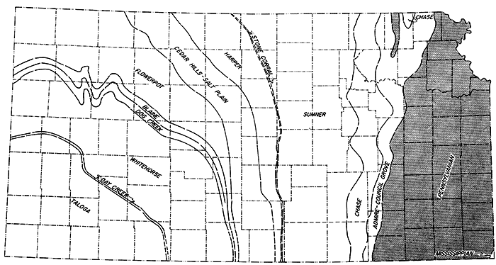
Figure 13 is a structural map contoured to show the present attitude of the .top of the Dakota formation, Gulfian Series (from Merriam, 1957b). Datum points used in making the map are limited to the western and central parts of Kansas because Cretaceous deposits are not present in eastern Kansas.
Figure 13---Structural map contoured on top of Dakota formation, Cretaceous (from Merriam, 1957b). Cambridge Arch is evident in Norton and Decatur Counties as is Salina Basin (?) in Smith and Phillips Counties, but other post-Mississippian structures are not revealed. Eastern flank of Las Animas Arch (axis located farther west in Colorado) is limited by marginal syncline, which extends from Finney County through Scott, Gove, and Thomas Counties to Cheyenne County.
Structural conditions revealed by mapping top of the Dakota formation indicate movements that occurred in Late Cretaceous and later time. Regional movements near the end of Cretaceous time and near the end of Tertiary time, which are most evident in the Rocky Mountains, affected most or all of Kansas.
In Paleozoic time the stratigraphic making of western Kansas chiefly was influenced by events that accompanied the development of the Anadarko Basin, but post-Cretaceous developments in western Kansas were closely connected with the subsidence of the Denver Basin. With the exception of the Cambridge Arch, formerly existing major elements in western Kansas were inactive. There may have been some activity along the Nemaha Anticline in eastern Kansas.
Three major structural features, including the Cambridge Arch that has been discuss_ed previously, are indicated on the Dakota structural map.
Figure 14--Mesozoic structural provinces in Kansas.
Development of the eastern flank of the Las Animas Arch in western Kansas can be recognized in beds as old as the Stone Corral formation (Permian), but the northeasterly dip on the flank was accentuated after Dakota time (Cretaceous) in Kansas. The arch was mainly a post-Cretaceous structural feature (Lee and Merriam, 1954).
The Cambridge Arch is evident in Cretaceous beds; this indicates differential structural movement there at least as late as post-Niobrara time. The arch separates the Western Kansas Basin on the west from the Salina Basin (?) on the east and plunges southward, dying out near the north end of the Central Kansas Uplift (Fig. 14). The arch was affected by adjustments in the Denver Basin and was subjected to northerly and northwesterly tilting.
The present land surface in Kansas is regarded as an important key to a large segment of the geologic history of the area. The land surface in Kansas slopes gently eastward through the eastern part of the High Plains, Plains Border, Smoky Hills, and scarped plains in the east. Altitude of the highest point in the state, in Wallace County, is 4,135 feet above sea level, and of the lowest point, in Montgomery County where Verdegris River flows into Oklahoma, is about 700 feet. Areal geology on the present land surface is shown in Figure 1. Eastward inclination of the land surface is discordant with regional structure of all outcropping rocks older than Tertiary. It is believed that the present eastward slope of the land was established near the end of Tertiary time.
In Kansas, east of the Flint Hills at about the geographic location of the Nemaha Anticline, outcropping Pennsylvanian and Permian rocks dip gently to the west and north of west. The average inclination of beds is about 20 to 25 feet per mile. The Nemaha Anticline interrupts and locally reverses the dip of outcropping strata (Fig. 3), and this regional dip is modified in many places. Direction of regional dip at various places is nearly that of radial lines extending from the center of the Ozark Dome as it is placed in Missouri by the areal geologic outcrop pattern on the present land surface. For some miles west of the Flint Hills the situation is comparable, except that direction of dip of Permian rocks that crop out there is more directly westward.
Dip of beds away from the Ozark area probably should be regarded as indication of regional uplift centered in the Ozark area. Because of the monotonous westerly dip of beds, the name Prairie Plains Monocline (Prosser and Beede, 1904) has been applied to the area (or to the structural element). The nearly parallel arrangement of Permian beds and other strata down to the sub-Pennsylvanian surface indicates that most of the inclination was developed after deposition of Permian sediments.
Three or more alluvial terraces in positions that range from a few feet above flood plains to about 200 feet above the valley floors are common in eastern Kansas. Their histories probably are directly connected with glaciation. Alluvial terraces are present in southeastern Kansas as well as along streams in and near glaciated northeastern Kansas. Alluvial fills below eastern Kansas flood plains are as much as 100 feet thick (Kansas River Valley at Kansas City).
Glacial till and outwash material are present almost everywhere in an area in northeastern Kansas bounded roughly by Missouri River, Kansas River, and Big Blue River. Bedrock outcrops are not plentiful in the glaciated area. Thickness of drift may exceed 200 feet, but in most places is less than 100 feet. Pre-Kansan valleys, now completely filled with as much as 200 feet of drift, are known. Well drillers have reported as much as 300 feet of unconsolidated material in places. Presence of comparatively thick glacial drift in northeastern Kansas is of consequence in investigations by geophysical methods.
Thick deposits of loess are present along Missouri and Kansas Rivers. Terraces along the river valleys in places are underlain by a section consisting of loess in the upper part and alluvium in the lower part. Reddish color is common to both materials, and close inspection is required to detect contacts. Where alluvium, loess, or glacial deposits are absent, soil in eastern Kansas is underlain by shale, siltstone, sandstone, or limestone. Limestone, and less commonly other rocks, may be seen in many natural exposures.
The eastern margin of Cretaceous deposits on the Kansas land surface has retreated farther west in southern Kansas than in the central and northern parts of the state. Hence along or near the southern boundary of Kansas, Permian rock~ crop out within 100 miles of the Colorado line (Fig. 1). These Permian beds are younger than those exposed farther east. The Blaine formation, mentioned previously as a subsurface marker, crops out in Comanche and Barber Counties. Hills in Barber County cut from Nippewalla redbeds are capped by Blaine gypsum. In the same area widespread karst topography has developed in the Blaine anhydrite and gypsum beds.
The Smoky Hills, eroded from Dakota sandstone and clay, mark the approximate eastern edge of Cretaceous deposits. Comanchean beds are present in areas just east of the Dakota sandstone hills; in Clark, Comanche, and Kiowa Counties there is a sizable area of Lower Cretaceous outcrop. These deposits, Kiowa shale and Cheyenne sandstone, are exceptionally well exposed in the vicinity of Belvidere in Kiowa County.
The Blue Hills, designated as the eastern margin of the High Plains, mark the eastern margin of thick Tertiary deposits in Kansas. The actual line of contact at the surface between Cretaceous (and very locally, in southern Kansas, Permian beds) and overlying thick and extensive Tertiary deposits is very irregular because of recent erosion. In Wallace County the line of contact is within a few miles of the Colorado border. These Tertiary beds are assigned to the Ogallala formation and are chiefly of Pliocene age, but it is possible that older Tertiary deposits, probably Miocene, are present in the subsurface in southwestern Kansas.
The Kansas part of the High Plains may be said to be built of Pliocene beds and veneered with Pleistocene. Most of the material was eroded from a former generation of Rocky Mountains. This thick accumulation of mostly unconsolidated material makes up a great wedge of silt, sand, clay, and gravel; it contains an abundance of fresh water.
An interesting layer of rock marks the top of the Ogallala formation. This is a pisolitic limestone that some authors call the "Algal limestone." According to Swineford, Leonard, and Frye (1958) it is thought to have developed by soil-forming processes acting on sands and silts of the uppermost part of the Ogallala formation. The absence of definite fossils; anomalous distribution of detrital grains with respect to oolites, pisolites, and bulbous structures; inverted orientation of bulbous structures themselves; and physiographic and climatic considerations all argue against algal origin of the rock. The so-called "Algal limestone" is a convenient datum plane; it is the uppermost part of the Ogallala formation, and except where there is local Pleistocene cover, it marks the High Plains surface and the top of the great mass of debris washed from the mountains.
The present attitude of the "Algal limestone" (Fig. 15) is essentially an eastward-dipping homocline modified by minor irregularities superposed on the major structure (Merriam and Frye, 1954). The surface is gently inclined eastward from an altitude of about 4,000 feet on the Kansas-Colorado line to about 1,600 feet in eastern Mitchell and Lincoln Counties in central Kansas. If more detailed control were available, the map probably would reveal minor noses and re-entrants in addition to those shown. The map does not reveal any pre-Tertiary structural provinces.
Figure 15--Structural map contoured on top of "Algal limestone," Neogene (from Merriam and Frye, 1954). Structure is gently eastward dipping homocline, minor structural noses and re-entrants being superposed on regional structure. Numerous outliers of "Algal limestone" east of main outcrop are not shown on map.
It is believed that deposition of the material that makes up the Ogallala formation is correlative with the cutting of a widespread peneplain or erosional surface in the Rocky Mountains (the Rocky Mountain or Flattop peneplain, Fenneman, 1931, p. 107). The present attitude of the top of the Ogallala formation, however, is not that of the surface at the time of its origin. At the time of completion of the peneplain in the mountains, a continuously graded plain made by degradation in the mountains and by aggradation in the plains area stretched far eastward. The High Plains at the time were not very high. Regional uplift took place soon after Ogallala deposition, and seemingly steepened the general eastward slope of the land surface of Kansas.
The over-all eastward inclination of the land surface in Kansas is not, of course, shown on a structure map unless the datum bed is parallel with the general land surface. A map of western Kansas showing present structure on top of the Ogallala formation, for example, does show inclination of the land surface. The present attitude of the surface does in large part, however, represent the result of tectonic movements, and movements that tilted the surface of Kansas tilted all rocks below the surface and tilted all preexisting structures. The eastward slope in Kansas has been modified to an undetermined but presumably negligible degree by erosion.
Atkinson, W. R. (1955) Preliminary study of the regional structure on top of the Lansing Group in western Kansas: Kansas Geol. Soc. Guidebook, 18th Field Conf., p. 77-79.
Barwick, J. S. (1928) The Salina Basin of north-central Kansas: Am. Assoc. Petroleum Geologists Bul1., v. 12, p. 177-199.
Bass, N. W. (1926) Geologic investigations in western Kansas, with special reference to oil and gas possibilities: Kansas Geol. Survey, Bull. 11, p. 1-96. [available online]
Bass, N. W. (1929) The geology of Cowley County, Kansas, with special reference to the occurrence of oil and gas: Kansas Geol. Survey, Bull. 12, p. 1-203. [available online]
Bass, N. W. (1936) Origin of the shoestring sands of Greenwood and Butler Counties, Kansas: Kansas Geol. Survey, Bull. 23, p. 1-135. [available online]
Berry, G. F., Jr., and Harper, P. A. (1948) Augusta field, Butler County, Kansas: Am. Assoc. Petroleum Geologists, Structure of Typical American Oil Fields, v. 3, p. 213-224.
Condra, G. E. (1927) The stratigraphy of the Pennsylvanian System in Nebraska: Nebraska Geol. Survey, Ser. 2, Bull. 1, p. 1-291.
Dreyer, R. M. (1947) Magnetic survey of the Bala intrusive, Riley County, Kansas: Kansas Geol. Survey, Bull. 70, pt. 2, p. 21-28. [available online]
Elias, M. K. (1931) The geology of Wallace County, Kansas: Kansas Geol. Survey, Bull. 18, p. 1-254. [available online]
Farquhar, O. C. (1957) The Precambrian rocks of Kansas: Kansas Geol. Survey, Bull. 127, pt. 3, p. 49-122. [available online]
Fath, A. E. (1921) Geology of the Eldorado oil and gas field: Kansas Geol. Survey, Bull. 7, p. 1-187. [available online]
Fenneman, N. M. (1931) Physiography of western United States: McGraw-Hill, New York, p. 1-534.
Frye, J. C., and Brazil, J. J. (1943) Ground water in the oil-field areas of Ellis and Russell Counties, Kansas: Kansas Geol. Survey, Bull. 50, p. 1-104. [available online]
Frye, J. C., and Leonard, A. B. (1952) Pleistocene geology of Kansas: Kansas Geol. Survey, Bull. 99, p. 1-230. [available online]
Frye, J. C., Leonard, A. B., and Swineford, Ada (1956) Stratigraphy of the Ogallala Formation (Neogene) of northern Kansas: Kansas Geol. Survey, Bull. 118, p. 1-89. [available online]
Garlough, J. L., and Taylor, G. L. (1941) Hugoton gas field, Grant, Haskell, Morton, Stevens, and Seward Counties,. Kansas, and Texas County, Oklahoma: Am. Assoc. Petroleum Geologists, Stratigraphic Type Oil Fields, p. 78-104.
Glover, R. H. (1953) Seismograph pays off in Kansas: World Oil; v. 137, no. 4, p. 109-110, 112, 114,116.
Goebel, E. D., and Merriam, D. F. (1957) "Trend players" look to western Kansas Cherokee: Oil and Gas Jour., v. 55, no. 13, p. 126-127, 130-132, 134-135.
Hemsell, C. C. (1939) Geology of Hugoton gas field of southwestern Kansas: Am. Assoc. Petroleum Geologists, Bull., v. 23, p. 1054-1067.
Howe, W. B. (1956) Stratigraphy of pre-Marmaton Desmoinesian (Cherokee) rocks in southeastern Kansas: Kansas Geol. Survey, Bull. 123, p. 1-132. [available online]
Jewett, J. M. (1941) The geology of Riley and Geary Counties, Kansas: Kansas Geol. Survey, Bull. 39, p. 1-164. [available online]
Jewett, J. M. (1951) Geologic structures in Kansas: Kansas Geol. Survey, Bull. 90, pt. 6, p. 105-172. [available online]
Jewett, J. M. (1951a) Eastern Kansas developments and prospects: World Oil, v. 133, no. 3, p. 100, 102, 104.
Jewett, J. M. (1954) Oil and gas in eastern Kansas: Kansas Geol. Survey, Bull. 104, p. 1-397.
Jewett, J. M., and Muilenburg, Grace (1957) Field conference in eastern Kansas: Kansas Geol. Soc. Guidebook, 21st Field Conf., p. 1-74.
Johnson, C. R. (1958) Geology and ground-water resources of Logan County, Kansas: Kansas Geol. Survey, Bull. 129, p. 1-174. [available online]
Knight, G. L., and Landes, K. K. (1932) Kansas laccoliths: Jour. Geol., v. 40, p.1-15.
Koester, E. A. (1935) Geology of Central Kansas Uplift: Am. Assoc. Petroleum Geologists, Bull., v. 19, p. 1405-1426.
Latta, B. F. (1946) Cretaceous stratigraphy of the Belvidere area, Kiowa County, Kansas: Kansas Geol. Survey, Bull. 64, pt. 6, p. 217-260. [available online]
Latta, B. F. (1948) Geology and ground-water resources of Kiowa County, Kansas: Kansas Geol. Survey, Bull. 65, p. 1-151. [available online]
Lee, Wallace (1939) Relation of thickness of Mississippian limestone in central and eastern Kansas to oil and gas deposits: Kansas Geol. Survey, Bull. 26, p. 1-42. [available online]
Lee, Wallace (1940) Preliminary report on the McLouth gas and oil field, Jefferson and Leavenworth Counties, Kansas: Kansas Geol. Survey, Bull. 38, pt. 10, p. 261-284. [available online]
Lee, Wallace (1943) The stratigraphy and structural development of the Forest City Basin in Kansas: Kansas Geol. Survey, Bull. 51, p. 1-142. [available online]
Lee, Wallace (1953) Subsurface geologic cross section from Meade County to Smith County, Kansas: Kansas Geol. Survey, Oil and Gas Inves. 9, p. 1-23. [available online]
Lee, Wallace (1956) Stratigraphy and structural development of the Salina Basin area: Kansas Geol. Survey, Bull. 121, p.1-167. [available online]
Lee, Wallace, Leatherock, Constance, and Botinelly, Theodore (1948) The stratigraphy and structural development of the Salina Basin of Kansas: Kansas Geol. Survey, Bull. 74, p. 1-155. [available online]
Lee, Wallace, and Merriam, D. F. (1954) Preliminary study of the structure of western Kansas: Kansas Geol. Survey, Oil and Gas Inves. 11, p. 1-23. [available online]
Lee, Wallace, and Merriam, D. F. (1954a) Cross sections in eastern Kansas: Kansas Geol. Survey, Oil and Gas Inves. 12, p. 1-8. [available online]
Maher, J. C., and Collins, J. B. (1948) Hugoton Embayment of Anadarko Basin in southwestern Kansas, southeastern Colorado, and Oklahoma Panhandle: Am. Assoc. Petroleum Geologists, Bull., v. 32, p. 813-819.
McLaughlin, T. G. (1942) Geology and ground-water resources of Morton County, Kansas: Kansas Geol. Survey, Bull. 40, p. 1-126. [available online]
McLaughlin, T. G. (1943) Geology and ground-water resources of Hamilton and Kearny Counties, Kansas: Kansas Geol. Survey, Bull. 49, p. 1-220. [available online]
McClellan, H. W. (1930) Subsurface distribution of pre-Mississippian rocks of Kansas and Oklahoma: Am. Assoc. Petroleum Geologists, Bull., v. 14, p. 1535-1556.
Merriam, D. F. (1955) Jurassic rocks in Kansas: Am. Assoc. Petroleum Geologists, Bull., v. 39, p, 31-46.
Merriam, D. F. (1955a) Structural development of the Hugoton Embayment: Proc. 4th Subsurface Symposium, Oklahoma Univ., Norman, p. 81-97.
Merriam, D. F. (1957) Subsurface correlation and stratigraphic relation of rocks of Mesozoic age in Kansas: Kansas Geol. Survey, Oil and Gas Inves. 14, p. 1-25. [available online]
Merriam, D. F. (1957a) Notes on the Permian Stone Corral formation of central and western Kansas: Compass, v. 34, p. 267-277.
Merriam, D. F. (1957b) Preliminary regional structural contour map on top of the Dakota formation (Cretaceous) in Kansas: Kansas Geol. Survey, Oil and Gas Inves. 15, map. [PDF available online]
Merriam, D. F., and Atkinson, W. R. (1955) Tectonic history of the Cambridge Arch in Kansas: Kansas Geol. Survey, Oil and Gas Inves. 13, p. 1-28. [available online]
Merriam, D. F., and Frye, J. C. (1954) Additional studies of the Cenozoic of western Kansas: Kansas Geol. Survey, Bull. 109, pt. 4, p. 49-64. [available online]
Moore, R. C. (1936) Stratigraphic classification of the Pennsylvanian rocks of Kansas: Kansas Geol. Survey, Bull. 22, p. 1-256. [available online]
Moore, R. C. (1949) Divisions of the Pennsylvanian System in Kansas: Kansas Geol. Survey, Bull. 83, p. 1-204. [available online]
Moore, R. C., and Haynes, W. P. (1920) An outcrop of basic igneous rock in Kansas: Am. Assoc. Petroleum Geologists, Bull., v. 4, p. 183-187.
Moore, R. C., and Jewett, J. M. (1942) Oil and gas fields of Kansas: Mines Magazine, v. 32, no. 10, p. 481-488, 515-520, 524, 526, 538, and 560.
Moore, R. C., and Landes, K. K. (1937) Geological map of Kansas: Kansas Geol. Survey, map.
Moore, R. C., Frye, J. C., and Jewett, J. M. (1944) Tabular description of outcropping rocks in Kansas: Kansas Geol. Survey, Bull. 52, pt. 4, p. 137-212. [available online]
Moore, R. C., and others (1951) The Kansas rock column: Kansas Geol. Survey, Bull. 89, p. 1-132. [available online]
Moore, R. C., and others (1951a) Geology, mineral resources, and ground-water resources of Chase County, Kansas: Kansas Geol. Survey v. 11, p. 1-49. [available online]
Moore, R. C., and others (1952) Graphic column of Kansas rocks: Kansas Geol. Survey, chart.
Morgan, L. C. (1932) Central Kansas Uplift: Am. Assoc. Petroleum Geologists, Bull., v. 16, p. 483-484.
O'Connor, H. G., Goebel, E. D., and Plummer, Norman (1953) Geology, mineral resources, and ground-water resources of Lyon County, Kansas: Kansas Geol. Survey v. 12, p. 1-59. [available online]
O'Connor, H. G., Goebel, E. D., Schoewe, W. H., and Plummer, Norman (1955) Geology, mineral resources, and ground-water resources of Osage County, Kansas: Kansas Geol. Survey v. 13, p. 1-50. [available online]
Plummer, Norman, and Romary, J. F. (1942) Stratigraphy of the pre-Greenhorn Cretaceous beds of Kansas: Kansas Geol. Survey, Bull. 41, pt. 9, p. 313-348. [available online]
Prosser, C. S., and Beede, J. W. (1904) Description of the Cottonwood Falls quadrangle: U.S. Geol. Survey Geologic Atlas, Folio 109, p. 1-6. [available online]
Renfroe, C. A. (1954) New Kansas pool may mean more reef-like fields: World Oil, v. 139, no. 5, p. 113-116, 120.
Rich, J. L. (1933) Distribution of oil pools in Kansas in relation to pre-Mississippian structure and areal geology: Am. Assoc. Petroleum Geologists, Bull., v. 17, p. 793-815.
Rubey, W. W., and Bass, N. W. (1925) The geology of Russell County, Kansas, with special reference to oil and gas resources: Kansas Geol. Survey, Bull. 10, pt. 1, p. 1-86. [available online]
Smith, R. K., and Anders, E. L., Jr. (1951) The geology of the Davis Ranch oil pool, Wabaunsee County, Kansas: Kansas Geol. Survey, Bull. 90, pt. 2, p. 13-52. [available online]
Swineford, Ada (1955) Petrography.of upper Permian rocks in south-central Kansas: Kansas Geol. Survey, Bull. 111, p. 1-179. [available online]
Swineford, Ada, Leonard, A. B., and Frye, J. C. (1958) Petrology of the Pliocene pisolitic limestone in the Great Plains: Kansas Geol. Survey, Bull. 130, pt. 2, p. 97-116. [available online]
Thompson, M. L. (1944) Pennsylvanian Morrowan rocks and fusulinids of Kansas: Kansas Geol. Survey, Bull. 52, pt. 7, p. 409-431. [available online]
Twenhofel, W. H. (1924) The geology and invertebrate paleontology of the Comanchean and "Dakota" formations of Kansas: Kansas Geol. Survey, Bull. 9, p. 1-135. [available online]
Twenhofel, W. H., and Edwards, E. C. (1921) The metamorphic rocks of Woodson County, Kansas: Am. Assoc. Petroleum Geologists, Bull., v. 5, p. 64-74.
Wagner, H. C. (1954) Geology of the Fredonia Quadrangle, Kansas: U. S. Geol. Survey Geologic Quadrangle Map, G.Q. 49. [available online]
Walters, R. F. (1946) Buried Precambrian hills in northeastern Barton County, central Kansas: Am. Assoc. Petroleum Geologists, Bull., v. 30, p.660-710.
Winchell, R. L. (1957) Relationship of the Lansing Group and the Tonganoxie ("Stalnaker") sandstone in south-central Kansas: Kansas Geol. Survey, Bull. 127, pt. 4, p. 123-152. [available online]
Kansas Geological Survey
Comments to webadmin@kgs.ku.edu
Web version Oct. 21, 2013. Original publication date 1959.
URL=http://www.kgs.ku.edu/Publications/Bulletins/137/Jewett/index.html