Kansas Geological Survey, Bulletin 70, Part 2, originally published in 1947
Originally published in 1947 as of Kansas Geological Survey Bulletin 70, pt. 2. This is, in general, the original text as published. The information has not been updated. This publication is also available as an Acrobat PDF file (4 MB).
A magnetic survey of the Bala intrusive with a vertical magnetometer indicates that the intrusive is an eastwardly-plunging vertical dike.
The Bala intrusive is one of the few igneous intrusives exposed in Kansas. It is located a few hundred feet southeast of the NW cor. T. 9 S., R. 5 E. in western Riley County.
The intrusive forms a low knob about 20 feet in height and 200 feet in diameter. A shoulder runs eastward from the crest of the knob. The slope on the west side of the knob is relatively steep.
This survey was undertaken to supplement drill-hole data and to see whether relatively large amounts of this rock could be obtained at or near the surface. The survey was made in October 1946 using a Schmidt-type vertical magnetometer. Topographic control was established by A. R. Glockzin, assisted by J. E. Keller.
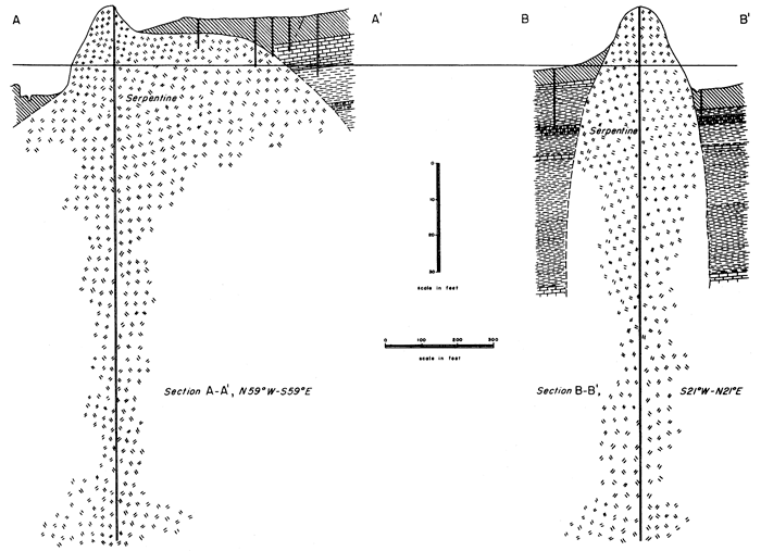
The structure contour map and cross sections are based on drilling carried out under the direction of and mapped by H. H. Munger, Kansas State College. The author is very much indebted to Mr. Munger for permission to use his structural data.
The intrusive was first described by Moore and Haynes (1920) and, subsequently, by Jewett (1941, pp. 96-97).
The intrusive cuts Permian shales and limestones of the Winfield formation (Jewett, 1941, p. 97). The contact with the surrounding rocks is not exposed, although Jewett (p. 97) reports that there is some folding 0.1 mile west of the intrusive and a small fault about 0.25 miles west of the intrusive. Small-scale folding and faulting are stated by Jewett to be rather common in this area and, therefore, the folding and faulting near the intrusive may not have resulted from the intrusion.
Moore and Haynes (1920) have given a detailed description of the petrography of the intrusive. The rock is a green, serpentinized and carbonatized, porphyritic, peridotite breccia containing numerous shale xenoliths. The ground mass consists essentially of serpentine and calcite with considerable chromite. There is also some magnetite. The phenocrysts consist largely of altered olivine with some altered augite and biotite.
It would be expected that an intrusive containing not only magnetite and chromite, but also ferromagnesian silicates, would show a marked anomaly in juxtaposition to shale and limestone. Such anomalies should result in a marked increase in the vertical magnetic field over the intrusive. An interpretation of the anomaly might thus indicate the form of the intrusive.
The topographic datum is based on an assumed elevation of 1,400 feet at the crest of the knob. The elevation is in general accord with the topographic sheet for the Junction City quadrangle. The magnetic datum is the vertical magnetic intensity at the township corner. The isogams (lines of equal magnetic intensity, in gammas), are plotted at 500-gamma intervals up to 3,500 gammas except that the depression isogams are at intervals of 2,000 gammas. The structural datum is shown on the cross sections (Fig. 4). The magnetic anomaly reaches a magnitude of more than 3,500 ganunas.
It will be noted (Figs. 1, 2, and 3) that the location, trend, and form of the magnetic high are, with the exception to be noted below, in excellent accord with both the topography and structure. Thus the magnetic high is centered around the borders of the topographic and structural summit of the knob and trends eastwardly in general parallelism with the topographic and structural shoulder confirming the eastward plunge of the intrusive. The magnetic high is slightly asymmetrical toward the south, but this asymmetry probably is caused by the northward inclination of the earth's magnetic field. Of particular interest is the marked magnetic low which occurs at the center of the high zone and coincides with the center of the outcrop of the intrusive. The magnetic field around the intrusive is thus a hollow, elliptical high (trending eastwardly in the direction of the plunge) completely surrounding an elliptical low. This type of anomaly is very similar to that found by Blum (1945, pp. 371-375) over igneous pipes near Canon City, Colorado.
Figure 1--Magnetic and topographic map of Bala intrusive, Riley County, Kansas.
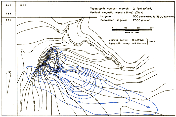
Figure 2--Structural and magnetic map of Bala intrusive, Riley County, Kansas.
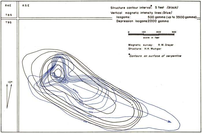
Figure 3--Structural and topographic map of Bala intrusive, Riley County, Kansas.
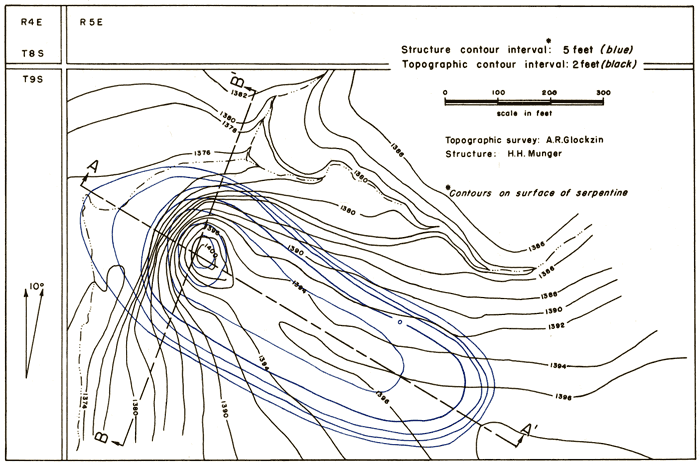
Figure 4--Cross sections through Bala intrusive, Riley County, Kansas.
Relatively large amounts of this intrusive could be obtained at or near the surface by following the intrusive eastward from the crest along the magnetic high.
The isoanomalic map confirms the structure of the intrusive as indicated by drill data. The intrusive is a vertical, eastwardly plunging dike. The topography, structure, and vertical magnetic field of the intrusive are in good accord.
Blum, V. J., 1945, The magnetic field over igneous pipes: Geophysics, vol. 10, pp. 368-375.
Jewett, J. M., 1941, The geology of Riley and Geary Counties, Kansas: Kansas Geol. Survey, Bull. 39, pp. 1-164, figs. 1-2, pls. 1-17. [available online]
Moore, R. C., and Haynes, W. P., 1920, An outcrop of basic igneous rock in Kansas: Am. Assoc. Petroleum Geologists, Bull., vol. 4, pp. 183-187.
Kansas Geological Survey, Geology
Placed on web April 20, 2009; originally published in 1947.
Comments to webadmin@kgs.ku.edu
The URL for this page is http://www.kgs.ku.edu/Publications/Bulletins/70_2/index.html