![]()
Prev Page--Ground-Water Occurrence || Next Page--Utilization, Quality
Ground Water, Continued
Ground-water Recharge
Recharge is the addition of water to the ground-water reservoir and may be derived by precipitation in the area, by seepage of water from streams, by seepage of irrigation water, and by underflow.
Recharge from Underflow
As shown by the water-table contour map (pl. 1), ground water in the Hamilton-Kearny area moves east-southeastward. As a result, water percolates into some of the Tertiary and Quaternary deposits of this area from Prowers County, Colorado, and from Greeley and Wichita counties, Kansas. Most of the water in these formations moves from Prowers County, Colorado, into Hamilton County and thence eastward and northward.
Within the Hamilton-Kearny area, some of the water-bearing formations are recharged by leakage of water from the Dakota formation. Water rises from the Dakota formation into the overlying alluvium in the vicinity of Hartland. Along the southern margin of the Syracuse upland, faulting has brought the Dakota formation into contact with the sands and gravels of Pleistocene age and water can move from the Dakota formation into Pleistocene beds. Generally, water is encountered at the top of the Dakota formation, but near the fault most wells encounter water between 20 and 30 feet below the top of the Dakota. This indicates that much of the water has been drained out of the formation into the Pleistocene beds.
In the vicinity of Kendall, however, a different condition may exist. Well 70 (fig. 12), which obtains its water from the Dakota formation, appears to fluctuate in response to the precipitation, thus suggesting that water from the alluvium may move into the Dakota formation in this locality. Otherwise, the water level in this well probably would not fluctuate so closely with the precipitation.
Recharge from Streams and Irrigation Water
At one time Arkansas river probably was a gaining stream throughout all of Hamilton and Kearny counties. This is indicated by the fact that many of the early irrigation plants in this area pumped water directly from the river. In recent years, however, Arkansas river often is dry in eastern Kearny County and during the summer it occasionally becomes dry in Hamilton County. Arkansas river often is dry between Hartland and Garden City, particularly during the summer. This has probably been caused by the heavy pumping of water for irrigation, which has lowered the water table and has caused the river to become a losing stream. In Hamilton County, where the water table usually is above the stream bed, ground water discharges into the stream channel. When this flow of water reaches a dry section of the stream it returns to the ground-water reservoir.
Table 6 shows the magnitude of the loss in stream flow between Syracuse and Garden City. Between October 1, 1922, and September 30, 1942, the average yearly net loss of water between Syracuse and Garden City was about 31,600 acre-feet. Most of this water was lost between Hartland and Garden City where the Arkansas usually is a losing stream. If the loss were uniformly distributed between Hartland and Garden City, about 19,000 acre-feet was lost in eastern Kearny County. Some of the loss was caused by evaporation and transpiration, but much of the water probably reached the zone of saturation.
Table 6--Annual discharge of Arkansas river at Syracuse and Garden City, diversion of water by canals, and loss or gain of stream flow between Syracuse and Garden City, for the 20-year period from Oct. 1, 1922, to Sept. 30, 1942. From records of the Division of Water Resources, Kansas State Board of Agriculture. Canals include Amazon, South Side, Great Eastern, Farmer's, and Garden City canals.
| Water year (October 1 through September 30) |
Annual discharge at Syracuse (acre-feet) |
Annual discharge at Garden City (acre-feet) |
Loss (-) or gain (+) between Syracuse and Garden City |
|||
|---|---|---|---|---|---|---|
| Total (acre-feet) |
Diversion into canals (acre-feet) |
Net loss or gain exclusive of diversion |
||||
| Acre-feet | Percentage of discharge at Syracuse |
|||||
| 1922-1923 | 594,000 | 484,000 | -110,000 | -88,761 | -21,329 | 3.6 |
| 1923-1924 | 533,000 | 562,581 | +29,581 | -48,537 | +78,118 | 14.7 |
| 1924-1925 | 252,000 | 113,000 | -139,000 | -65,327 | -73,673 | 29.2 |
| 1925-1926 | 106,000 | 15,600 | -90,400 | -58,867 | -31,533 | 29.7 |
| 1926-1927 | 356,000 | 204,000 | -152,000 | -88,040 | -63,960 | 18.0 |
| 1927-1928 | 310,000 | 236,000 | -74,000 | -50,280 | -23,720 | 7.7 |
| 1928-1929 | 232,000 | 133,000 | -99,000 | -105,830 | +6,830 | 2.9 |
| 1929-1930 | 152,000 | 42,600 | -109,400 | -84,670 | -24,730 | 16.3 |
| 1930-1931 | 219,000 | 120,000 | -99,000 | -60,650 | -38,350 | 17.5 |
| 1931-1932 | 64,100 | 11,700 | -52,400 | -42,190 | -10,210 | 15.9 |
| 1932-1933 | 161,000 | 50,000 | -111,000 | -86,360 | -24,640 | 15.3 |
| 1933-1934 | 68,900 | 11,960 | -56,940 | -42,140 | -14,800 | 21.5 |
| 1934-1935 | 221,600 | 81,720 | -139,880 | -79,840 | -60,040 | 27.1 |
| 1935-1936 | 323,800 | 199,400 | -124,400 | -93,370 | -31,030 | 9.6 |
| 1936-1937 | 117,500 | 37,290 | -80,210 | -67,180 | -13,030 | 11.1 |
| 1937-1938 | 199,200 | 32,940 | -166,260 | -124,060 | -42,200 | 21.1 |
| 1938-1939 | 80,800 | 21,550 | -59,250 | -58,590 | -660 | 0.8 |
| 1939-1940 | 24,880 | 1,340 | -23,540 | -14,622 | -8,918 | 36.3 |
| 1940-1941 | 234,500 | 93,925 | -140,575 | -109,990 | -30,585 | 13.0 |
| 1941-1942 | 1,411,610 | 1,223,380 | -188,240 | -110 321 | -77,909 | 5.5 |
Another contributor of water to the zone of saturation in the Hamilton-Kearny area is the lower part of Bear creek. The channel of Bear creek has been choked by the encroachment of dune sand and water cannot flow northward into Arkansas river.
The addition of water from Bear creek to the ground-water reservoir in south central Kearny County has caused the formation of a prominent mound on the water table (pl. 1). The altitude of the water level in well 354 is about 15 feet greater than the altitude of the water level in well 352, which is 2.7 miles north of well 354, and it is about 24 feet greater than the altitude of the water level in well 353, which is 2 miles northeast of well 354. Farther north, beyond the reach of most of the flood waters of Bear creek, the recharge has had less apparent effect upon the shape of the water table. The recharge here has produced a broad flattening of an otherwise uniform dip (pl. 1).
When water is diverted from Arkansas river into irrigation canals, a part of the water is lost by downward percolation. This is not a complete loss, however, because much of the water reaches the zone of saturation and increases the quantity of water available to wells. Similarly, water from irrigation wells may be lost when it is being transported in ditches and after it has been spread over the fields, but part of this water returns to the ground-water reservoir.
Plate 8--A, Amazon irrigation canal near Hartland; B, Headgate of Amazon irrigation canal.
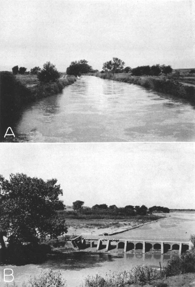
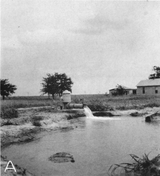
Plate 9--A, Electrically-driven turbine pump in the Arkansas valley 1 mile east of Deerfield; B, Irrigation plants and canal of the Garden City Company in the Arkansas valley.
Recharge from Precipitation
Although the average annual precipitation in this area is about 17 inches, only a small part reaches the zone of saturation. Of the total precipitation, part is lost by evaporation and transpiration, part leaves the area as runoff, and the remainder may percolate downward to the zone of saturation.
The quantity lost by evaporation depends upon precipitation, temperature, humidity, amount of vegetative covering, depth to the water table below the land surface, and length of time the processes of evaporation have access to the moisture.
In Hamilton and Kearny counties much of the precipitation occurs from May through August when the climate is characterized by high temperatures and low humidity and plant growth is relatively abundant. Much of the precipitation in this area, therefore, is lost by evaporation. In a large part of the Kearny and Syracuse upland areas where sink holes and other depressions are fairly abundant, rain and snow water may stand for many days, during which much evaporation takes place.
Some of the precipitation is also lost by runoff, but the amount generally is small except after very heavy rains. According to records of the Division of Water Resources of the Kansas State Board of Agriculture, the average annual net runoff in Arkansas river drainage area above Garden City for the period October 1, 1928, to September 30, 1939, was only 0.09 inch (excluding water diverted by irrigation canals west of Garden City). The maximum annual runoff during that period occurred between October 1, 1928, and September 30, 1929, and was 0.56 inch. The average annual runoff is less than one percent of the average annual precipitation. In the sand-hills area and on the upland, the runoff is reduced materially because of many undrained basins which catch and retain water after each rain. The water stands in the basins until it evaporates or moves downward toward the water table. Vegetation also retards the runoff, particularly during the growing season. During other seasons, however, the vegetation has little effect upon the runoff. Modern methods of terracing and contouring of farm land tend to reduce the runoff and, therefore, may increase the rate of recharge to the soil and to the ground-water reservoir.
The water that is not lost by evaporation and runoff percolates downward into the soil zone. The soil will absorb moisture until the amount of water it contains is greater than can be held against the pull of gravity, and not until that time will water move downward to the zone of saturation. This downward movement may be prevented by plant transpiration which, during the growing season, may deplete the soil moisture as rapidly as it can be replenished by precipitation. At the end of the growing season the moisture in the soil may be depleted. Water that enters the soil zone during the fall and winter tends to replenish the soil moisture because there is less transpiration and evaporation during these seasons. From this time until transpiration and evaporation again become important factors, much of the precipitation moves downward through the soil and to the water table. Because of the high rate of transpiration and evaporation, there is probably little recharge during the summer except where the water table is relatively close to the land surface.
Sand-hills area--Recharge of the ground-water reservoir in the sand-hills area south of Arkansas river is derived largely from precipitation. Because of the high porosity of the dune sand and the presence of many undrained basins that serve as catchment areas for the rainfall, much water percolates downward to the zone of saturation. Most of the precipitation in this area is held in the basins until it percolates downward and/or evaporates. Very little water is lost by runoff. The Arkansas valley probably derives part of its ground water by lateral movement from adjacent areas. Much of this probably is derived from the sand-hills area to the south. The huge area of sand hills that extend from Prowers County, Colorado, to Ford County, Kansas, serves as the principal recharge area for the ground-water reservoir in much of southwestern Kansas.
Upland areas--The recharge of the ground-water reservoir in the upland areas probably is relatively small as compared to the recharge in the Arkansas valley and in the sand-hills area. Much of the upland in Hamilton and Kearny counties is covered by fairly thick deposits of wind-blown loess. Soils that develop from loess are heavy and dark and consist of topsoils of loams, clay loams, and silty clay loams and heavy clay subsoils that in places are very calcareous. The loess soils have a moderately high porosity and hold moisture well, but because of their low permeability they absorb moisture very slowly.
One of the most important factors affecting the recharge of the upland areas by precipitation is the sink-hole topography. These broad, shallow depressions are abundant in the Hamilton-Kearny area, particularly in the Kearny upland and along the fault at the southern margin of the Syracuse upland (pl. 16A). After heavy rains the depressions are filled with water which may remain for several weeks until it evaporates and/or percolates downward. Although the soil has a fairly low permeability, the water has access to the soil for such a long period of time that a considerable amount of water probably reaches the zone of saturation.
As shown on plate 1, an intermittent stream extends southeastward from northeastern Hamilton County across northern Kearny County and terminates in a broad shallow depression. In the vicinity of the depression there is an abrupt flattening of an otherwise relatively steep slope of the water table. This may be due in part to the slope of the underlying Cretaceous bedrock floor, but it probably is caused mainly by recharge of water from the depression. More convincing evidence of this type of recharge was described by Latta (1943). In eastern Gray County, about 2 miles north of Arkansas river, a small mound has been formed on the water table by recharge from water in a broad depression. The depth to the water table at this point is more than 100 feet. In north central Box Butte County, Nebraska, Cady (1940, p. 573) found that the recharge ranged in amount from 0.75 inch to slightly more than an inch in an area where the water table is 100 to 250 feet below the surface.
Further evidence of recharge of the ground-water reservoir in upland areas is indicated by the fluctuations of the water table. The fact that the water level in some deep wells fluctuates only slightly does not necessarily mean that there is no recharge, for the water level will rise only when the rate of recharge exceeds the rate of ground-water discharge. It is more probable that the recharge in such areas is more or less continuous and is about equal to the natural discharge. Although the annual net rise in water levels in the deep wells in the upland area of Hamilton and Kearny counties is fairly small, the cumulative rise is relatively large. In table 7 are listed the cumulative rises of water levels in wells on upland areas in Hamilton and Kearny counties determined by adding the rises of water levels based on monthly water-level measurements. The average annual cumulative rise in water level in these wells is about 1 foot, but the amount of cumulative rise varies from year to year, depending primarily upon the precipitation.
Table 7--Cumulative rise in water level in upland wells in Hamilton and Kearny counties. 1. Record incomplete for the year.
| Well No. | Cumulative rise in water level, in feet | ||
|---|---|---|---|
| October, 1939, to October, 1940 |
October, 1940, to October, 1941 |
October, 1941, to October, 1942 |
|
| 9 | 0.69 | 0.191 | 0.331 |
| 13 | .34 | .821 | |
| 20 | .80 | ||
| 24 | .93 | 1.17 | .47 |
| 25 | .341 | ||
| 37 | .38 | .24 | .89 |
| 167 | 1.04 | .03 | |
| 177 | .20 | ||
| 189 | 1.06 | .651 | |
| 196 | .18 | 2.561 | .13 |
| 202 | .27 | .771 | |
| 205 | .87 | .72 | |
| 209 | .03 | .551 | 3.05 |
| 219 | 3.10 | .73 | 2.86 |
| 232 | .03 | ||
| 286 | 2.45 | 2.86 | 5.22 |
| 308 | .91 | .94 | .88 |
| 313 | .38 | ||
| 351 | .43 | 1.041 | .97 |
| 353 | .01 | .691 | .66 |
| 357 | .54 | 1.51 | 1.45 |
Most of the water in the ground-water reservoir in the eastern half of the Kearny upland probably is derived from precipitation on the Kearny upland. Because the relatively impermeable Cretaceous beds lie above the water table in the western half of the Kearny upland area (fig. 7), it would seem that very little water moves eastward into northern Kearny County. Some water may move through this Cretaceous bedrock barrier, but the amount probably is negligible.
A few wells in northern Hamilton County encounter water just above the Cretaceous bedrock, whereas other wells in that area generally fail to find water at that horizon. This may imply that some water moves eastward down the slope of the bedrock surface along pre-Tertiary and Quaternary drainage channels. This water probably is derived from precipitation on the western half of the Kearny upland.
Arkansas valley area--Recharge from precipitation in the Arkansas valley is relatively large because the water table is near the surface and because the soil is fairly pervious. During successive years of below-normal precipitation, the water table in the Arkansas valley in Hamilton and Kearny counties usually declines. This is caused not only by the decreased precipitation but also by increased pumping for irrigation. The water table returns to or nearly to its previous high level, however, after a few years of above-normal precipitation. The relations of the water-level fluctuations to the precipitation are shown in figures 11, 12, 13 and 14.
Although some valley wells show a net decline in water level during some years, the cumulative rise in water level generally is large. The cumulative rises in water level in a few wells in the Arkansas valley are listed in table 8. The average annual cumulative rise in water levels in these wells is more than 2 feet, but the average rise varies considerably with the precipitation.
Table 8--Cumulative rise in water level in wells in the Arkansas valley and adjacent shallow-water areas in Hamilton and Kearny counties. 1. Record incomplete for the year. 2. Water level affected by flood in Arkansas river in April and May, 1942.
| Well No. | Cumulative rise in water level, in feet | ||
|---|---|---|---|
| October, 1939, to October, 1940 |
October, 1940, to October, 1941 |
October, 1941, to October, 1942 |
|
| 44 | 1.271 | 1.681 | 0.881 |
| 52 | .511 | 1.461 | 1.761 |
| 68 | 3.17 | ||
| 7o | 1.90 | 1.95 | 2.18 |
| 80 | 1.71 | 2.76 | 1.57 |
| 82 | 5.59 | 3.80 | |
| 105 | .96 | ||
| 109 | .25 | 1.58 | 2.68 |
| 240 | 1.621 | ||
| 252 | 1.281 | 4.831 | 3.6o |
| 300 | .70 | 4.12 | 4.40 |
| 335 | .20 | 1.621 | 1.48 |
| 340 | .99 | 3.09 | 2.35 |
| 343 | 3.19 | 4.37 | 6.352 |
Another indication that there must be considerable recharge of the ground-water reservoir in the Arkansas valley as a result of precipitation is the small underflow in the narrow part of the valley about 2 miles west of Hartland. Here the river has cut its valley into relatively impermeable Cretaceous rocks, including the Graneros shale and a dense quartzitic sandstone in the Dakota formation. The alluvium at this point is only 2,250 feet wide and has an average thickness of about 33 feet. Slichter (1906, p. 24) calculated the underflow at this point by the ground-water velocity method and found it to be about 2,100 acre-feet a year. He stated that the above figure "represents the maximum that can be claimed in a high estimate." The results of pumping tests made on three wells in the Arkansas valley in Hamilton and Kearny counties (table 4, wells 91, 92, and 268) indicate that the underflow is considerably less than 2,100 acre-feet a year, and probably is only about 1,000 acre-feet a year. An underflow of 1,000 acre-feet of water a year would be equivalent to less than 700 gallons a minute and would be inadequate to supply either the nearly 20,000 acre-feet of water that is withdrawn annually for irrigation in the Arkansas valley in eastern Kearny County or the large quantity of water that is transpired by plants. If it is assumed that most of the loss in the flow of Arkansas river between Syracuse and Garden City takes place east of Hartland, then Arkansas river would contribute about 19,000 acre-feet of water a year to the ground-water reservoir in eastern Kearny County. If this assumption is incorrect, then the river probably would contribute less than 19,000 acre-feet of water a year to the groundwater reservoir. The remainder of the water pumped for irrigation (about 1,000 acre-feet a year) and transpired by plants probably is derived chiefly from precipitation.
Precipitation upon the upland areas near the Arkansas valley may also contribute water to the ground-water reservoir in the Arkansas valley. After excessively heavy rains on the upland some water may run off into the valley and then percolate downward to the zone of saturation. This is particularly true in Hamilton County where there are many intermittent streams on the Kearny upland that flow southward to the Arkansas valley.
Recharge of the Artesian Aquifers
As discussed in the section on recharge from underflow, the water in the Cheyenne and Dakota formations moves into Hamilton County from the west. The water enters the formations from precipitation on the areas where they crop out and moves eastward and northeastward into Kansas. These formations are exposed in a large part of southeastern Colorado, particularly in Prowers, Bent, Otero, Baca, and Las Animas counties.
Discharge of Subsurface Water
The discharge of subsurface water has been divided by Meinzer (1923a, pp. 48-56) into vadose-water discharge (discharge of soil water not derived from the zone of saturation) and ground-water discharge (discharge of water from the zone of saturation).
Vadose-water Discharge
The discharge of soil water not derived from the zone of saturation is called vadose-water discharge and includes the discharge of water directly from the soil by evaporation and through growing plants and crops by transpiration. The consumption of soil water by crops is large and is of vital importance to agriculture. This consumption of soil water generally reduces the recharge, for the deficiency of soil moisture must first be replenished before recharge can take place.
Ground-water Discharge
Ground-water discharge is the discharge of water directly from the zone of saturation or from the capillary fringe, and may take place through evaporation and transpiration or as hydraulic discharge through springs, seeps, wells, or infiltration galleries.
Discharge by transpiration and evaporation--Water may be taken into the roots of plants directly from the zone of saturation or from the capillary fringe, and discharged from the plants by the process known as transpiration. The depth from which plants will lift the ground water varies with different plant species and different types of soil. The limit of lift by ordinary grasses and field crops is not more than a few feet; however, alfalfa and certain types of desert plants have been known to send their roots to depths of 60 feet or more to reach the water table (Meinzer, 1923, p. 82).
In Hamilton and Kearny counties, any significant discharge of water by evaporation and transpiration is limited to the shallow-water areas in the Arkansas valley, the Scott-Finney basin, and the Bear Creek depression. Although the water level is less than 50 feet below land surface in part of the sand-hills area, very little ground water is lost by transpiration because the sandy soil supports a type of vegetation that cannot send its roots downward more than a few feet. A very large quantity of water is lost by transpiration in the Arkansas valley shallow-water area because trees, alfalfa, and many other plants extend their roots to the water table and take water directly from the zone of saturation. In some parts of the valley, particularly in old abandoned channels of Arkansas river, the water table is sufficiently close to the land surface to support a marshy vegetation. Evaporation of water directly from the zone of saturation is confined primarily to the channel of Arkansas river and the adjacent, lowlands or "first bottom," to some abandoned channels of the river, and to Clear lake.
The water table is somewhat deeper in the Scott-Finney shallow-water area where alfalfa and trees probably are the only plants that extend their roots to the water table. In the northern part of this area the water table is too deep to be reached by plants, and little or no ground water is lost by direct evaporation; only the soil moisture is lost.
Some ground water is lost by transpiration in the Bear Creek depression, but because of the small size of the area and the scarcity of plants that have long roots, the quantity is probably small. Some water was lost by evaporation from the "natural well" but the present loss by evaporation is negligible.
Discharge by springs and seeps--Some ground water in this area is discharged through seeps and springs, although the amount is small. There are a few springs and seeps along Bridge creek and other tributaries to Arkansas river in western Hamilton County. Arkansas river is in part a gaining stream (a stream that stands lower than the water table) and receives much of its base flow by the seepage of ground water into the river channel. Before heavy pumpage for irrigation was begun, there was enough inflow of ground water to keep the river flowing most of the year in its entire course through Hamilton and Kearny counties. At the present time, however, the pumpage is sufficient to lower the water table so that in eastern Kearny County it lies below the bed of the river. South of Arkansas river between Hartland and Kendall the Dakota formation is at or near the surface, and the overlying Graneros shale has been removed so that water from a sandstone in the Dakota formation rises upward into the alluvium. The artesian pressure of the water from the Dakota formation causes water to rise to the surface through an artesian spring in sec. 11, T. 25 S., R. 3S W. Some of the water that rises from the Dakota formation into the alluvium moves laterally into the river channel and some may rise directly from the Dakota formation into the channel.
Discharge by wells--Another method of discharge of water from the ground-water reservoir is the discharge of water from wells. In 1939, approximately 24,000 acre-feet of water was pumped from irrigation, railroad, and public-supply wells in Hamilton and Kearny counties, and, in addition, nearly 150 acre-feet of water was discharged by flowing artesian wells in the vicinity of Coolidge. Most of the rural residents of the area derive their domestic and stock supplies of water from wells, but the amount of water discharged for this purpose is relatively small. The recovery of ground water from wells is discussed in the next section.
Recovery
Principles of Recovery
The discharge from a well is produced by a pump or some other lifting device or by artesian head (for a more detailed discussion of principles of recovery see Meinzer, 1923a, pp. 60-68). When water is standing in a well, there is equilibrium between the head of the water inside the well and the head of the water outside the well. Whenever the head inside a well is reduced, a resultant differential head is established and water moves into the well. The head of the water inside a well may be reduced in two ways: (1) by lowering the water level by a pump or other lifting device, and (2) by reducing the head at the mouth of a well that discharges by artesian pressure. Whenever water is removed from a well there is a resulting drawdown or lowering of the water level, or, in a flowing artesian well, an equivalent reduction in artesian head.
When water is being discharged from a well, the water table is lowered in an area around the well to form a depression somewhat resembling an inverted cone. This depression of the water table is known as the cone of depression, and the distance that the water level is lowered is called the draw-down. In any well, the greater the pumping rate the greater will be the draw-down.
The capacity of a well is the rate at which it will yield water after the water stored in the well has been removed. The capacity depends upon the quantity of water available, the thickness and permeability of the water-bearing bed, and the construction and condition of the well. The capacity of a well is generally expressed in gallons a minute. The known or tested capacity of a strong well is generally less than its total capacity, but some weak wells are pumped at their total capacity.
The specific capacity of a well is its rate of yield per unit of draw-down and is determined by dividing the tested capacity in gallons a minute by the draw-down in feet. Well 91 in the Arkansas valley west of Syracuse yields 528 gallons a minute with a drawdown of 11.5 feet. The specific capacity of that well, therefore, is 47.6 gallons a minute per foot of draw-down, or simply 47.6.
When water is withdrawn from a well, the water level drops rapidly at first and then more slowly until it finally becomes nearly stationary. Conversely, when the withdrawal ceases, the water level rises rapidly at first, and then more slowly until it eventually resumes its original position, or approximately its original position (fig. 9).
Dug Wells
Dug wells are excavated with picks, shovels, spades, or by power machinery. They generally are between 2 and 10 feet in diameter and are quite shallow. Many of the earlier wells in the Hamilton-Kearny area were dug by hand, but most of these have since been replaced by drilled wells. At present there are still a few dug wells in the alluvium of the Arkansas valley and of some of its tributary streams, in the Kearny County part of the Scott-Finney basin, and in the Upper Cretaceous rocks in western Hamilton County. They range in depth from about 15 to 100 feet. Many of the irrigation wells in the Arkansas valley are dug to the water table and then drilled the rest of the way.
The dug wells in Hamilton and Kearny counties are curbed with stone, timber, or barrels. They generally are poorly sealed and may be contaminated by the entrance of surface waters. Because of the difficulties of digging by hand below the water table, dug wells generally are excavated only a few feet below the water table and are, therefore, more likely to fail during a drought than are drilled wells, which generally extend many feet below the water table.
Bored Wells
Bored wells are made by augers or post-hole diggers in unconsolidated sediments. Many wells in the alluvium in the Arkansas valley and in the northern part of the sand-hills area were made in this way.
Driven Wells
Some wells in the Arkansas, valley are made by driving a 1 1/4- to 1 1/2-inch pipe (equipped at the bottom with a screened drive point) down below the water table. Such wells can be put down only where the water-bearing material is sufficiently permeable to permit water to flow freely into the pipe, where the material is unconsolidated enough to permit a pipe being driven, and where the depth to water level is not more than about 20 feet below land surface. Most of these wells are equipped with pitcher pumps and are used for domestic and stock purposes. Driven wells also are likely to fail during dry seasons because they generally do not extend far below the water table.
Drilled Wells
A drilled well is one that is excavated by means of a percussion or rotary drill. Most of the domestic, stock, irrigation, and public-supply wells in Hamilton and Kearny counties are drilled wells. Most of them were drilled by means of portable cable-tool drilling rigs and were cased with galvanized-iron or wrought-iron casing. The drilled domestic and stock wells generally are 4 to 6 inches in diameter and those used for irrigation and public-supply purposes generally are 15 to 20 inches in diameter.
Drilled wells in consolidated deposits--Most of the wells in northwestern Hamilton County, in the Syracuse upland area, and along the north side of Arkansas river valley between Coolidge and Hartland, as well as the artesian wells near Coolidge, are drilled into consolidated deposits, generally after passing through unconsolidated deposits of Tertiary and Quaternary age. North of Arkansas river the wells penetrate chalk, limestone, and shale of Upper Cretaceous age and end in the Dakota formation or the Codell sandstone member of the Carlile shale. In the vicinity of Coolidge the flowing wells end in the Cheyenne sandstone or the Dakota formation after passing through the alluvium and the Graneros shale. Wells in the Syracuse upland area end in a sandstone in the Dakota formation after penetrating younger unconsolidated material.
Wells that obtain water from the consolidated rocks generally are cased through the overlying unconsolidated material and several feet into the bedrock. The water may enter the well along the entire uncased part of the hole wherever the rock is water bearing. In the vicinity of Coolidge, the sandstones of the Dakota formation are cased off in some wells so that water from the Cheyenne sandstone, which is of somewhat better quality, will rise to the surface. If the well is cased its entire depth, several reductions in the diameter of the casing may be necessary.
Drilled wells in unconsolidated deposits--Almost all of the wells in Kearny County and many wells in Hamilton County obtain water from unconsolidated deposits. The principal unconsolidated water-bearing deposits are the Tertiary Ogallala formation, the undifferentiated Pleistocene sands and gravels, and the alluvium of the Arkansas valley. Wells in these deposits generally are cased nearly to the bottom of the hole with galvanized-iron or wrought-iron casing. In some wells the water may enter only through the open-end of the casing, but in many wells--particularly those used for irrigation--the casing is perforated below the water table to provide greater intake facilities. The size of the perforations is an important factor in the construction of a well and the capacity or even the life of the well may be determined by it. If the perforations are too large the fine material may filter through and fill in the well, and if the perforations are too small they may become clogged so that water is prevented from entering the well freely.
Some wells in unconsolidated sediments are equipped with well screens or strainers. It is common practice to select a slot size that will pass 30 to 60 percent of the water-bearing material, depending upon the texture and degree of assortment. Retention of the coarser particles around the screen forms a natural gravel packing that greatly increases the effective diameter of the well, and hence increases its capacity.
Gravel-wall wells generally are effective for obtaining large supplies of water from relatively fine-grained unconsolidated deposits, and are widely used for irrigation. In constructing a well of this type, a hole of large diameter, 30 to 60 inches, is first drilled by the rotary method or by means of an orange-peel bucket and is temporarily cased with unperforated pipe. A well screen or perforated casing of smaller diameter than the hole is then lowered into place and centered in the larger pipe opposite the water-bearing beds. Unperforated casing extends from the screen to the surface. The annular space between the inner and outer casings is then filled with sorted gravel, preferably of a grain size just a little larger than the openings in the screen or perforated casing, and also slightly larger than that of the water-bearing material. In most wells of this type a medium- or coarse-grained gravel is used, but in very fine-grained deposits a fine-grained gravel or coarse-grained sand should be used. The outer casing is then withdrawn part way to uncover the screen and allow the gravel packing to come in contact with the water-bearing material.
In deciding whether or not to use gravel-wall construction it is important to know the character of the water-bearing material. If the material is a coarse gravel (as it is in parts of Hamilton and Kearny counties), it generally is unnecessary to construct a gravel-wall well. Some wells have been walled with a gravel packing that is finer and less permeable than the water-bearing material it replaced, thus reducing the yield.
According to McCall and Davison (1939, p. 29) draw-down can be kept to a minimum in several ways:
First, the well should be put down through all valuable water-bearing material. Secondly, the casing should be properly perforated so as to admit water to the well as rapidly as the surrounding gravel will yield the water. Third, the well should be completely developed so that the water will flow freely into the well. . . . Increasing the depth of a well will have a greater effect on reducing the draw-down than will increasing the diameter, so long as additional water-bearing formations are encountered.
A report (Davison, 1939) containing descriptions of different types of pumping plants, the conditions for which each is best suited, construction methods, and a discussion of construction costs is available from the Division of Water Resources, Kansas State Board of Agriculture, Topeka, Kansas, and the reader is referred to this publication for additional details of well construction.
Methods of Lift and Types of Pumps
Most wells in Hamilton and Kearny counties, particularly those used for domestic and stock supplies, are equipped with lift or force pumps. The cylinders or working barrels in lift pumps and force pumps are similar and are placed at a level below that of the water table; a lift pump generally discharges water only at the pump head, whereas a force pump can force water above this point for example, to an elevated tank. Most of the pumps are operated by windmills, but a few are hand operated. A few wells in the vicinity of Coolidge flow at the surface (p. 46) and therefore do not have to be pumped.
The discharge pipe in drilled wells (1.5 inches to 3 inches in diameter) generally is clamped between two 4- by 4-inch wooden blocks that rest on the top of the casing. On some wells a circular piece of galvanized iron or steel is placed between the clamp and the casing to prevent small objects from falling into the well. In wells equipped with galvanized-iron casing, the clamp may be supported by railroad ties in order to avoid crushing the casing. Many of the. irrigation wells in the the Arkansas valley are equipped with centrifugal pumps that are installed in a pit, and can be used only where the depth to water level when pumping does not exceed the working suction limit. A few of the deeper irrigation wells in the valley and all of the irrigation wells in the Kearny County part of the Scott-Finney basin are equipped with deep-well turbine pumps. A turbine pump consists of a series of connected turbines, called bowls or stages, that are placed near or just below the water level and are connected by a vertical shaft to an electric motor or a pulley at the top. If there is a pulley at the top it is connected, usually by a belt, to an electric motor or a gasoline or natural-gas engine. Some turbine pumps have gear heads for direct connection to the source of power.
Prev Page--Ground-Water Occurrence || Next Page--Utilization, Quality
Kansas Geological Survey, Geology
Placed on web Oct. 25, 2007; originally published December 1943.
Comments to webadmin@kgs.ku.edu
The URL for this page is http://www.kgs.ku.edu/General/Geology/Hamilton/05_gw2.html