![]()
Prev Page--Geography || Next Page--Ground-Water Occurrence
General Geology
Summary of Stratigraphy
The rocks that crop out in Hamilton and Kearny counties are of sedimentary origin and their areal extent is shown on plate 1. The rocks that supply water to wells in this area range in age from Cretaceous to Recent, the principal water-bearing formations being the Dakota formation, the Ogallala formation, the undifferentiated Pleistocene gravels, and the alluvium of the Arkansas river valley (figs. 7 and 8). The character and ground-water supply of the geologic formations in this area are described briefly in the accompanied generalized section (table 2) and in more detail in the section on geologic formations and their water-bearing properties.
Figure 7--A, East-west geologic profile along Arkansas river between Coolidge and Garden City; B, East-west geologic profile across the northern part of Hamilton and Kearny counties. A larger version of this figure is available.
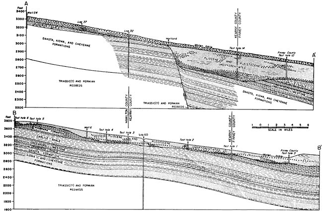
Figure 8--C, North-south geologic profile across western Kearny County; D, North-south geologic profile across western Hamilton County. A larger version of this figure is available.
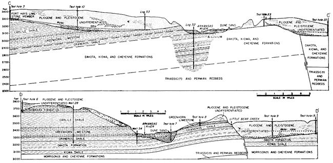
Table 2--Generalized section of the geologic formations in Hamilton and Kearny counties.
| System | Series | Formation | Member | Thickness (feet) |
Physical character | Water supply |
|---|---|---|---|---|---|---|
| Quaternary | Pleistocene and Recent |
Alluvium | 0-100 | Coarse sand and gravel containing silt and clay. | Yields very large supplies of relatively hard water to wells in the Arkansas valley. Supplies more water to wells than any other water-bearing formation in Hamilton and Kearny counties. | |
| unconformable on older formations | ||||||
| Dune sand | 0-75 | Medium-grained, rounded quartz sand. | Lies above the water table and hence does not yield water to wells in this area but serves as a catchment area for rainfall. | |||
| unconformable on older formations | ||||||
| Loess | 0-15 | Silt containing fine sand and some clay. | Does not yield water to wells in Hamilton and Kearny counties. | |||
| unconformable on older formations | ||||||
| Pleistocene | Undifferentiated deposits |
0-300 | Consolidated and unconsolidated sands and gravels containing much silt arid some clay. Locally contains volcanic ash. | Yields moderate to large supplies of moderately hard water to domestic, stock, and irrigation wells in most of Hamilton and Kearny counties. | ||
| unconformity | ||||||
| Tertiary | Pliocene | Ogallala formation | 0-210 | Predominantly silt, but also sand, gravel, caliche, and clay. Lower part locally contains tan, brown, and green bentonitic clay. | Yields moderate to large supplies of moderately hard water to domestic, stock, and irrigation wells in parts of Hamilton and Kearny counties. | |
| unconformable on older formations | ||||||
| Cretaceous | Gulfian | Niobrara formation | Smoky Hill chalk | 0-125 | Soft shaly chalk. Only lower part exposed. | Yields moderate to large supplies of moderately hard water to domestic, stock, and irrigation wells in parts of Hamilton and Kearny counties. |
| Fort Hays limestone | 61 | Cream-colored chalky limestone containing dark-gray calcareous platy shale. | The lower part may yield very small quantities of water to a few wells in northwestern Hamilton County. | |||
| Carlile shale | Codell sandstone | 25 | Fine- to medium-grained sandstone and sandy shale. | Yields small quantities of water to a few wells in northwestern Hamilton County. | ||
| Blue Hill shale | 75 | Blue-black fissile shale containing calcareous concretions near the top. | Yields little or no water to wells in Hamilton and Kearny counties. | |||
| Fairport chalky shale | 147 | Calcareous shale in upper part. Basal part is thin-bedded chalky limestone containing gray shale partings. | Yields little or no water to wells in Hamilton and Kearny counties. | |||
| Greenhorn limestone | Bridge Creek limestone | 74 | Thin-bedded chalky limestone and gray limy shale. | Yields very small quantities of water to a few wells in northern Hamilton County. | ||
| Hartland shale | 23 | Gray limy shale. | Yields little or no water to wells in Hamilton and Kearny counties. | |||
| Lincoln limestone | 35 | Limy shale containing thin-bedded limestone. | Yields small quantities of water to a few wells in southern Hamilton County. | |||
| Graneros shale | 61 | Dark-gray fissile shale containing thin-bedded limestone in lower half. | Yields little or no water to wells in Hamilton and Kearny counties. | |||
| Dakota formation | 175± | Buff, brown, and tan irregularly-bedded fine-grained sandstone containing sandy shale, shale, and clay. | Yields moderate supplies of moderately hard water to domestic and stock wells in southern and northwestern Hamilton County. Near Coolidge the water is under sufficient pressure to cause it to flow. | |||
| ?? | ||||||
| Comanchean* | Kiowa shale | 125± | Dark-gray to black shale containing lenses of sandstone. | Yields little or no water to wells in Hamilton and Kearny counties. | ||
| local unconformity | ||||||
| Cheyenne sandstone |
100± | Gray and light-tan medium-grained sandstone. | Yields moderate quantities of moderately hard water to a few wells in the Arkansas valley near Coolidge. The water is under sufficient pressure to cause some of the wells to flow. | |||
| Jurassic | Morrison formation |
0-100 (?) | Bluish-green marl containing thin beds of gray and buff sandstones. | Yields little or no water to wells in Hamilton and Kearny counties. | ||
| unconformity | ||||||
| Triassic | Undifferentiated redbeds |
0-50 (?) | Buff and red fine-grained sandstone and red siltstone. | Yields little or no water to wells in Hamilton and Kearny counties. | ||
| unconformity (?) | ||||||
| Permian | Leonardian and Guadalupian* |
Undifferentiated redbeds |
1,550± | Red sandstone and siltstone containing beds of gypsum, anhydrite, and dolomite. | Yields little or no water to wells in Hamilton and Kearny counties. | |
| *The classification is that in use by the State Geological Survey of Kansas. | ||||||
Geologic History
The geologic history of the Hamilton-Kearny area is similar to that of much of the southern High Plains. The area is underlain by thick deposits (6,005 feet in the Stanolind Oil and Gas Company No. 1 Judd in northwestern Kearny County) of limestone, sandstone, shale, clay, sand, and gravel and smaller amounts of salt and gypsum. The character, appearance, and relationships of these rocks as studied in well cuttings and at outcrops reveal much of the geologic history of the region.
Paleozoic Era
Comparatively little is known of the early Paleozoic sediments in this area because only a few test holes have penetrated these beds. The Stanolind Oil and Gas Company No. 1 J. M. Judd well in northwestern Kearny County and the No. 1 Porter well in southwestern Hamilton County penetrated marine limestones and shales of Cambrian, Ordovician, Mississippian, Pennsylvanian, and Permian ages. This indicates that the area was covered by seas during much of the Paleozoic era. The apparent absence of deposits of Silurian and Devonian age probably indicates that this was a land area during that time. If any sediments were laid down at that time, they were removed by subsequent erosion, possibly during early Mississippian time. After Devonian time the area was again submerged and probably remained so during much of the Mississippian, the Pennsylvanian, and the early part of the Permian periods. During this time there were many invasions of the sea interrupted by relatively short periods of emergence. In late Permian time there probably was general emergence that produced shallow basins and broad mud flats in which the redbeds were deposited. The presence of thick deposits of gypsum and salt implies an arid climate in late Permian time.
Mesozoic Era
Triassic (?) Period
The oil-test holes in southwestern Hamilton County penetrated about 320 feet of redbeds, buff and tan sandstones, and gypsum that Norton (1939) believes to be of Triassic age. Similar deposits crop out in northwestern Oklahoma, in Morton County, Kansas, and at Two Buttes in southeastern Colorado. These deposits are very similar to the upper Permian sediments and probably were deposited under conditions not much changed from those that existed during late Permian time.
Jurassic (?) Period
Test hole 24 in southern Hamilton County penetrated a few feet of blue-green marl and gray to buff sandstone which probably is correlative with the Morrison formation of Jurassic age that crops out at Two Buttes, Baca County, Colorado. Similar beds were recognized by Norton (1939) in cuttings from the oil-test wells in southwestern Hamilton County. The character of these deposits, together with the nature of the fossils that have been taken from Morrison beds in other localities, indicates that during Jurassic time this area was part of a large land mass upon which the fluviatile Morrison beds were laid down. Subsequent erosion removed much of these beds.
Cretaceous Period
Sandstones of the Cheyenne formation were deposited over the entire area in early Cretaceous time. These deposits were laid down either by shallow-water marine deposition or by streams (Twenhofel, 1924, p. 19). Then followed an invasion of the sea and the deposition of a dark fossiliferous clay that formed the Kiowa shale. At the beginning of late Cretaceous time, sandstones and clays were laid down under both fluviatile and near-shore marine conditions. In some areas the sandstones contain salt water and marine fossils and are well stratified, but fossil plants found in the Dakota formation in other areas suggest a fresh-water origin. Moore (1933, p. 443) suggests that the Dakota formation is a stream-laid and sea-worked deposit.
Marine deposits of limestone, chalk, and shale were laid down in this area in late Cretaceous time. These deposits thicken toward the south, but are absent in the southernmost part of Hamilton and Kearny counties. The late Cretaceous sea probably covered this entire area, but the rocks deposited in them were in part removed by subsequent erosion. At the close of the Cretaceous period there were great orogenic movements that produced the Rocky Mountains and affected at least part of the High Plains section. During this time the Cretaceous and older beds probably were tilted to produce their present northward regional dip.
Cenozoic Era
Tertiary Period
After the tilting of the Cretaceous and older beds at the close of the Mesozoic era, there was a long period of erosion that truncated these Upper Cretaceous sediments, probably during very early Tertiary time. Some time later, but still in early Tertiary time, there was moderate folding which produced the Scott-Finney structural basin. At this time the Syracuse anticline, which is genetically related to the Scott-Finney basin, probably was beginning to form. The folding was followed by a period of erosion in which the trough of the Scott-Finney basin was deepened. Toward the close of Tertiary time, during the middle of the Pliocene epoch, aggrading and laterally shifting streams deposited the silts, sands, and gravels comprising the Ogallala formation. Subsequent erosion removed much of this material, however, in the Hamilton-Kearny area, particularly in the southern part.
Quaternary Period
Pleistocene epoch--Near the close of the Tertiary period or during early Pleistocene time there was renewed downwarping of the Scott-Finney basin as well as renewed folding of the Syracuse anticline accompanied by faulting. This period of deformation probably was the same as that which produced the major faulting in the Meade basin in Meade County, Kansas (Frye and Hibbard, 1941). Following the folding and faulting, there was a long period of deposition by aggrading and laterally shifting streams that produced thick deposits of silts, sands, and gravels resembling those of the Ogallala formation. These sediments probably were laid down by eastward-flowing streams carrying material from the Rocky Mountain region. The accompanying map (pl. 3) shows a deep valley in the bedrock trending east-southeastward along which much of this material probably was transported.
After these sediments were deposited, there were continued crustal movements resulting in subsidence of the area south of the river including further displacement in the fault along the Syracuse anticline. Much of the present topography owes its origin to this period of movement. At that time the scarp along Little Bear creek probably was formed, the sand-hills area subsided nearly to its present low level, and Arkansas river swung northeastward at a point near Hartland.
The structural movements in late Pleistocene time were accompanied by the formation of at least two and possibly more terraces along Arkansas river. One is 5 to 8 feet above the floodplain level and is locally called "second bottoms." It is well displayed south of Syracuse, northwest of Kendall, and north of Lakin. This terrace is underlain by coarse sand and gravel having a maximum known thickness of 125 feet in western Hamilton County. A second terrace, which is about 15 to 25 feet above the level of the flood plain, is exposed at the north edge of the sand hills area at many places in Hamilton and Kearny counties. It extends many miles southward under the sand hills in eastern Kearny County and in western Finney County. Test hole 19 in the southeastern part of T. 25 S., R. 35 W. (fig. 2) encountered more than 300 feet of very coarse sand and gravel, part of which probably represents this terrace deposit. At test hole 19, the terrace is covered by only a few feet of dune sand and the topography is relatively flat. The altitude of the top of the gravel deposit is approximately the same as that of the exposed part of the terrace nearly 6 miles to the north. Other test holes (20 and 21) farther south encountered similar deposits, the tops of which were at approximately the same altitude as that of the terrace. Remnants of a higher terrace are to be found north of Arkansas river in secs. 25 and 27, T. 23 S., R. 42 W. in western Hamilton County. These remnants are relatively thin and rest on Cretaceous bedrock. Remnants of this terrace have not been found east of Hamilton County, but some of the higher terraces in eastern Colorado may be of the same age.
In late Pleistocene time several events were begun that were continued, at least intermittently, into Recent time. Great dust storms deposited a blanket of loess over much of this area at that time. This activity probably was resumed several times, the last time being the period of dust storms in the last decade. Contemporaneous with or soon after the loess deposition, the said dunes were developed on the flat terrace plain south of Arkansas river. The shifting of these dunes has continued to the present time. The encroachment of the dunes. probably caused Bear creek to cease flowing into Arkansas river and may have been in part responsible for the shifting of the channel of Arkansas river in late Pleistocene or Recent time.
Recent epoch--Since Pleistocene time the area has undergone erosion that has formed much of the present topography. Many of the small intermittent streams have cut into or through Pleistocene sands and gravels and, therefore, probably are of late Pleistocene or of Recent age. Many of these streams, particularly those in northern Kearny County, terminate in broad, rounded, shallow depressions or sink holes. Such depressions are from a few yards to half a mile in diameter and may or may not contain water. Most of them hold water for long periods after heavy rainfall until the water has evaporated or moved downward to the water table. A few such depressions in the Scott-Finney basin are near enough to the water table to support a marshy type of vegetation. There are also many sinks or depressions in southwestern Hamilton County along the southern margin of the Syracuse anticline.
The origin of sinks is problematical. It has been suggested by Smith (1940, p. 171) that
these depressions are probably a result of subsidence due to solution of salt or gypsum beds in Permian or early Mesozoic formations, or possibly, in the case of the Scott-Finney depression, of calcareous beds in the Cretaceous.
It was suggested by Johnson (1901, p. 711) that
the innumerable upland basins, especially where the floor is Cretaceous to great depths, are clearly to be ascribed to grain-by-grain processes of readjustment and compacting, at work within the Tertiary only.
The depressions in the Kearny upland are underlain by relatively thick deposits of Tertiary and Quaternary age and probably were formed by solution, readjustment, and compacting within Tertiary and Quaternary sediments. Most of those in the southwestern part of Hamilton County are near the fault on the southern side of the Syracuse anticline. Their linear trend is shown clearly on aerial photographs. The most recent of these depressions is the one that began to sink on December 18, 1929 (Bass, 1931), at the NE cor. sec. 22, T. 25 S., R. 43 W., in western Hamilton County. Originally it had a diameter of about 60 feet, was 40 to 50 feet deep, and contained a shallow pool at the bottom. In 1941 the diameter had increased by caving until it was 150 to 200 feet. At this time it was filled with water to a level about 15 feet below the western rim. Soon after a new cave-in in 1931, Landes (1931, p. 708) found about 10 feet of Graneros shale exposed in the eastern wall and concluded that the sink probably was caused by solution of salt or gypsum in pre-Dakota sediments, possibly those of Triassic (?) age. All of the sinks along the fault probably were formed in the same manner. The movement along the fault may have brought water-bearing beds into contact with beds of salt or gypsum, or at least it may have developed channelways along which water could move to gain contact with the soluble gypsum or salt. The age of the soluble beds probably is upper Permian, because oil tests in this area encountered only a small amount of soluble material in the Triassic (?) beds.
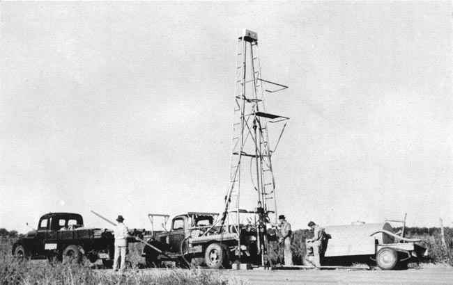
Plate 6--Portable drilling machine owned by State and Federal Geological Surveys, used in drilling test holes in Hamilton and Kearny counties.
Prev Page--Geography || Next Page--Ground-Water Occurrence
Kansas Geological Survey, Geology
Placed on web Oct. 25, 2007; originally published December 1943.
Comments to webadmin@kgs.ku.edu
The URL for this page is http://www.kgs.ku.edu/General/Geology/Hamilton/04_geol.html