![]()
Prev Page--Utilization, Quality || Next Page--Well Records, Hamilton
Geologic Formations and their Water-bearing Properties
Permian System
Undifferentiated Redbeds
Character--The Permian redbeds are not exposed in Hamilton and Kearny counties and no detailed lithologic description can be given because the only available data concerning these beds are the logs of oil and gas tests drilled in this area. The redbeds encountered in oil and gas tests in Hamilton and Kearny counties consist principally of red siltstone and sandstone with interbedded salt, gypsum, anhydrite, and dolomite.
Distribution and thickness--The Permian redbeds underlie all of Hamilton and Kearny counties, but the nearest outcrops of these beds are in Texas County, Oklahoma, and in Meade and Clark counties, Kansas. The only data concerning the thickness of the beds in the Hamilton-Kearny area are the logs of oil and gas tests. The Wood Oil Company No. 1 Ranson well, in sec. 5, T. 26 S., R. 41 W., encountered more than 1,500 feet of red siltstone, sandstone, salt, and gypsum. Most of these beds are of Permian age but the uppermost beds may be of Triassic age. Norton (1939, p,. 1,764) stated that, about 1,550 feet of redbeds was encountered by the No. 1 Porter well in sec. 30, T. 25 S., R. 41 W. The oil-test wells of the Stanolind Oil and Gas Company in northwestern Kearny County encountered 1,050 to 1,130 feet of Permian redbeds.
Age and correlation--On a basis of the study of well logs, it has been determined that the Permian redbeds underlying Hamilton and Kearny counties include representatives of all the formations recognized by the State Geological Survey of Kansas from the lower Ninnescah shale to the Taloga formation.
Water supply--Little or no water is obtained from these beds by wells in Hamilton and Kearny counties. Farther south, in Morton County, water under artesian pressure is obtained from Permian redbeds, but the relatively high mineral content makes it unsuitable for most uses.
Triassic (?) System
Undifferentiated Redbeds
Redbeds of Triassic age crop out in Morton County, Kansas, Texas and Cimarron County, Oklahoma, and at Two Buttes near the Prowers-Baca county line in southeastern Colorado. The outcrop at Two Buttes, which is about 40 miles southwest of the southwestern corner of Hamilton County, consists of about 240 feet of massive, cross-bedded, medium-grained, friable sandstone (Saunders, 1934, p. 865). It is probable that at least a part of this formation extends into western Hamilton County. A part of the redbeds encountered in the oil-test wells in southwestern Hamilton County may be of Triassic age. These beds yield no water to wells in Hamilton and Kearny counties.
Jurassic (?) System
Morrison (?) Formation
Deposits of Morrison age probably underlie most of Hamilton County and at least a part of Kearny County. The No. 1 Porter well in southwestern Hamilton County penetrated more than 200 feet of sediments which are probably equivalent to the Morrison beds that crop out, at Two Buttes in southeastern Colorado. Test hole 24, in the SE corner sec. 36, T. 26 S., R. 40 W., encountered nearly 100 feet of similar deposits (log 24). The deposits consist primarily of blue-green, rusty-brown, and maroon clay shales and marls containing beds of buff sandstone. These beds thin toward the east and are absent in eastern Finney County. They extend northward for many miles and have been encountered in wells in Norton County, Kansas, near the Kansas-Nebraska line. These deposits yield little or no water to wells in Hamilton and Kearny counties. Water probably could be obtained from the sandstones in this formation, but adequate quantities generally can be obtained from the overlying Cretaceous sandstones.
Cretaceous SystemCragin (1886, 1889, 1895) classified the Cretaceous sediments of southern Kansas into the Cheyenne sandstone, the Kiowa shale, and the Dakota sandstone, named in ascending order. A little later, Gould (189S) redefined the Kiowa and Dakota of this area and described the Medicine beds between the Kiowa shale and the Dakota sandstone. Stose (1912) classified equivalent rocks in eastern Colorado into the Purgatoire formation, containing a lower sandstone member and an upper shale member, and the Dakota sandstone. In 1920, Darton (p. 2) subdivided the Cretaceous rocks that lie below the Graneros shale in western Kansas into the Cheyenne sandstone, the Kiowa shale, and the Dakota sandstone. Twenhofel (1924, pp. 12-30) used the terms Cheyenne sandstone, Belvidere formation, and "Dakota" formation for the Cretaceous sediments of southern Kansas, and retained the term Kiowa for the lower shale member of the Belvidere formation. In describing similar beds in Hamilton County, Bass (1926, pp. 59, 73-76) used the term Dakota sandstone for all sediments between the Permian redbeds and the Graneros shale. He recognized, however, that part of these sediments probably were equivalent to the Purgatoire formation of eastern Colorado. Lee (1927, p. 17) correlated the Purgatoire formation and the Dakota sandstone of southeastern Colorado with sediments designated by him as the Dakota group at the Bellvue section in northern Colorado. Elias (1931, p. 28; 1937, p. 10) classified equivalent sediments in western Kansas as the Dakota group. In 1931, Tester (1934, pp. 234-283) applied the name Dakota stage to the succession of strata lying between the Graneros shale and Pennsylvanian sediments at the type locality of the Dakota in eastern Nebraska. Saunders (1934, pp. S62-865) divided similar sediments of the Two Buttes area of southeastern Colorado into the Purgatoire formation and the Dakota sandstone. Schoff (1939, pp. 54-57) classified the Cretaceous sediments of western Oklahoma into the Purgatoire formation, including the Cheyenne sandstone and the Kiowa shale members, and the Dakota sandstone.
The term Dakota group has formerly been used by the State Geological Survey of Kansas (Moore and Landes, 1937; Moore, 1940, p. 40) to include all Cretaceous strata that lie below the Graneros shale. The name Cockrum sandstone was applied by Latta (1941, p. 70) to the upper sandstone member of the Dakota group in Stanton County, and was also used in Morton County by McLaughlin (1942, p. 70). The beds formerly included in the Dakota group were studied in detail over their outcrop area in central and north central Kansas by Plummer and Romary (1942), and the terms Cheyenne sandstone, Kiowa shale, and Dakota formation (named in ascending order) were adopted to include all Cretaceous strata that lie below the Graneros shale. The term Dakota formation is used in preference to Dakota sandstone because in most of the outcrop area of these beds in Kansas the dominant rock constituents are clay, shale, and siltstone rather than sandstone. In central and north central Kansas the Dakota formation is subdivided into the Terra Cotta (lower) and Janssen (upper) members. These members cannot be clearly recognized in Hamilton and Kearny counties, however.
In collecting the data for this report, most of the field studies and observations were of the principal water-bearing formations. Therefore, the geology of the Cretaceous deposits that overlie the Dakota formation has been largely drawn from Darton (1920) and from Bass (1926). Bass made a detailed study of the Cretaceous formations in Hamilton County in 1926.
Cheyenne Sandstone
Character--The Cheyenne sandstone is not exposed at the surface in Hamilton and Kearny counties. Where it crops out in adjacent areas in southeastern Colorado and southern Kansas it is composed principally of white to yellow quartz sandstone of medium to coarse grain but contains subordinate amounts of shale. In some areas the sandstone is conglomeratic near the base. The character of the materials that comprise this formation in Hamilton and Kearny counties is known only from records of wells that penetrate these beds. The logs indicate that in this area the Cheyenne is composed principally of a fine- to medium-grained sandstone which ranges in color from white to buff.
Distribution and thickness--The Cheyenne sandstone underlies all of Hamilton and Kearny counties. In this area it is overlain by the Kiowa shale and it unconformably overlies older formations, principally the undifferentiated Permian redbeds and locally the Morrison (?) formation or the Triassic (?) redbeds. The thickness of the Cheyenne sandstone is somewhat variable. Test hole 25 (log 95) penetrated 54 feet of Cheyenne and in test hole 24 (log 24) it was 33 feet thick. Sixty-six feet of the formation was encountered in the old railroad well at Kendall (log 32). Some drillers have reported as much as 100 feet of Cheyenne sandstone encountered by wells in this area. This thickness, however, probably includes the Morrison (?) formation. The thickness of the Cheyenne sandstone is 15 to 50 feet in Cimarron County, Oklahoma; 50 feet at Two Buttes, in southeastern Colorado; and 10 to 55 feet in the vicinity of the type locality in Kiowa and Comanche counties, Kansas.
Age and correlation--No fossils were obtained from the Cheyenne sandstone in Hamilton and Kearny counties, so its age must be determined by correlation with sandstones that crop out in adjacent areas. These beds are lithologically very similar to the lower part of the Purgatoire formation of southeastern Colorado, northeastern New Mexico, and western Oklahoma. They also closely resemble the Cheyenne sandstone of Kiowa and Comanche counties, Kansas. Its stratigraphic position below a dark shale that is believed to be correlative with the Kiowa shale and with the upper shaly part of the Purgatoire formation also aids in its correlation.
Marine fossils collected from the Cheyenne sandstone in Cimarron County, Oklahoma, are believed by Bullard (1928, P. 116) to be of Washita (Lower Cretaceous) age. Marine pelecypods collected by Schoff (1939, p. 55) in the Cheyenne sandstone in the Red Point district in Texas County, Oklahoma, were identified by T. W. Stanton as representing a horizon near the base of the Washita group (Lower Cretaceous).
Origin--The presence of marine fossils in the Cheyenne sandstone in Texas and Cimarron counties, Oklahoma, implies a marine origin for these beds in that area. In Kiowa and Comanche counties, Kansas, however, discontinuous bedding, cross lamination, apparent absence of marine fossils, and presence of land plants seem to indicate a nonmarine origin. Twenhofel (1924, pp. 19, 20) states that the vegetable matter appears to have floated in and that the Cheyenne sandstone in this area is also marine.
Water supply--Moderate quantities of water under artesian pressure are obtained from the Cheyenne sandstone by wells in the vicinity of Coolidge. In wells that penetrate these beds the water rises nearly to or above the land surface. All but one of the flowing artesian wells in the Coolidge area obtain water from the Cheyenne sandstone at depths of 285 to 325 feet. A few wells penetrate these beds at Syracuse and at Kendall. Water from the Cheyenne sandstone rises to about 45 feet below land surface in well 78 at Syracuse, whereas the static water level in a near-by well (77) that obtains water from the alluvium is 25 feet below land surface. Water could be obtained from the Cheyenne sandstone in almost any part of Hamilton and Kearny counties, but the Cheyenne is everywhere overlain by the Dakota formation which would yield adequate quantities of water for most uses. The great depth at which the Cheyenne sandstone lies also prevents much development of its water supply. It ranges in depth below land surface from about 250 feet in the Syracuse upland to about 900 feet in the northern part of the Kearny upland.
Water from the Cheyenne sandstone is moderately hard and is similar to water from the Dakota formation. Generally it is somewhat softer than water from the Dakota formation and from Tertiary and Quaternary sediments.
Kiowa Shale
Character--The Kiowa shale does not crop out in Hamilton and Kearny counties, so its character in this area can be determined only by the study of cuttings from test holes. As a result of such studies, the Kiowa shale in this area was found to consist principally of dark-gray to black fissile shale containing lenses of fine sand. The beds are in part calcareous. The Kiowa shale is, in most places, conformable on the Cheyenne sandstone but there are some apparent local disconformities.
Distribution and thickness--The Kiowa shale probably underlies the entire Hamilton-Kearny area. It has been encountered by every test hole that has been drilled to Triassic (?) or Permian redbeds. The thickness of the Kiowa shale in this area is quite variable. Wells have penetrated as little as 49 feet of these beds (well 57 near Coolidge) whereas as much as 131 feet of Kiowa shale was encountered in test hole 24 (log 24). The thickness of these beds is 122 feet at Syracuse and 58 feet at Kendall. The maximum reported thickness of the Kiowa shale is 150 feet at the type locality in Kiowa county, Kansas.
Age and correlation--No fossils were obtained from the shale in the Hamilton-Kearny area, so it must be correlated on a basis of lithology and stratigraphic position. These beds appear to correlate with the Kiowa shale of Kiowa and Comanche counties, Kansas.
Water supply--The Kiowa shale yields little or no water to wells in Hamilton and Kearny counties.
Dakota Formation
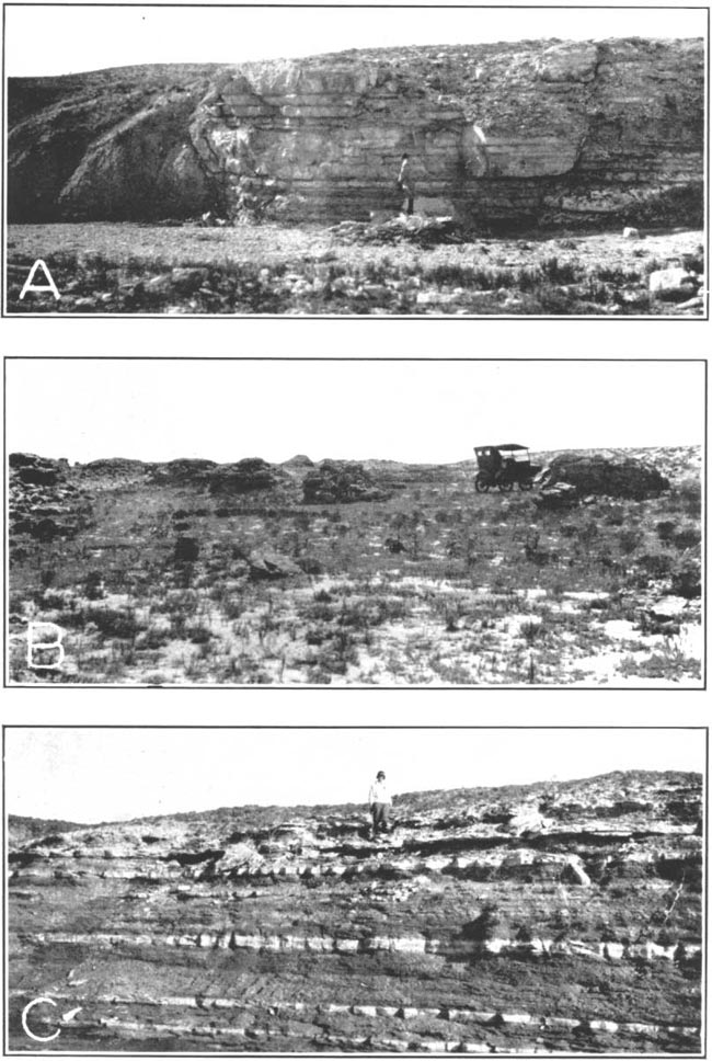
Character--The character of the Dakota formation in this area was determined by a study of the outcrops and of cuttings from test holes. The uppermost 25 or 30 feet of the formation crops out in this area and is composed principally of gray to buff, fine-grained, irregularly-bedded sandstone and varicolored clay. The sandstone beds near the top of the formation grade into the overlying Graneros shale. They are ferruginous and very fine-grained and in places are strongly ripple-marked and cross-bedded. The top sandstone bed is a light-tan massive bed about 3 feet thick that weathers into large blocks. It is this bed that is commonly quarried for building stone in southern Hamilton County. Some of the sandstone layers are rusty brown and contain many small ironstone concretions and lignitic zones. In the vicinity of Hartland, the uppermost sandstone of the Dakota formation has been cemented by silica to form a very hard quartzitic rock that weathers into smooth rounded boulders. The rock weathers to tan or brown, but it is white to gray on unweathered surfaces.
The sandstones of the Dakota formation are interbedded with and interfinger with clay and silty clay. Data obtained from well cuttings indicate that most of the sandstone beds are near the top and near the base of the Dakota formation. About 40 to 45 percent of the formation is made up of clay. The clay is varicolored, the most common colors being buff and tan. A section of the Dakota formation measured in southern Hamilton County follows:
| Section of the Dakota formation in sec. 24, T. 26 S., R. 41 W. | Feet | |
|---|---|---|
| 9. | Clay, buff to rusty | 1.0 |
| 8. | Clay, gray to buff, with concretionary nodules near the base | 0.8 |
| 7. | Sandstone, fine, thinly bedded, gray | 1.1 |
| 6. | Sandstone, fine, irregularly bedded, gray, and some clay | 2.0 |
| 5. | Sandstone, fine, hard, thinly bedded, gray | 0.9 |
| 4. | Clay, compact, gray to purple, containing ironstone concretions | 1.2 |
| 3. | Clay, fractured, light gray | 1.2 |
| 2. | Clay, nodular, yellowish to buff | 1.4 |
| 1. | Sandstone, fine, soft, buff to yellow | 3.0 |
| Base not exposed | ||
| Total | 12.6 | |
Upon microscopic examination, it was found that specimens of sandstone from the Dakota formation are composed principally of fine-grained quartz sand containing very fine-grained sand and some silt. The clay beds are composed of clay with some silt and very fine sand. The cementing material is principally iron oxide, but the sandstone from the outcrop near Hartland is cemented with silica.
Distribution and thickness--Beds belonging to the Dakota formation underlie all of Hamilton and Kearny counties. The upper 25 or 30 feet of this formation crop out in a few small areas in southern Hamilton County and in the vicinity of Hartland in Kearny County (pl. 1).
The thicknesses of the Dakota formation encountered by wells in this area range from 130 feet in test hole 24 (log 24) in southern Hamilton County to 314 feet at Kendall. Other thicknesses encountered were 142 feet near Coolidge (well 57) and 165 feet at Syracuse (log 33).
Age and correlation--For a discussion of the age and correlation of the Dakota formation, see pages 116 and 117.
Structure--The structure of the Dakota formation in this area was studied by Bass (1926), who made a contour map showing the structure of the Dakota in Hamilton County and one showing the structure of the Dakota in most of western Kansas. The map showing the structure in Hamilton County was based on outcrops of the Cretaceous rocks and on records of water wells. The altitudes were in part determined with an aneroid barometer and in part taken from the topographic maps of the Syracuse and Lakin quadrangles. The map shows two elongated domes in southern Hamilton County.
Smith (1940) recognized the possibility of a fault on the southern margin of the structure. His conclusions were based primarily on physiographic evidence. He stated (pp. 136, 137) that:
It may be observed that the general level of the plains declines slightly from north to south across the Arkansas valley, from the Kearny area to the Syracuse upland, then drops abruptly to the Stanton area in southern Hamilton County, thereafter to rise regularly and very gradually toward the Oklahoma line, but without regaining its full northerly height. The topographic maps show the contours in the Stanton area to trend slightly west of north up to the base of the Syracuse upland, where they bend abruptly east, thus marking a pronounced topographic break. Conceivably, this break may represent a product either of erosion or of deformation. A study of the size and spacing of streams in the Stanton area, however, soon leads to the conclusion that post-Ogallala erosion has been very moderate in amount. The streams are few and far apart, and feeble in comparison with the Arkansas, which has carved out a valley that is small in comparison with the lower part of the Stanton area. Furthermore, the westward indentation of the contours in the Stanton area varies inversely with the strength of the traversing streams. The lowest part of the area lies not along Bear creek, a moderately vigorous stream, but along its northern branch, a much shorter and feebler water course. These relations are incompatible with any hypothesis attempting to explain the present topography as a result of dissection and removal of a once thicker Ogallala fill aligned with the top of the Syracuse upland. It is therefore concluded that the observed topographic anomalies represent the result of an abrupt and asymmetrical downwarp of the original Ogallala surface, the trough of the flexure being close against the base of the Syracuse upland.
The rectilinear trend of the north branch of Bear creek (Syracuse topographic sheet) suggests that the flexure was broken by a fault. Northwest of the junction of this branch with the main stream for about 15 miles the course of the tributary is conspicuously linear in comparison with the winding course of Bear creek itself. The trend veers from about N 70° W at the southeast to about N 50° W toward the northwest. On aerial mosaics the linear character of the valley is even more conspicuous and the valley is seen to be marked by a series of depressions, presumably of solutional origin, and localized by the fault. A short en echelon fault at the northwest is suggested by a linear tributary valley, also marked by depressions, one of which was formed in historic times.
The presence of a fault was proved conclusively by Latta (1941). A test hole (log 25) was drilled on the Hamilton-Stanton county line at a point about 1.2 miles southeast of an outcrop of the Dakota formation. In this test hole the Dakota formation was encountered at a depth of 230 feet. The altitude of the top of the Dakota formation is more than 300 feet higher at the outcrop than in the nearby test hole.
The accompanying map (fig 17) shows the structure of the Dakota formation in Hamilton and Kearny counties. The data are based principally on outcrops of Cretaceous rocks, records of test holes drilled by the State and Federal Geological Surveys, records of a few water wells, and records of oil and gas test wells. Altitudes of the test holes were determined with an alidade. The altitudes of the top of the Dakota formation in the area south of the fault may be incorrect because a part of the Dakota formation may have been removed by post-Cretaceous erosion. If this error could be corrected, however, the map would be only slightly changed. The trend of the fault was determined in several ways. In southwestern Hamilton County the linear nature of Little Bear creek and of the sink holes suggested its location. Along the southern margin of the Syracuse upland there are outcrops of Cretaceous formations, and in spite of the fact that the regional dip of the Dakota formation is toward the north and east the Cretaceous beds do not crop out a few miles south of the Syracuse upland where the altitude is 50 to 100 feet lower. Also, assuming a uniform northeastward regional dip, the Dakota formation should crop out in the sand-hills area in western Kearny County. Instead, it is encountered in wells in this area at depths of 100 to 400 feet.
Figure 17--Map of Hamilton and Kearny counties showing the structure of the Dakota formation. Heavy dashed line indicated the probable extent to the fault.
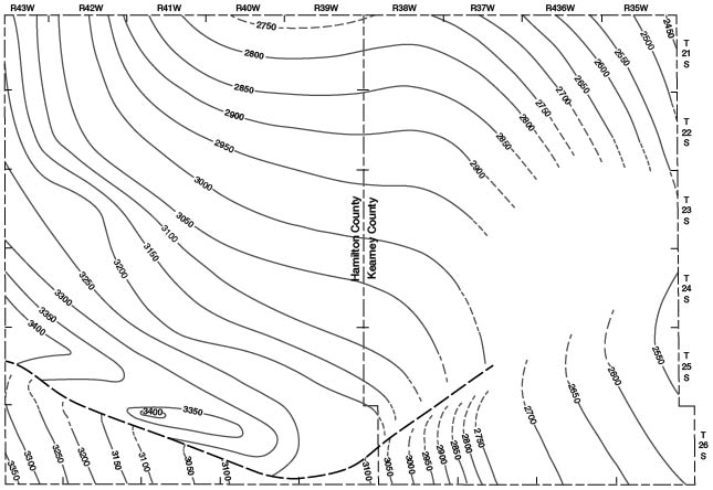
The fault (fig. 17 and pl. 3) probably trends northeastward from southwestern Kearny County and merges into the structure that forms the west side of the Scott-Finney depression. This would account for the fact that a test hole (log 48) 5 miles east of the outcrop of the Dakota formation near Hartland failed to encounter these beds even though it was drilled to a depth of 297 feet. The altitude of the test hole was about 30 feet lower than the top of the Dakota formation at the outcrop.
A smaller flexure is also present in northwestern Kearny County. It is along this structure that oil was recently discovered.
Water supply--Sandstones of the Dakota formation are important water-bearing beds in this area. They yield water to most of the wells in the Syracuse upland area (fig. 18), in the Arkansas valley in Hamilton County, and in the western part of the Kearny upland.
Figure 18--Map of Hamilton and Kearny counties showing areas in which the principal water-bearing formations supply water to wells. A, little or no water available to wells (except at great depths); B, most wells obtain water from the Ogallala formation; C, most wells, obtain water from the alluvium; D, most wells obtain water from the Dakota formation; E, most wells obtain water from undifferentiated Pleistocene deposits.
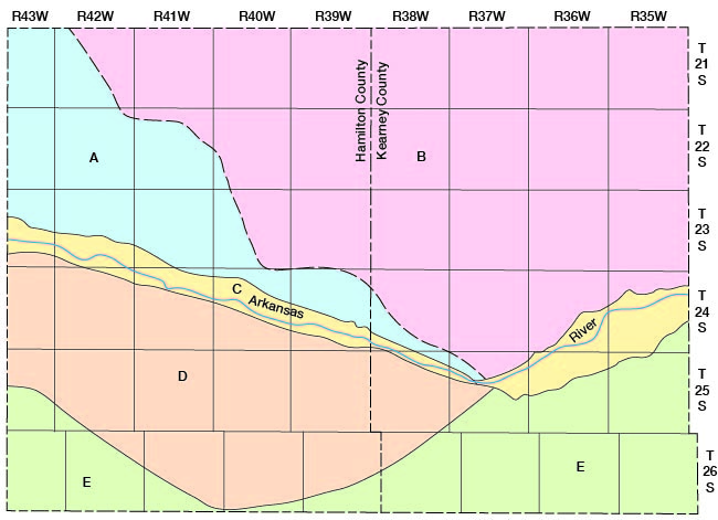
In the Syracuse upland, wells encounter the Dakota formation at depths of 50 to 300 feet. The water in these wells generally rises under artesian pressure to a level about 100 to 200 feet below land surface. In some parts of this upland area the sandstones of the Dakota formation are relatively impermeable and yield little or no water to wells; however, an adequate supply generally can be obtained for domestic and stock use.
In the Arkansas valley in Hamilton County many deep wells have been drilled to the Dakota formation to obtain water that is softer than the water in the alluvium. The formation is encountered at depths of 50 to 125 feet and the water rises under artesian pressure to a level near the land surface. In the vicinity of Coolidge, two sandstone horizons are encountered in the Dakota formation. Water from the first zone, which is 50 to 105 feet below land surface, rises to a level somewhat below the static level of the water in the alluvium. The second zone is encountered at a level about 150 feet below the top of the formation. Water from these beds generally will rise nearly to the land surface. One flowing well (61) in the vicinity of Coolidge obtains its water from these beds.
In the western part of the Kearny upland, a few wells are supplied with water from the Dakota formation. These wells range in depth from 400 to 850 feet and the water rises to a level about 300 to 400 feet below land surface. The great depth at which the Dakota formation lies in this area prevents extensive development of water supplies from these beds.
Generally, the sandstones of the Dakota formation are moderately permeable and yield adequate quantities of water for most domestic and stock uses, but in a few localities little or no water can be obtained from them. Well 11 when pumping at the rate of only a few gallons a minute has a draw-down of more than 375 feet because the sandstone at this point probably is tightly cemented, preventing the water from moving freely through it. Where the sandstones are cemented with silica, probably little or no water can be obtained from them. In such places the underlying Cheyenne sandstone generally will supply adequate water for most uses.
Water from the Dakota formation is relatively hard and generally contains enough fluoride to be harmful to children's teeth. The average water from the Dakota formation, based on 31 analyses from wells in Hamilton, Gray, Ford, Stanton, and Morton counties, contains about 395 parts per million of dissolved solids and has a hardness of about 215 parts per million. The fluoride content of these samples averaged about 2.2 parts per million. Water from the Dakota formation in Hamilton County had an average fluoride content of 2.0 parts per million. The ratio of the sodium content to total amount of calcium, magnesium, and sodium is relatively high in water from the Dakota formation, and sodium constituted 79.5 percent of the total bases in one sample (29).
Graneros Shale
Character--The Graneros shale was defined by Gilbert (1896) as a laminated argillaceous shale 200 to 210 feet thick. It was named from a creek in the northern part of the Walsenberg quadrangle in south central Colorado. In the Hamilton-Kearny area the Graneros shale comprises about 60 to 65 feet of gray-black fissile argillaceous shale with a 5- to 16-inch bed of bentonitic clay about 10 feet below the top of the formation. At 20 to 22 feet above the base of the formation are thin-bedded fossiliferous limestones that weather a rusty brown. The formation is sharply separated at the top from the limestones of the Greenhorn formation (pl. 10) but it grades into the underlying Dakota formation.
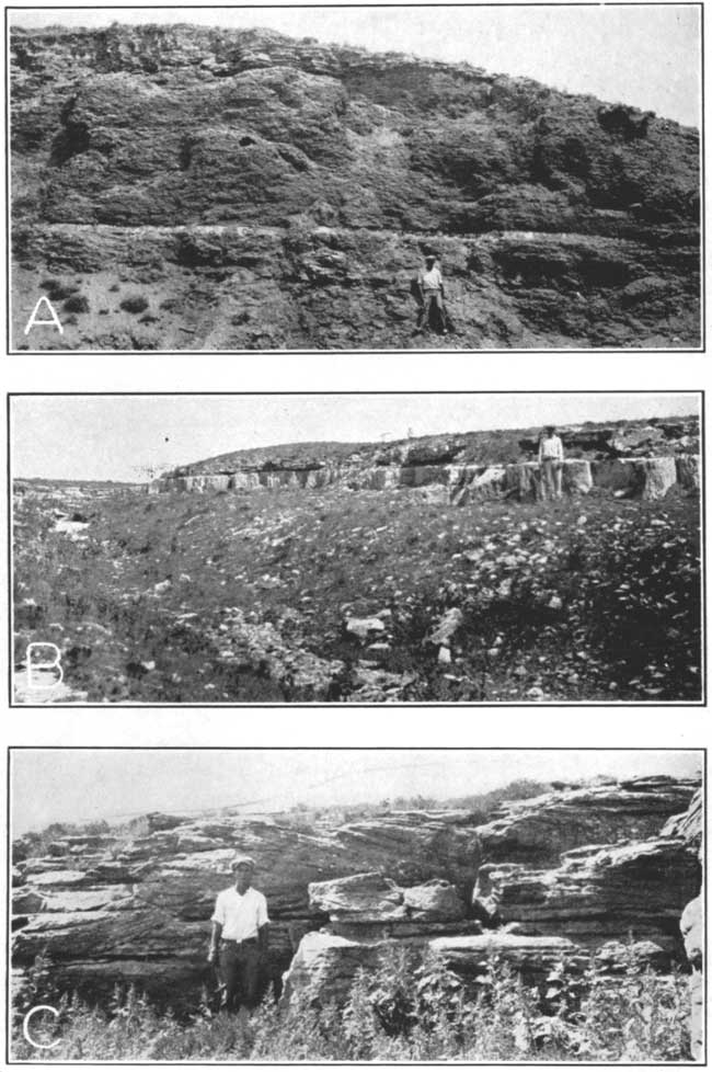
Plate 10--A, Graneros shale capped by basal beds of the Lincoln limestone member of the Greenhorn limestone in cut near Amazon headgate in Kearny County; B, Massive sandstone bed at top of the Dakota formation in sec. 27, T. 26 S., R. 41 W.; C, Cross-bedding in the upper part of the Dakota formation in sec. 17, T. 26 S., R. 41 W. (Photographs by N.W. Bass).
Distribution and thickness--The Graneros shale underlies all but the southern part of the Hamilton-Kearny area (pl. 3). It crops out in small areas along the sides of the Syracuse upland and on the northern side of Arkansas river between Hartland and Syracuse.
The thickness of the Graneros shale increases toward the west. It generally is less than 40 feet thick in Russell County, 50 feet thick in Hodgeman County, 61 feet thick in Hamilton County, and 200 feet thick in Otero County, Colorado (Dane, Pierce, and Reeside, 1937). The overlying Greenhorn limestone thins toward the west, indicating that the Graneros shale thickens at the expense of the Greenhorn limestone.
Water supply--The Graneros shale is relatively impermeable and yields little or no water to wells in Hamilton and Kearny counties.
Greenhorn Limestone
The Greenhorn limestone was differentiated as a formation by Gilbert (1896, pp. 564, 570), who named it from Greenhorn station south of Pueblo, Colorado, and from Greenhorn creek. At the type locality the formation consists of 25 to 40 feet of alternating beds of fine-grained compact, pale bluish-gray limestone and light-gray, laminated, calcareous shale. In Hamilton and Kearny counties the formation consists of about 132 feet of calcareous shale interbedded with thin layers of chalky and crystalline limestone and bentonitic clay. The formation merges into the overlying Fairport chalky shale member of the Carlile shale and is sharply defined from the Graneros shale which it conformably overlies. The thickness of the formation decreases from about 130 feet in Hamilton County to about 40 feet at the type locality. In this area, the Greenhorn limestone is commonly divisible into three members: the Lincoln limestone member, the Hartland shale member, and the Bridge Creek limestone member (named in ascending order).
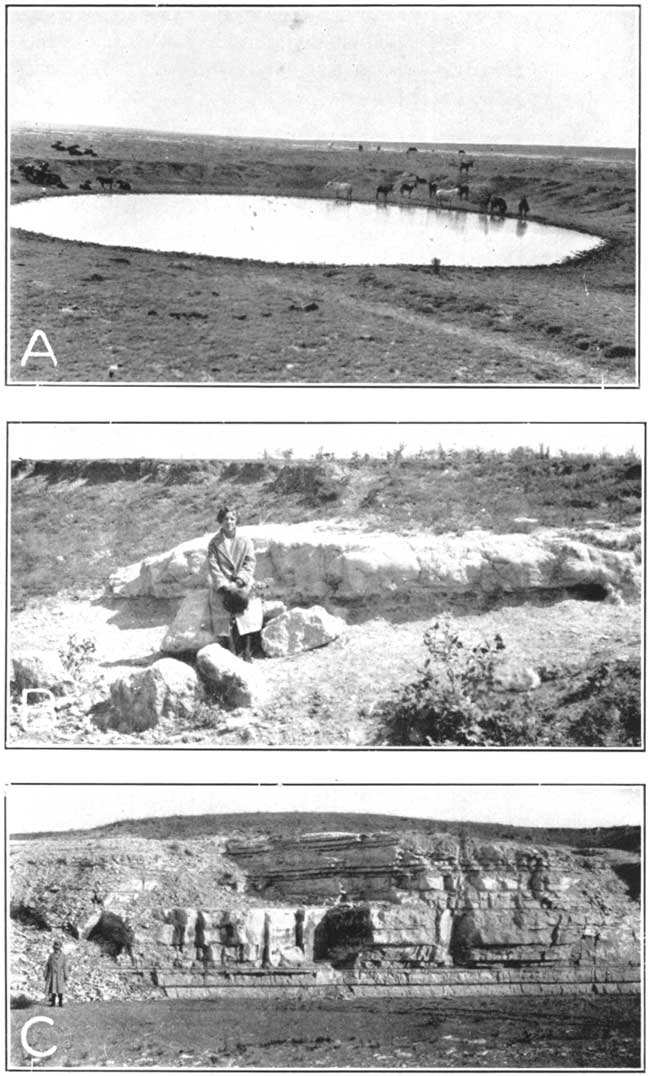
Lincoln limestone member--The basal 35 feet of the Greenhorn limestone in this area is called the Lincoln limestone member. The Lincoln limestone was named by Logan (1897, p. 216) from the city of Lincoln in Lincoln County, north central Kansas. It was adopted as the basal member of the Greenhorn limestone by Rubey and Bass (1925). The member consists predominantly of calcareous finely-banded shale with thin beds (1 to 4 inches thick) of hard, limestone that emit a petroliferous odor on fresh fracture. The limestone beds are gray but weather to brown. They are most abundant at the top and near the base of the member. The uppermost beds form the cap rock of a bench along the north side of Arkansas river between Hartland and Kendall (pl. 11). The Lincoln limestone member underlies all of the Hamilton-Kearny area north of Arkansas river as well as much of the Syracuse upland. These beds yield small quantities of water to a few wells in southern Hamilton County and they probably are the source of part or all of the water in the sink hole south of Coolidge.
Plate 11--A, View of bluffs north of Arkansas river west of Hartland showing the Hartland shale member overlain by the lowermost beds of the Bridge Creek limestone member of the Greenhorn limestone; B, Lowermost beds of the Smoky Hill chalk member of the Niobrara formation in sec. 3, T. 22 S., R. 43 W.
Hartland shale member--The type locality of the Hartland shale member is in western Kearny County between Hartland and Kendall (Bass, 1926, p. 69). The beds are exposed in the bluffs along the north side of Arkansas river (pl. 11). In this area the shale forms the gentle slopes between the lowermost beds of the Bridge Creek Limestone member and the uppermost beds of the Lincoln limestone member. The Hartland member consists of 23 feet of gray calcareous shales containing many thin beds of bentonitic clay which range in thickness from one-fourth inch to 2 inches. There are also a few very thin lenses of dark-gray fossiliferous limestone, none of which exceeds one inch in thickness. The Hartland shale underlies all of the Hamilton-Kearny area that is north of Arkansas river. The shale is relatively impermeable and yields little or no water to wells in that area.
Bridge Creek limestone member--The Bridge Creek limestone member was named by Bass (1926) after Bridge creek which enters the Arkansas valley about 2 miles west of Medway in western Hamilton County. It consists of 74 feet of interbedded calcareous shale and chalky limestone. The member is about four-fifths shale. The limestone beds range in thickness from 1 inch to 10 inches and are somewhat equally spaced (pl. 12). Interbedded with the limestone and shale are several beds of bentonitic clay ranging in thickness from one-fourth inch to 5 inches. Fossils are abundant in the upper two-thirds of the member. The limestone beds that lie between 40 and 50 feet above the base of the member are composed almost entirely of fossil shells of Inoceramus labiatus, a characteristic species of the Greenhorn limestone.
Plate 12--A, Fault in sec. 29, T. 22 S., R. 42 W., Hamilton County. Fort Hays limestone member of the Niobrara formation on the right and Codell sandstone member on the left.; B, Calcareous concretions in the Blue Hill shale member of the Carlile shale in sec. 36, T. 22 S., R. 42 W.; C, A part of the Bridge Creek limestone member of the Greenhorn limestone in the east bank of Bridge creek in sec. 14, T. 23 S., R. 42 W. (Photographs by N.W. Bass.)
At the base of the Bridge Creek limestone member is a bed (1 foot thick) of limestone that is split near the middle by a thin shale parting. This double limestone bed, which is much more resistant to erosion than the underlying Hartland shale, forms the prominent scarp along the north side of Arkansas river west of Hartland and minor terraces are formed by several of the overlying beds. A section measured along Bridge creek northwest of Medway in Hamilton County follows:
| Section of Bridge Creek limestone member of the Greenhorn limestone in sec. 7, T. 23 S., R. 42 W. | Feet | Inches | |
|---|---|---|---|
| 32. | Shale, fissile, calcareous, dark gray | 1 | 4 |
| 31. | Limestone, chalky, white | 3 | |
| 30. | Shale, chalky, fissile, gray | 1 | 3 |
| 29. | Limestone, compact, cream-colored | 3 | |
| 28. | Shale, fissile, gray | 1 | 3 |
| 27. | Limestone, hard, platy, gray | 2 | |
| 26. | Shale, fissile, gray | 1 | 2 |
| 25. | Limestone, platy, gray | 2 | |
| 24. | Shale, calcareous, fissile, gray | 5 | 2 |
| 23. | Limestone, massive, white | 8 | |
| 22. | Shale, fissile, dark gray | 2 | 6 |
| 21. | Limestone, hard, compact | 5 | |
| 20. | Shale, fissile, gray | 1 | 3 |
| 19. | Limestone, compact, fossiliferous, gray | 7 | |
| 18. | Shale, fissile, gray | 1 | 2 |
| 17. | Limestone, platy, fossiliferous, gray | 6 | |
| 16. | Shale, fissile, dark gray; contains bentonitic clay at the top and base | 1 | 4 |
| 15. | Limestone, platy, hard, fossiliferous | 6 | |
| 14. | Shale, fissile, gray; contains bentonitic clay at the base | 1 | 3 |
| 13. | Limestone, platy, gray | 4 | |
| 12. | Shale, fissile, buff to gray | 1 | 6 |
| 11. | Limestone, thin-bedded, gray | 6 | |
| 10. | Shale, fissile, gray, containing limy zones | 1 | 8 |
| 9. | Limestone, chalky, compact, white | 10 | |
| 8. | Shale, fissile, gray | 3 | 2 |
| 7. | Limestone, chalky, white | 6 | |
| 6. | Shale, fissile, dark gray | 1 | 6 |
| 5. | Limestone, compact, white | 5 | |
| 4. | Shale, fissile, dark gray | 1 | 2 |
| 3. | Limestone, compact, white | 6 | |
| 2. | Shale, thinly bedded, gray | 1 | 6 |
| 1. | Limestone, compact, cream-colored | 6 | |
| Base not exposed | |||
| Total | 35 | 3 | |
The above section represents the upper part of the Bridge Creek limestone member. Bed 32 lies about 13 feet below the base of the Fairport chalky shale member of the Carlile shale.
According to Bass (1926, p. 69), the uppermost 25 feet of the Bridge Creek member is equivalent to the Pfeifer shale member of the Greenhorn limestone in Ellis County, Kansas. The lowermost beds are equivalent to the Jetmore chalk member of the Greenhorn limestone in Hodgeman County, Kansas. Bass believes that the thick limestone bed that lies 49 feet above the base of the Bridge Creek member (bed 23 in the above section) is equivalent to the topmost limestone bed of the Jetmore chalk member.
The Bridge Creek limestone member underlies all of northern Hamilton and Kearny counties and crops out on the northern side of the Arkansas valley between Hartland and Coolidge and along several of the tributaries of Arkansas river in the western part of the Kearny upland. These beds yield very little water to wells in the Hamilton-Kearny area.
Carlile Shale
The Carlile shale was named by Gilbert (1896, p. 565) from Carlile station and Carlile spring, about 21 miles west of Pueblo. At the type locality it consists of gray argillaceous shale 175 to 200 feet thick. The upper one-fourth contains sand, and the topmost part is a yellow friable sandstone. In the Hamilton-Kearny area it consists of shale that is noncalcareous, blue-black, and fissile in the upper 100 feet, becoming limy and light-colored in the lower part. The thickness of the formation in this area is about 250 feet. It underlies the northern half of the Hamilton-Kearny area. In this area the Carlile shale is commonly divisible into three members--the Fairport chalky shale member, the Blue Hill shale member, and the Codell sandstone member (named in ascending order).
Fairport chalky shale member--This member is poorly exposed in the Hamilton-Kearny area and only the lowermost beds have been carefully studied. The member was named from the city of Fairport in Russell County, Kansas, by Rubey and Bass (1925., p. 16). The Fairport member comprises about 150 feet of calcareous blue-black shale in the upper part which becomes lighter colored and more calcareous downward. Interbedded thin chalky limestones and limy shales make up the basal 35 feet. The upper three-fourths of the member is poorly exposed but its topographic expression indicates that it is principally shale containing a few thin shaly limestone beds. The lower one-fourth of the member consists of alternating calcareous shale and thin-bedded limestone. The limestones generally are light gray, chalky, and fossiliferous and are nowhere more than 6 inches in thickness. The member contains many thin layers of bentonitic clay which generally are from one-fourth inch to 1 inch in thickness. One bentonite bed 32 feet above the base of the member is 8 inches thick.
The Fairport chalky shale member crops out in several small areas along the tributaries to Arkansas river between Medway and Coolidge and north of Syracuse. These beds probably yield little or no water to wells in the Hamilton-Kearny area.
Blue Hill shale member--The Blue Hill shale member of the Carlile shale is made up predominantly of blue-black noncalcareous fissile clay shale and has a thickness of about 75 feet. Near the top of the member is a zone of calcareous concretions that range in diameter from a few inches to about 15 feet (pl. 12). The Blue Hill member grades downward into the Fairport chalky shale member. It can be differentiated from the Fairport, however, because the shale in the Blue Hill member is noncalcareous. The Blue Hill shale member and the overlying Codell sandstone member were mapped as a unit (pl. 1).
The shale of the Blue Hill member is relatively impermeable and yields little or no water to wells in this area.
Codell sandstone member--The Codell sandstone was named by Bass (1926, p. 28) from exposures near Codell in Ellis County, Kansas. The name was applied to the sandy zone forming the topmost 20 to 25 feet of the Blue Hill shale member. In 1933, Dane and Pierce (1933) elevated the Codell sandstone to the rank of member and restricted Blue Hill shale member to the underlying part of the Blue Hill shale of previous reports. In the Hamilton-Kearny area the Codell sandstone member comprises about 2 feet of very fine-grained sandstone underlain by about 20 feet of sandy shale. Northeast of this area, in Ellis County, the sandstone bed is 20 feet thick. The Codell sandstone member crops out along Bridge creek and other tributaries of Arkansas river in northwestern Hamilton County (pl. 1). It has been encountered in many wells in the Hamilton-Kearny area and it probably underlies the northern one-third of these counties.
The sandstone bed in the Codell sandstone member yields small quantities of water to a few wells in northwestern Hamilton County. In much of the area the sandstone is very fine-grained and contains silt and clay in sufficient quantities to make it relatively impermeable. Generally, wells drilled to this bed cannot obtain supplies of water adequate for most domestic and stock uses.
Niobrara Formation
The uppermost Cretaceous beds in the Hamilton-Kearny area belong to the Niobrara formation. They consist of chalk, chalky shale, and chalky limestone and crop out, in several stream valleys in northwestern Hamilton County. In this area the Niobrara formation consists of the Fort Hays limestone member and the Smoky Hill chalk member.
Fort Hays limestone member--The Fort Hays limestone member was named by Williston (1893, pp. 108, 109) from the old Fort Hays in Ellis County, Kansas. The member is comprised of thick beds of cream-colored, chalky limestone separated by thin beds of gray calcareous fissile shale (pls. 12 and 13). The limestone beds are as much as 3.5 feet in thickness and contain many specimens of Inoceramus deformis and Ostrea congesta. The Fort Hays limestone member grades upward into the Smoky Hill chalk member, but beds in the Smoky Hill member are darker, softer, and contain limonitic concretions and abundant specimens of Inoceramus grandis. The base of the Fort Hays member can easily be distinguished from the underlying Codell sandstone member of the Carlile shale. A measured section of the Fort Hays limestone member follows:
| Section of Fort Hays limestone member of Niobrara formation in sec. 3, T. 22 S., R. 43 W. | Feet | Inches | |
|---|---|---|---|
| 14. | Limestone, platy, and shale, interbedded | 3 | 6 |
| 13. | Limestone, platy, gray | 3 | |
| 12. | Limestone, chalky, cream-colored | 1 | 2 |
| 11. | Shale, fissile, calcareous, gray | 1 | |
| 10. | Limestone, chalky, cream-colored | 4 | |
| 9. | Shale, fissile, limy, dark gray | 2 | |
| 8. | Limestone, chalky, white | 4 | |
| 7. | Limestone, platy, and shale, interbedded | 10 | |
| 6. | Limestone, chalky, cream-colored | 1 | |
| 5. | Limestone, platy, chalky | 2 | |
| 4. | Limestone, chalky; shale parting near middle | 4 | 2 |
| 3. | Limestone, platy, hard | 5 | |
| 2. | Limestone, chalky, cream-colored | 1 | |
| 1. | Limestone, shaly, gray | 8 | |
| Base not exposed | |||
| Total | 18 | 8 | |
The above section represents the uppermost part of the Fort Hays limestone member. The total thickness of this member in the Hamilton-Kearny area is about 61 feet. Beds of the Fort Hays member underlie most of the northern one-fourth of Hamilton and Kearny counties (pl. 3) and crop out in northwestern Hamilton County along Bridge creek and other small tributaries of Arkansas river. These beds probably yield very little water to wells in Hamilton and Kearny counties.
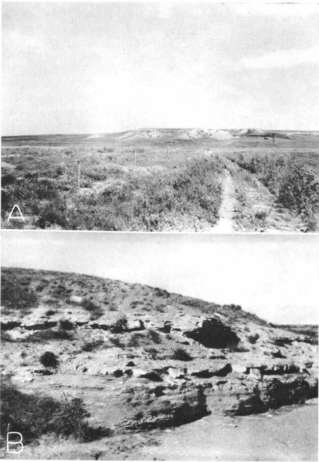
Plate 13--A, Old sink hole in sec. 25, T. 25 S., R. 43 W., Hamilton County; B, Outcrop of volcanic ash in sec. 13, T. 26 S., R. 41 W., Hamilton County; C, Upper beds of the Fort Hays limestone member of the Niobrara formation in sec. 3, T. 22 S., R. 43 W. (Photographs by N.W. Bass.)
Smoky Hill chalk member--The Smoky Hill chalk member was named by Cragin (1896, p. 51) from Smoky Hill river in northwestern Kansas. The thickness of the Smoky Hill chalk member in the Hamilton-Kearny area is not known for it is exposed in only two localities (sec. 3, T. 22 S., R. 43 W. and sec. 14, T. 22 S., R. 42 W.). The beds are comprised principally of chalk and chalky shale with many limonitic concretions and numerous shells of Inoceramus grandis and Ostrea congesta. Although some of the beds appear to be massive, they can be broken easily into thin plates (pl. 11). The lateral gradation prevents the correlation of single beds from one locality to another. A section of the Smoky Hill chalk member measured in sec. 3, T. 22 S., R. 43 W. follows:
| Section of Smoky Hill chalk member of the Niobrara formation in sec. 3, T. 22 S., R. 43 W. | Feet | Inches | |
|---|---|---|---|
| 9. | Chalk, compact, cream-colored; weathers to buff, irregular, pitted surfaces | 3 | 1 |
| 8. | Chalk, fissile, soft, buff | 2 | 8 |
| 7. | Chalk, buff | 2 | |
| 6. | Chalk, fissile, gray | 3 | |
| 5. | Chalk, hard, cream-colored | 10 | |
| 4. | Shale, chalky, fissile, gray | 8 | |
| 3. | Chalk, hard, fossiliferous; contains flat circular limonitic concretions | 5 | |
| 2. | Chalk, platy | 5 | |
| 1. | Shale, chalky, fissile, gray | 3 | 1 |
| Base not exposed | |||
| Total | 11 | 7 | |
The chalk beds of the Smoky Hill member probably underlie the northernmost part of the Hamilton-Kearny area. They are relatively impermeable and yield little or no water to wells in this area.
Tertiary System
Pliocene Series
The silts, sands, and gravels that overlie the Cretaceous bedrock and that underlie the loess, dune sand, and alluvium are of Tertiary and Quaternary age. Because of the lithologic similarity of the Ogallala formation and the undifferentiated Pleistocene deposits in this area it was necessary to map them as a single unit in Hamilton and Kearny counties (pl. 1). Although the contact of the two deposits could not be accurately traced in the field, there is sufficient lithologic and fossil evidence to indicate the general distribution and thickness of each of these deposits. For that reason they are discussed separately in the text.
Several test holes (7, 8, 9, 13, and 15) in the northern part of Kearny County encountered relatively thin deposits of bentonitic clay above the Cretaceous bedrock floor. The clay generally is blocky and is tan, brown, or green. The thickness of these beds encountered in test holes ranges from 2.5 feet to 28.5 feet. The deposits display a marked contrast in lithology to the overlying part of the Ogallala formation in that they are made up almost entirely of clay. Other than the Woodhouse zone the Ogallala formation in this area contains very little clay, and that generally is silty or sandy.
Similar deposits were observed by Elias (1931, pp. 155-158) in Wallace County, Kansas, where they were described as a local phase of the basal Ogallala and named the "Woodhouse clays." In Wallace County they consist of pale-green, reddish-brown, and chocolate-brown bentonitic clays. Because they are relatively impermeable, they yield little or no water to wells in the Hamilton-Kearny area.
Ogallala Formation
Character--The Ogallala formation consists principally of silt, sand, gravel, and some clay. It may be loosely consolidated or tightly cemented by calcium carbonate to form a very compact "mortar bed" that resembles concrete. The material comprising the Ogallala formation is poorly sorted. Individual beds generally are discontinuous and within very short distances may grade laterally or vertically into material of different composition. For this reason it is often necessary to drill several test holes in these beds in order to determine the most suitable location for an irrigation well. Wells that are only a short distance apart may encounter almost totally unlike sequences of sediments above the Cretaceous bedrock floor.
The predominant material in the Ogallala is silt, which constitutes as much as 80 percent of the formation in some localities. The silt is composed almost entirely of irregular and subangular grains of quartz and generally is admixed with fine sand. The sand in the Ogallala is predominantly fine-grained, but in most places where it is associated with gravel it is medium to coarse. Gravel constitutes a relatively small part of the Ogallala formation and generally is found near the base. It is composed principally of feldspar, quartz, and other material derived from igneous rocks but also contains reworked Cretaceous rocks such as sandstone from the Dakota formation. Clay is not abundant in the Ogallala in Hamilton and Kearny counties and where present generally is found near the top of the formation.
Distribution and thickness--Most of the Hamilton-Kearny area is underlain by the Ogallala formation and the undifferentiated Pleistocene deposits (pl. 1). In much of this area, however, these deposits are covered by a thin mantle of loess and dune sand. The Ogallala formation probably crops out in much of the Syracuse upland area and possibly at a few other places where the Cretaceous rocks are exposed. In southern Hamilton County there are several exposures of volcanic ash that Landes (1928, pp. 23-25) and Bass (1926, p. 60) believed to be of Pleistocene age. The ash lies a few feet above the Dakota formation, indicating that the Ogallala is probably very thin or absent in at least a part of the Syracuse upland. In northwestern Hamilton County, the gravels that overlie the Cretaceous beds appear to be of Pleistocene age although no fossils were found that could be used to definitely determine their age. Ogallala deposits probably underlie undifferentiated Pleistocene deposits in most of the Hamilton-Kearny area.
The thickness of the Pliocene and Pleistocene silts, sands, and gravels that overlie the Cretaceous bedrock is extremely variable. Test hole 18 (log 18) encountered only 18.5 feet of such material in the Syracuse upland. In the Stanton area the thickness encountered by test holes ranged from 226 to 254 feet (logs 25 and 26); in the Kearny upland the combined thickness ranges from 56 feet in test hole 5 (log 5) in northwestern Hamilton County to 288 feet in test hole 13 (log 13) in west central Kearny County. In the Kearny County part of the Scott-Finney basin these deposits are more than 380 feet thick (log 43). The greatest thickness of these deposits is in the sand-hills area in southeastern Kearny County where it exceeds 400 feet (logs 19 and 20).
The thickness of the Ogallala formation alone is also quite variable. It is probably absent or very thin in southern and northwestern Hamilton County. In the Syracuse upland the Ogallala formation ranges in thickness from a few feet in western Hamilton County to about 75 feet in southeastern Hamilton County. Much of the unconsolidated silts, sands, and gravels overlying the Cretaceous bedrock in northeastern Hamilton County and northern Kearny County belong to the Ogallala formation. The thickness of Ogallala deposits encountered by test holes in that area ranged from about 10 to about 180 feet. In the Stanton area in southwestern Hamilton County and in the sand-hills area in southeastern Kearny County, only a small part of the post-Cretaceous deposits are of Ogallala age. The formation is very thin or absent in the Stanton area and is about 60 feet thick in southeastern Kearny County.
Origin--The silt, sand, and gravel of the Ogallala formation and of the undifferentiated Pleistocene deposits were carried in from the Rocky Mountains by shifting streams. This would explain the rapid gradations in lithology both vertically and laterally. Smith (1940, pp. 85, 86), in his discussion of the origin of the Ogallala formation, states that:
The deposition of the Ogallala formation began with the change from stream degradation to aggradation. Just where this reversal first took place along the stream courses is uncertain, but it may plausibly be inferred that the locus of initial deposition corresponds approximately with the zone of maximum thickness in the formation, and thus falls within western Kansas. During the early stages of deposition, there was a topography of moderate relief. The main valleys were occupied by through-going streams from the Rocky Mountains, and the valley bottoms were mantled by normal flood-plain deposits. Some local material was probably carried in by side streams, and locally, as in Clark County, there was creep of sizable blocks of rock down the valley sides. In the southern part of the area, there may have been streams heading in the Sierra Grande arch. Deposition probably began with the filling of stream channels, leading to more frequent overflow and thus to the upbuilding of the floodplains. This soon led to shifting of the channels themselves, and probably to the development of anastomosing patterns. As filling progressed, the valley flat overlapped farther and farther on the slopes of the bordering hills, and the zone of deposition encroached farther and farther east and west. Relief was lowered, the valley plains grew broader, and finally the divides were overtopped, and there followed overlapping and coalescing of the depositional zones of individual streams. As depositional areas grew broader the rate of upbuilding must have declined, allowing greater time for the work of soil processes on the successive accretions of sediment. Undoubtedly the trunk streams deployed into branching distributaries, and these shifted sluggishly across broad and overlapping triangular areas. The bedrock divides were buried deeper and deeper, and one vast, continuous alluvial plain came to extend from the slopes of the Rockies perhaps as far as the Flint Hills in Kansas. Probably the waters of the depositing streams were gradually dissipated as they neared the border of this plain, so that none escaped beyond. Eastward and westward the margins of the alluvial mantle thinned out against the older rocks, and at the south the Sierra Grande highland probably rose gradually above the depositional surface. Over a great area, only one monadnock rose sharply above the alluvial plain--"Two Buttes," in southeastern Colorado, held up by an igneous intrusion and surrounding altered sediments.
Age and correlation--The Ogallala formation is probably equivalent in age to the Ogallala in other parts of Kansas and Oklahoma. Fossils taken from these beds in other areas indicate that they are of middle Pliocene age. Schoff (1939, p. 61) reports that more than 10,000 middle Pliocene horse teeth have been taken from excavations in these beds at a point near Optima in Texas County, Oklahoma.
Water supply--Most of the wells in northeastern Hamilton County and in northern Kearny County obtain their water from the Ogallala formation. In the Kearny-County part of the Scott-Finney basin deep irrigation wells obtain water from both the Ogallala formation and the overlying Pleistocene deposits. In other parts of the Hamilton-Kearny area the Ogallala formation yields little or no water to wells. In the Syracuse upland these beds lie above the water table so that wells must be drilled to the Dakota formation in order to obtain water. In the Arkansas valley, in the sandhills area, and in the Stanton area wells can obtain supplies of water adequate for most uses from the Quaternary deposits so that only a few wells in those areas penetrate the underlying Ogallala beds. The yields of wells in the Ogallala formation range from a few gallons a minute from many domestic and stock wells to more than 1,000 gallons a minute from some irrigation wells in the Kearny County part of the Scott-Finney basin. The largest yields from the Ogallala can be obtained from the coarse sands and gravels that are most abundant in the lower part of the formation.
Water from the Ogallala formation is relatively hard, but it is suitable for most ordinary uses. Because of its relatively high fluoride content it may be harmful to children's teeth.
Quaternary System
Pleistocene Series
Undifferentiated Deposits
Character--The undifferentiated Pleistocene deposits consist principally of unconsolidated sand, gravel, and silt, containing local deposits of volcanic ash. Sand generally is the most abundant material and gravel and silt occur in lesser amounts but locally may be the predominant constituents. Test hole 20 (log 20), for example, penetrated 315 feet of these deposits of which about 50 percent was gravel and 40 percent was sand. The silt is made up almost entirely of angular to subangular quartz grains as is the fine and medium sand. The coarse sand and the gravel are composed of quartz, feldspar, and other material derived from igneous rocks.
The Pleistocene deposits are poorly sorted. Individual beds generally are discontinuous and within very short distances may grade vertically or laterally into material of different composition. For that reason, most beds along the outcrops of these deposits can be traced for only short distances. Beds of gravel generally contain many lenses of silt and sand as well as clay in the form of rounded "clay balls" that range in diameter from a few inches to nearly 2 feet. These deposits generally are unconsolidated. Some beds, however, are cemented by calcium carbonate to form hard "mortar beds" resembling concrete.
The undifferentiated Pleistocene deposits include the terrace deposits of the Arkansas river valley (pl. 17), which are composed mainly of gravel containing intermixed silt, sand, and clay. The sand and gravel is made up principally of material derived from igneous rocks. The gravels in the 30-foot terrace northwest of Medway, however, contain many flat tabular platy and subangular fragments of limestone that probably were derived from near-by outcrops of Cretaceous rocks. Terrace deposits extend many miles south of the Arkansas valley, but their southern limit was not mapped because of their similarity to other Pleistocene deposits and because of the mantle of dune sand that, covers much of that area.
Plate 17--A, Quarry in terrace gravels in sec. 18, T. 25 S., R. 36 W., Kearny County; B, Terrace gravels in sec. 27, T. 23 S., R. 42 W., Hamilton County.
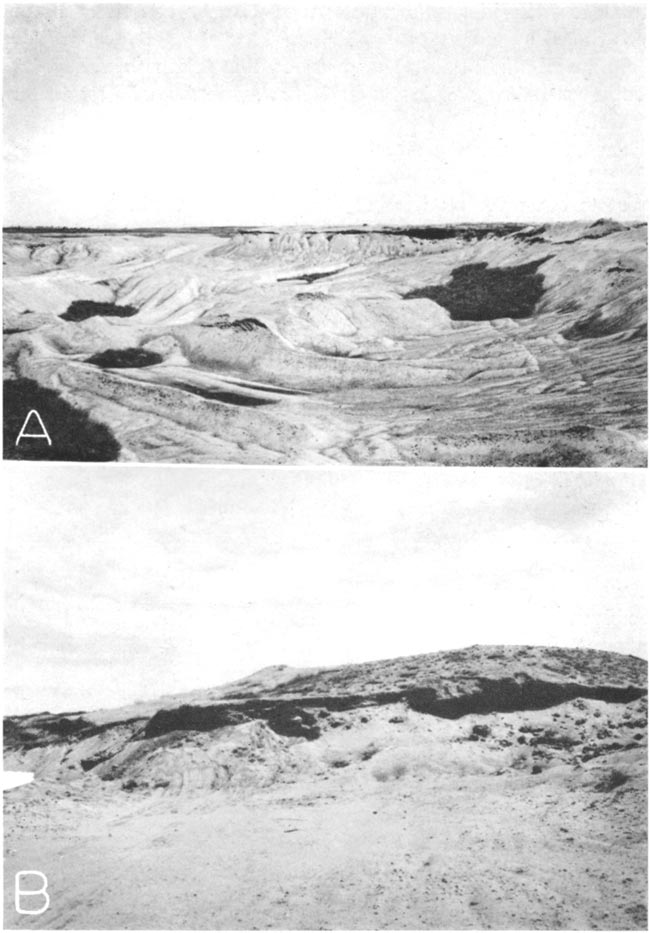
Thin beds of volcanic ash crop out in southern Hamilton County along Little Bear creek and its tributaries (Bass, 1926, p. 60; Landes, 1928, p. 25). The largest of these is along a small stream bed in the northern half of sec. 13, T. 26 S., R. 41 W., where it is 2.5 feet thick (pl. 13). It is a compact white ash underlain by several feet of buff to tan clay and overlain by several feet of unconsolidated sand and gravel. Samples collected from this outcrop were analyzed by Landes (1928, p. 25) who found that 39 percent of the ash passed through a 20-mesh screen and was retained on a 100-mesh screen. This was the coarsest of 37 samples of Kansas ash analyzed by Landes.
Because of its color and associations, the ash was believed by Landes to be of Pleistocene age. It differs from most Pleistocene ash deposits, however, in that it is more compact and breaks off into slabby layers. The presence of a bed of clay beneath the ash also implies that it is equivalent in age to the Pleistocene ash of Grant, Haskell, and Meade counties.
As suggested by Landes (1928, p. 19), the original source of the ash must have been volcanic vents in the southwest--perhaps the Capulin group of volcanoes in northeastern New Mexico. The ash was showered over a large area, but subsequent erosion carried part of it away and part was concentrated in small areas.
Distribution and thickness--The undifferentiated Pleistocene deposits crop out in a large part of Hamilton and Kearny counties (pl. 1). They crop out in all of the Kearny County part of the Scott-Finney basin and they underlie almost all of the Kearny upland and the Stanton area, where they are in most places covered by a thin mantle of loess. They also underlie most of the sand-hills area, where they are covered by a relatively thin deposit of dune sand.
The undifferentiated Pleistocene deposits range in thickness from a few feet in northwestern Hamilton County to more than 300 feet in southeastern Kearny County. In the Stanton area they generally are about 200 feet thick, and in the Kearny upland they are 25 to about 250 feet thick. The greatest thickness of these beds is in the sand-hills area in southeastern Kearny County where they average more than 200 feet.
Origin--The undifferentiated Pleistocene deposits probably were laid down in a manner similar to that in which the beds of the Ogallala formation were deposited (p. 139).
Age and correlation--Fossils collected from these beds in this and adjacent areas indicate that they are of Pleistocene age. A fossil tooth taken from a gravel pit a few miles south of the Kearny-Grant county line was identified by Claude W. Hibbard of the University of Kansas Museum of Vertebrate Paleontology as Equus niobrarensis Hay, indicating that those beds probably are equivalent in age to the Meade formation in Meade County, Kansas (Frye and Hibbard, 1941, p. 411). The undifferentiated Pleistocene beds in Hamilton and Kearny counties probably are in part equivalent in age to the Pleistocene gravels in Scott, Finney, Gray, Grant, Haskell, and Seward counties, Kansas. Some of these deposits may be in part equivalent to the lower part of the Kingsdown silt of Ford, Meade, and Clark counties.
Water supply--Almost all of the wells in the sand-hills area, in the Stanton area, and in the Kearny County part of the Scott-Finney basin obtain part or all of their water from the undifferentiated Pleistocene deposits at depths ranging from 20 feet to more than 100 feet. The yields of the wells range from a few gallons a minute from most domestic and stock wells to more than 1,000 gallons a minute from some irrigation wells in the Scott-Finney basin north of Lakin and Deerfield. Large yields are also obtained from a few wells in the Arkansas valley that penetrate both the alluvium and the underlying Pleistocene deposits.
The undifferentiated Pleistocene deposits, together with the beds of the Ogallala formation, serve as a huge underground reservoir. The reservoir may at one time have been nearly full, but streams such as Arkansas river have cut down into the reservoir and have drained part of the water from it. Drillers speak of the water in these beds as occurring in "sheets" separated by zones that yield little or no water. Some drillers have reported as many as eight such "sheets" within these deposits. It is probable that these are not separate zones of saturated material, but simply one saturated zone containing alternating beds of fine and coarse material. The fine material, although saturated, probably does not yield enough water for domestic or stock use so the drillers regard it as dry. The coarse material yields water freely and is logged as "water sand."
Water from the undifferentiated Pleistocene beds is relatively hard, particularly in the Scott-Finney basin north of Deerfield. The softest water obtained from these beds is found in the sand-hills area south of the Arkansas river. The fluoride content is relatively high in the Scott-Finney basin and is relatively low in the sandhills area.
Pleistocene and Recent Series
Loess
General features--A thin deposit of loess overlies the Ogallala formation and undifferentiated Pleistocene deposits in much of Hamilton and Kearny counties. It occurs principally on the Kearny upland in northeastern Hamilton County and northern Kearny County and on the Syracuse upland in southern Hamilton County. The loess generally is buff to brown but may be dark brown to black in the soil zone. The material is structureless and may contain scattered limy concretionary nodules. It is composed principally of silt but contains some very fine sand. Mechanical analyses (table 19) made by Smith (1940, p. 122) indicate maxima in the 0.062-0.031 mm division for most of the samples studied. Fractions larger than 0.062 mm were separated by screening; those smaller than 0.062 were separated by the pipette method.
Table 19--Mechanical analyses of loess and associated materials. Modified from Smith (1940, p. 122). The maxima are shown in italics.
| No. of sample |
Location | Mechanical composition | |||||
|---|---|---|---|---|---|---|---|
| 0.5 mm. |
0.5- 0.25 |
0.25- 0.125 |
0.125- 0.062 |
0.062- 0.031 |
0.032 | ||
| 1 | SW sec. 26, T. 21 S., R. 41 W. | 0. 03 | 1.0 | 6.5 | 49.4 | 34.5 | 8.7 |
| 2 | SW sec. 31, T. 22 S., R. 40 W. | 1. 8 | 0.9 | 6.8 | 27.9 | 47.0 | 15.7 |
| 3 | W2 sec. 19, T. 23 S., R. 40 W. | 0.0 | 0.03 | 2.2 | 32.6 | 49.5 | 15.6 |
| 4 | SW sec. 18, T. 25 S., R. 40 W. | 0.8 | 1.4 | 3.2 | 3.7 | 45.7 | 45.7 |
| 5 | NW sec. 33, T. 25 S., R. 42 W. | 0.02 | 0.2 | 2.0 | 20.2 | 41.5 | 36.1 |
| 10 | SW sec. 3, T. 22 S., R. 36 W. | 0.03 | 0.1 | 9.0 | 13.6 | 57.1 | 20.1 |
The soils formed from the loess are dark compact heavy silt loams, clay loams, and silty clay loams underlain by a lighter-colored calcareous clay subsoil. Because of the incoherent character of the loess, natural exposures are few and the complete thickness of the deposits cannot readily be determined. Thicknesses in excess of 10 feet were observed north of Arkansas river between Lakin and Hartland and along the north side of the Syracuse upland southwest of Syracuse. Most of the test holes in the Hamilton-Kearny area encountered deposits of loess that ranged in thickness from 1 to 8 feet. These deposits probably are equivalent to the Kingsdown silt of southwestern Kansas.
Water supply--No water is obtained from the loess because it lies above the zone of saturation. Because the loess has low permeability, it retards the downward movement of rain water and thus hinders the recharge of the ground-water reservoir.
Dune Sand
Character--A thin mantle of dune sand covers a large area south of Arkansas river in Hamilton and Kearny counties (pl. 1). The material consists of uniform medium-grained well-rounded quartz sand. Where soil zones have developed on the dune sand, it contains small amounts of clay and organic material.
Distribution and thickness--The dune sand covers a large area on the south side of Arkansas river from western Hamilton County to eastern Kearny County. Between Coolidge and Hartland the sand-hills area ranges in width from 3 to 7 miles. All of southeastern Kearny County that lies south of Arkansas river and east of Bear creek is covered by dune sand. This belt of sand dunes extends westward into Prowers County, Colorado, and eastward to Reno County.
The thickness of dune sand encountered by test holes ranges from 5 feet (log 16) to about 34 feet (log 19). The test holes, however, were drilled between sand hills and therefore did not penetrate the maximum thickness of dune sand. It is probable that in some of the high dunes the thickness is 75 feet.
Origin-The dune sand probably was derived from sands of the alluvium of Arkansas river valley and from the terrace deposits that extend many miles south of the valley. The broad flat plain formed by the terrace deposits constitutes an excellent area for dune development.
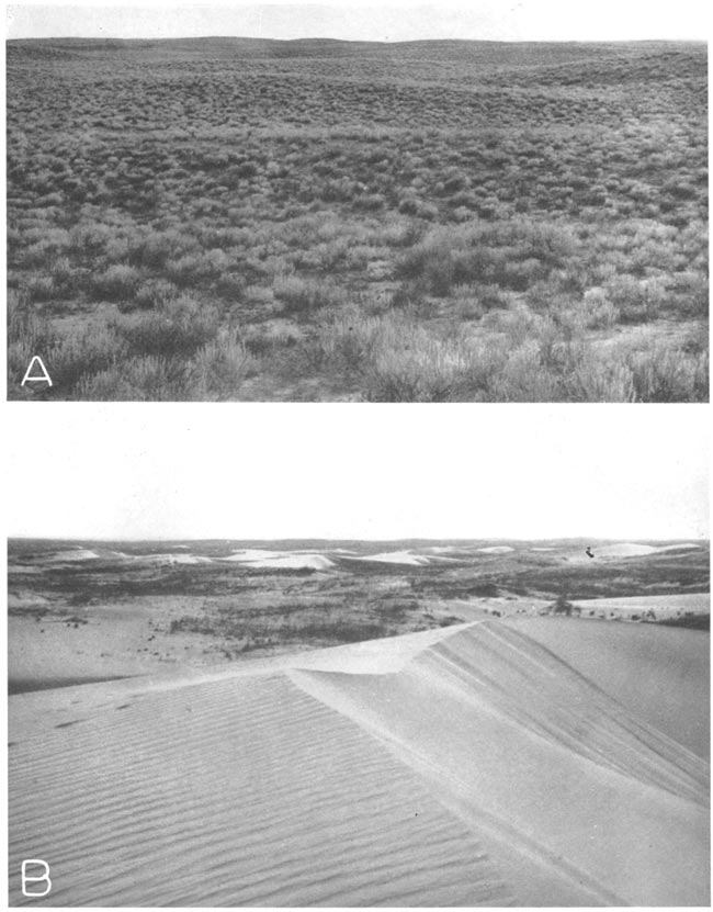
In his discussion of the origin of sand dunes in western Kansas, Smith (1940, p. 160) describes an ideal dune cycle consisting of two phases: First, an eolian, or active phase, during which the dune is built up; second, an eluvial, or passive phase, during which vegetation prevents further growth and the dune is subdued by weathering and creep. He divides the eluvial phase into stages of youth, maturity, and old age. In the youth stage the soil zone is formed and the slopes are somewhat reduced. The dune becomes mature when its profile is smooth and regular and when its soil becomes thicker and more stable. Old age is reached when the dune form is undistinguishable. He states that the eluvial phase in any stage may be interrupted by rejuvenation.
Both the eluvial and eolian phases are represented in the sand hills in Hamilton and Kearny counties, but most of the dunes are in the eluvial phase at the present time. Most of the dunes are in the youthful stage of the eluvial phase in this area (pl. 16) for their slopes are moderate and a thin soil zone has developed. At several places in this area, however, the dunes are in the eolian phase (pl. 15). Recent droughts accompanied by strong winds have caused the rejuvenation of many sand dunes (pl. 14). Blowouts have formed around water wells where the livestock have trampled the grass and in fields where cultivation has been attempted.
Plate 14--A, Sink hole 11 miles south of Coolidge at SE sec. 15, T. 25 S., R. 42 W.; B, Sand drifts invading field in sec. 22, T. 25 S., R. 38 W., Kearny County; C, Dune ridge of recent origin in blowout 9 miles southeast of Kendall, Kearny County. (Photographs by H.T.U. Smith.)
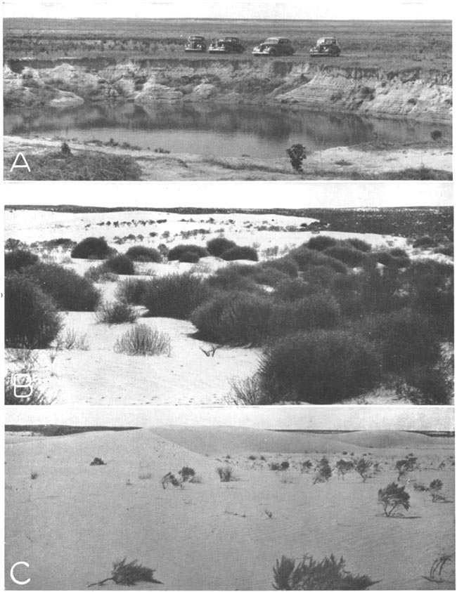
Plate 15--Aerial photograph of dune ridges southwest of Syracuse. Scale: 3 inches = 1 mile. (Photograph from the U.S. Soil Conservation Service, August 1936.)
Plate 16--A, Grass-covered sand hills southeast of Deerfield; B, Active sand dunes about 4 miles southwest of Syracuse. (Photographs by H.T.U. Smith.)
Age--The dune sand probably was deposited after the formation of the loess. Smith (1940, p. 128) found loess beneath the dune sand in Finney and Meade counties; however, test holes drilled in the sand hills in Hamilton and Kearny counties failed to encounter loess beneath the dune sand. The formation of the dunes probably began in Pleistocene time and continued into Recent time. Fossil snails taken from beds underlying the dune sand in northern Haskell County were identified by A. B. Leonard of the Department of Zoology, University of Kansas, who recognized 14 species and stated that the beds were Pleistocene and probably equivalent to the "Jones Ranch beds" of the Meade formation in Made County, Kansas (Frye and Hibbard, 1941, p. 415).
Water supply--The dune sand lies above the water table so it does not supply water to wells; however, the porous sand dunes provide excellent recharge facilities for the underlying ground-water reservoir.
Alluvium
Alluvium is found in the valleys of Arkansas river and its tributaries, but only in the Arkansas river valley is it of sufficient importance to discuss in this report. The following discussion, therefore, deals only with the alluvium of Arkansas river.
General features--The alluvium comprises sand and gravel and lesser amounts of silt and clay. The material is poorly sorted and grades into material of different composition within a few feet both laterally and vertically. The sand and gravel are made up of rounded and subrounded grains of quartz, feldspar, and other material derived from igneous rocks. The sand, gravel, and silt may be found in any part of the formation but the clay generally is found at or near the base
The alluvium is underlain by the Graneros shale and the Dakota formation between Coolidge and Hartland and by undifferentiated Pliocene and Pleistocene deposits between Hartland and Deerfield. In the area between Hartland and Deerfield the bed of clay that is encountered at depths of 35 to 45 feet represents the base of the alluvium. Below the bed of clay, the character of the material as well as the quality of the water is quite different from that of the alluvium.
The thickness of the alluvium ranges from about 10 feet southwest of Hartland to about 100 feet south of the river near Coolidge. Generally, however, the thickness in Hamilton County is between 50 and 60 feet and in Kearny County it is between 40 and 50 feet.
Most of the material comprising the alluvium was derived from the Rocky Mountains. Part was brought directly from the mountains and part is reworked material from the Tertiary and Pleistocene deposits which in turn were derived principally from the Rocky Mountains. A relatively small amount of the alluvium was derived from nearby Cretaceous rocks.
Water supply--As indicated by the pumping tests (pp. 88-90), the alluvium is relatively permeable and yields large quantities of water to wells in both Hamilton and Kearny counties. Properly constructed wells may obtain 1,000 gallons of water a minute from the alluvium in almost any part of the Arkansas valley. The depths to water level in the alluvium range from 5 feet to about 20 feet.
The water from the alluvium is hard and has a relatively large content of sulphate and fluoride. The fluoride content is sufficiently great to cause the mottling of some children's teeth. South of the river in western Hamilton County, recharge of the alluvium from rainfall in the nearby sand hills has caused water in the alluvium to be relatively soft.
Prev Page--Utilization, Quality || Next Page--Well Records, Hamilton
Kansas Geological Survey, Geology
Placed on web Oct. 25, 2007; originally published December 1943.
Comments to webadmin@kgs.ku.edu
The URL for this page is http://www.kgs.ku.edu/General/Geology/Hamilton/06_form.html