![]()
Prev Page--Introduction || Next Page--Geology
Geography
Topography and Drainage
Hamilton and Kearny counties are in the High Plains section of the Great Plains physiographic province. The area comprises seven physiographic divisions (fig. 2), most of which were defined by Smith (1940, pp. 140-146). These areas are described in the following pages.
Figure 2--Map of Hamilton and Kearny counties showing location of test holes, lines along which cross sections are drawn (figs 7 and 8), and physiographic divisions. A represents the Kearny upland; B, the Scott-Finney basin; C, the Arkansas river valley; D, the sand-hills area; E, the Syracuse upland; F, the Stanton area; and G, the Bear Creek depression.
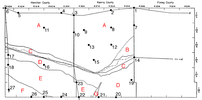
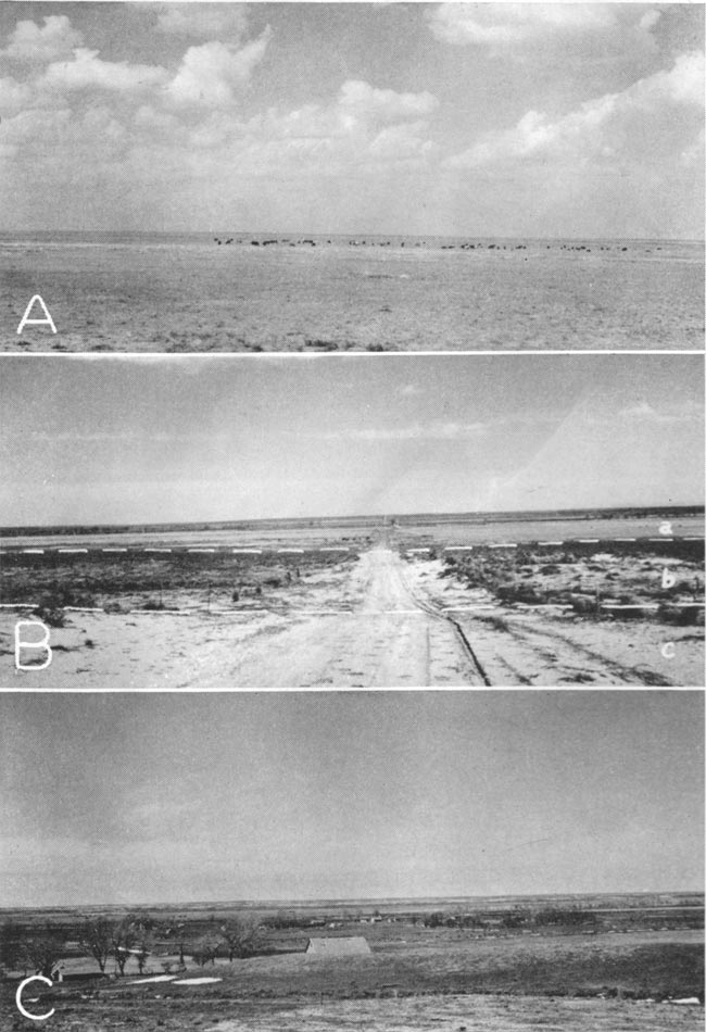
Plate 4--A, View of the upland in northern Kearny County; B, Arkansas valley south of Mayline showing (a) the valley floor, (b) the river terrace, and (c) the edge of the sand dunes; C, Arkansas river valley near Kendall, sand hills in the distance.
Kearny upland. Most of the northern half of the area is a relatively flat featureless plain that slopes toward and merges with the Scott-Finney depression on the east and slopes toward Arkansas river on the south. Several small intermittent streams in the western part of this area flow southward into Arkansas river. In the eastern part of the area are several long intermittent streams that flow east-southeastward and terminate in broad shallow depressions near the western edge of the Scott-Finney basin. The altitude of the area ranges from about 3,850 feet in northwestern Hamilton County to about 3,100 feet in northeastern Kearny County. The average eastward slope is about 14.5 feet to the mile.
Scott-Finney basin. A small part of the Scott-Finney basin extends into Kearny County (fig. 2). This basin merges gradually into the upland area, and no sharp dividing line can be drawn between them. The basin slopes gently toward the Arkansas valley and is separated from it by a low bluff.
Arkansas river valley. Arkansas river rises in the mountains of west central Colorado and, upon leaving the mountains near Canon City, flows eastward across the high plains of eastern Colorado, entering Hamilton County at a point near Coolidge. From that point it flows east-southeastward to Hartland in Kearny County where it swings abruptly toward the northeast and leaves the area at a point near Deerfield. The valley ranges in width from 2 to 3 miles in Hamilton County but is less than 1 mile wide at its narrowest point near Hartland. East of Hartland the valley broadens and attains a maximum width of nearly 4 miles in the eastern part of Kearny County. Bordering the valley on the north is an almost continuous line of bluffs which have a maximum height of nearly 150 feet near Hartland. East of Lakin the bluffs diminish in height and near Deerfield they are hardly discernible. On the south, the river valley is bordered by sand hills which rise only a few feet above the river terrace.
Sand-dune area. The sand-dune area is adjacent, to the Arkansas valley and comprises a narrow belt that is 3 to 5 miles wide in Hamilton County but broadens greatly in eastern Kearny County where its maximum width is more than 16 miles. In several places, particularly west of Syracuse, the dunes have encroached upon Arkansas river until they are only a few yards from the river channel.
The dune area comprises irregular, grass-covered, undrained basins. In eastern Kearny County and in some parts of Hamilton County the dune-sand area is a relatively flat, grass covered plain with broad low mounds and wide shallow depressions, and is bordered on the north and on the south by an east-west band of higher, more rugged, and generally more barren dunes. The altitude of the sand-dune area is only a few tens of feet higher than the Arkansas valley and is more than 150 feet lower than the upland area that lies north of the valley. The maximum relief in the sand-hills area is about 70 feet and is near the river west of Syracuse. The area of minimum relief is in southeastern Kearny County.
Syracuse upland. This is the name given by Smith (1940) to the long tableland that extends from western Hamilton County to southwestern Kearny County. It is bordered on all sides by steep slopes, but the central part of the area is relatively flat. The Syracuse upland attains a maximum altitude of 3,680 feet in western Hamilton County, which is higher than any other point in the area except the northwestern part of the Kearny upland. The surface of the upland slopes east-southeastward at the rate of 10 to 30 feet to the mile.
Stanton area. The southwestern corner of Hamilton County is a part of the Stanton area as defined by Smith (1940). It is a relatively flat plain that slopes eastward at the rate of about 18 feet to the mile. It is bordered on the north by the bluffs that form the southern edge of the Syracuse upland. The area is drained by Little Bear creek, an intermittent stream that flows southeastward adjacent to the bluffs of the Syracuse upland.
Bear Creek depression. Bear creek originates in westernmost Baca County, Colorado, at a point nearly 60 miles west of the state line. From the point in southwestern Stanton County where it enters Kansas, Bear creek flows northeastward to the northeastern part of Stanton county where, at its point of confluence with Little Bear creek, it flows eastward into Grant County. The stream then turns north and terminates in the sand hills southwest, of Lakin. Its valley in Kearny County is a long narrow depression that trends north-northeast.
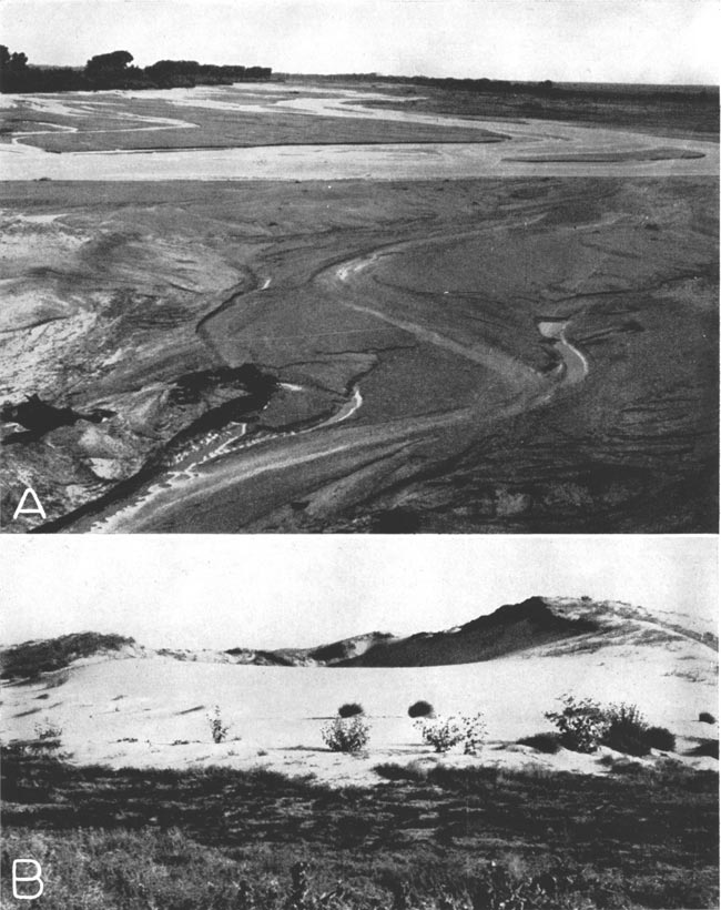
Plate 5--A, Channel of Arkansas river at Kendall; B, Blowout in the sand dunes south of Syracuse, view looking south (photographs by H.T.U. Smith).
Climate
The climate in Hamilton and Kearny counties, as in other parts of the High Plains section, is characterized by low precipitation, rapid evaporation, and a wide range of temperature variations. The summer days generally are hot, but the wind movement and the usually low humidity cause the nights to, be relatively cool. The winters are moderately cold, but generally are free from excessive snowfall and damp cloudy days.
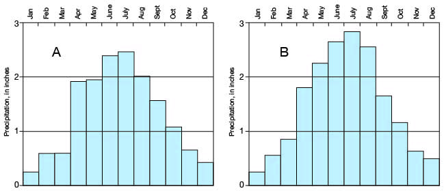
The precipitation in the Hamilton-Kearny area usually is local and sporadic and the amount of rainfall in one storm may vary greatly from one part of the area to another. The greatest annual precipitation on record in this area was 29.50 inches at Syracuse in 1923. (All climatic data, unless otherwise stated, are based on the records of the U. S. Weather Bureau's stations at Syracuse and Lakin.) The second greatest precipitation was 27.99 inches recorded at Lakin in 1941. The mean annual precipitation at Syracuse is 17.67 inches (fig. 3) and at Lakin it is 15.85 inches (fig. 4). The greatest precipitation is during the summer months, particularly in July, and the least precipitation is during December and January (fig. 5).
Figure 3--Graphs showing (A) the annual precipitation at Syracuse, Kansas, and (B) the cumulative departure from normal precipitation at Syracuse (from records of the U. S. Weather Bureau).
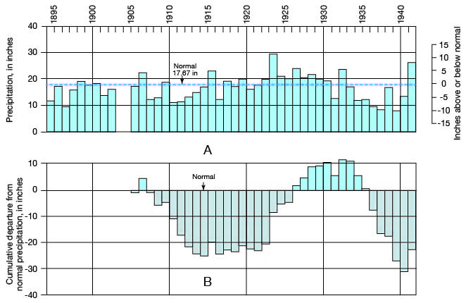
Figure 4--Graphs showing (A) the annual precipitation at Lakin, Kansas, and (B) the cumulative departure from normal precipitation at Lakin (from records of the U. S. Weather Bureau).
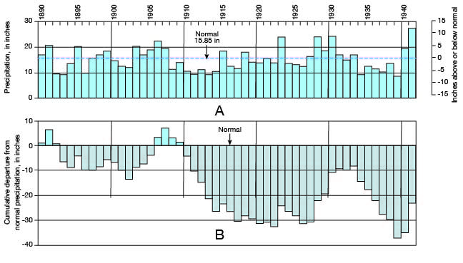
Figure 5--Graphs showing (A) the average monthly distribution of precipitation at Lakin, and (B) the average monthly distribution of precipitation at Syracuse (from records of the U. S. Weather Bureau).
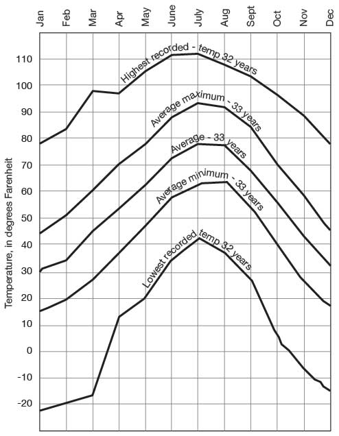
The mean annual temperature in this area is 53.9° F. The highest, temperature ever recorded was 115° F., in July, and the lowest was -26° F., in January. The average date of the last killing frost in the spring is April 27, but there have been killing frosts as late as May 27. The first killing frost in the fall has occurred as early as September 17, but its average date is October 14. The average length of the growing season is 169 days at. Syracuse and 171 days at Lakin. The monthly temperature ranges at Lakin are shown in figure 6.
Figure 6--Graph showing the monthly temperature ranges at Lakin. Modified from Smith (1940, p. 27).
The winds are strong throughout the year, especially in late winter and early summer, the prevailing winds being from the south and southwest. Generally more than 300 days of each year are clear or only partly cloudy; this high proportion of clear days, together with the high summer temperatures, low relative humidity, and high wind velocity, results in a total yearly evaporation of about 60 to 70 inches from a free water surface.
Mineral Resources
[Note: more current information is available online on the oil and gas resources of Hamilton and Kearny counties.]
Ten gas wells having open flows of 9,690,.000 to 21,600,000 cubic feet a day have been drilled in the sand-hills area in southeastern Kearny County in recent years. These wells, and a few gas wells in southwestern Finney County, once constituted the Holcomb gas field but they are now considered a part of the Hugoton gas field. They obtain gas from the Wreford limestone or the Florence limestone of the Wolfcampian group of the Permian series at depths ranging from 2,670 to 2,850 feet. The gas is carried by pipe line to Lakin, Deerfield, Holcomb, Scott City, and cities in southern Nebraska.
Several unsuccessful oil-test wells were drilled in the Hamilton-Kearny area before oil was finally discovered in 1941. In 1925 the Wood Oil Company No. 1 Ranson well, NW sec. 5, T. 26 S., R. 41 W., southwestern Hamilton County, was drilled to the limestones of Mississippian age at a depth of 5,488 feet but failed to find either oil or gas. The well at that time was the deepest in Kansas. A few years later a test well on the Porter farm, in the NE sec. 30, T. 25 S., R. 41 W., was drilled to a depth of 6,453 feet but failed to find oil or gas. A detailed seismographic survey of the Syracuse anticline in southwestern Hamilton County was begun by Stanolind Oil and Gas Company in the spring of 1942, so the possibilities for commercial production of oil and gas in this area probably will be tested by drilling in the near future.
On May 12, 1940, Stanolind Oil and Gas Company began a deep test on the J. M. Judd farm, SE cor. sec. 15, T. 21 S., R. 3S W., in northwestern Kearny County. This well was drilled into pre-Cambrian rocks to a total depth of 6,071 feet. Shows of oil were found in the Kansas City-Lansing limestones and in the Mississippian limestones but none was adequate for commercial production. After drilling another unsuccessful test near the Judd well, Stanolind Oil and Gas Company, in August, 1941, completed the No. 1 G. O. Patterson well in the SE sec. 23, T. 22 S., R. 38 W., at a total depth of 5,690 feet. The well had an initial production of 3,964 barrels a day from a sand zone encountered at 4,740 feet in the Cherokee shale of Pennsylvanian age. Subsequently the Stanolind Oil and Gas Company No. 1 Gropp, an offset to the Patterson well, was drilled to the same producing horizon and obtained an initial production of more than 3,500 barrels a day.
Sand and gravel and building stone are other natural resources of this area. Sand and gravel are used for road material in both Hamilton and Kearny counties, and are taken from the alluvium of the Arkansas valley, from Arkansas river terraces, and from the Pleistocene deposits on the upland near Syracuse and near Kendall.
Building stone has been quarried from the sandstones of the Dakota formation in secs. 22 and 27, T. 26 S., R. 41 W. and sec. 27, T. 26 S., R.,40 W. Many buildings in Coolidge, Syracuse, and Kendall were built with stone from the Bridge Creek limestone member of the Greenhorn limestone. Most of these quarries are along Bridge creek in the southwestern part of T. 22 S., R. 42 W. A few farm buildings have been constructed of stone quarried from the Fort Hays limestone member of the Niobrara formation in sec. 3, T. 22 S., R. 43 W.
Agriculture
The soils of Hamilton and Kearny counties are predominantly of three types (soil types 1, 2, and 6 of Joel, 1937, pp. 8-14). Soil type 1 is a heavy, compact, dark soil consisting of clay loams and silty clay loams and is especially suited for growing wheat and other small grains. This type of soil is derived from the loess that covers much of the northern half of the Hamilton-Kearny area. Although soil type 1 is rather susceptible to wind erosion, it very thick and is not easily depleted. Soil type 2 is a moderately friable, brown and light-colored soil consisting of silt loams and clay loams overlying a calcareous subsoil. This type of soil is derived from the Pleistocene silts, sands, and gravels and is found in part of the upland north of Arkansas river, in southern Hamilton County, and in southwestern Kearny County. Soil type 6 consists principally of fine sand and is derived from the Quaternary dune sand that is found south of Arkansas river. This type of soil supports only slight plant growth and is very susceptible to wind erosion.
There was a total of 810,692 acres of land under cultivation in Hamilton and Kearny counties in 1940 (all agricultural data, unless otherwise stated, are from records of the U. S. Census Bureau). There were nearly 1,050 farms and the average farm comprised about 970 acres. There were 17,266 acres of land under irrigation, mostly in the Arkansas valley and in the Kearny County part of the Scott-Finney basin. More than 10,000 acres of this land were irrigated by water from wells or by surface water supplemented by supplies of ground water. The following list of crops grown in Hamilton and Kearny counties was compiled by the 1940 census.
Table 1---Acreage of principal crops grown in Hamilton and Kearny counties in 1940.
| Wheat | 73,977 |
| Sorghums | 25,320 |
| Hay (other than alfalfa) | 8,946 |
| Alfalfa | 6,098 |
| Barley | 2,649 |
| Root and grain crops (other than corn and annual legumes) | 1,957 |
| Broom corn | 965 |
| Sugar beets | 963 |
| Corn | 331 |
| Rye | 147 |
Population
During the period of above-normal precipitation between 1920 and 1930 the population of this area increased more than 25 percent to a total of 6,524 inhabitants. The extended drouth in the next decade resulted in a decrease of 20 percent in population leaving about 5,170 people in 1940, or less than three persons to the square mile. Since the area was, first settled, its population has fluctuated in accordance with climatic conditions. Syracuse, the county seat and principal city of Hamilton County, had a population of 1,226 in 1940. Other important cities are Lakin (population 709), county seat, of Kearny County, and Deerfield (population 356), also in Kearny County.
Transportation
The main line of the Atchison, Topeka, and Santa Fe Railway crosses the area along the Arkansas valley and serves the communities of Deerfield, Lakin, Hartland, Kendall, Syracuse, and Coolidge. The principal hard-surfaced road in this area is U. S. Highway 50 which is nearly parallel to the river. Kansas Highway 27 is an oiled road that crosses Hamilton County in a north-south direction through Syracuse. From Syracuse to the Stanton county line this road is also a part of U. S. Highway 270. Kansas Highway 25 crosses Kearny County from north to south through Lakin and is oiled from Lakin to the Grant County line.
In addition, there are several graveled county and township roads in the area. Most of the roads, however, are not surfaced; but because of slight precipitation and rapid evaporation, the earth roads are passable during most of the year. Drifting sand is a hazard to driving in parts of the sand-dune area south of the river.
Prev Page--Introduction || Next Page--Geology
Kansas Geological Survey, Geology
Placed on web Oct. 25, 2007; originally published December 1943.
Comments to webadmin@kgs.ku.edu
The URL for this page is http://www.kgs.ku.edu/General/Geology/Hamilton/03_geog.html