![]()
Back to Irrigation Supplies...
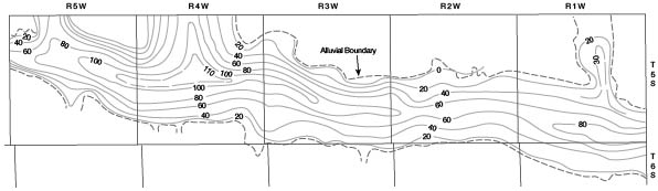
Figure 8
Figure 8--Map showing saturated thickness of Pleistocene deposits in Republican River and Buffalo Creek valleys in Cloud County. A larger version of this figure is available.
Back to Irrigation Supplies...
Kansas Geological Survey, Geology
Placed on web June 29, 2009; originally published May 1959.
Comments to webadmin@kgs.ku.edu
The URL for this page is http://www.kgs.ku.edu/General/Geology/Cloud/fig8.html