![]()
Prev Page--Introduction || Next Page--Geology
Geography
Topography and Drainage
Cloud County lies in the Dissected High Plains section of the Great Plains physiographic province (Schoewe, 1949). The topography represents several types: high flat upland areas resembling the High Plains farther west, gently rolling areas on the Dakota Formation dotted with many mounds or buttes, the broad flat valleys of Solomon and Republican Rivers, and a belt of deeply dissected uplands between the upland and river valleys. Topographically subordinate but important in a ground-water study are the broad flat terraces in the valleys and also the salt marshes in northwestern Cloud County, which affect the quality of water.
The lowest points in Cloud County, about 1,300 feet above sea level, are in the southwestern part of the county along Solomon River and in the northeastern part of the county along Republican River. The highest point is about 1,700 feet, in south-central Cloud County on the divide between Solomon and Republican Rivers.
Approximately two-thirds of Cloud County is drained by Republican River. This stream rises in Colorado and flows generally eastward through Colorado and Nebraska to about the northwest comer of Republic County, Kansas, then bends southeastward to join Smoky Hill River at junction City to form Kansas River. In Cloud County, tributary streams that enter Republican River from the north rise in Republic County, and those that enter from the south rise in the upland between Solomon and Republican Rivers. The major tributary to Republican River in the county is Buffalo Creek, which rises in Jewell County and flows eastward to its junction with Republican River just west of Concordia.
Most of the southern third of Cloud County is drained by Solomon River. This river rises in Thomas County and flows eastward to Cloud County, then southeast to its junction with Smoky Hill River at Solomon, Kansas. About 35 square miles in southeastern Cloud County is drained by Chapman Creek, which is a tributary to Smoky Hill River.
Climate
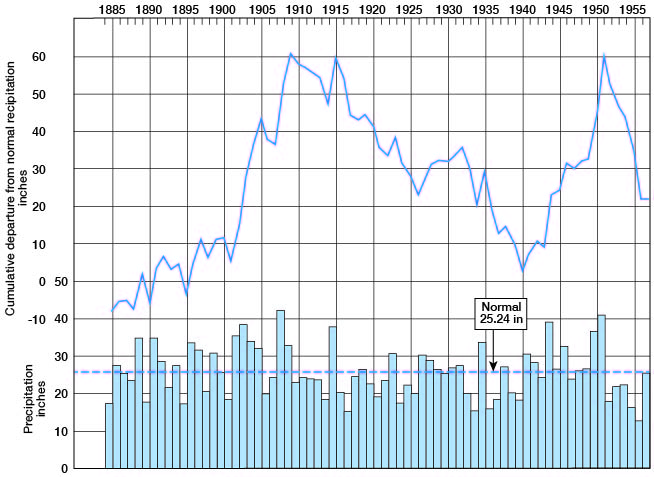
The U. S. Weather Bureau has maintained a precipitation gage at Concordia since 1885. The normal annual precipitation recorded at Concordia is 25.24 inches. The annual precipitation and the cumulative departure from normal for the period of record beginning in 1885 are shown graphically in Figure 3. The annual precipitation has ranged from 15.28 inches in 1934 to 41.8.8 inches in 1908.
Figure 3--Annual precipitation and cumulative departure from normal at Concordia.
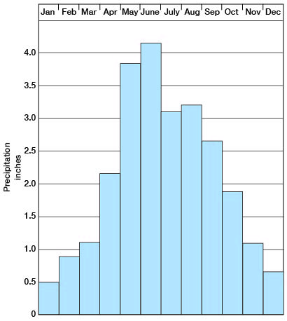
About three-quarters of the precipitation falls during the 6-month period (April through September) that is favorable for growing crops. The normal monthly precipitation at Concordia is shown in Figure 4.
Figure 4--Normal monthly precipitation at Concordia.
The mean annual temperature at Concordia is 53.8° F. The growing season in Cloud County has ranged from 134 to 220 days and averages 186 days. The latest date of a killing frost in the spring is May 19; the earliest date of a killing frost in the fall is September 27.
Population
According to the 1950 census the population of Cloud County was 16,104, an average density of 22.6 inhabitants per square mile as compared with 23.1 for the state. [Note: Cloud County population was listed as 10,268 in 2000 U.S. census, ranking 43rd, with a density of 14.3 (32.9 for the state) (KU Institute for Policy & Social Research).] The census records show a gradual decline in the population of Cloud County of about 100 persons a year in the last 20 years. Urban population has increased steadily while the rural population has decreased. In 1930 the urban population was 8,250 and the rural population 9,756, but in 1950 the urban population was 10,671 and the rural, 5,433. The principal cities and their populations as reported by the 1950 census are: Concordia, 7,175 [5,714 in 2000]; Clyde, 1,067 [740 in 2000]; Miltonvale, 911 [523 in 2000]; Glasco, 803 [536 in 2000]; Jamestown, 494 [399 in 2000]; and Aurora, 221 [79 in 2000].
Transportation
Cloud County has good transportation facilities. All cities are served by one or more railroads. A line of the Chicago, Rock Island and Pacific Railway Co. crosses northeastern Cloud County and serves the city of Clyde. A line of the Missouri Pacific Railroad Co. passes through Clyde, Concordia, and Jamestown. A branch at Yuma serves northern Cloud County, and at Jamestown the line branches to serve northwestern and southwestern Cloud County. The Missouri Pacific Railroad again branches at Jamestown, one branch going southwest to Beloit and the other branch going northwest into Jewell County. A line of the Chicago, Burlington and Quincy Railroad Co. terminates at Concordia. The line of the Atchison, Topeka and Santa Fe Railway Co. passes through Miltonvale and Concordia. A branch line of the Union Pacific Railway Co. from Clay Center in Clay County terminates at Miltonvale, and another branch line of the Union Pacific Railway Co. crosses southwestern Cloud County, passing through Glasco.
In addition to the railroads, State and Federal highways cross Cloud County from north to south and from east to west, offering easy access to the area by automobile and truck. U. S. Highway 81 through Concordia is one of the important north-south highways through the county. U. S. Highway 24 crosses southern Cloud County through Miltonvale and Glasco. Kansas Highway 9 passes through Clyde and Concordia and thence southwest to Beloit, and Kansas Highway 28 from Concordia through Jamestown serves northwestern Cloud County. All state highways are hard surfaced and many county roads are graveled. Most township roads are graded.
Agriculture
Agriculture is the chief occupation in Cloud County. Wheat, corn, oats, sorghums, and tame hay are the principal crops grown, and many cattle, hogs, and poultry are raised. In the valley areas corn, sorghums, and alfalfa are the principal crops; in the uplands wheat, oats, and other cereal grains are the principal crops. The dissected areas between the valleys and uplands are principally pasture. About 90 percent of the 455,040 acres of land area in Cloud County is used for agriculture. Of the total land area in the county in 1955, 27 percent was planted to wheat, 12 percent to sorghums, 6 percent to corn, 3 percent to oats, 7 percent to tame hay, and 1 percent to other crops, and 34 percent was wild hay land and pasture.
Mineral Resources
Construction Materials
Parts of almost all the geologic formations in Cloud County can be used for some type of construction. The principal uses and the geologic source of construction materials in Cloud County are discussed in the following paragraphs.
Concrete aggregate--Aggregate for concrete consists of fragments of hard, durable minerals or rocks of sand and gravel size. The constituent particles should be free from adherent particles or coatings that would interfere with the bonding between the aggregate particles and the cement. A great quantity of sand and gravel for concrete aggregate is available from the Recent alluvium of Republican River. Limestone gravel from the Crete Formation in southwestern Cloud County along the edge of the Solomon River valley is composed of hard crystalline limestone pebbles in a finer matrix predominantly composed of quartz sand. In the basal part of the formation the particles are free of adherent materials and constitute a potential source of aggregate. These deposits are terrace remnants along the present valley walls and are not extensive.
Materials for the manufacture of lightweight aggregate are available from parts of the Dakota Formation, the Graneros Shale, and the silts of the Peoria and Loveland Formations. Such uses are discussed more fully under ceramic materials. Silica-cemented sandstones of the Dakota Formation are available in very small quantity in the county for crushed stone aggregate.
Road metal--Surfacing material consisting of crushed stone or gravel can be produced in large quantities in Cloud County. The sand and gravel from the alluvium of Republican River are available in great quantity for road metal. The limestone gravel from the Crete Formation is available in lesser quantity but is used extensively in the area. A small quantity of silica-cemented "quartzite" of the Dakota Formation and some iron-cemented sandstone can be crushed for road metal. The Greenhorn Limestone is used extensively for road metal, but it has a tendency to form dust in dry weather.
Mineral filler--Large quantities of silt for mineral filler are available from the Peoria and Loveland Formations, and probably also from the silts of the terrace deposits in the major valleys.
Riprap--The quartzitic sandstones of the Dakota Formation are suitable for use as riprap, but these deposits are not extensive. The iron-cemented sandstones of the Dakota Formation, the supply of which is more extensive, can be used if the degree of cementation is great enough. The Greenhorn Limestone is not suitable for riprap because it rapidly disintegrates through freeze-and-thaw action.
Structural stone--Structural stone is any hard dense rock that can be quarried and cut to the desired size and shape. Materials in Cloud County that meet these requirements include parts of the Greenhorn Limestone and the Dakota Formation. The Fencepost Limestone bed at the top of the Pfeifer Shale member of the Greenhorn Limestone is an ideal building stone. The stone is soft and easily quarried in a fresh exposure but "case hardens" after quarrying, and it weathers well. The "Shell-rock limestone bed" at the top of the Jetmore Chalk member also is used as a structural stone, but does not improve on weathering as does the Fencepost bed. The cemented sandstone of the Dakota Formation has been used as structural stone, but owing to uneven cementation of the sandstone it does not weather as well as limestones from the Greenhorn Limestone.
Ceramic Raw Materials
By Norman Plummer
In Cloud County the Dakota Formation is the only important source of clays suitable for use in the ceramic industries. Between 1938 and 1940, 117 samples of clay were obtained from 50 localities in the Dakota Formation in Cloud County. Ceramic tests and a detailed description of the types of clay available were reported (Plummer and Romary, 1947). From some of the more valuable deposits many samples have been collected and tested since 1940.
In Kansas, the clays of the Dakota Formation contain kaolinite as the dominant clay mineral and minor amounts of illite. Owing to the fact that kaolinite is refractory and white firing, the clays of the Dakota Formation fire to relatively light colors ranging from nearly white to buff unless contaminated by iron oxides. Those containing iron minerals fire to colors ranging from dark buff to deep red. The refractory quality of the kaolinite is sufficient to assure resistance to high temperature, although finely divided quartz and other impurities are mixed with it. Such clays are called fire clays. In Cloud County these fire clays range from Low Duty refractories having a pyrometric-cone equivalent of not less than cone 19 (2806° F) to High Duty refractories having a pyrometric-cone equivalent of not less than cone 31 1/2 (3090° F).
The lighter firing clays range in type from ball clay (an extremely plastic, fine-grained, white- to ivory-firing refractory clay) to very siliceous fire clay. The intermediate types, ranging from plastic fire clay to moderately siliceous fire clay, are most abundant and the most extensively used.
Cloud County has one brick plant, Cloud Ceramics, southeast of Concordia, which uses clay from three pits in the Janssen Clay member of the Dakota Formation. This company manufactures face brick ranging from light ivory to purplish red. During 1955 this plant shipped 1,130 carloads of brick. The capacity of Cloud Ceramics was doubled early in 1957 when a large tunnel kiln and an additional factory unit were put in operation.
A plastic fire clay mined from a pit north of Miltonvale was used by the Miltonvale Potteries, Inc., before the plant ceased operations. A small tonnage of clay is still being taken from this pit and sold to small potteries and to schools. Ball clay and plastic fire clay are being sold also from a deposit near the south line of the county in the SW sec. 32, T. 8 S., R. 2 W. At present most of the clay is shipped to schools, amateur potters, and small commercial potteries. Several carloads of clay have been used in the past by the Ludowici-Celadon Co. of Coffeyville, Kansas, in the manufacture of insulating fire brick, kiln furniture, and glazed structural blocks.
Coal
More than 40 percent of the lignite mined in central Kansas was produced from the Dakota Formation in Cloud County (Schoewe, 1952). The Dakota Formation is the surface rock over all or nearly all of 11 of the 20 townships in the county. Test drilling indicates that lignite is present at some level in the Dakota Formation under nearly all the county. Some of these lignite deposits are too thin to have commercial value, some are too deeply buried, and some are of very poor quality.
Coal was mined in Cloud County as early as 1855 at the now abandoned village of Minersville on the county line northeast of Concordia, and coal was mined in this area more or less continuously until 1940. The coal is about 24 inches thick and occurs in two beds separated by about 4 inches of impure coal. The coal lies about 20 feet below the contact between the Dakota and Graneros formations.
Early maps of the area and reports of residents indicate that coal was mined at other localities in the county but on a much smaller scale. Production figures for coal mined in the county are incomplete but indicate that the largest annual amount, 18,000 tons, was produced in 1884. Schoewe (1952) estimates that the original reserves of coal amounted to 5,300,000 tons and that the reserves as of July 1952 amounted to 5,200,000 tons. Inasmuch as all known coal beds in the county are less than 3 feet thick, the known reserves are classed as marginal reserves.
Prev Page--Introduction || Next Page--Geology
Kansas Geological Survey, Geology
Placed on web June 29, 2009; originally published May 1959.
Comments to webadmin@kgs.ku.edu
The URL for this page is http://www.kgs.ku.edu/General/Geology/Cloud/03_geog.html