Kansas Geological Survey, OGI 27
Originally published in 1962 as Kansas Geological Survey Oil and Gas Investigations 27. This is, in general, the original text as published. The information has not been updated. An Acrobat PDF version (5 MB) is also available.
Possible underground natural gas storage sites near the Kansas River Valley are discussed and presently active projects are reviewed. Structural and stratigraphic conditions are favorable for storage near the larger cities in the valley. Artificial (mined) cavities can be used.
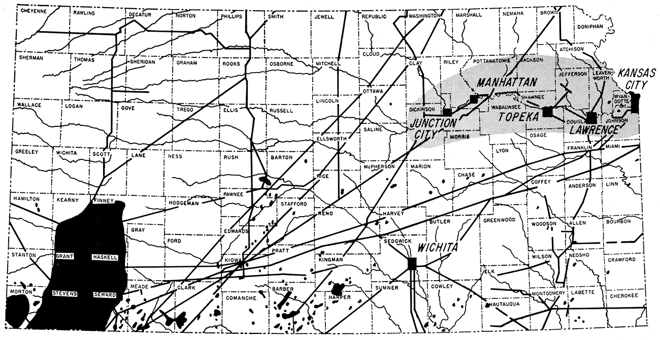
Much of the population of Kansas is concentrated in towns in the Kansas River Valley industrial complex between Junction City and Kansas City. If natural gas from the large fields in Kansas is to be utilized in furthering industrial development, this fuel should be made available to presently developing industrial areas such as this one. Presently, however, only a few small distributing lines are available to supply gas along the Kansas Valley (Fig. 1). These seem adequate to supply present industrial demand except for brief interruption during extreme weather. One major interstate transmission line (Michigan-Wisconsin) crosses the area but does not have an outlet in Kansas; other lines make deliveries in the Kansas Valley only in the Kansas City area.
Figure 1—Map of Kansas showing location of active gas fields, main gas transmission lines, and some cities along the Kansas River Valley.
Because of the seasonal demand for natural gas as a fuel, underground off-season storage has become a significant factor in the over-all economy of gas production, transmission, and consumption. Kansas, located in the heart of the nation geographically, and containing in its southwestern part a portion of one of the nation's largest gas reserves, the Hugoton Gas Area, is a major source of natural gas (Federal Power Commission map, December 31, 1958). A large part of the interstate market for gas from Kansas is the consuming area of north-central United States, Although industrial users consume some of the excess gas available during the seasonal slack in residential use, it is desirable to flatten out the annual curve even more, in order to utilize the pipeline capacity the year around and to stabilize the gas-producing industry in Kansas. This can best be accomplished by off-season storage of gas in underground reservoirs near transmission lines yet available to industrial complexes such as that of the Kansas River Valley. Such offseason storage in industrial areas in north-central United States seems to be a favorable factor for industrial growth.
The interstate shipping of natural gas and the approval of new cross country transmission lines fall under the jurisdiction of the Interstate Commerce Commission and the Federal Power Commission respectively. The apportionment of new lines and approval of transmission of gas are based on considerations of the greatest good to the greatest number of people, on dedicated reserves, and on economic investment values. Thus Kansas, ranking fifth among the gas producing states, third in reserves, yet having a relatively small population, has only a minor voice in the eventual use of the gas produced in the state, The producers desire export of gas for income, some of which returns to the state; the Kansas consumer, domestic or industrial, desires retention of the natural resource within the state's border, arguing that exportation of natural gas is depleting reserves and that the gas should be used to enhance Kansas industrial development. A significant portion of the gas produced in Kansas is being exported, but domestic and industrial use within the state has increased during the last few years, though not necessarily proportionally.
During 1960, according to the U. S. Bureau of Mines report, 73,490,000 thousand cubic feet of natural gas, valued at an average of 56.1 cents per thousand, was consumed in residential use in Kansas, A total of 41,175,000 thousand cubic feet, valued at an average of 53.9 cents per thousand, was consumed commercially. Industrial consumption in Kansas was 257,637,000 thousand cubic feet, part of which was valued at 20.3 cents and part at 14.4 cents per thousand cubic feet. Reported natural gas production (Goebel and others, 1961) totaled 632.6 billion cubic feet. Estimated well head value was only 11 cents per thousand cubic feet. It may be seen readily that about half the gas produced in Kansas is being used within the state.
Goebel and others (1961) report 15 storage projects in Kansas as of December 30,1960. Total reservoir capacity of the two present Kansas River Valley projects, Craig in Johnson County and McLouth in Jefferson and Leavenworth Counties, is 18,989,577 thousand cubic feet (Table 1).
Table 1—Gas Storage Projects in Kansas
| Project and county | Location | Year field disc. |
No. wells |
No. obs. wells |
Acres of formation storage |
Acres controlled |
Prod. depth, average |
Av. net sand thickness, feet |
Date first injection |
Capacity, M c. f. | Zone | |||
|---|---|---|---|---|---|---|---|---|---|---|---|---|---|---|
| Working gas |
Cushion gas** |
Total reservoir |
||||||||||||
| Cities Service Gas Company | ||||||||||||||
| 1. Alden, Rice (Pending) | 1937 | 12 | 0 | 711 | 2,695 | 3,320 | 18 | 5,000,000 | 10,857,469 | 15,857,469 | "Misener" Devonian? |
Max. pressure, 1,120 lb. |
||
| 2. Boyer, Butler | Parts of sec. 5, 6, 7, 8, 9, 16, 17, 18, 20, T. 26 S., R. 5 E. | 1916 | 14 | 3 | 1,220 | 2,840 | 880 | 10 | 6/27/1929 | 392,279 | 627,588 | 1,019,867 | Wabaunsee (formerly Shawnee) (Penn) | Max. pressure, 250 lb.; withdrawals direct from pipeline: no compressors. |
| 3. Colony, Anderson | Parts of sec. 31, 32, 33, T. 22 S., R. 19 E; 1, 12, 13, T. 23 S., R. 19 E; 5, 6, 8, T. 23 S., R. 19 E. | 1921 | 82 | 1 | 1,345 | 4,846 | 882 | 47 | 3/31/1953 | 4,148,104 | 5,055,561 | 9,203,665 | "Colony" (Penn) | Max. pressure 280 lb. |
| 4. Craig, Johnson | Parts of sec. 9, 10, 11, 12, 13, 14, 15, 16, 17, 19, 20, 21, 22, 23, 24, 25, 26, 27, 28, 29, 30, 33, 34, 36, T. 12 S., R. 23 E; 1,2,3, 4, 10, 11, 12, 14, 15, T. 13 S., R 23 E. | 1923 | 61 | 24 | 2,360 | 14,967 | 582 | 23 | 5/1931 | 1,557,945 | 4.517,875 | 6.075,820 | "Bush City" (Penn) | Max. pressure, 205 lb. |
| 5. Elk City, Elk and Montgomery | Parts of sec. 11, 13, 14, 23, 24, 25, 26, 35, 36, T. 31 S., R. 13 E; 19, 30, 31, T. 31 S., R. 14 E; 1, 2, T. 32 S., R. 13 E; 6, T. 32 S., R. 14 E; 15, 22, 27, 34, T. 31 S., R. 13 E; 3, T. 32 S., R. 13 E. | 1918 | 53 | 6 | 2,0;;7 | 8,319 | 1,354 | 30 | 4/22/1958 | 4,500,000 | 15,500,000 | 20,000,000 | "Burgess" (Penn) | Max. pressure, 630 lb. |
| 6. McLouth, Jefferson and Leavenworth | Parts of sec. 15. 16, 17, 18, 19, 20, 21, 22, 26, 27, 28, 29, 30, 31, 32, 33, 34, 35, 36, T. 9 S., R. 20 E; 25, 36, T. 9 S., R. 19 E; 4, 5, 6, 7, 8, 9, T. 10 S., R. 21 E; 1, 2, 3, 4, 5, 6, 7, 8, 9, 10, 11, 12, 17, 18, 19, 20, T. 10 S., R. 20 E. | 1940 | 114 | 6 | 5,390 | 22,725 | 1,427 | 18.4 | 4/27/1954 | 5,212,337 | 7,701,420 | 12,913,757 | "Bartlesville" (Penn) | Max. pressure, 500 lb. |
| 7. Piqua, Allen and Woodson | Parts of sec. 34, 35, 36, T. 34 S., R. 17 E; 1, 2, 3, 4, 9, 10, 11, T. 25 S., R. 17 E. | 1922 | 30 | 8 | 1,090 | 4,390 | 898 | 20.4 | 8/8/1955 | 1,551,042 | 1,679,430 | 3,230,472 | "Colony" (Penn) | Max. pressure, 295 lb.; withdrawals direct from pipeline: no compressors. |
| 8. North Welda, Anderson | Parts of sec. 16, 17, 18, 20, 21, 22, 23, as, 26, 27, 28, 29, 34, 35, T. 21 S., R. 19 E. | 1921 | 75 | 6 | 2,125 | 6,006 | 893 | 29 | 5/22/1934 | 4,521,646 | 5,500,000 10,021,646 | "Colony" (Penn) | Max. pressure, 280 lb. | |
| 9. South Welda, Anderson | Parts of sec. 2, 3, 4, 9, 10, 11, 14, 15, 16, 21, 22, 23, 26, 27, 28, T. 22 S., R. 19 E. | 1921 | 105 | 6 | 2,528 | 7,595 | 921 | 32 | 7/12/1937 | 5,313,617 | 6,475,569 | 11,789,186 | "Colony" (Penn) | Max. pressure, 280 lb. |
| Consolidated Gas Utilities Corporation | ||||||||||||||
| 10. Gibson (Collinson), Cowley | Parts of sec. 29, T. 34 S., R. 3 E. | 2 | 0 | 240 | 1,435 | 18 | 10/1947 | 647,270 | 425,730 | 1,073,000 | Severy sh. (Penn) | |||
| Union Gas System, Inc. | ||||||||||||||
| 11. Buffalo, Wilson | Parts of sec. 6, 7, 8, 17, 18, T. 27 S., R. 16 E. | 1916 | 26 | 1 | 1,708 | 1,708 | 182 | 15 | 5/1942 | 2,524,175* | 4,130,583 | 8.250,000 | Iola Ls. (Penn) | Injection from high-pressure transmission lines |
| 12. Fredonia, Wilson | Parts of sec. 8, 9, 16, 17, 20, T. 29 S., R. 15 E. | 1915 | 17 | 1 | 1,980 | 1,980 | 248 | 25 | 8/1949 | Kansas City (Cottage Grove or Noxie) "Layton" (Penn) | Injection from high-pressure line | |||
| 13. Liberty South, Montgomery | Parts of sec. 3, 4, 5, 8, 9, T. 34 S., R. 17 E. | 1914 | 18 | 3 | 1,565 | 1,565 | 428 | 35 | 6/1948 | "Squirrel" (Penn) | From high-pressure line | |||
| 14. Liberty North, Montgomery | Parts of sec. 21, 22, 27, 28, 32, 33, 34, T. 33 S., R. 17 E. | 1914 | 19 | 2 | 3,002 | 3,002 | 428 | 35 | 4/1954 | "Squirrel" (Penn) | From high-pressure line | |||
| 15. Longton, Chautauqua | Parts of sec. 2, 3, 4, 9, 10, T. 32 S., R. 12 E. | 1916 | 33 | 1 | 3,280 | 3,280 | 659 | 30 | 3/1940 | "Layton" (Penn) | From high-pressure line | |||
| * Plus unused capacity 1,595,242 M c. f. as of 12/22/1959 ** Minimum retained for pressure maintenance. |
||||||||||||||
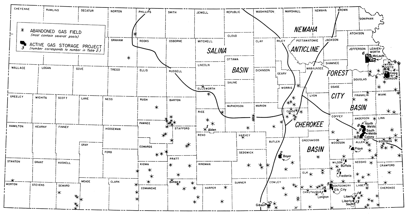
Kansas can be divided into several petroliferous provinces (Merriam and Goebel, 1956) coinciding with ancient structural provinces (Fig. 2), formed by tectonic movements in or just before Middle Pennsylvanian time. Still older structures, some having different orientation, were thereby modified or even obliterated. Subsequent movements have not produced much additional change in major features, although numerous small structures have been superimposed, including some of the oil and gas traps. Very few of the structures are indicated by anomalous position or attitude of surface rocks.
Figure 2—Map of Kansas showing location of abandoned gas fields, active gas storage projects, and major post-Mississippian structural provinces in eastern Kansas.
A generalized cross section of rocks in northeastern Kansas from Clay County to Kansas City, Missouri, is given in Figure 3. In Kansas, virtually all rocks above the Precambrian floor are sedimentary and almost horizontal. (Please note that in the cross section, vertical exaggeration is 100 times.) Many of the layers are relatively porous and permeable; data pertinent to gas storage in the Kansas River Valley are listed in Table 2.
Table 2—Stratigraphy of Kansas in reference to gas storage in rocks in the Kansas River Valley
| System | Smaller stratigraphic divisions |
General data | Remarks in reference to gas storage |
Approx. thickness, feet |
|
|---|---|---|---|---|---|
| Permian | Wolfcampian Stage, containing Chase, Council Grove, and Admire Groups | Crops out in east-central Kansas. Chiefly marine shales and limestones. Thicker shales commonly variegated. Limestones massive to thin bedded. Shales mostly lack carbonaceous materials. Lower part contains some sandstone. | Sandstones in lower part (and some not differentiated from sandstones in underlying Wabaunsee Group) bear gas and are suitable reservoirs for storage in anticlinal structures as along Nemaha Anticline. Great Hugoton gas pool is in deeply buried stratigraphic trap in southwestern Kansas. | 500 | |
| Pennsylvanian | Wabaunsee, Shawnee, Douglas, and Pedee Groups | Principally shales, limestones, and sandstones; a few thin coal beds. Sandstones lenticular or elongate. Thickest formations chiefly shale as much as 200 feet thick. Solid limestone sections generally less than 50 feet thick. Sandstones generally silty, carboniferous, and clayey, as much as 50 feet thick. Many oil and gas traps. | Sandstones throughout section, but more extensive in lower part, offer many reservoirs in an area extending many miles west of outcrops. | 750 | |
| Lansing, Kansas City, Pleasanton, Marmaton, and Cherokee Groups | More or less similar to units next above. Many oil and gas traps, especially in sandstones in Cherokee Group. Outcrop belt in eastern Kansas, Kansas City area to Oklahoma line, subsurface in all Kansas west of outcrop area. | Potential storage reservoirs in many parts of section. Sandstones in lower part are suited as reservoirs in many small anticlinal structures in eastern Kansas. Important in Kansas City area. | 1,250 | ||
| Mississippian | Meramecian, Osagian, and Kinderhookian Stages | Chiefly massive limestones. Subsurface only. Oil traps, especially not far below upper eroded surface that cuts across various formations. | Probably of little interest at present time. (McLouth Field) | 0-400 | |
| Mississippian or Devonian |
Boice Shale and Chattanooga Shale | Dark to light greenish-gray shale, silty or dolomitic, some red; also black and gray shale. | Probably of little interest. | 50-100 | |
| Devonian and Silurian |
"Hunton" Limestone | Principally dolomite, some limestone. Identified in Kansas only in central and northeastern parts. | Probably of little interest. | 0-300 | |
| Ordovician | Sylvan Shale or Maquoketa Shale | Greenish-gray, silty, dolomitic shale restricted principally to area of ancient Northeast Kansas Basin. | Probably of little interest. | 0-155 | |
| Viola Limestone (Kimmswick) | Dolomite and limestone. Subsurface in most of state, but absent on principal uplifts. | Probably of little interest. | 0-300 | ||
| Simpson Group | Includes Platteville Formation, St. Peter Sandstone, and lower beds. Dolomitic limestones and sandstones. | Probably of interest in the future. | 0-100 | ||
| Arbuckle Group | Cotter and Jefferson City Dolomites | Mainly coarsely granular, cherty dolomite. | 0-200 | ||
| Roubidoux Sandstone | Sandy dolomite and fine-grained sandstone. | 0-167 | |||
| Cambrian | Gasconade Dolomite and Van Buren Formation | Mainly cherty, coarse-grained dolomite. Gunter Sandstone in basal part of Van Buren Formation. | 0-200 | ||
| Eminence Dolomite | Cherty, buff to white, very coarsely granular and crystalline dolomite. | 0-260 | |||
| Bonneterre Dolomite | Glauconitic, noncherty dolomite. | 0-130 | |||
| Lamotte Sandstone | Ill-sorted, round to angular, coarse- to fine-grained sandstone. ("Granite wash" of various ages lies on Precambrian rocks in several parts of Kansas.) | 0-80 | |||
| Precambrian rocks | Igneous and metamorphic rocks of the basement complex. Underlie all of state; nearest to land surface in Nemaha County in northeastern Kansas. | ||||
The Kansas River Valley industrial complex, defined as the river valley from Junction City to Kansas City, may be located in Figure 1. The complex transgresses two major structural features of northeastern Kansas, the Forest City Basin and the Nemaha Anticline.
The Forest City Basin is a low broad structural feature centered in northeastern Kansas but extending into adjacent states. The basin was formed by downwarping of pre-Pennsylvanian rocks, and it was both a topographic and a structural feature in which the Pennsylvanian rocks in this part of Kansas were deposited (Fig. 3). Gentle folding throughout the geologic past produced low domes, anticlines, and noses, some of which are discernable in outcropping rocks. Most of the small uparched features that are measurable in surface rocks are more pronounced in the subsurface, and they may serve as oil and gas traps. Some "structural traps" in Pennsylvanian rocks in eastern Kansas have no or very little surface indication; some structures that are traps in pre-Pennsylvanian sediments are completely concealed. Examples of various kinds of oil and gas reservoirs in the Forest City Basin are discussed in detail by Jewett (1954).
Figure 3—Generalized cross section from Clay County along Kansas River, depicting the sequence of rocks and their present attitude as far east as the Kansas-Missouri line.
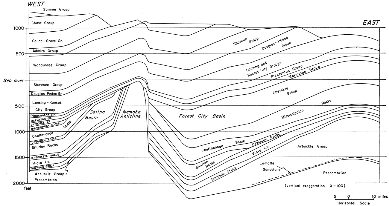
The Nemaha Anticline crosses the western end of the Kansas River Valley. It is a major post-Mississippian element that crosses Kansas from Nemaha County to Sumner County and extends into Nebraska and Oklahoma. It is discernible in surface rocks along most of its length but is much more pronounced in subsurface and is believed to be faulted in many places along the steeper eastern flank (Jewett, 1951). The Nemaha Anticline is referred to by some as the Nemaha "mountains", because Precambrian crystalline rocks lie at comparatively shallow depths along the axis of the uplift. Lee (1943) discussed in detail the structural history of the Nemaha Anticline. Mississippian and older rocks are tilted and eroded along the flanks of the anticline (Fig. 3), and Pennsylvanian strata overstep and overlap rocks ranging in age from Precambrian to Mississippian. Pennsylvanian sediments lie on Precambrian rocks in a belt extending northwest from a point in T. 10 S., R. 10 E, into Nebraska, and in isolated areas farther south.
The gas storage projects presently operating in eastern Kansas, for example Cities Service Gas Company's McLouth project (Table 1), utilize structural traps. It is believed that in almost all counties in the Forest City Basin area, structural conditions can be found where porous Pennsylvanian rocks would be suitable for gas storage.
"Shoestring sand" oil and gas pools at depths ranging from about 1,000 to 1,200 feet are plentiful in the southern part of the Forest City Basin. Abandoned gas fields lie above many of them. It is reasonable to believe that gas could be stored successfully in many of these sandstone bodies, including some that have yielded gas and oil and some that have been known to contain only water.
In addition to the general conditions described, some specific structures in eastern Kansas may be mentioned (Jewett and Goebel, 1960); they indicate deviations from the general or regional westward dip of outcropping rocks. In the vicinity of Kansas City, the Morris Anticline is one of several folds that can be measured in surface rocks in the lower Kansas River Valley. Other similar structures are situated near Bonner Springs, De Soto, and Eudora, and in several other places. Because of cultural or other conditions in the areas, some may not be suited for gas storage projects.
As shown in Table 1, Cherokee sandstones are now most extensively used for gas storage. It is reasonable to expect that sandstones in the Marmaton and Cherokee Groups in the area near Kansas City will be of increasing interest as potential storage reservoirs (Jewett and Goebel, 1960).
It is possible that sandstones in the Simpson Group (Ordovician age) in the Kansas River Valley may be utilized as reservoirs for gas storage in the future. These rocks are absent from major uplifts, but elsewhere in the state they are widespread. In the Kansas City area, depth of the Simpson rocks is about 1,550 feet.
Throughout much of the area on the northern part of the Nemaha Anticline there are potential gas storage reservoirs, especially in Pennsylvanian rocks at depths of a few hundred feet. Not much geologic study would be required to determine suitable sites for storage reservoirs along the anticline. Specifically, the part north of the Kansas River, especially in the vicinity of Wamego, should contain important potential storage sites.
Arbuckle rocks are absent from the northern part of the Nemaha Anticline and adjacent areas as far west as eastern Washington County and northeastern Clay County. Elsewhere, gas storage in Arbuckle rocks seemingly is possible. Except in a few places, Precambrian rocks in Kansas generally lack porosity sufficient for gas storage, but LaMotte Sandstone next above the Precambrian rocks could conceivably be usable.
Although at present natural gas is stored underground in Kansas only in geologic structures that are natural gas reservoirs, storage in artificial reservoirs has been found to be practical in adjacent states. In Colorado, near Denver, gas is stored in an abandoned coal mine (Bleakley, 1961). At Ponca City, Oklahoma, cavities have been excavated in limestone in order to create space for storage of natural gas liquids (Jordan, 1961).
Coal has been mined at various times in and near the Kansas River Valley (Bowsher and Jewett, 1943; Schoewe, 1946, 1951), but the only coal mines in the area potentially practical for low-pressure gas storage are in Osage County, about 20 miles south of Topeka. There the Nodaway coal bed (Howard Formation) has been extensively mined, chiefly by open pits, but as late as 1938 about 20 shaft mines were operating at depths of 25 to 120 feet, and a few shaft mines have been operating intermittently in recent years. Underground, most of the coal was mined by the long-wall method, hence no sizable openings are believed to be present. The effect of mining operations on porosity and permeability of the rocks is not known. Presence of water in the mines should be no major deterrent, but storage pressure would be limited by the shallow depths.
Limestone has been quarried in extensive underground workings in the Kansas City area. Mines in nearly horizontal limestone beds are being used for refrigerated food warehouses near Morris in Wyandotte County and in Leavenworth County a few miles southwest of Bonner Springs. Storage pressure in shallow mined limestones would also be limited by the depth-pressure relationships. Probably such storage would be limited to liquified gases.
Considerable unused space is available in other limestone mines in the Kansas City area. Portals leading to extensive abandoned underground workings to the south and west are situated a short distance west of 34th Street, Kansas City, Kansas, about lJz mile north of the north boundary of Maple Hill Cemetery (NE NE SE sec. 30, T. 11 S., R. 25 E.). Thickness of overburden over the mined-out space exceeds 100 feet. The Argentine Limestone Member of the Wyandotte Formation was exploited for crushed stone from this mine. The Bethany Falls Limestone (Swope Formation) is being mined at a depth of about 130 feet, a short distance north of the Kansas Turnpike not far from its eastern terminus.
Throughout the length of the Kansas River Valley the bed rock, principally shale and limestone, bordering and below the alluvial flood plain generally dips almost imperceptibly to the north of west. Throughout the upper 2,000 feet of strata there are many shale units ranging in thickness from a few feet to several tens of feet lying between limestone formations. These shale formations can be readily excavated to provide satisfactory storage space.
Under the state statues covering eminent domain, favorable underground storage sites may be made available to gas public utilities in the public interest. Specifically, as taken from the 1959 Supplement to General Statues of Kansas 1949, Corrick, Chapter 55, Article 12 (55-1203) the statute states, "APPROPRIATION OF CERTAIN PROPERTY. Any natural gas public utility may appropriate for its use for the underground storage of natural gas any subsurface stratum or formation in any land which the commission (State Corporation Commission) shall have found to be suitable and in the public interest for the underground storage of natural gas, and in connection therewith may appropriate such other interests in property as may be required adequately to examine, prepare, maintain and operate such underground natural gas storage facilities. The right of appropriation hereby granted shall be without prejudice to the rights of the owner of said lands or of other rights or interests therein to drill or bore through the underground stratum or formation so appropriated in such manner as shall comply with orders, rules and regulations of the commission issued for the purpose of protecting underground storage strata or formations against pollution and against the escape of natural gas therefrom and shall be without prejudice to the rights of the owner of said lands or other rights or interests therein as to all other uses thereof."
In almost all parts of Kansas, geologic conditions are favorable for economical storage of natural gas in porous rocks. Fortunately, near the centers of larger population and industries (greater Kansas City, Wyandotte County, population 184,357; Johnson County, population 141,694; and Topeka, Shawnee County, population 144,357) natural reservoirs at comparatively shallow depth are believed to be sufficient for storing gas in as large quantities as may be desired in the foreseeable future.
The purpose of this report is to call attention to the conditions favorable for underground storage of natural gas in the vicinity of the Kansas Valley. Because only a hint of the detailed geologic and engineering knowledge in the area could be included herein, a selected list of references is presented, which may serve as a starting point for additional inquiry.
Bleakley, W. B., 1961, Old coal mine converted to gas storage: Oil and Gas Journal, v. 59, no. 51, p. 88-90, 92, 94.
Bowsher, A. L., and Jewett, J. M., 1943, Coal resources of the Douglas Group in east-central Kansas: Kansas Geol. Survey, Bull. 46, p. 1-94. [available online]
Farquhar, O. C., 1957, The Precambrian rocks of Kansas: Kansas Geol. Survey, Bull. 127, pt. 3, p. 49-122. [available online]
Federal Power Commission, 1959, Major natural gas pipelines as of December 31, 1958, (map) F.P.C. M-53.
Frye, J. C., and Leonard, A. B., 1952, Pleistocene geology of Kansas: Kansas Geol. Survey, Bull. 99, p. 1-230. [available online]
Goebel, E. D., 1958, The petroleum industry in Kansas: Kansas Geol. Survey, Oil and Gas Inves. 18, map.
Goebel, E. D., and others, 1961, Oil and gas developments in Kansas during 1960: Kansas Geol. Survey, Bull. 155, p. 1-229.
Hilpman, P. L., 1958, Producing zones of Kansas oil and gas fields: Kansas Geol. Survey, Oil and Gas Inves. 16, maps, p. 1-10.
Jewett, J. M., 1951, Geologic structures in Kansas: Kansas Geol. Survey, Bull. 90, pt. 6, p. 105-172. [available online]
Jewett, J. M., 1954, Oil and gas in eastern Kansas: Kansas Geol. Survey, Bull. 104, p. 1-397.
Jewett, J. M., 1956, Kansas: in Underground storage of liquid hydrocarbons in the United States; Interstate Oil Compact Commission, Oklahoma City, p. 26-34.
Jewett, J. M., 1958, Subsurface geology of Kansas and its relation to accumulation and production of oil and gas: Interstate Oil Compact Commission, Oil and Gas Compact Bull., v. 17, no. 2, p. 35-44.
Jewett, J. M., 1959, Graphic column and classification of rocks in Kansas: Kansas Geol. Survey, (chart), 25" x 38".
Jewett, J. M., and Goebel, E. D., 1960, Underground storage of natural gas in Kansas: Kansas Geol. Survey, Oil and Gas Inves. 21, p. 1-18.
Jewett, J. M., and Merriam, D. F., 1959, Geologic framework of Kansas-a review for geophysicists; in, Symposium on geophysics in Kansas: Kansas Geol. Survey, Bull. 137, p. 9-52. [available online]
Jewett, J. M., and Newell, N. D., 1935, Geology of Wyandotte County, Kansas: Kansas Geol. Survey, Bull. 21, pt. 2, p. 151-162. [available online]
Jordan, L., 1961, LPG cavern in Wreford Limestone, Kay County, Oklahoma: Oklahoma Geol. Survey, Oklahoma Geol. Notes, v. 21, no. 10, p. 250-255.
Kansas Geological Society, 1960, Kansas oil and gas fields, v . 3, northeastern Kansas, p. 1-220.
Keroher, R. P., and Kirby, J. J., 1948, Upper Cambrian and Lower Ordovician rocks in Kansas: Kansas Geol. Survey, Bull. 72, p. 1-140. [available online]
Leatherock, Constance, 1945, The correlation of rocks of Simpson age in north-central Kansas with the St. Peter Sandstone and associated rocks in northwestern Missouri: Kansas Geol. Survey, Bull. 60, pt. 1, p. 1-16. [available online]
Lee, Wallace, 1939, Relation of thickness of Mississippian limestone in central and eastern Kansas to oil and gas deposits: Kansas Geol. Survey, Bull. 26, p. 1-42. [available online]
Lee, Wallace, 1940, Subsurface Mississippian rocks of Kansas: Kansas Geol. Survey, Bull. 33, p. 1-114. [available online]
Lee, Wallace, 1943, The stratigraphy and structural development of the Forest City Basin in Kansas: Kansas Geol. Survey, Bull. 51, p. 1-142. [available online]
Lee, Wallace, 1956, Stratigraphy and structural development of the Salina Basin area: Kansas Geol. Survey, Bull. 121, p. 1-167. [available online]
Lee, Wallace, Leatherock, Constance, and Botinelly, Theodore, 1948, The stratigraphy and structural development of the Salina Basin of Kansas: Kansas Geol. Survey, Bull. 74, p. 1-155. [available online]
Lee, Wallace, and Merriam, D. F., 1954, Cross sections in eastern Kansas: Kansas Geol. Survey, Oil and Gas Inves. 12, cross secs., p. 1-8.
Merriam, D. F., and Goebel, E. D., 1956, Kansas structural provinces offer varied types of traps: Oil and Gas Journal, v. 54, no. 52, Apr. 30, p. 141-154.
Moore, R. C., Frye, J. C., and Jewett, J. M., 1944, Tabular description of outcropping rocks in Kansas: Kansas Geol. Survey, Bull. 52, pt. 4, p. 137-212. [available online]
Moore, R. C., and others, 1951, The Kansas rock column: Kansas Geol. Survey, Bull. 89, p. 1-132. [available online]
Rich, J. L., 1926, Further observations on shoestring oil pools in eastern Kansas: Am. Assoc. Petroleum Geologists Bull., v. 10, p. 568-580.
Schoewe, W. H., 1946, Coal resources of the Wabaunsee Group in eastern Kansas: Kansas Geol. Survey, Bull. 63, p. 1-144. [available online]
Schoewe, W. H., 1951, Coal resources of the Permian System in Kansas: Kansas Geol. Survey, Bull. 90, pt. 3, p. 53-68. [available online]
Whitla, R. E., 1940, Coal resources of Kansas: post-Cherokee deposits: Kansas Geol. Survey, Bull. 32, p. 1-64. [available online]
Kansas Geological Survey
Placed on web Sept. 1, 2018; originally published in 1962.
Comments to webadmin@kgs.ku.edu
The URL for this page is http://www.kgs.ku.edu/Publications/Bulletins/OGI27/index.html