Kansas Geological Survey, Bulletin 90, part 3, originally published in 1951
Originally published in 1951 as Kansas Geological Survey Bulletin 90, part 3. This is, in general, the original text as published. The information has not been updated.
Between 1922 and 1934 approximately 10,000 tons of coal of Permian age was mined several miles north of Harveyville in southeastern Wabaunsee County. This report describes the location of the mines, the stratigraphic position, thickness, and physical character of the coal, the history of mining in the district, and the calculation of the coal reserves. In addition, a second Permian coal is located in Geary County. The coal is described and a detailed stratigraphic section measured at the mine locality is presented. Reference is made to all stratigraphic positions where coal is known to occur in Permian rocks in Kansas.
Purpose of report--Of the 261,371,483 tons of coal that have been mined in Kansas between 1869 and the close of 1949, all but approximately 310,184 tons were produced from Pennsylvanian strata. The rest of the coal was mined from Cretaceous (300,184 tons) and Permian (10,000 tons) rocks. Although several thin seams of coal were known to occur in the Permian rocks in Kansas, it was not realized or known until 1944 that the 10,000 tons of coal mined from Permian strata in the southeastern part of Wabaunsee County (Fig. 1) between 1922 and 1934 was Permian coal. A second Permian coal mine locality was discovered still later in Geary County (Fig. 1). The purpose of this report is to put on record the mining of Permian coal in Kansas, to present data on its production and reserves, both proved and potential, and to direct attention to the various stratigraphic horizons where coal occurs in Kansas Permian rocks. This short report is also part of the coal inventory studies started by the State Geological Survey of Kansas in 1942.
Figure 1--Map of Geary and Wabaunsee Counties, Kansas, showing location of Permian coal mines and traces of the Brownville limestone which marks the separation of the Pennsylvanian from the Permian System of rocks in Kansas.
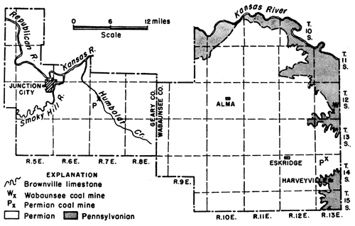
Field investigations--The now abandoned Permian coal mines in Wabaunsee County were located in the fall of 1944 while tracing the coals of the Wabaunsee group (Pennsylvanian). Existence of a mine in southeastern Wabaunsee County near Harveyville was noted in reports of the State coal mine inspector for the years 1925, 1928, 1929, and 1931. These reports did not indicate, however, from what stratigraphic horizon the coal came. The published general location for the mine was in error but, with the help of local residents, two old mines were found in a pasture 2 to 3 miles south of the published location. A hasty examination of the local geology, together with information obtained from Mr. J. C. Bell, a farmer living close to the former mines, established the age of the coal-bearing rocks as Permian rather than Pennsylvanian.
The mining of coal along Humboldt Creek several miles east of Junction City in Geary County was reported to me by Mr. Sam C. Walker, owner and operator of the Walker Stone Company. Knowledge of the general geology of Geary County made it obvious that this coal was also Permian in age. Hay (1893, p. 8; 1896, pp. 17, 21) as early as 1893 reported the presence of coal along Humboldt Creek and referred to it as Permo-Carboniferous in age.
Acknowledgments--I wish to thank Mr. Merle L. Sowell, tunnel superintendent for the Denver, Colorado, Water Department, formerly of Admire, Kansas, and operator for two years of the Permian coal mine north of Harveyville in Wabaunsee County, and Mr. J. C. Bell, a local resident near the former mines, for much of the information concerning the history of the mining project described in this report. Thanks are extended also to Mr. Sam C. Walker of Junction City for information and the location of the Geary County Permian coal deposit. Dr. John M. Jewett and Mr. Howard O'Connor, both of the State Geological Survey of Kansas, aided materially in determining the exact stratigraphic horizons at which the Wabaunsee County Permian coal occurs.
Location of mines--The Permian coal mines in Wabaunsee County are located in a broad shallow draw (Pl. 1A) in the NE sec. 8, T. 14 S., R. 13 E., in the southeastern part of Wabaunsee County (Fig. 2). The mines, now abandoned and represented only by dump, heaps, are 4 1/2 miles north and 1 1/2 miles west of the center of Harveyville or 5 1/2 miles due east of Eskridge along the county road. The mines are on the south side of the road, in a pasture approximately a quarter of a mile from the road. The location of the main mine is indicated by a mine dump heap and a windmill erected over the abandoned shaft of the mine (Pl. 1B). About 300 feet due east of the main mine is the mine dump of another mine (Pl. 1C).
Figure 2--Map of the Harveyville mining district in southeastern Wabaunsee County, Kansas, showing location of coal mines, potential coal reserve lands, and trace of the Americus limestone.
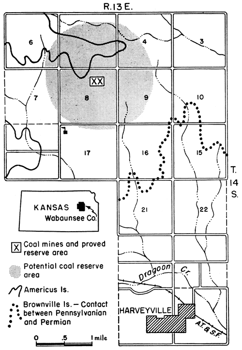
Plate 1--Permian Wabaunsee coal mines, NE sec. 8, T. 14 S., R. 13 E. A, Easternmost mine dump showing location in shallow and broad draw. B, View showing relation of eastern-most mine to westernmost or main mine. Windmill over abandoned shaft. C, Mine dump of eastern-most mine.
![]()
Stratigraphic position of the coal--The only rocks exposed near the former mines are along the section line roads and along the shallow banks of the stream that traverses the pasture. The best exposure is a quarter of a mile north of the mines along the Eskridge road, where the rocks exposed consist of limestone, shale, and sandstone as shown in the section below.
| Measured section along Eskridge road, NE sec. 8, T. 14 S., R. 13 E. | Feet | Inches | ||
|---|---|---|---|---|
| Permian--Wolfcampian | ||||
| Five Point limestone | ||||
| Limestone, fossiliferous, thin slabs | 1 | 6 | ||
| West Branch shale | ||||
| Shale, buff, limy, fossiliferous, lower part sandy, bedded | 7 | 3 | ||
| Limestone, impure, dark-gray, shelly on weathering | 1 | 3 | ||
| Sandstone, soft, more or less bedded | 3 | 0 | ||
| Sandstone, massive (exposed) | 2 | 0 | ||
A careful search in the surrounding sections of land by Jewett, O'Connor, and me resulted in definitely establishing the coal horizon in the West Branch shale of the Admire group, Wolfcampian Series. The limestone exposed along the Eskridge road just north of the mines was identified as the Five Point limestone.
Physical character of the coal--No published description of the coal or much information concerning it are to be had. As reported by Mr. Sowell, who leased and operated one of the mines in 1929 and 1930, the coal had a thickness of 28 to 32 inches, The coal was without block seams and therefore was very difficult to break down in the long-wall system of mining which he used. Later the coal was drilled and shot with black powder with good results. The coal had a high ash content and burned almost sootless. Mr. J. C. Bell, who lives about one-half mile east of the abandoned shaft mines, reported that two seams of coal were penetrated in sinking the shaft. In the first shaft dug, which was only 18 feet deep, the coal was 17 inches thick on the north side of the shaft and 21 inches on the south side, only 5 feet away. In another shaft 32 feet deep and about 300 feet west of the first shaft, the coal measured 34 inches in thickness. In this shaft an 11-inch coal was present at a depth of 12 to 13 feet below the surface. Whether the coal encountered in the first shaft is to be correlated with the 11-inch coal in the second shaft or with the lower 34-inch coal seam is not clear. From differences in surface elevations between the two shafts as measured by hand level in the field, it seems that the coal encountered in the first shaft is to be correlated with the 11-inch seam in the second shaft.
History of mining--The coal was originally discovered by Jerry Harvey, a farmer, in 1918 while digging a stock well in his pasture. A prospect hole sunk immediately found the coal to be 13 inches thick and of fair quality. Efforts to mine the coal, however, were soon abandoned because of the great quantity of water flooding the prospect mine. In 1922 a local coal company composed largely of Harveyville men undertook to mine the coal. After prospecting the pasture with test holes, they estimated that 20 acres were underlain by minable coal. The company sank a new shaft farther up slope from the original prospect mine which encountered 30 inches of coal. The main tunnel of the mine was driven south from the shaft opening. After extending the main tunnel for 700 feet the mine was abandoned because of excessive water and a new shaft was sunk 600 feet west and 45 feet deep. The coal in this mine, according to Sowell who later leased and operated it in 1929 and 1930, had a thickness of 28 to 32 inches. Because of the overabundance of water the mining of the coal was difficult. The miners had to lay in mud and water in order to work the mine, a condition not only unfavorable to the miner, but also to the sale of the coal because of its muddy character. The excessive water, high ash content, muddy nature of the coal when mined, weak sandy rock forming the roof of the mine, and the general conditions prevailing during the depression years of the early 1930's finally caused the suspension and abandonment of the Permian coal mining operations. Today a windmill over the shaft opening of the last worked mine (Pl. 1B) pumps ample supplies of stock water for the cattle grazing in the large pasture.
Coal production--Published data on the amount of coal mined is incomplete. In the reports of the State coal mine inspectors for 1925 (Sherwood, 1926, pp. 66-67, 92-93), 1928 (Sherwood, 1929, pp. 62-63, 84-85), 1929 (Sherwood, 1930, pp. 60-61, 79-79), and 1931 (Keegan, 1932, pp. 60-61, 80-81) coal production totaling 1,540 tons is given for a mine or mines located 6 miles north and 1 1/2 to 2 miles west of Harveyville in Wabaunsee County. The mines described in this report are only 4 1/2 miles north and 1 1/2 miles west of Harveyville and undoubtedly are the same ones referred to in the reports of the State coal mine inspectors, as no other mines were found in that part of the county and local residents living close to the mines knew of no others. According to Sowell (personal communication), approximately 10,000 tons of coal were mined between 1922 and 1934, the period representing the coal mining activity of this mining district.
Coal reserves--When the Harveyville coal mining company was organized in 1922 and a survey made of the extent of the coal deposit, it was estimated that at least 20 acres were underlain by minable coal. The area covered by this survey, however, is not known. On the basis of 20 acres of reserve land, the proved original reserves underlain by coal averaging 30 inches in thickness amounts to 90,000 tons of coal. Of this amount 10,000 tons have been mined, thus leaving a proved reserve of 80,000 tons of coal. If, on the other hand, it is assumed that the coal underlies 1 square mile, the basis adopted by the State Geological Survey of Kansas for estimating proved reserves of coal (Abernathy, Jewett, and Schoewe, 1947, p. 14) then 2,880,000 tons of coal constitute the original proved reserve and 2,870,000 tons the unmined proved reserve. It is best to consider the smaller area as constituting the proved coal reserve lands.
It is known from field study that the thickness of the coal in this mining district is variable. In sec. 28, T. 13 S., R. 13 E., about 2 1/4 miles north and 1 mile east of the coal mines, the coal seam is merely a featheredge in thickness. According to Mr. Bell, the coal was 17 inches thick on the north side of the first shaft put down and 21 inches on the south side of the shaft, only 5 feet away. In another shaft, 300 feet distant from the first one, the coal measured 34 inches. An upper coal 11 inches thick was also present in this shaft. Because of the variable thickness of the coal the basis adopted by the State Geological Survey for estimating potential coal reserves is not applicable here. It is considered best to confine the potential coal reserve land to a circular area whose radius from the coal mine is 1 mile (Fig. 2) instead of the 400 square miles normally assumed to indicate the presence of coal of the same thickness as that at an outcrop, at a drill hole, or in a mine (Abernathy, Jewett, and Schoewe, 1947, p. 14). On the basis of a 1-mile radius, the area is 3.1416 square miles containing 9,047,808 tons of coal 30 inches thick. Of this amount 90,000 tons is considered original proved coal, leaving 8,957,808 tons of coal. To this amount should be added 3,920,716 tons representing the potential reserves of the second coal seam averaging 13 inches in thickness. The total potential reserve coals of the Harveyville coal mining district, therefore, amount to 12,878,524 tons or approximately 12,880,000 tons.
Location and description of mine--Permian coal in Geary County was formerly mined for local use on the west bank of Humboldt Creek in the W2 NW sec. 17, T. 12 S., R. 7 E. (Fig. 1). The coal crops out about 10 1/2 feet above the creek level, is 12 inches thick, and extends horizontally for about 200 feet. The coal is of local distribution, is in the form of a pocket or lenslike deposit, and is of inferior grade, containing a large amount of clayey or shaly material. The coal is mined along the outcrop face.
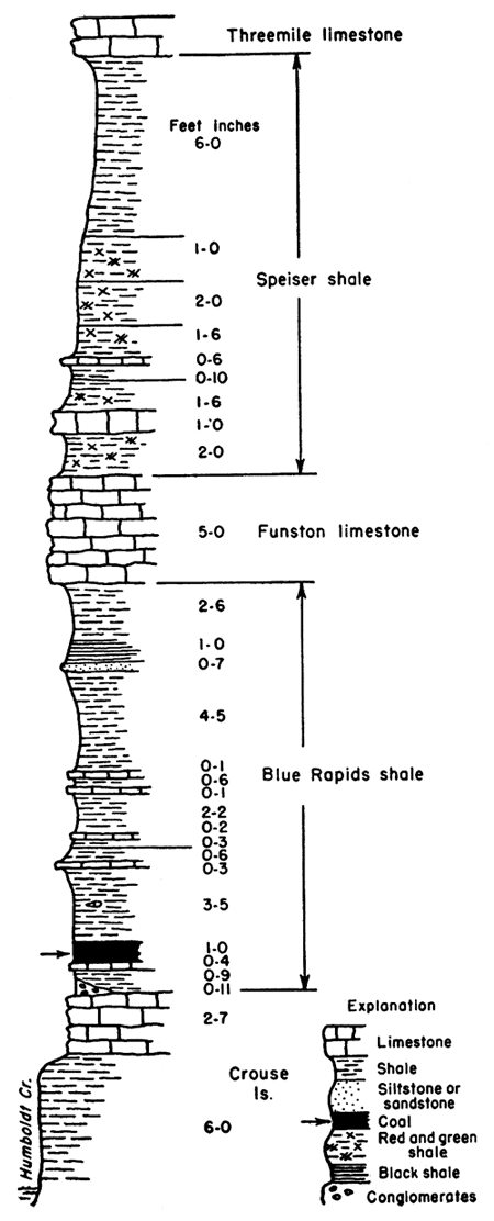
Stratigraphic position of the coal--The coal is definitely Permian in age. It occurs in the lowermost 3 feet of the Blue Rapids shale formation in the upper part of the Council Grove group. A detailed section measured by Jewett and me at the coal outcrop is presented in Figure 3. This coal, as well as a second seam close by, was recognized by Hay (1893, p. 8) as early as 1893. Hay, however, was uncertain about its age, designating the part of the section containing the coal as Permo-Carboniferous.
Figure 3--Stratigraphic section measured at the Humboldt Creek coal mine in the W2 NW sec. 17, T. 12 S., R. 7 E., Geary County, Kansas. Section measured by J. M. Jewett and W. H. Schoewe, July 8, 1949.
It is interesting to note in this connection that as early as 1854, several years before Permian strata were known to exist in Kansas or explicitly identified in America, coal had been found in rocks now classified as Permian. As reported in the Leavenworth Kansas Weekly Herald of that year the coal occurred on the Blue River, 18 miles east of Pawnee (Malin, 1950, p. 85). The exact locality where the coal outcropped is not known. Pawnee, later to become the seat of territorial Kansas, was located at the eastern edge of the Fort Riley Military Reservation. Eighteen miles east would place the coal on the Blue River several miles north of present Manhattan either in Riley or Pottawatomie County.
Mining history, production, and reserves--The Geary County Permian coal has been mined for local use for many years; seemingly the coal is used currently because local residents referred to the coal mine at the time search was being made for it in 1949. Since the coal is not of commercial quality and quantity, no production for it has ever been reported or published. Production at the best is negligible. As indicated elsewhere in this report, the coal is of extremely local distribution so that calculations of reserves, both proved and potential, are unwarranted.
Detailed stratigraphic studies of the Permian strata in Kansas by staff members of the State Geological Survey of Kansas in recent years have revealed at least six horizons at which coal occurs (Jewett, 1941; Moore, Frye, and Jewett, 1944; Moore, et al., 1951; George Verville, personal communication). Unlike the coal of the Pennsylvanian System, the Permian coal deposits are for the most part very thin, discontinuous, and entirely of a local nature. The horizons at which Permian coal occurs in Kansas are listed in Table 1 and shown in Figure 4.
Figure 4--Stratigraphic column of the coal-bearing Permian section in Kansas. Since preparation of this illustration coal has been reported below the Americus limestone in Elk County.
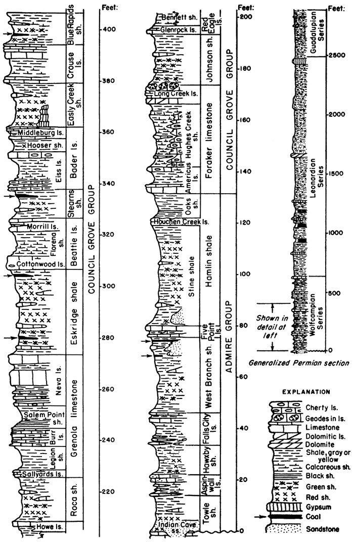
Table 1--Stratigraphic horizons at which coal occurs in the Permian of Kansas.
| Group | Formation | Coal, thickness in inches |
County |
|---|---|---|---|
| Council Grove | Blue Rapids shale | Featheredge to 12 | Geary |
| Council Grove | Oaks shale | Featheredge to 2 | Greenwood |
| Council Grove | Stearns shale | Featheredge to 6 | Lyon, Morris |
| Council Grove | Eskridge shale* | Featheredge to 12 | Brown, Chase |
| Admire | West Branch shale* | Featheredge to 34 | Chase, Elk, Greenwood, Jackson, Lyon, Wabaunsee |
| Admire | Hawxby shale | Featheredge to 1 | Riley |
| * Two coals | |||
Abernathy, G. E., Jewett, J. M., and Schoewe, W. H. (1947) Coal reserves in Kansas, Kansas Geol. Survey, Bull. 70, pt. 1, pp. 1-20, figs. 1-2. [available online]
Hay, Robert (1893) Geology and mineral resources of Kansas: State Bd. Agri., 8th Bien. Rept. for 1891-1892, World's Fair ed., pp. 1-66.
Hay, Robert (1896) The geology of the Fort Riley Military Reservation and vicinity, Kansas: U. S. Geol. Survey, Bull. 137, pp. 1-35, figs. 1-4, pls. 1-8.
Jewett, J. M. (1941) The geology of Riley and Geary Counties, Kansas: Kansas Geol. Survey, Bull. 39, pp. 1-164, figs. 1-2, pls. 1-17. [available online]
Keegan, W. P. (1932) Annual report of Coal Mine and Metal Mine Inspection and Mine Rescue Department for 1931, pp. 1-106.
Malin, J. C. (1950) Grassland historical studies, natural resources utilization in a background of science and technology: vol. 1, Geology and Geography, pp. 1-377, published privately.
Moore, R. C., Frye, J. C., and Jewett, J. M. (1944) Tabular description of outcropping rocks in Kansas: Kansas Geol. Survey, Bull. 52, pt. 4, pp. 137-212, figs. 1-9. [available online]
Moore, R.C., and others (1951) The Kansas rock column: Kansas Geol. Survey, Bull. 89, pp. 1-132, figs. 1-52. [available online]
Sherwood, J. (1926) Annual report of Coal Mine Inspection and Mine Rescue Departments for 1925, pp. 1-145.
Sherwood, J. (1929) Annual report of Coal Mine Inspection and Mine Rescue Departments for 1928, pp. 1-108.
Sherwood, J. (1930) Annual report of Coal Mine Inspection and Mine Rescue Departments for 1929, pp. 1-127.
Kansas Geological Survey, Geology
Placed on web Jan. 13, 2009; originally published in April 1951.
Comments to webadmin@kgs.ku.edu
The URL for this page is http://www.kgs.ku.edu/Publications/Bulletins/90_3/index.html