Kansas Geological Survey, Bulletin 60, Part 1, originally published in 1945
Originally published in 1945 as Kansas Geological Survey Bulletin 60, Part 1. This is, in general, the original text as published. The information has not been updated.
This report and the accompanying cross sections show the relation in the subsurface of the rocks of Simpson age in the Salina basin of central Kansas to the St. Peter sandstone and immediately overlying rocks in northeastern Kansas, southeastern Nebraska, and northwestern Missouri.
The lower part of the Simpson rocks in the Salina basin, here designated the St. Peter sandstone, consists of two sandstones separated by shaly beds. These sandstones are characterized by rounded grains and, except for the shaly parting between them, they are lithologically similar to the St. Peter sandstone of northwestern Missouri with which this part of the Simpson is correlated. The upper part of the Simpson rocks in the Salina basin, here designated the Platteville formation, consists of beds of shale, sandstone, dolomite, and limestone. It is somewhat variable in lithology because of lateral gradation, minor disconformities, or both; however, it is collectively similar to and is the correlative of rocks in northwestern Missouri called Decorah formation by Missouri geologists and probably includes also beds equivalent to the upper part of the Plattin limestone of Missouri. The Platteville formation is also the correlative of the Platteville limestone of the upper Mississippi valley.
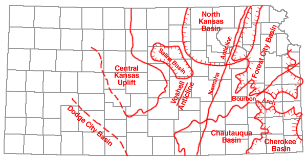
In north-central Kansas the rocks between the Viola limestone and the Arbuckle limestone are known only from well cuttings, and they have long been correlated by oil geologists with some part of the Simpson group of Oklahoma. These rocks include beds of dolomite, limestone, shale, and sandstone, whose relation to the St. Peter sandstone in northeastern Kansas and northern Missouri has been in doubt since they were encountered in wells in that part of Kansas. This paper is designed to show the relation between the Simpson rocks in the Salina basin of north-central Kansas (fig. 1) and the St. Peter sandstone and associated rocks in the Forest City basin in northeastern Kansas and adjacent parts of Nebraska and Missouri. The relation of the Simpson rocks in Kansas to the Simpson of Oklahoma is not discussed inasmuch as the present investigation has not been carried south of T. 20 S.
Fig. 1--Sketch showing principal structural features of Kansas. Chautauqua arch, indicated by pre-Chattanooga outcrops of base of Simpson sandstone (after Hugh W. McClellan); trends of Nemaha ridge fold and Voshell anticline as shown on thickness map of Mississippian limestones (Wallace Lee, Bulletin 26, Kansas Geological Survey); Salina basin, deepest part as indicated by Mississippian thickness map; Central Kansas uplift as shown by area in which Mississippian limestones are absent; Forest City and Cherokee basins from thickness map of Cherokee shale by N. W. Bass (Bulletin 23, Kansas Geological Survey); North Kansas basin of John L. Rich from thickness map of Chattanooga shale (Wallace Lee, Bulletin 33, Kansas Geological Survey); and Dodge City basin (after Hugh W. McClellan).
Neither the Forest City basin nor the Salina basin were in existence until after the deposition of Simpson rocks and their correlatives, although the North Kansas basin, the forerunner of the Salina and Forest City basins, began its development by slow differential subsidence soon after deposition of the St. Peter sandstone (Lee, 1943, p. 108). The beds (Plattin limestone) immediately overlying the St. Peter sandstone in northwestern Missouri and the upper part of the Simpson (Platteville formation) in Kansas were thus deposited in different parts of the North Kansas basin.
The stratigraphic study of the Salina basin of north-central Kansas was begun in September, 1943, under the direction of Wallace Lee, as part of a cooperative project sponsored by the Federal Geological Survey and the State Geological Survey of Kansas. Sets of samples from 122 deep wells in north-central and northeastern Kansas, northwestern Missouri, and southeastern Nebraska have been studied. The accompanying cross sections contain sample logs of 39 selected wells; only rocks of Simpson age have been plotted on them.
The Simpson group of Oklahoma, as originally defined, overlies the Arbuckle limestone (Lower Ordovician) and underlies the Viola limestone (Middle and Upper Ordovician). The relation of the rocks of Simpson age to the Viola and Arbuckle limestones is the same in central Kansas as in Oklahoma. However, in Kansas the thickness of the Simpson rocks is greatly reduced, and these rocks probably represent only a part of the Simpson group of Oklahoma where it is more than 1,500 feet thick.
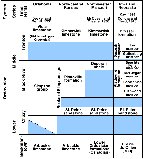
The St. Peter sandstone is exposed in eastern Missouri. It has been traced by McQueen and Greene (1938, pls. 6, 7) in the subsurface across northern Missouri into northwestern Missouri and southeastern Nebraska. In most of northwestern Missouri and in the adjacent parts of northeastern Kansas the St. Peter sandstone is overlain by beds of dolomite, limestone, and green clay shale containing minor amounts of interbedded sandstone in some wells. These rocks have been correlated by the Missouri Geological Survey with the Decorah shale of eastern Missouri. The Decorah shale of Missouri is overlain in the subsurface by rocks having typical Viola lithology which have been traced by Missouri geologists to the exposures of the Kimmswick limestone in eastern Missouri. In Nebraska, rocks lithologically similar to the Kimmswick limestone are correlated by Condra and Reed (1943, pp. 68, 69) with the Prosser limestone, the Stewartville dolomite, and the Dubuque formation of the outcrops in the upper Mississippi valley.
The Simpson interval in north-central Kansas includes two sandstones in most localities and three sandstones in some places. The accompanying cross sections show the relation of these sandstones to the St. Peter sandstone and associated beds in the region to the east where correlatives of the Simpson have not previously been identified as such.
Rocks of Simpson age are overlain by the Kimmswick limestone and underlain by the Arbuckle limestone in all but five of the wells examined. In wells no. 8 (Arkansas Fuel No. 1 Martin,, sec. 24, T. 8 S., R. 4 E.), no. 9 (Coronado No. 1 Parks, sec. 16, T. 10 S., R. 8 E.), no. 10 (Turner No. 1 Umscheid, sec. 32, T. 8 S., R. 9 E.), and no. 11 (Ohio No. 1 Lamparter, sec. 3, T. 2 S., R. 14 E.) of cross section A-A' of plate 1, the St. Peter sandstone overlies the Bonneterre dolomite of Missouri, a formation that, according to Ulrich (1932, p. 742), is slightly older than the Honey Creek limestone of Oklahoma. In well no. 12 (Arab No. 1 Ogle, sec. 9, T. 1 N., R. 14 E., Nebraska) of cross sections A-A' and C-C' the St. Peter sandstone overlies the Lamotte sandstone.
Fig. 2--Columnar section of rocks of simpson age in north-central Kansas, Oklahoma, northwestern Mossouri, Iowa, and Nebraska.
Lithology--The Kimmswick limestone in north-central and northeastern Kansas consists of beds of granular dolomite, earthy and granular limestone, and chert. The chert of the Kimmswick is characterized by minute black inclusions (at least in part pyrite), some of which are cylindrical in form. This limestone is conveniently separated into several cherty zones alternating with noncherty or only sparsely cherty zones. Four chert zones are present in the northern part of the area, where the Kimmswick is relatively thick. The first chert zone, which occurs at the top of the Kimmswick, is variable in physical characteristics and, due to erosion, is not present except in the deeper part of the North Kansas basin. The second and third chert zones below the top are easily recognized in well cuttings by physical characteristics, thickness, and constancy of intervening beds. The second zone is approximately 100 feet below the top of the Kimmswick limestone in wells nos. 12, 13, and 34 in the northern part of the area. The oldest or fourth chert zone is not present in all wells because the basal Kimmswick was not deposited in places where the formation overlapped upon topographically high areas of the eroded surface of the Simpson rocks.
Thickness--In general, the Kimmswick limestone thickens irregularly toward the center of the North Kansas basin. Thus, in well no. 9 (Coronado No. 1 Parks, sec. 16, T. 10 S., R. 8 E.), the well farthest south on cross section A-A', it has a thickness of 117 feet; in wells no. 15 (Cling Drilling Company No. 1 Bitikafer, sec. 2, T. 20 S., R. 1 W.) and no. 14 (Empire No. 1 Seible, sec. 28, T. 20 S., R. 2 E.), farthest south wells on cross section B-B', it has a thickness of 38 and 72 feet, respectively; and in well no. 39 (Pure Oil Company No. 1 Leuf, sec. 31, T. 14 S., R. 19 E.), farthest south well on cross section C-C', it has a thickness of 102 feet. Toward the north the Kimmswick limestone increases in thickness to 255 feet in well no. 13 (Jackson and Rust No. 1 June Hayes, sec. 22, T. 66 N., R. 42 W., Missouri), farthest north well on cross sections A-A' and C-C'; and to 260 feet in well no. 34 (Harry Ebke No. 1 Mathies, sec. 22, T. 5 N., R. 1 W., Nebraska), farthest north well on cross section B-B'. The greatest observed thickness (320 feet) is in well no. 32 (Westfield Oil and Gas No. 1 Canfil, sec. 16, T. 2 S., R. 1 E.) on cross section B-B'.
Stratigraphic relations--The Kimmswick limestone at exposures in eastern Missouri unconformably underlies either the Maquoketa shale or the Fernvale limestone (Richmond) and unconformably overlies the Decorah shale of Missouri nomenclature (Weller and St. Clair, 1928, pp. 113-115, fig. 2), which Kay (1935, p. 289) correlated with the upper part of the Platteville formation of the upper Mississippi valley. In Iowa this interval includes, in ascending sequence, the Prosser limestone, the Stewartville dolomite, and the Dubuque formation. However, the upper part of the sequence in Iowa is probably not represented in the Kimmswick in Missouri. Condra and Reed (1943, pp. 67-69, fig. 24) have used the Iowa nomenclature in describing rocks in the subsurface of Nebraska. Rocks having similar lithologic characteristics in exposures in south-central Oklahoma were called Viola limestone by J. A. Taff (1902). Inasmuch as subsurface studies have advanced from Oklahoma into Kansas, most oil geologists prefer the term Viola limestone; but Kimmswick is here used because the exposures in Missouri are nearer to the area under discussion than are the outcrops in either Iowa or Oklahoma.
Lithology--The St. Peter sandstone, the lower unit of the Simpson interval, overlaps upon the surface of the Arbuckle limestone and is in contact at various places with different formations of the Arbuckle. As represented in the cuttings from wells, the Arbuckle limestone consists mainly of cherty, sucrose, and granular dolomite.
Thickness--The thickness of the rocks between the base of the St. Peter sandstone and the top of the pre-Cambrian granite varies greatly from place to place. The thickness of these rocks is locally more than 1,000 feet in northwestern Missouri, but it decreases toward the west where, in places in southeastern Nebraska and northeastern Kansas, the St. Peter overlies the lower part of the Bonneterre dolomite or the Lamotte sandstone. Most of the wells utilized in the cross sections were still in the Arbuckle when drilling ceased. The thickness of the Arbuckle in most wells is, therefore, not known.
Stratigraphic relations--The Arbuckle limestone unconformably underlies the Simpson group in most of Oklahoma. The Arbuckle of Oklahoma is the correlative of the Cambrian and Ordovician rocks in Missouri that have been separated into the following formations, listed in descending sequence: Smithville, Powell, Cotter, Jefferson City, Roubidoux, Gasconade, Van Buren, Proctor, Eminence, and Potosi. The underlying Doe Run, Derby, Davis, and Bonneterre formations lie in conformable sequence above the Lamotte sandstone.
The Davis formation of Missouri was correlated by Ulrich (1932) with the Honey Creek limestone of Oklahoma which he had previously excluded from the Arbuckle (Ulrich, 1911, pp. 624, 642, 661, 666, pl. 27). Therefore, the Davis formation and the conformably underlying Bonneterre dolomite of Missouri also must be excluded from the Arbuckle. The Lamotte sandstone of Missouri and the Reagan sandstone of Oklahoma are correlatives, and they underlie the Bonneterre dolomite and the Honey Creek limestone in their respective areas. In northeastern Kansas the Arbuckle rocks were broadly arched and beveled before deposition of the St. Peter sandstone, so that in this area the St. Peter overlies various formations of the Arbuckle and locally rests on the Bonneterre and even on pre-Cambrian granite (Lee, 1943, pp. 27, 30, figs. 5, 9).
Rocks of Simpson age in north-central Kansas may be conveniently divided into two parts. The St. Peter sandstone, the lower part of the interval, is somewhat variable in character and thickness but is composed predominantly of sandstone in most wells. It is not as uniform in character in north-central Kansas as it is farther east. The Platteville formation, the upper part of the Simpson, consists of beds of shale, dolomite, limestone, sandstone, and sandy shale in variable sequence. These beds occupy the same interval as rocks in northern Missouri described as the Decorah formation by Missouri geologists. The wells are correlated on a persistent dolomite bed separating these two parts of the Simpson rocks.
McQueen and Greene (1938, pls. 6, 7) have traced the St. Peter sandstone from outcrops along the Mississippi river in eastern Missouri through a series of wells across northern Missouri to wells in northwestern Missouri, among wl-iich is the McCain No. 1 Bermond well in Buchanan County (sec. 26, T. 58 N., R. 34 W.). The lithologic character and stratigraphic relations of the St. Peter in these cross sections leave no reason to doubt the continuity of the St. Peter in the subsurface with that of the eastern Missouri outcrops. I have traced the St. Peter sandstone from the Bermond and other wells in northwestern Missouri through well no. 13 of cross sections A-A' and C-C' to other wells in the cross sections, and thence into the area in which rocks of Simpson age have been identified in north-central Kansas.
Lithology--The St. Peter sandstone in north-central Kansas consists of three zones: an upper and lower zone of sandstone characterized by rounded and frosted grains, and a middle zone composed of green clay shale containing varying amounts of imbedded sand grains, interbedded sandstone and shale, or sandstone consisting of finer and less rounded grains than that of the upper and lower zones. The middle zone is also characterized locally by disseminated grains of glauconite. This shaly zone is described by Dake (1921, pp. 24, 86, 99) in wells in Minnesota, Illinois, and Missouri. Red and brown shale and red and brown pseudo-oölitic ironstone pellets are found in the middle zone where this zone overlaps upon the Arbuckle limestone, as shown in wells nos. 2 and 11 on cross section A-A' and nos. 19, 21, 25, and 28 on cross section B-B'. This is undoubtedly the red zone described by Dake (1921, pp. 68, 85, 128) at the base of the St. Peter sandstone in certain wells in Minnesota and Illinois and in some exposures in Missouri.
The usual thickness of the upper zone is 15 to 45 feet, of the middle zone 10 to 30 feet, and of the lower zone 15 to 50 feet. Where only one sand zone composed of rounded grains is present, it is impossible to determine definitely from the cuttings whether this sandstone represents the upper or lower zone, as in wells nos. 7, 9, and 10 on cross secl-lion A-A', wells nos. 17, 22, 27, 7, 30, 32, and 33 on cross sections B-B", and all the wells in the Forest City basin.
The St. Peter sandstone in the Forest City basin area of northeastern Kansas (cross section C-C') is composed of sandstone characterized by rounded grains, and the middle zone of the St. Peter of the Salina basin does not seem to be present. In some wells in the Forest City basin area, however, there is a minor amount of green shale in the middle part of the St. Peter. Its occurrence suggests that in most wells in northeastern Kansas and northern Missouri both the upper and lower sandstone zones of the St. Peter sandstone are present and come together without the intervening middle zone of north-central Kansas.
Thickness--As a consequence of the unconformable relations at its top and bottom, the St. Peter sandstone has an irregular thickness, ranging from 10 to 84 feet as shown in the cross sections. However, greater thicknesses are known in some places within the area. The St. Peter is notably thin in wells nos. 2, 3, 4, 5, 9, and 10 on cross section A-A'. Wells in which the St. Peter is thick are no. 12 on cross section A-A'; nos. 14, 15, 16, 18, and 34 on cross section B-B'; and nos. 12, 36, 37, 38, and 39 on cross section C-C'.
Stratigraphic relations--In north-central Kansas the post-St. Peter part of the Simpson rocks is in contact with either the upper or middle zones of the St. Peter sandstone in different wells and possibly with the lower zone in some wells. This relation indicates an unconformity between the St. Peter and the overlying beds. The Arbuckle limestone in this part of Kansas is overlain directly by the lower zone or by the middle zone and perhaps in some wells only by the upper zone of the St. Peter. This relation is the subsurface expression of the locally channeled surface of the Arbuckle limestone upon which the St. Peter was deposited. An extreme expression of the basal unconformity occurs in the Kasper No. 1 James well (sec. 8, T. 13 S., R. 25 E., Johnson County, Kansas), where 403 feet of St. Peter was deposited in what seems to have been a sinkhole. The upper and lower sandstone zones are missing in wells nos. 2, 3, and 4 on cross section A-A' in the Central Kansas uplift because of erosion at the top and overlap at the bottom.
At the base of the Platteville formation in north-central Kansas there is a very persistent bed of dolomite. This bed is universally present in that part of the state and at least as far east as northwestern Missouri. Its base provides the stratigraphic plane for correlating the sample logs of the cross sections. The bed is composed mainly of sucrose or granular dolomite, but in some wells it is interbedded with earthy limestone of lithographic texture. In a few wells this bed includes minor amounts of imbedded rounded grains of sand and interbedded green clay shale. The thickness of the basal dolomite ranges from 5 to 35 feet.
Lithology--In most of the wells in north-central Kansas the Platteville above the basal dolomite is composed mainly of green clay shale and minor amounts of interbedded limestone, dolomite, and sandstone. A bed composed of rounded sand grains and minor amounts of interbedded green clay shale, 15 to 20 feet thick, is present immediately above the basal dolomite in wells no. 9 (Coronado No. 1 Parks, sec. 16, T. 10 S., R. 8 E.) and no. 10 (Turner No. 1 Umscheid, sec. 32, T. 8 S., R. 9 E.). In most of the wells south and west of these two wells, this sandstone bed changes laterally to sandy green clay shale with a bed of sandstone approximately 5 feet thick immediately above the basal dolomite datum bed. Toward the west and north this sandstone bed changes laterally to green clay shale.
In northeastern Kansas and adjacent parts of Missouri and Nebraska, the Platteville or equivalent rocks immediately above the basal dolomite bed are composed of interbedded coarsely granular and earthy limestone, sucrose and granular dolomite, and green clay shale containing minor amounts of interbedded sandstone and red shale. A bed of sandstone composed of rounded sand grains and small amounts of interbedded green clay shale is present at the top of the Platteville in well no. 12 (Arab No. 1 Ogle, sec. 9, T. 1 N., R. 14 E., Nebraska). This bed has increased in thickness to 20 feet in well no. 35 (Carter No. 4 Stratigraphic Test, sec. 24, T. 4 S., R. 16 E., Kansas) and is represented by sandy shale having thin beds of sand at the top and base. This bed and some of the underlying rocks were cut out toward the south, as shown in cross section C-C'.
Thickness--The Platteville formation in the area under discussion is as much as 104 feet thick, but toward the southeast it was entirely removed by pre-Kimmswick erosion as shown in cross section C-C'. The thickness of the formation increases somewhat irregularly toward the deepest part of the North Kansas basin.
Stratigraphic relations--The Platteville formation is unconformable below the Kimmswick limestone. As shown in cross section C-C', the Kimmswick overlies 104 feet of Platteville in well no. 12, but is in contact with the St. Peter sandstone in wells no. 38 (Huber No. 1 Community, sec. 33, T. 12 S., R. 20 E.) and no. 39 (Pure No. 1 Leuf, sec. 31, T. 14 S., R. 19 E.).
The unconformity that occurs between the Platteville formation and the St. Peter sandstone is revealed in the cross sections by the contact of the persistent dolomite bed at the base of the Platteville with the upper and middle zones of the St. Peter in north-central Kansas. This somewhat inconspicuous unconformity is the local expression of an important time interval during which more than 900 feet of rocks were deposited in southeastern Missouri between the Kimmswick limestone and the St. Peter sandstone. The formations present in southeastern Missouri are, in descending order, the Decorah shale, the Plattin and Stones River limestones, the Joachim dolomite,, and the Dutchtown formation. Most of these formations are separated from each other by unconformities and wedge out toward the northwest. Only the Decorah shale has been traced into northwestern Missouri (McQueen and Greene, 1938, pl. 7).
The correlation of the rocks that lie between the Kimmswick limestone and the Plattin limestone in Missouri is in conflict with the correlation of the rocks that lie between the Prosser limestone and the Platteville limestone in the upper Mississippi valley. The Decorah shale of Missouri, which is equivalent to the upper part of the Platteville of north-central Kansas, is not believed by Kay to be synchronous with his Decorah formation of the upper Mississippi valley. In the upper Mississippi valley the formations lying between the Prosser limestone and the St. Peter sandstone, as listed by Kay (1935, p. 295, fig. 211), are, in descending sequence, the Decorah and the Platteville. The Decorah formation of Kay is separated into the Ion member and the Guttenberg member, and is unconformable upon the Platteville. The members of the Platteville are, in descending sequence, the Spechts Ferry, the McGregor, the Pecatonica, and the Glenwood. According to Kay (1935, p. 288):
The so-called "Decorah shale" of Missouri is synchronous with the Spechts Ferry member of the Platteville, and at least the upper part of the subjacent Plattin limestone seems equivalent to the underlying (McGregor and Pecatonica) members of the Platteville of the Upper Mississippi Valley.
The Nebraska Geological Survey (Condra and Reed, 1943, p. 69, fig. 24) applies the upper Mississippi valley nomenclature to the subsurface rocks of southeastern Nebraska, and has identified Kay's subdivisions of the Platteville in some wells.
The sequence of beds in the Platteville formation in north-central Kansas is more argillaceous and sandy than equivalent beds in southeastern Nebraska. It has not been possible, in consequence, to differentiate the several members of the Platteville formation in Kansas with any degree of confidence. It is possible, also, that the confusion of stratification in central Kansas may be the result of minor disconformities within this part of the section as well as of lateral gradation. The Guttenberg and Ion members of the Decorah formation as it was described originally from exposures in the upper Mississippi valley were separated from the Platteville mainly by faunal criteria. If these members are present in the subsurface of Kansas, they are included in the Platteville formation.
Barwick, J. H., 1928, The Salina basin of north-central Kansas: Am. Assoc. Petroleum Geologists Bull., vol. 12, no. 2, pp. 177-199, figs. 1-5.
Bass, N. W., 1936, Origin of the shoestring sands of Greenwood and Butler counties, Kansas: Kansas Geol. Survey, Bull. 23, pp. 1-135, figs. 1-10, pls. 1-21. [available online]
Condra, G. E., and Reed, E. C., 1943, The geological section of Nebraska: Nebraska Geol. Survey, Bull. 14, pp. 1-82, figs. 1-25.
Dake, C. L., 1921, The problem of the St. Peter sandstone: Missouri School of Mines and Metallurgy, Bull., Tech. ser., vol. 6, no. 1, pp. 1-225, pls. 1-30.
Decker, C.E., and Merritt, C.A., 1931, The stratigraphy and physical characteristics of the Simpson group: Oklahoma Geological Survey, Bull. 55, p. 16.
Edson, F. C., 1929, Pre-Mississippian sediments in central Kansas: Am. Assoc. Petroleum Geologists Bull., vol. 13, no. 5,.pp. 441-458, fig. 1.
Kay, G. M., 1935, Ordovician system in the upper Mississippi valley: Kansas Geol. Soc., Guidebook 9th Ann. Field Conf., pp. 281-295, fig. 1.
Koester, E. A., 1935, Geology of Central Kansas uplift: Am. Assoc. Petroleum Geologists Bull., vol. 19, no. 10, pp. 1405-1426, figs. 1-5.
Lee, Wallace, 1939, Relation of thickness of Mississippian limestones in central and eastern Kansas to oil and gas deposits: Kansas Geol. Survey, Bull. 26, pp. 1-42, figs. 1-4, pls. 1-3. [available online]
Lee, Wallace, 1940, Subsurface Mississippian rocks of Kansas: Kansas Geol. Survey, Bull. 33, pp. 1-114, figs. 1-4, pls. 1-10. [available online]
Lee, Wallace, 1943, The stratigraphy and structural development of the Forest City basin in Kansas: Kansas Geol. Survey, Bull. 51, pp. 1-142, figs. 1-22. [available online]
McClellan, H. W., 1930, Subsurface distribution of pre-Mississippian rocks of Kansas and Oklahoma: Am. Assoc. Petroleum Geologists Bull., vol. 14, no. 12, pp. 1535-1556, figs. 1-3.
McQueen, H. S., and Greene, F. C., 1938, The geology of northwestern Missouri: Missouri Geol. Survey, 2d ser., vol. 25, pp. 1-217, figs. 1-11, pls. 1-7.
Ockerman, J. W., 1935, Subsurface studies in northeastern Kansas: Kansas Geol. Survey, Bull. 20, pp. 1-78, figs. 1-4, pls. 1-13. [available online]
Taff, J. A., 1902, Description of the Atoka quadrangle [Ind. Terr.]: U.S. Geol. Survey, Geologic Atlas, Atoka folio (no. 79), pp. 1-8, maps.
Ulrich, E. O., 1911, Revision of the Paleozoic system: Geol. Soc. America Bull., vol. 22, pp. 281-680, figs. 1-19, pls. 25-29.
Ulrich, E. O., 1932, Preliminary description of the Honey Creek, Fort Sill, Royer, and Signal Mountain formations of Oklahoma: Geol. Soc. America Bull., vol. 43, no. 3, pp. 742-747.
Weller, J. M., and McQueen, H. S., 1939, Composite stratigraphic section of Illinois and Missouri: Kansas Geol. Soc., Guidebook 13th Ann. Field Conf., pp. 12, 13.
Weller, Stuart, and St. Clair, Stuart, 1928, Geology of Ste. Genevieve County, Missouri: Missouri Bur. Geology and Mines, 2d ser., vol. 22, pp. 1-352, figs. 1-5, pls. 1-25.
Subsurface sections of rocks of Simpson age in north-central Kansas
Kansas Geological Survey, Geology
Placed on web July 2, 2007; originally published in June 1945.
Comments to webadmin@kgs.ku.edu
The URL for this page is http://www.kgs.ku.edu/Publications/Bulletins/60_1/index.html