![]()
Prev Page--Production || Next Page--Crystalline Rocks
Chapter VI—General Stratigraphy of Kansas
Introduction
In its broad features the geology of Kansas is almost ideally simple. The state is a very typical part of the Great Plains region, which extends from the Dakotas to Texas and from the Rocky Mountains eastward to the Mississippi, and it has the uniformly gentle slope and simplicity of geologic structure which characterize the plains. The surface of Kansas has a general inclination from west to east amounting to about ten feet per mile, the elevation of the western state boundary being about 3,500 to 4,000 feet, that of the eastern boundary from 750 to 1,000 feet. The rock formations of which this sloping plain is built lie almost flat, and are exposed in broad north-south bands across the state. In reality they sag slightly in central Kansas, the rock slope or dip being toward the west in the eastern counties and to the east in the western part of the state. The oldest beds appear at the surface in the east and dip beneath the younger overlying formations which appear in succession as the state is crossed to the west (see Plate XII).
Formation of the Rocks of Kansas
The rocks of Kansas, as classified on the basis of origin, belong to the sedimentary group. Rocks of igneous origin have been found in deep wells, but do not come to the surface within the borders of the state. The formation of the sedimentary rocks may be discussed briefly as an introduction to the summary of the stratigraphy of Kansas which follows.
Sedimentary rocks are those composed of the transported fragments or particles of older rocks that have undergone disintegration. The chief agencies of transportation are water—including rain, streams, lakes and the sea—wind, and glaciers. Deposition of the rock particles may take place along streams, at the bottom of lakes or the sea, where the wind drops its load, or beneath glaciers. Materials such as gravel, sand and clay are carried as solid particles, and after deposition may be consolidated to form conglomerate, sandstone or shale. Other materials are carried in solution and may be deposited chemically, as in the formation of salt or gypsum, or by the action of plants or animals, as in the formation of limestone or coal. Sedimentary rocks are usually made up of layers or beds called strata which can easily be separated.
By far the most important area of deposition in which sedimentary rocks are being formed is the bottom of the ocean. The bottom of the sea is covered with gravel, sand and mud, which are sorted and spread by the waves and currents. As these sediments gather they bury others already deposited. When compressed by the weight of overlying materials, and bound together by cement deposited between the grains, the originally unconsolidated sediments are hardened into firm rock.
The materials composing the stratified rocks vary with the locality, for the conditions of their deposition at different times and places have not been alike, and accordingly the rocks show many variations. Where beds of sand were buried beneath beds of mud, sandstone may now occur beneath shale. Each of these masses is limited in extent to the area over which it was deposited, and is bounded above and below by different rocks. It is convenient in geology to call such masses "formations." A sedimentary formation may contain between its upper and lower limits either rocks of uniform character or rocks more or less uniformly varying in character, as, for example, an alternation of shale and limestone. When for scientific or economic reasons it is desirable to recognize and map one or more especially developed parts of a formation, the parts are called "members."
It is evident from geologic study that during former times the sea has covered very considerable portions of the continent, carrying with it the same conditions of sedimentation as now characterize it. The surface of the earth is not immovable; over wide regions it very slowly rises or sinks with reference to the sea, and the shore lines are changed. If North America were to sink a thousand feet the sea would flow over the Atlantic coast and the Mississippi and Ohio valleys from the Gulf of Mexico to the Great Lakes. The Appalachian Mountains would become an archipelago in the ocean, whose shore would traverse Wisconsin, Kansas and Texas. More extensive changes than this have slowly but repeatedly occurred in the past, and the shores of the North American continent have changed from age to age. The sea has covered much which is now dry land. When the sea is withdrawn from the land marine sedimentary rocks become part of the land, and most of our land areas are, in fact, composed of rocks originally deposited as sediments in the sea. The sedimentary rocks are distinguished according to their relative ages, the younger beds resting on those that are older in any series of undisturbed strata.
Stratified rocks generally contain the remains of plants or animals which lived in the sea, or were washed from the lands into lakes and seas. By studying these remains or fossils it has been found that the life of each epoch of the earth's history has to a great extent differed from that of other epochs. During each geologic period there have lived peculiar forms which did not exist in earlier times and have not existed since. These are characteristic types and define the age of any bedded rock in which they are found. The study of the stratified rocks, or stratigraphy, is therefore based both on the study of the rocks themselves and upon the fossils they contain.
Based on the alternation of advance of the seas over the land, represented by deposits of marine formations, and succeeding retreats, indicated by the partial erosion of rocks formed during submergence, geologic time has been conveniently divided into unit parts of various rank, termed eras, periods, and epochs. The rocks deposited during a period are called a system, and those of an epoch, a group. Thus the Pennsylvanian system denotes the rocks laid down during the Pennsylvanian period. The erosion breaks between rock divisions are called unconformities.
The Rock Systems of Kansas. During the almost inconceivably long geologic past the Kansas region has been submerged by the sea a number of times. Between these have occurred protracted periods of erosion when-the destructive agents of air and water attacked and removed large portions of the rock strata previously formed. Investigation has shown that at the time great thicknesses of rock were being formed in other parts of North America, Kansas was a land area. The geologic record of these times is therefore missing in Kansas. On the other hand, certain geologic periods are much better represented in Kansas than in other regions. The following table indicates the rock systems of Kansas and their divisions, the oldest beds being placed as they are in nature, lowermost.
| Geologic section of the Kansas region | |||||
|---|---|---|---|---|---|
| System | Groups | Formation | Character of Rocks | ||
| Cenozoic | Quaternary | Recent | Alluvium, dune sands | ||
| Pleistocene | Wisconsin stage Kansas stage |
Glacial deposits | |||
| Unconformity | |||||
| Tertiary | Pliocene Miocene |
Ogalalla | Gravel, sand, clay | ||
| Unconformity | |||||
| Mesozoic | Cretaceous | Montana | Pierre | Shale | |
| Colorado | Niobrara Benton |
Limestone, chalk, shale | |||
| Dakota sandstone | Sandstone, shale | ||||
| Unconformity | |||||
| Comanchean | Washita | Kiowa Cheyenne |
Sandstone, shale | ||
| Unconformity | |||||
| Paleozoic | Permian | Cimarron | Greer Woodward Cave Creek Enid |
"Red beds," sandstone, shale, dolomite, gypsum, salt |
|
| Big Blue | Wellington Marion Chase Council Grove |
Shale, limestone | |||
| Pennsylvanian | Missouri | Wabaunsee Shawnee Douglas Lansing Kansas City |
Limestone, shale, sandstone | ||
| Des Moines | Marmaton Cherokee |
Limestone, shale, sandstone | |||
| Unconformity | |||||
| Mississippian | Chester | ||||
| Unconformity | |||||
| Osage | Warsaw Keokuk Burlington Pierson |
Limestone | |||
| Not exposed in Kansas |
Paleozoic | Kinderhook | Limestone, shale | ||
| Unconformity | |||||
| Ordovician | Joachim Jefferson City Roubidoux |
Dolomite, sandstone, shale | |||
| Unconformity | |||||
| Cambrian | Gasconade Proctor Eminence Potosi |
||||
| Unconformity | |||||
| Pre-Cambrian | |||||
Plate XI—Map showing the geology of Kansas and the adjoining region. (After Bailey Willis, U.S.G.S.) A larger Acrobat PDF version of this figure is available.
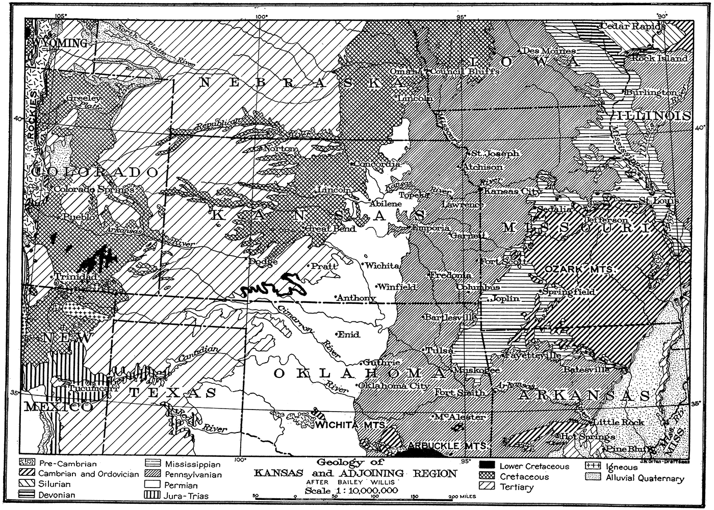
The oil and gas deposits of the Midcontinent field are confined almost wholly to rocks of the Pennsylvanian system, which outcrop in a broad belt across eastern Kansas and Oklahoma (see geologic map, Plate XI). In other districts oil and gas in commercial quantities occur in strata of geologic divisions as old as the Ordovician, but they have not yet been found in the older rocks of the Midcontinent field. A test well now being drilled in a very well-defined dome north of Dougherty, Okla., starts in graptolite-bearing Ordovician limestone, and should settle the question of production from these older beds. [Note: Powers, Sidney, Personal communication. Report has more recently been made of the undoubted occurrence of oil in rocks of Ordovician age in the Healdton field, southern Oklahoma.] It is known that in a number of localities, chiefly in Oklahoma, there are important oil and gas pools within the Mississippian. Oil and gas have been found also in the Permian and in the Cretaceous, although it is possible that the oil and gas have in these strata migrated upward from underlying Pennsylvanian formations. On account of the broader distribution of oil and gas which is thus indicated, and because exploration for these hydrocarbons is being carried much beyond the limits of the Pennsylvanian outcrops, it seems desirable in this report to eon sider briefly the general stratigraphy and the oil and gas prospects of the whole state so far as they are now known.
Older Rocks of the Midcontinent Region
Pre-Cambrian
The rocks in the general region of the Midcontinent field range in geologic age from almost the oldest known to the youngest. The oldest rocks are granites and other crystalline rocks of probable Archeozoic age which are exposed in the southeastern part of Missouri, in the Arbuckle and Wichita mountains of Oklahoma, in the Rocky Mountains of Colorado, and at points farther distant north of Kansas (Fig. 24). Since the exact age of these isolated patches of very ancient rocks is difficult or impossible to determine, it is most convenient to speak of them simply as Pre-Cambrian, for in all cases they are known to be older than the first sedimentary rocks of the Paleozoic. It is known that the Pre-Cambrian rocks extend for great distances beneath the surrounding sedimentary formations, since they have been encountered in deep wells at many points outside the area of their outcrop. Geologic study indicates that any well drilled to a sufficient depth should strike the Pre-Cambrian; that is, that these crystalline rocks represent a "fundamental basement" or floor on which all the succeeding stratified rocks of the continent are laid down. According to abundant observation in all parts of the world, the Pre-Cambrian marks the lower limit of possible oil and gas deposits.
The Pre-Cambrian nowhere appears at the surface in Kansas, but recent exploration for oil and gas in the central part of the state suggests that it approaches the surface much more closely than was supposed. Sufficient tests have been made to indicate fairly clearly the presence of a buried ridge or mountain range of granite which appears to trend in a direction slightly east of north from Butler county to the northern limits of the state. [Note: A detailed discussion of this granitic ridge will be found in chapter VII of this report.] No evidence of metamorphism of the sedimentary rocks immediately overlying the granite has been found, and it is probable that the ridge represents a part of the Pre-Cambrian floor.
Cambrian and Ordovician
The sedimentary formations which rest upon the Pre-Cambrian floor conform essentially to its surface. They are nearly horizontal over wide areas where the underlying crystallines have not been deformed, but are upturned where the granite has been pushed more or less sharply upward by deep-seated mountain-making forces. Thus where the granites appear at the surface in Missouri, Oklahoma, Colorado or Dakota, the oldest sedimentary rocks are upturned around them, the younger formations appearing in the order of their age farther away (Plate XII). The exposure of these lower Paleozoic formations, even at a distance from Kansas, makes possible a more accurate conception of their character within the state than would be obtained from the record of deep borings alone.
As studied in the Ozark region of Missouri, the rocks beneath the Mississippian and overlying the Pre-Cambrian include representatives of each of the geologic time divisions of the Paleozoic. The Cambrian and Ordovician systems of this region aggregate from 2,000 to 2,500 feet, consisting of dolomites, limestones, shales and sandstones. The succeeding Silurian and Devonian, however, are very thin and irregular in distribution and are practically confined to the northern, eastern and southern flanks of the Ozark uplift. The Silurian has been definitely recognized in northeastern Oklahoma (Taff, 1905; The Silurian is represented by the St. Clair limestone about 100 feet in thickness.) and northern Arkansas (Williams, 1900, p, 277-284), but beds of this period and of the Devonian are wanting throughout most of the region of the Great Plains. [Shepard, 1892, northern Arkansas and Oklahoma (Chattanooga shale and Sylamore sandstone), referred "to the Devonian by various writers, are probably referable rather to the basal Mississippian.] West of Kansas, in the upturned strata of the Front Range of the Rocky Mountains (Plate XII), the strata of the Great Plains are well exposed and may be studied in some detail. Here the Cambrian is observed in certain localities, but it has a thickness of not more than fifty or sixty feet and for long distances it is absent altogether. The Ordovician, similarly, while recognized here and there, has a maximum thickness of only 250 feet, and disappears north of Denver. Cambrian and Ordovician strata are present in the Wichita and Arbuckle mountains and surrounding the Black Hills of South Dakota. Since these old formations come to the surface at various points on almost all sides of Kansas, it may be supposed that they underlie most of the state, but it should be noted that their thickness decreases very greatly from east to west as shown by observations in Missouri and Colorado. Deep borings in southeastern Kansas indicate the thickness of sedimentary rocks beneath the Mississippian to be more than 2,200 feet (Iola) (Haworth and Bennett, 1908, p. 66 1/2), although granite has been reported only 1,000 feet below the Mississippian at Paola (Haworth and Bennett, 1908, p. 66 1/2) and Neodesha (Haworth and Bennett, 1908, p. 64-65) (?). If the granite of central Kansas already mentioned is Pre-Cambrian, the older Paleozoic rocks are absent in this region, for the beds which immediately overlie the granite are apparently Pennsylvanian in age.
Plate XII—Geologic cross-section in an east-west direction across the Kansas region.
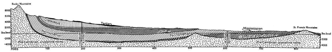
In summary, it appears that a series of dolomite, shale and sandstone formations belonging to the Cambrian and Ordovician systems, possibly with thin local deposits of Silurian or Devonian age, underlie most of Kansas. These beds are more than 2,000 feet thick in the eastern part of the state, but probably become very much thinner or locally absent to the west.
Mississippian System
Resting upon the eroded surface of the rocks of the older Paleozoic in the Great Plains country is found the Mississippian system, or, as it is called by drillers, the "Mississippi lime." The Mississippian, which is now widely and popularly known in the Midcontinent fields because of its relation to the deposits of oil and gas in the overlying formations, is a clearly defined, readily traceable stratigraphic unit, consisting chiefly of crystalline limestones containing a rather unusual amount of hard, flinty chert. In Oklahoma and northern Arkansas it includes important beds of shale and some sandstone, but where encountered by the drill in Kansas and throughout most of Missouri it is essentially a limestone series. The thickness of the system in the south central part of the Mississippi basin is more than 2,000 feet, but in Kansas it is not more than 300 or 350 feet.
As shown on the accompanying sketch map (Plate XI), the Mississippian outcrops in a band of varying width almost surrounding the area of older Paleozoic rocks in the Ozark highland. This band of outcrop extends across Missouri in an east-west direction just north of Missouri river, and swings to the south from Sedalia into the Joplin and Springfield region, where a considerable area in southwest Missouri, northeastern Oklahoma and northwestern Arkansas, is covered by Mississippian rocks. The only portion of Kansas in which the Mississippian beds occur at the surface is a very limited area in the southeastern portion of Cherokee county in the extreme southeastern corner of the state. The boundary between the Mississippian and the succeeding Pennsylvanian crosses the state line from Missouri about fifteen miles north of the southern border of the state and passes into Oklahoma about nine miles from the east Kansas state line.
The rocks of the Mississippian area in Kansas have been referred to the Burlington or Keokuk formations, but according to recent investigation by the writer there seems little doubt but that this area belongs in the succeeding Warsaw division. This is in accordance with the determination by Weller (Stuart Weller, personal communication) of a part of the Mississippian of the adjoining southwestern Missouri district. The subdivisions of the Mississippian have not been recognized in other portions of the state, although it seems probable that the limestone encountered in deep wells belongs chiefly to the Osage group. It is possible that the oil-bearing sandstones and shales of Chester age in Oklahoma extend northward a short distance' into Chautauqua county, Kansas, since wells near Sedan have recently reported oil beneath "Mississippi lime." Deep wells at various points in Kansas northwest of the Mississippian outcrops above mentioned have encountered the limestone beds of the system. They show that the beds are gradually inclined in a west or northwest direction at a rate varying from eight to fifteen or twenty feet per mile (see Plate XXV).
The Mississippian has been recognized at points as far west as Douglass (3,110 feet depth), but to what distance farther west the limestones of this age extend cannot be stated on evidence at hand. It is apparently absent along the line in which the wells have encountered the granite ridge in the east-central portion of the state. Mississippian limestone has not been encountered at any point in the drillings west of this ridge, although it is quite possible that it is present in certain areas. The Mississippian appears at the surface locally where the rocks of the Paleozoic are upturned along the flanks of the Front Range in Colorado.
The upper surface of the Mississippian limestone is very uneven, having been greatly eroded during pre-Pennsylvanian time. As indicated by well drillings and observations in southeastern Kansas, the top of the Mississippian has a variation in elevation of as much as 75 or 90 feet in distances of less than one-half mile. This evidence of erosion has been observed throughout the Mississippi basin, and has been described by many geologists. It should be noted, however, that although there is considerable irregularity in the surface of the Mississippian limestone within a limited district, observations over a wider area show a general conformity between the bedding of the Mississippian and that of the overlying Pennsylvanian. This indicates that notwithstanding the widespread and possibly long-continued erosion after the Mississippian, there was no important disturbance of the older beds before Pennsylvanian deposition. (See structure contour map Plate XXV.)
Pennsylvanian System
General Description
The Pennsylvanian system as observed in Kansas consists of a thick series of alternating shale and limestone formations, with irregular beds of sandstone and some beds of coal.
Distribution. Pennsylvanian strata appear at the surface in a broad belt extending from northern Iowa to Texas, all of northwestern Missouri, southeastern Nebraska, the eastern one-fourth of Kansas and a large portion of Oklahoma and Arkansas being composed of these rocks (Plate XI). The Pennsylvanian of the Midcontinent region was at one time without doubt continuous with the beds of the same age in Illinois and states farther east, and is possibly directly continuous with the Pennsylvanian formations which come to the surface in the Front Range of the Rocky Mountains in Colorado. The system is of greatest economic importance because of the oil and gas contained in many of its more porous formations, and because of its deposits of coal, shale, clay and limestone.
Thickness. The Pennsylvanian rocks of Kansas have a thickness, according to Haworth (Haworth and Bennett, 1908, p. 73) of nearly 3,500 feet in the southern part of the state and a slightly smaller amount to the north. A total thickness of about 3,000 feet has been measured along Kansas river. As the Pennsylvanian rocks have a general dip to the west they are consequently much thinner along the eastern border of their outcrop, where only the older formations have been spared by erosion, and thickest in the counties adjoining the belt of Permian outcrop. Since the dip of the beds is low and the relief of the surface slight outcrops of the lower formations are separated by a distance of more than 100 miles from those of the upper. Accordingly, measurement of the thickness of the lower formations at their outcrop does not indicate precisely their thickness at points a considerable distance to the west and compilation of surface measurements does not show accurately the total thickness of the system. However, the record of deep wells indicates that the figures given are approximately correct.
Lithologic Character. The Pennsylvanian system is composed of a number of varieties of shale, sandstone, limestone, clay and coal, which, though rather thin in a vertical direction, are unusually persistent horizontally. Many of the limestones have been traced from the north to the south border of the state and in some cases a considerable distance into adjoining states. This persistence of the Pennsylvanian beds has made the detailed studies of Haworth, Bennett, Adams, Beede and others of great value and wide application, and we now have an excellent general knowledge of the stratigraphy of eastern Kansas.
From a quantitative standpoint, the shales are the most important of the rocks of the Pennsylvanian, constituting a considerable proportion of almost every formation. The shales are in general rather argillaceous. In many cases, however, they are quite sandy, and at many horizons grade both laterally and vertically into sandstone. Some of the shales are highly calcareous, in places containing so much lime that they might rather be called shaly limestones. The general color of the Pennsylvanian shale is gray or yellowish brown, but variegated tints of other colors are not uncommon. Dark or black slaty shales with abundant carbonaceous or bitumious matter also occur.
The limestones are probably next in importance in the Pennsylvanian of the region. They are, for the greater part, light-colored fossiliferous, fine-grained, compact rocks, many of the beds, especially the thicker ones, being also quite cherty. Some are oolitic and thick-bedded. The fragments of fossils of various sorts are extremely abundant in many formations, and in certain cases make up almost the entire body of the rocks. These include the more or less recognizable fragments of bryozoans, corals, shells of brachiopods and other invertebrates.
Sandstone is abundant at certain horizons, but, quantitatively considered, it is less important than the foregoing rock types. As a rule the sandstones are of medium grain and contain a great deal of mica. In a few instances they are coarse grained and non-micaceous. In color they vary from white to blue-gray or yellow, but in almost all cases they weather to a yellowish brown. The sandstone formations are not very persistent horizontally, grading laterally as well as vertically into shales of more or less impervious character. The sandstones have a very great economic importance because of their content of oil and gas at very many places. Coal is important in the lower divisions of the Pennsylvanian in Kansas; especially in the southeastern portion of the state. The coal beds of the Cherokee shale and of the overlying Marmaton formation are the most valuable. Clays are common in certain areas. They occur especially near the base of the Pennsylvanian associated with beds of coal.
Effect of Topography. The lithologic character and the structure of the Pennsylvanian rocks of eastern Kansas are very closely reflected in the topography and physiography of the region. The limestone formations characteristically form more or less well-defined escarpments with steep eastern slopes, and very long, gentle dip slopes to the west, which are traceable in some instances for miles (Plate XIX). The escarpments made by the outcrops of these resistant formations may be followed with the greatest ease from one border of the state to the other, and have been mapped in some detail by Haworth and Bennett (1908, plates VIIa, VIIb, VIIc). The outcropping lines of the different formations are shown in the geologic map, Plate I. Geologic cross-sections drawn in various directions across the state have been prepared with considerable care by Haworth (1898a, plates VIII-XIII). A study of them will show the general relation of the formation to each other and to the surface outcrops (see Plates XVII-XIX).
Structure. In common with the Mississippian and other systems outcropping in eastern Kansas and the adjoining region, the Pennsylvanian strata have a gentle inclination outward from the Ozark highlands. In northeastern Kansas they dip toward the northwest, in central eastern Kansas almost due west, and in the southern counties of the state slightly southwest. If the Pennsylvanian is continuous beneath the thick overlying formations of Permian, Cretaceous and Tertiary age in the western part of Kansas, the system is a part of the shallow sag or syncline which characterizes the broader structure of the state. However, when examined in detail it is seen that there are many irregularities in the structure of the Pennsylvanian rocks. For example, at many points in eastern Kansas the rock strata are absolutely horizontal, or are even inclined to the east. [Note: A typical anticline may be cited in the vicinity of Alma, Wabaunsee county, in which there is an east dip of 160 feet in six miles. In the Cushing district, the most important of all the Oklahoma pools, there is a vertical distance of only 160 feet from the top of the dome to the bottom of the adjacent syncline.] These irregularities are minor waves on the major structure of the Pennsylvanian, and though not prominent, they are of the very greatest importance to the oil producer, for they control in a very essential way the distribution of the oil and gas in the rocks. They are the anticlines sought for by the geologist.
Subdivisions. On the basis of difference in lithologic character and fossils, and to a certain extent on the evidence of erosion breaks at places in the series, the rock strata of the Pennsylvanian have been divided into a number of formations and members. The names used in this report are those which appear to accord most closely with the established rules of priority in the nomenclature of geologic formations, and are, with very few exceptions, the names which have been recommended by the Committee on Geologic Names of the United States Geological Survey (Hinds and Greene, 1915, p. 16). A considerable amount of geologic work has been done in the region where the Pennsylvanian outcrops, and the subdivisions which have been recognized have been traced across most of the state. They may be accepted, therefore, as well-defined stratigraphic units.
| Divisions of the Pennsylvanian rocks of Kansas | ||
|---|---|---|
| Group | Formation | Member |
| Missouri | Wabaunsee formation | Eskridge shale |
| Neva limestone | ||
| Elmdale shale | ||
| Americus limestone | ||
| Admire shale | ||
| Emporia limestone | ||
| Willard shale | ||
| Burlingame limestone | ||
| Shawnee formation | Scranton shale | |
| Howard limestone | ||
| Severy shale | ||
| Topeka limestone | ||
| Calhoun shale | ||
| Deer Creek limestone | ||
| Tecumseh shale | ||
| Lecompton limestone | ||
| Kanwaka shale | ||
| Douglas formation | Oread limestone | |
| Lawrence shale | ||
| Iatan limestone | ||
| Weston shale | ||
| Lansing formation | Stanton limestone | |
| Vilas shale | ||
| Plattsburg limestone | ||
| Lane shale | ||
| Kansas City formation | Iola limestone | |
| Chanute shale | ||
| Drum limestone | ||
| Cherryvale shale | ||
| Winterset limestone | ||
| Galesburg shale | ||
| Bethany Falls limestone | ||
| Ladore shale | ||
| Hertha limestone | ||
| Des Moines | Marmaton formation | Pleasanton shale |
| Coffeyville limestone | ||
| Walnut shale | ||
| Altamont limestone | ||
| Bandera shale | ||
| Pawnee limestone | ||
| Labette shale | ||
| Fort Scott limestone | ||
| Cherokee shale | Undifferentiated | |
In the development of our present knowledge of Pennsylvanian stratigraphy in Kansas, these beds have been subdivided into various groups and formations which do I,Ot accord with present classification. Many geologic names have been used, and a good deal of confusion has followed the different definitions and use of geologic names by various workers. In order to show the development of the stratigraphic classification adopted in this report, and to indicate its relation to the names which have previously been used, the accompanying table has been prepared. Reference to this summary of classification will obviate the necessity of recounting the usage of various authors in the definition and description of the stratigraphic units.
The general stratigraphy of the subdivisions of the Pennsylvanian will be discussed briefly. The descriptions must, however, be regarded as a mere summary of Kansas geology adapted to the use of those especially interested in the development of oil and gas. The discussion of stratigraphic problems of purely scientific interest and matters not germane to the subject of this report are purposely omitted.
Des Moines Group
[Note: Keyes, 1893, pp. 85-114; Named from Des Moines, Iowa.]
The Pennsylvanian system of the western Mississippi valley has been divided into two main groups, the lower termed the Des Moines group and the upper the Missouri group. These divisions, which are identical with the "Lower" and "Upper Coal Measures," respectively, of earlier geologists, were originally made in the belief that the higher, younger portion of the Pennsylvanian was differentiated from the lower part by a much greater proportion of calcareous matter. This is in truth a generally distinguishing feature, but detailed studies over a wide area have shown that limestones are more abundant in the Des Moines group than first supposed, and that shale and sandstone are almost if not quite as important in the Missouri group as in the Des Moines. Lithologic differences are therefore not so sharply defined. However, a well-marked faunal change occurs at the line of division between the two groups, and in Missouri there is evidence of an erosion break of wide extent at about the same horizon. The major classification of the Pennsylvanian indicated may be accepted, therefore, in this report. It is to be hoped that additional paleontologic study will make possible a subdivision of the Pennsylvanian of the western Mississippi basin into groups which are at least approximately correlative with those defined in the Appalachian region.
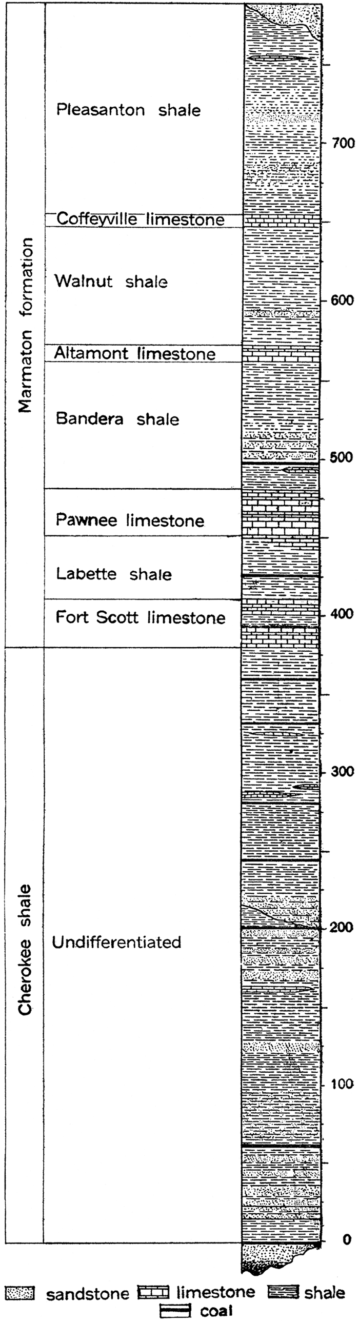
The Des Moines group includes approximately 500 to 800 feet of the lower strata of the Pennsylvanian of Kansas. It consists chiefly of clastic materials such as shale and sandstone, but contains an important minor content of limestone (Fig. 14). Deposits of coal and clay of great economic value also occur. The porous sandstones of the Des Moines are the chief containers of the oil and gas deposits of Kansas and Oklahoma.
Figure 14—Generalized section of the Des Moines group of the Pennsylvanian in Kansas.
Rocks of the Des Moines group outcrop in an irregular band surrounding the older beds. They occupy the southeastern portion of Kansas, extending from Miami county on the northeast to Montgomery county on the southwest, including all or portions of Linn, Bourbon, Crawford, Neosho, Cherokee and Labette counties. The beds of the Des Moines dip to the west and northwest and are continued from the zone of their outcrop an unknown distance. If oil-producing horizons in the Butler county area belong to the Cherokee, the Des Moines reaches at least to the central part of the state.
Variations in the thickness of the Des Moines group are largely dependent upon changes in the character of the Cherokee shale. The total thickness of the group may be obtained by measuring its various units in the area of their outcrop. These may be supplemented by the records of deep wells, and indicate a varying thickness in different localities: at Atchison, 813 feet; Kansas City, 669 feet, etc.
The Des Moines group has been divided into two formations of approximately equal thickness, the Cherokee shale below and the Marmaton formation above. This appears to be very desirable both on lithologic and faunal grounds. The Cherokee is essentially a shale and sandstone formation, almost lacking in limestone; but beginning with the persistent limestone of the Fort Scott horizon, the Marmaton contains a number of well-defined limestone members. Distinct differences in the faunas of the two formations have been recognized by Beede and Rogers in their description of the Coal Measures fossils of Kansas (Beede and Rogers, 1908, p. 318-385).
Cherokee Shale
[Note: Haworth and Kirk, 1894, p. 105; named from Cherokee county, Kansas.]
The Cherokee shale lying at the base of the Pennsylvanian system in Kansas is especially important because it contains the more or less irregular beds of sandstone which are the chief oil and gas producers of the state (Fig. 14). The formation is exposed at the surface over most of Cherokee county, from which it takes its name, and in the eastern portions of Crawford and Bourbon counties. The belt of Cherokee extends northeastward across most of Missouri and has been traced southwest through Oklahoma as far as Arkansas river. It is possible that it extends eastward into Arkansas.
The Cherokee shale has an average thickness of 400 to 500 feet in southeastern Kansas, but there is considerable variation. At Topeka. deep drilling indicates a thickness of 704 feet, at Atchison 598 feet, at Emporia 351 feet. It appears from this that the Cherokee shale is thicker to the north and northwest, but not so thick to the west. In Oklahoma the Cherokee shale is very much thicker, aggregating more, than 1,000 feet in the vicinity of Pryor creek (Shannon and Trout, 1915, p. 84), and if correlated with the Winslow and Boggy formations farther south, a total thickness of 1,500 feet is attained.
The lithologic character of the Cherokee shale is indicated in the generalized section, Figure 14, which shows a succession of shale and sandstone, with beds of coal and discontinuous limestone layers at certain horizons. Shale constitutes by far the greatest part of the formation, although the proportion of sandstone is very important. Limestone is almost negligible in quantity. There is considerable lithologic variation, both vertically and laterally, in the Cherokee shale. The color ranges from light ash gray to yellowish brown and jet black, and there are changes in the material from finest-grained clay shale to very sandy shale and sandstone. Sandstone beds are very abundant throughout the Cherokee, but are not of sufficient persistency to be of value in stratigraphic study. They are the source of most of the production of southeastern Kansas and the adjacent portion of Oklahoma, and possibly also in the Butler county field. The Bartlesville sand is the most important of the oil and gas horizons of the Cherokee. It has been encountered throughout most of the producing field. Other oil and gas sands of the Cherokee are recognized in the description of individual districts which follow.
Marmaton Formation
[Note: Haworth, 1898a, pp. 92, 94; named from Marmaton river, eastern Kansas.]
The Marmaton formation, in striking contrast to the underlying Cherokee shale, contains a number of well-defined limestone members which have been traced the entire length of the formation outcrop across the state. Between the limestones are persistent shale members. Differentiated almost entirely on a physiographic basis (Haworth and Bennett, 1908, p. 74-75), the Marmaton formation is yet a lithologic unit and has a fauna which is sharply distinct, both from that of the underlying Cherokee and from that of the beds of the succeeding Missouri group. Since no break in sedimentation or marked change in lithologic character occurs within the formation as here defined, and since the fossils of the Marmaton are a unit, there seems to be little or no basis, so far as Kansas is concerned at least, for dividing the Marmaton into two formations as has been done in Missouri. [Hinds and Green, 1915, p. 17-22. The formations in the Missouri report corresponding to the Marmaton formation are the Henrietta formation below, and the Pleasanton formation above.]
The outcrop of the Marmaton formation appears as a broad band twenty to thirty miles wide, trending in a direction from northeast to southwest across southeastern Kansas. It is the most important surface formation in Labette, Crawford and Bourbon counties. In this district the Cherokee is buried a relatively slight depth, so that drilling operations are inexpensive.
The average thickness of the Marmaton is about 300 to 400 feet. The entire thickness is present, of course, only toward the west border of the belt of outcrop, where the upper members of the formation have not been removed by erosion. The Marmaton formation includes eight members of alternating limestone and shale.
Fort Scott limestone member. (Swallow, 1866, p. 25; named from Fort Scott, Bourbon county, Kansas.) At the base of the Marmaton is the Fort Scott limestone, comprising a lower limestone bed, 5 to 18 feet thick, a thin but persistent intermediate shale bed 7 to 8 feet thick, and an upper limestone bed 10 to 12 feet thick. The total average thickness of the member is thus about 30 feet. The Fort Scott limestone appears at the surface in a narrow band at the east edge of the Marmaton belt of outcrop, and extends from the south border of the state near Chetopa and Oswego to the east state boundary in the vicinity of Fort Scott. It forms a prominent escarpment almost the entire distance. In places the top of the limestone is marked by a long dip slope which extends miles to the west. It has been determined (Shannon and Trout, 1914, p. 86) that the Wheeler sand in the Cushing district, the Oswego sand in the Bartlesville pool, and possibly certain sands in the Glenn pool, are at the horizon of the Fort Scott limestone member.
Labette shale member. (Haworth, 1898a, p. 36; Named from Labette county, Kansas.) The Labette shale lies between the Fort Scott limestone and the succeeding Pawnee limestone, its thickness ranging from 20 to 60 feet in Kansas and to more than 120 feet in northern Oklahoma. The formation consists of clayey and sandy shales, which grade locally into somewhat shaJy sandstone.
Pawnee limestone member. (Swallow, 1866, p. 9) The Pawnee limestone is a massive, rather fine-grained limestone having an average thickness of about 45 feet where completely developed. A maximum thickness of 52 feet has been observed in Kansas (Haworth and Bennett, 1908, p. 83-84). It is exposed in a narrow zone from a point west of Chetopa to the east Kansas border in the vicinity of Fulton. The Pawnee limestone may be distinguished readily from the underlying Fort Scott limestone by its massive bedding and its large content of iron. The Pawnee limestone is distinctly less fossiliferous than the Fort Scott.
Bandera shale member. (Adams and others, 1903, p. 32; named from Bandera, Bourbon county, Kansas.) The Bandera shale is a rather thick, somewhat lenticular member, blue to black in color. It measures from 60 to 120 feet in Kansas, but according to observations in northern Oklahoma it is much thinner there. The Bandera shale outcrops in a zone three to eight miles in width, which reaches from the south part of the state in the vicinity of Altamont northeastward to the vicinity of Prescott. As a whole the shale is rather argillaceous, but there are gradations to sandy shale, shaly sandstone or pure sandstone. Quarries for flagstone are operated at various points along the outcrop. Some of the oil and gas sands of Kansas are at this horizon, and the Peru sands of the DeweyBartlesville field in Oklahoma have been referred to this member (Shannon and Trout, 1914, p. 86). Coal is locally important in the Bandera shales, being mined near Hammond.
Altamont limestone member. (Adams, 1896, p. 22; named from Altamont, Labette county, Kansas.) The Altamont limestone is a fairly well-defined horizon extending from the western counties of Missouri across Kansas and a considerable distance into Oklahoma. According to Haworth and Bennett (1908, p. 85) it has a maximum thickness of 10 feet, decreasing in places to no more than 3 or 4 feet. In Oklahoma it is described as having an average thickness of about 30 feet (Shannon and Trout, 1914, p. 87). The Altamont limestone is a rather hard, massive, highly siliceous limestone, blue to bluish gray in color. It is especially characterized by the abundance of the fossil Squamularia perplexa. The Altamont forms a prominent escarpment throughout the greater extent of its outcrop.
Walnut shale member. (Haworth and Bennett, 1908, p. 86; named from Walnut, Crawford county, Kansas.) The Walnut shale is a thick, persistent clay shale member which outcrops in a narrow strip from Pleasanton southwest to Parsons and Edna. The average thickness of the shale is about 70 feet. The width of the outcrop zone varies from one mile to six or eight miles. The physical properties of the Walnut shale are essentially the same as those of associated shale members. Production of oil or gas is not reported from this horizon.
Coffeyville limestone member. (Haworth and Bennett, 1908, p. 87; named from Coffeyville, Montgomery county, Kansas.) A thin but persistent limestone bed, known as the Coffeyville limestone member, with an average thickness of 8 to 10 feet, succeeds the Walnut shale. It is prominently exposed on both sides of the Verdigris river at the south line of the state and at Coffeyville. According to Haworth and Bennett (1908, p. 87) it occupies a zone seven to eight miles wide along Pumpkin creek and its tributaries in northeast Labette county. To the north it is much thinner.
Pleasanton shale member. (Haworth, 1895, p. 274; named from Pleasanton, Linn county, Kansas.) A thick, persistent member at the top of the Marmaton formation, consisting of a variety of shales and intercalated sandstone, with some thin, discontinuous beds of limestone, comprises the Pleasanton shale. The average thickness of the shale is about 125 feet, but in the vicinity of Blue Mound, Boicourt and La Cygne a thickness of 150 feet has been observed. The Pleasanton shales are quite valuable on account of their content of heavy beds of sandstone and limestone at different places. The oil-producing sands of the Rantoul, Paola and other districts in eastern Kansas belong in part at least to this horizon.
Missouri Group
[Keyes, 1893, p. 85; named from northwestern Missouri.]
The Missouri group, comprising the upper or barren portion of the "Coal Measures," resembles the upper half of the Des Moines group lithologically, but differs from that group as a whole in the greater persistency of its individual members and in containing more limestone, less sandstone, and much less coal. It is sharply distinguished from the Des Moines by faunal characters and at least in certain areas is limited below by an unconformity. From an economic standpoint the Missouri group is much less important than that underlying it, since it contains but little coal, or, so far as known, oil or gas.
The formations of Missouri age comprise much the larger portion of the Pennsylvanian in Kansas. Their outcrop forms a broad band in a north-south direction across the state immediately west of the Des Moines beds. The west boundary of the group is an irregular line trending almost due south from Marshall county to Cowley county. The area of the Missouri group is indicated on the accompanying geologic map.
The total estimated thickness of the Missouri group in central Kansas, based on observations of the surface outcrops, is more than 2,000 feet. However, the formations become somewhat thinner toward the northwest and west, as indicated by deep drilling. The Missouri group in southeastern Kansas has a thickness of approximately 1,500 feet.
The lithologic character of the Missouri group is indicated by the generalized columnar sections, Figures 15 and 18. Here, as well as in the lower part of the Pennsylvanian in Kansas, shale is quantitatively much the most important rock type, but limestone forms a very essential and prominent part of the group because of the persistency of the limestone members and their pronounced effect on topography. In the lower portion of the Missouri group limestone comprises approximately one-half the section. Sandstones are locally very thick and massive, but in general their lateral extent is not great.
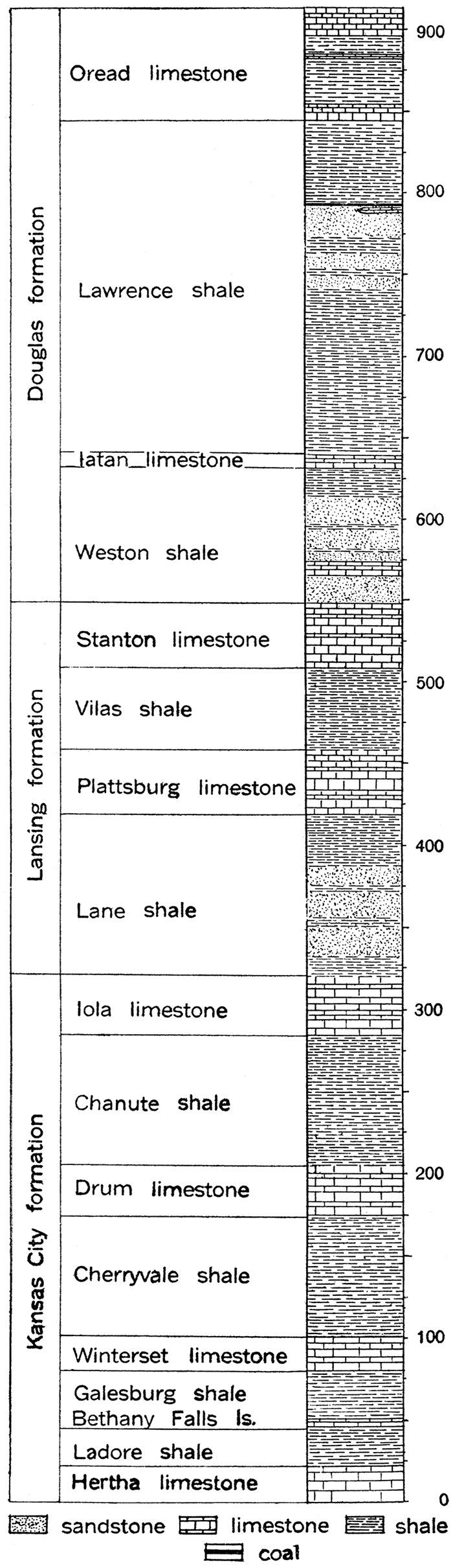
Figure 15—Generalized section of the Kansas City, Lansing and Douglas formations of the Missouri group of the Pennsylvanian in Kansas.
On the basis of lithologic character. and the contained fossils, the Missouri group has been divided into five formations. These, in their order from bottom to top, have been given the following names: Kansas City, Lansing, Douglas, Shawnee, Wabaunsee. Each of these formations will be described briefly.
Kansas City Formation
[Hinds and Greene, 1915, p. 23; named from Kansas City, Mo.]
At the base of the Missouri group is the Kansas City formation, which may be differentiated readily as a lithologic and faunal unit from other parts of the Pennsylvanian system in Kansas. Its outcrop forms a somewhat irregular but clearly defined belt trending slightly west of south from the vicinity of Kansas City to Montgomery county. It has been traced also a considerable distance beyond the borders of the state into Missouri and Oklahoma. The total thickness of the Kansas City formation varies from 200 to more than 300 feet, the thickness at Kansas City being about 225 feet (see Fig. 16). As observed at. its type locality, more than half of the formation consists of limestone, contrasting sharply with most of the associated formations. Shale members of the Kansas City are argillaceous or calcareous, but in some cases are black and slaty. There is very little sandstone in the formation, although thin beds occur locally. The Kansas City formation is one of the best-defined stratigraphic horizons in the eastern part of Kansas. As indicated in the table of formations, nine members of alternating limestone and shale are included in the Kansas City formation.
Hertha limestone member. (Adams and others, 1903, p. 35; named from Hertha, Neosho county, Kansas.) The Hertha limestone, erroneously called Bethany Falls limestone in earlier Kansas reports (Haworth, 1898a, p. 45-46, and 100-103; also, Haworth and Bennett, 1908, p. 89-91), is a resistant, heavy-bedded, gray, crystalline limestone, varying in thickness from a maximum of 22 feet, measured at Uniontown (Haworth and Bennett, 1908, p. 90), to nothing where it disappears to the south in the vicinity of Mound Valley. In Missouri the Hertha limestone has a thickness ranging from 4 to 18 feet (Hinds and Greene, 1915, p. 116). In some places the limestone is quite ferruginous, but elsewhere it bleaches to a nearly pure white. Because of its resistance to erosion it forms a well-marked escarpment above the soft Pleasanton shale of the Marmaton formation.
Ladore shale member. (Adams and Haworth, 1904, pl. 1; named from Ladore, Neosho county, Kansas.) The Ladore shale is a clayey or sandy shale which grades locally into shale, limestone or sandstone. It immediately overlies the Hertha limestone and appears at the surface to the west of the Hertha escarpment. The thickness of the Ladore ranges from less than three feet near Kansas City to a maximum of more than 40 feet near the southern border of the state. Towards the extreme south where the Hertha limestone is absent the Ladore shale rests directly upon the Pleasanton.
Bethany Falls limestone member. (Broadhead, 1868, p. 320; named from Bethany Falls, Harrison county, Missouri. This member has been called Mound Valley limestone in earlier Kansas reports.) Overlying the Ladore shale is the persistent Bethany Falls limestone, which has been traced from the southern part of Kansas across Missouri and into Iowa. As observed in the north part of its outcrop, this member consists of two main beds—the lower, a thick, massive, somewhat loosely cemented, unfossilferous limestone, which locally has a somewhat oolitic texture; and the upper, a rather thin-bedded, fossiliferous limestone. The formation is light or dark gray in color. Its thickness is about 22 or 23 feet at Kansas City, but farther south it is gradually smaller, until in the vicinity of Mound Valley it is less than 4 feet, and farther south it disappears.
Galesburg shale member. (Adams and others, 1903, p. 18; named from Galesburg, Neosho county, Kansas.) The Galesburg shale, overlying the Bethany Falls limestone, is a clay shale formation which changes locally to sandy or bituminous shale. The thickness of the member ranges from 5 or 6 feet, as observed in the vicinity of Kansas City, to 60 feet in northwestern Labette county.
Winterset limestone member. [Tilton and Bain, 1897, p. 517-519; named from Winterset, Madison county, Iowa. This member was called Dennis limestone in an earlier report (Haworth and Bennett, 1908, p. 93).] This member is a blue, thin-bedded limestone with buff shaly partings. Locally it is distinctly cross-bedded, and in its upper portion is characterized by an abundance of chert. The large amount of chert is perhaps the most prominent feature of the member, distinguishing it from other limestones of the formation. The main chert beds at Kansas City belong to the Winterset member. In the southern portion of the Winterset outcrop in Kansas the chert is so abundant that the cherty debris from the weathering of the member covers considerable areas. The chert is dark blue or nearly black and contains an abundant molluscan fauna. The thickness of the Winterset is nearly 30 feet at Kansas City and farther to the northwest in Missouri it reaches a maximum of 40 feet. Toward the southwest in Kansas, however, the formation becomes thinner, decreasing to less than 5 or 6 feet in the vicinity of Cherryvale. The member forms a prominent escarpment between Erie and Shaw.
Figure 16—Section of bluff at Kansas City, Mo., showing succession of limestones and shales. (U. S. Geol. Survey.)
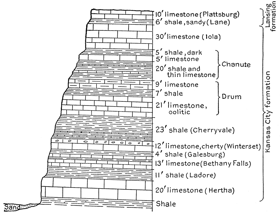
Cherryvale shale member. (Haworth, 1896, p. 483; named from Cherryvale, Montgomery county, Kansas.) Above the Winterset limestone is a rather thick argillaceous or calcareous shale, called the Cherryvale shale. Locally, as in the vicinity of Coffeyville, the Cherryvale shale is very sandy, but at Cherryvale it is a good clay shale and is extensively used in the manufacture of brick. Thin lenticular limestones occur in the shale toward the north. The maximum thickness of the Cherryvale, as recorded in the vicinity of its type locality, is about 125 feet, from which the thickness decreases northward to about 25 feet.
Drum limestone member. (Adams, 1903, p. 37; named from Drum Creek, Montgomery county, Kansas.) Succeeding the Cherryvale shale is the easily recognized Drum limestone, which is characterized by a rather persistent oolitic texture and by a distinctive fauna. Locally the Drum limestone is variable both in composition and texture. Notwithstanding its individual peculiarities which make it a desirable key horizon, the member does not have a great stratigraphic value on account of its extreme variability in thickness and its local discontinuity. The Drum limestone is recognized in the bluffs at Kansas City, where it is known familiarly as "the oolite," and is very prominent in southeastern Kansas in the vicinity of Coffeyville and Independence, but it has not been traced throughout its entire outcrop. The Drum ranges in thickness from a very few feet, or nothing at all, to as much as 80 feet, measured in Montgomery county.
Chanute shale member. (Haworth and Kirk, 1894, p. 109; named from Chanute, Neosho county, Kansas.) Overlying the Drum limestone is a rather variable composite member which has been given the name Chanute shale. In the vicinity of its type locality at Chanute it is a fine clay shale excellently adapted for brick manufacture, but at Independence and other points the shale is very sandy. East' of Neosho river the Chanute is represented by a sandstone which constitutes the main mass of the hills, and is exactly equivalent to the clay shales but a few miles distant. Locally the Chanute shale contains much bituminous matter and thin coal beds. In the vicinity of Thayer the coal is sufficiently important to be worked. The outcrop of the Chanute member is wide at the south and narrow at the north. Its thickness, as observed in Kansas, varies from 25 to 100 feet, the maximum occurring toward the south, where this member apparently coalesces with the shale member overlying the Iola. In the vicinity of Kansas City, Mo., the Chanute is represented by a succession of alternating shale and thin limestone beds which are rather persistent locally.
Iola limestone member. (Haworth and Kirk, 1894, p. 109; named from Chanute, Neosho county, Kansas.) The top member of the Kansas City formation is the Iola limestone, a light gray, somewhat crystalline, massive member which is very easily identified. It is, in general, rather free from joints, making it possible to obtain large blocks in quarrying. The Iola limestone is very resistant to weathering agencies and forms a well-defined escarpment along the line of its outcrop from Chanute and Iola northeastward to Kansas City. The escarpment crosses into Missouri at the southeast corner of Johnson county, but turns westward up Kansas river to De Soto, and toward Leavenworth on Missouri river as far as Walcott. Between Iola and Kansas City the member has a rather uniform thickness of 30 to 40 feet, but to the southwest and the northeast it becomes very much thinner or disappears. At Neodesha it is only one foot six inches thick (Haworth and Bennett, 1908, p. 99). The Iola limestone is one of the best-marked stratigraphic horizons in Kansas.
Lansing Formation
[Hinds Greene, 1915, p. 28; named from Lansing, Leavenworth county, Kansas.]
A very important faunal break, clearly defined by Beede and Rogers (1908, p. 318) and Girty (cited by Hinds and Greene, 1915, p. 155), occurs at the top of the Kansas City formation. Accordingly the beds above the Iola limestone which were formerly included in the Pottawatomie formation (Haworth, 1898a, p. 94; also Haworth and Bennett, 1908, p. 75.) have been separated from the underlying beds and named from typical outcrops in the vicinity of Lansing, near Leavenworth, the Lansing formation. Faunally, the Lansing fo-rmation appears to be continuous with the succeeding Douglas formation, but as the latter differs lithologically from the Lansing, and has been well defined in the literature for some time, it seems desirable to recognize both formations.
The Lansing formation has an approximate thickness of 140 feet in the north, but is somewhat less thick toward the south, where the shale is less important. The formation appears at the surface in a rather narrow band, which crosses the state in a direction slightly west of south from Leavenworth to the vicinity of Sedan, in Chautauqua county. Four subdivisions, two prominent limestone members and two shale members, are recognized.
Lane shale member. (Haworth and Kirk, 1895, p. 277; named from Lane, Franklin county, Kansas.) At the base of the Lansing formation is the Lane shale, having an average thickness of 50 to 60 feet, but reaching a maximum of about 150 feet towards the south. The lower part of the member is clayey and the upper part somewhat sandy, but there are local variations. As a whole the member is rather free from sand.
Plattsburg limestone member. [Broadhead, 1868, p. 317-327 (read May 5, 1862; first issued July 27, 1865.) Named from Plattsburg, Clinton county, Missouri. The name Allen limestone has been applied to this member in earlier Kansas reports.] This important limestone in the lower portion of the Lansing formation was defined by Broadhead as early as 1862 from exposures at Plattsburg, Mo., and although the name Allen limestone has been generally used by this Survey, it seems that there is no question of the priority of the term here employed. The Plattsburg is a fairly persistent horizon, but locally variable in its features. It is rather highly crystalline and massive and contains many fossils, the fauna being particularly interesting on account of its many fossil sponges. It differs from ordinary limestone in that it breaks very readily into small angular fragments. It is cherty in the upper part. The Plattsburg varies notably in thickness, ranging from 4 to 5 feet in some areas to 75 or 80 feet in others. To the northwest in Missouri and to the southwest in Oklahoma it gradually thins and disappears.
Vilas shale member. (Haworth and Adams, 1898, p. 51; named from Vilas, Wilson county, Kansas.) Separating the two limestone members of the Lansing is the lenticular Vilas shale, which ranges in thickness from 125 feet at a point south of Vilas to little more than 5 feet in the bluffs of Fall river at Neodesha, and to almost nothing farther south. It is notably thin also to the northeast, being only 5 feet at Kansas river and 3 or 4 feet in parts of northwestern Missouri. Where the Vilas shale is very thin, a single escarpment is made by the overlying Stanton limestone and the underlying Plattsburg, but where the shale is very thick the Stanton is weathered back four or five miles from the outcrop of the Plattsburg. The Vilas shale is both sandy and clayey, and in places includes black slaty shale, with thin coal seams.
Stanton limestone member. (Swallow, G. C., 1866, p. 75; named from Stanton, Miami county, Kansas.) The uppermost member of the Lansing formation is the Stanton limestone, composed of massive limestone beds separated by thin slaty beds. The limestone beds vary in thickness from 6 or 8 feet to 20 feet, and the persistent shale partings, which are rather rich in bituminous matter, from 4 to 8 feet. The total thickness of the Stanton varies from 20 to 40 feet, but it maintains a rather uniform development from point to point. With the underlying Allen member, the Stanton limestone forms one of the most prominent escarpments in eastern Kansas. It is traced with readiness from the southern border of the state, near Caney, to Neodesha, Altoona, and Benedict on Kansas river, and from Kansas City northeastward across Missouri. West of the escarpment there is an extensive dip slope, forming a zone from five to twenty miles in width. The dip slope of the Stanton west of Olathe, covered by a thin mantle of shale, extends all the way to Lawrence, a distance of nearly thirty miles.
Douglas Formation
[Haworth, 1898a, p. 93; named from Douglas county, Kansas.]
The Douglas formation is essentially a body of shale and sandstone with an important capping limestone member and a very thin, non-persistent limestone in its middle portion. The outcrop of the formation is a northeast, southwest zone from 5 to 30 miles in width, limited by the escarpments of the Stanton and Oread limestone members. The limestone at the top of the formation, though one of the thickest and most persistent limestones in the Kansas Pennsylvanian, comprises but a small portion of the entire formation. The shale members of the Douglas are variable in composition and texture, changing markedly from point to point. In the north there is a predominance of clay shale, which is sufficiently pure locally for use in brick manufacture, but toward the south the proportion of sand is notably increased. In places here the shale is replaced 'by thick, massive sandstone. Coal occurs at one or two horizons in the formation, but is not of great thickness and has been worked only locally.
The thickness of the Douglas formation ranges from about 350 feet to 550 feet, 425 feet being an average. Like the subjacent formation, the Douglas includes four members of alternating shale and limestone.
Weston shale member. (Keyes, 1899, p. 298-316; named from Weston, Platte county, Missouri. The name La Roy shale has been used by Haworth for this member.) The lowest member of the Douglas formation is the Weston shale, named from typical outcrops on Missouri river above Leavenworth. It consists of clayey and sandy shale and ranges in thickness from 60 to 100 feet. The shale is soft and weathers readily, a noticeable escarpment being formed where the overlying Iatan limestone member is well developed.
Iatan limestone member. (Keyes, 1899, p. 298-316; named from Iatan, Platte county, Missouri.) Overlying the Weston shale is the thin Iatan limestone, called by Haworth and Bennett (1908, p. 106) the Kickapoo limestone. In the north the Iatan is a dark to light gray limestone, thin and irregularly bedded or massive in character, weathering in large blocks. In Doniphan county, where it is persistent and well developed, it has a thickness of 15 feet. At Lawrence and Ottawa it is but 3 or 4 feet thick and at points to the south is scarcely recognizable. However, it has been identified in southern Kansas in the vicinity of Independence and elsewhere, where it forms a rather persistent horizon.
Lawrence shale member. (Haworth and Kirk, 1894, p. 110; named from Lawrence, Douglas county, Kansas.) The Lawrence shale consists of 150 to 300 feet of argillaceous shale and sandstone, containing in places coal seams and thin but rather persistent beds of limestone. The member is thinnest in the north and thickest in the south, where it is very sandy. The name "Chautauqua sandstone" has been suggested for the sandy phase of the Lawrence in Chautauqua county and the adjoining region (Adams, cited by Haworth, 1898a, p. 58-59). Coal in the Lawrence shale is of commercial importance in Franklin and Atchison counties. In Platte county, Missouri, there are interesting deposits of sandstone of Lawrence age (Hinds and Greene, 1915, p. 170.) which lie unconformably upon the lower members of the Douglas and the upper members of the Lansing formations. These sandstones with underlying basal conglomerates apparently represent deposits in ancient river channels, and indicate that the region in which they occur was lifted above sea level during Lawrence time. That emergence was local and temporary is shown by the limited distribution of the sandstones and by the presence of the Oread limestone above them.
Figure 17—Section of rocks exposed near Eudora and Lawrence, Kan. (U. S. Geol. Survey.)
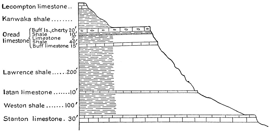
Oread limestone member. (Haworth, 1894, p. 123-124; named from Mt, Oread, Lawrence, Kan. The State University is located on Mt. Oread.) The Oread limestone, consisting of three distinct limestone beds separated by shale beds, is one of the most important divisions of the Upper Pennsylvanian in Kansas. The lower limestone bed is buff brown or gray in color, massively bedded, and 8 to 12 feet in thickness. Upon it rests 20 to 60 feet of blue or drab shale. The middle limestone of the Oread, which succeeds, has a uniform thickness of less than 3 feet, but is traced from the north to the south limit of the state. The overlying shale is in .part blue-gray and in part black, bituminous, and thinly bedded. It has a total thickness of 6 to 15 feet. The upper division of the Oread is a thin-bedded, cherty, buff limestone, 10 to 25 feet thick. It has uneven, wavy shale partings and is readily distinguished from the thick-bedded, essentially non-cherty lower Oread limestone. The average thickness of the entire member is 50 to 70 feet. It is resistant to erosion and forms a prominent escarpment extending entirely across Kansas.
Shawnee Formation
[Haworth, 1898a, p. 93-94; named from Shawnee county, Kansas.]
Immediately overlying the Douglas division is the Shawnee formation, consisting of alternating limestone and shale members, most of which are traceable entirely across the state. Quantitatively the shales are much the most important, constituting more than three-fourths of the entire formation. The thin shale members are predominantly argillaceous or calcareous, the thick members arenaceous and micaceous. Black slaty shale and thin coal seams are found at a number of horizons in the formation. The Shawnee formation crops out in a broad belt extending from Doniphan and Atchison counties on the northeast to central Chautauqua county on the southwest. Subdivisions of the formation are well developed and persistent throughout the area of the Shawnee outcrop, but may be studied to best advantage where exposed in their type localities along Kansas river. The maximum thickness of the Shawnee is slightly more than 500 feet, but at certain localities it is possibly not more than 375 or 400 feet. It has been suggested by the paleontologic study of Beede and Rogers (1908, p. 345-346) that the upper boundary of the Shawnee. formations should be drawn at the base of the Scranton shale instead of at the base of the succeeding Burlingame limestone; but such a change in classification has not been adopted formally. Nine subdivisions of alternating shale and limestone are recognized in. the Shawnee formation.
Kanwaka shale member. (Adams, 1903, p. 45; named from Kanwaka township, Douglas county, Kansas.) The basal member of the Shawnee formation is the Kanwaka shale; which consists of 50 to 100 feet of clayey shale and sandstone. Thin seams of coal have been observed, but they have no commercial value. In northern Kansas the shale is calcareous and locally includes thin beds of impure limestone, but toward the south it is very sandy and may well be termed sandstone. The name Elgin sandstone has been suggested (Haworth, 1898a, p. 64) for this phase of the member on account of exposures near Elgin in southern Chautauqua county. Here the sandstone is nearly 140 feet thick, but toward the south in Oklahoma it becomes thinner. The Elgin sandstone is probably the "1,000-foot" sand of the Ponca City field and the "970-foot" sand of the Newkirk pool, in both of which areas it contains oil (Shannon and Trout, 1911, p. 90).
Figure 18—Generalized section of the Shawnee and Wabaunsee formations of the Missouri group of the Pennsylvanian in Kansas.
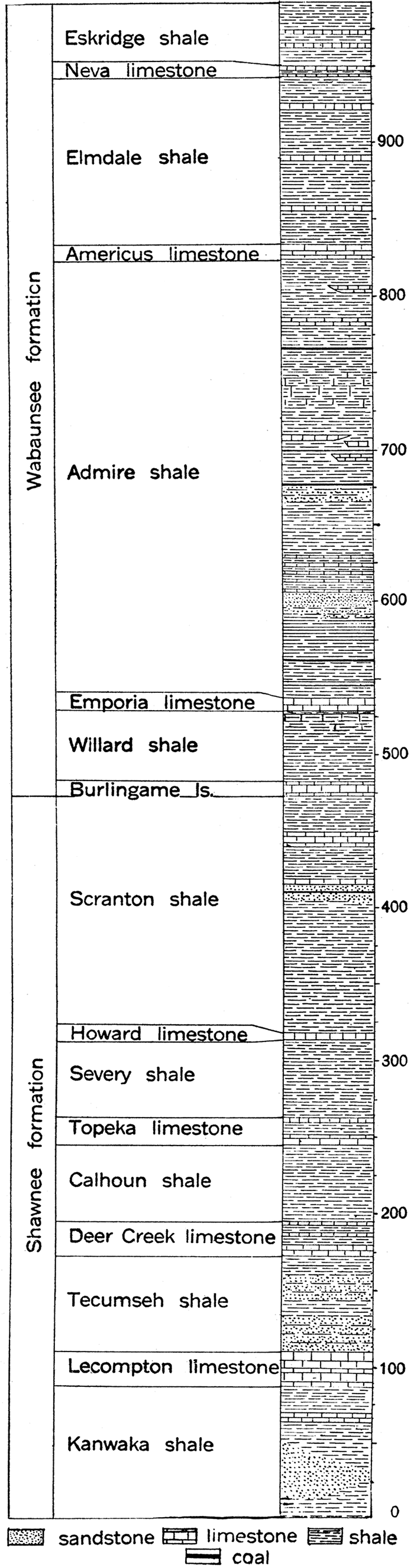
Lecompton limestone member. (Bennett, 1896, p. 116; named from Lecompton, Douglas county, Kansas.) The Lecompton member consists of limestone and thin shale beds having a total thickness of 15 to 30 feet. The interbedded shales of the Lecompton increase in thickness toward the south. The limestone is yellowish gray in color and weathers to yellowish brown. It is fossiliferous, containing especially large numbers of Fusulina and sea-urchin spines. The beds are somewhat soft, and are sometimes reported by drillers as chalk rock.
Tecumseh shale member. (Beede, 1898a, p. 27-34; named from Tecumseh, Shawnee county, Kansas.) Arenaceous shales, or shaly sandstone ranging in thickness from 40 to 70 feet, overlie the Lecompton and are traced from Kansas river to the southern border of the state. This member, called the Tecumseh shale, weathers readily and a prominent escarpment is produced by the succeeding limestone.
Deer Creek limestone member. (Bennett, 1896, p. 117; named from Deer creek, Shawnee county, Kansas.) Succeeding the Tecumseh shale are three limestone beds with thin intervening shale beds, which are grouped to form the Deer Creek limestone. The average thickness of the limestones from bottom to top, as measured along Kansas river, are, respectively, 6, 2 and 5 feet, while that of the shales is 10 and 4 feet, making a total thickness of 20 to 30 feet for the member. The limestones of the Deer Creek are buff or gray in color and rather thin-bedded. The upper bed is cherty and locally has an oolitic texture. In southern Kansas the Deer Creek limestone has a bluish color and is much jointed and broken.
Calhoun shale member. (Beede, 1898a, p. 29; named from Calhoun, Shawnee county, Kansas.) The Calhoun shale overlying the Deer Creek limestone is a rather argillaceous shale, 50 feet thick near its type locality on Kansas river, but thinner both to the north and south. It contains thin beds of bluish limestone in some localities.
Topeka limestone member. (Bennett, 1896, p. 116-117; named from Topeka, Shawnee county, Kansas.) The Topeka limestone comprises 20 to 25 feet of blue and buff limestone with interbedded shales, all of which, with the exception of a rather persistent layer of black slaty shale, weathers to a deep buff color. The Topeka limestone does not form a prominent escarpment, but takes part in the dip slope of the Deer Creek limestone.
Severy shale member. (Haworth, 1898a, p. 67; (G. I. Adams' field work) named from Severy, Greenwood county, Kansas.) The Severy shale, overlying the Topeka limestone, varies in thickness from 40 to 60 feet. It is mainly an argillaceous shale, but is locally quite sandy and the upper part is in places very rich in bituminous matter. The Severy shale member contains coal beds of good grade from 8 to 20 inches in thickness in the vicinity of Osage county, Kansas, and in parts of northwestern Missouri.
Figure 19—Section showing succession of rocks in plateau south of Topeka, Kan. (U. S. Geol. Survey).
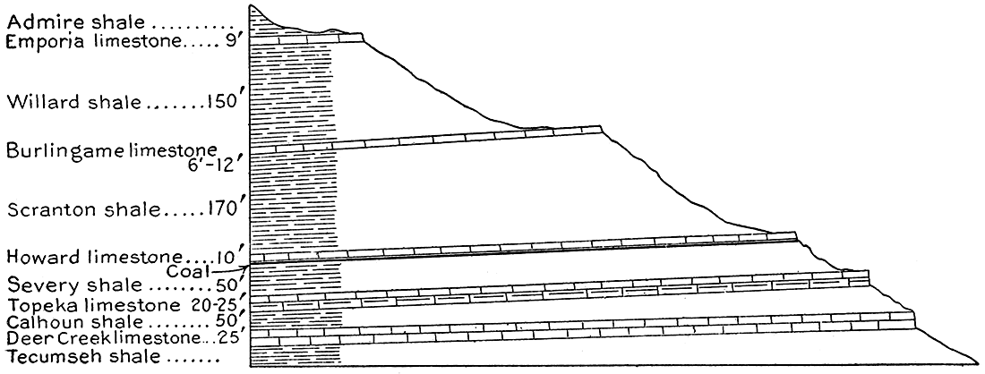
Howard limestone member. (Adams, quoted by Haworth, 1898a, p. 67; named from Howard, Elk county, Kansas.) Lying a few feet above the top coal of the Severy shale at Scranton, Carbondale, Osage City and Topeka is the Howard limestone member, consisting of two main limestone beds separated by 1 or 2. feet of shale. The thickness of the whole member is but 3 to 7 feet, and its persistency is remarkable. The Howard is often reported in drilling as solid limestone.
Scranton shale member. (Haworth and Bennett, 1908, p. 112; named from Scranton, Osage county, Kansas.) At the top of the Shawnee formation is the Scranton shale member, 160 to 200 feet in thickness. The lower part of the Scranton is prevailingly clay and sandy shale or sandstone; the upper part contains a number of shales. The Scranton shale is easily eroded, making prominent the succeeding escarpment of the Burlingame limestone.
Wabaunsee Formation
[Prosser, 1895a, p. 682-705 and 764-800; named from Wabaunsee county, Kansas.]
The Wabaunsee formation, comprising the upper portion of the Pennsylvanian system in Kansas, has been defined to include the limestones and shales above the Howard limestone and underlying the well-defined horizon of the Cottonwood limestone. It is recognized that this grouping traverses a marked faunal change at the base of the Elmdale member (Beede and Rogers, 1908, p. 349, 432), and that the lower limit of the formation does not coincide with the faunal transition indicated by Beede and Rogers at the base of the Scranton shale. It will doubtless be necessary to reclassify the stratigraphic divisions near the top of the Pennsylvanian and the base of the Permian. However, in this report, which is not primarily concerned with problems of stratigraphy, it does not seem wise to depart from the grouping previously employed by this Survey and the United States Geological Survey.
The outcrop of the Wabaunsee, limited on the west by the prominent "Flint Hills" escarpment of the Cottonwood and Wreford limestones, appears as a north-south band across the state, wide at the north but narrowing markedly toward the south. Important westward extensions occur up the valleys of Kansas and Cottonwood rivers. The thickness of the Wabaunsee is about 500 feet. Eight members consisting of rather thin limestones and thick shales are recognized as distinct stratigraphic units in Kansas.
Burlingame limestone member. [Haworth, 1898a, p. 72; (Extract from Hall's Osage River Section, vol. 1.) Named from Burlingame, Osage county, Kansas.] At the base of the Wabaunsee is the persistent Burlingame limestone, 7 to 12 feet in thickness, composed of two main limestone layers, yellow or brown in color, separated by shale. It is a massive ledge which forms a prominent escarpment readily traced across the state.
Willard shale member. (Beede, 1898, p. 31; named from Willard. Shawnee county, Kansas.) The Willard shale is a rather thin member immediately above the Burlingame limestone, composed of blue and yellow shale, with a small amount of friable limestone. Its thickness in Lyon county, where it is typically developed, is about 45 or 55 feet.
Emporia limestone member. (Kirk, M. Z., 1896, p. 80; named from Emporia, Lyon county, Kansas.) Above the shale thus defined is about 9 feet of hard blue limestone of sufficient stratigraphic importance to receive recognition as a distinct member under the name Emporia limestone. The Emporia consists of two limestone beds, the lower 3 feet in thickness and the upper 2 feet, separated by about 4 feet of shale. It has been traced from Greenwood county across Lyon and Wabaunsee counties into Shawnee county. On account of its characteristic blue color it was called the "Emporia blue limestone" by Smith in his account of the geology of Lyon county (Smith, 1902, p. 2-10; also Smith, 1901, p. 193).
Admire shale member. (Adams, 1903, p. 53; named from Admire, Lyon county, Kansas.) A thick succession of shale and sandstone with thin beds of limestone and coal is included in the Admire shale member. The total thickness of the member in Lyon county is approximately 300 feet. About 70 feet above the base of the Admire are five thin limestone beds called by Smith (Smith, 1902, p. 2-10) "the Emporia system," and mapped by Adams (Adams, 1903, p. 53) as the Emporia limestone. Some confusion has therefore arisen with regard to the true character of the Emporia member. It appears that the higher limestones are non-persistent, not even extending across Lyon county, and are hardly entitled to rank as a distinct subdivision. The upper portion of the Admire consists of sandy shale and soft, massive sandstone.
Americus limestone member. (Kirk, 1896, p. 80; named from Americus, Lyon county, Kansas.) Overlying the Admire shale is a thin, rather persistent limestone 8 feet in thickness. Along its outcrop, at the edge of the escarpment which it forms over the Admire, it is characteristically broken into large blocks which are strewn down the slope beneath.
Elmdale shale member. (Prosser, 1902, p. 718, diagram; named from Elmdale, Chase county, Kansas.) The Elmdale shale consists of approximately 130 feet of variegated. shale and thin interbedded limestone, the shale predominantly yellow to bluish in color, the limestone gray. About 30 feet above the base of the member is a very friable limestone bed composed almost entirely of the wheat-grain-like shells of the minute protozoan Fusulina, and about 30 feet higher there is a conspicuous yellow limestone. The Elmdale shale has been studied especially in the region west of Cottonwood Falls, but has been recognized to a considerable distance north and south.
Neva limestone member. (Prosser, 1902, p. 718, diagram; named from Neva, Chase county, Kansas.) Succeeding the Elmdale shale are two beds of massive bluish-gray limestone, each a little more than 4 feet in thickness, separated by about 2 feet of shale, which form together the Neva limestone member. The limestone makes a prominent bench and breaks off at the outcrop in large rectangular blocks with rough, jagged surfaces. They weather to a very light color, which has been well likened to the color of bleached bones. The Neva limestone becomes thinner to the north, but has been traced into Oklahoma far south of the Kansas line. The southern portion of the Neva member in Oklahoma is, however, represented by sandstone (Beede, 1914, p. 7-21). The Neva limestone, or perhaps the Elmdale shale, should be regarded as the base of the Permian, according to Beede (Beede, 1914, p. 21).
Eskridge shale member. (Prosser, 1902, p. 718; named from Eskridge, Wabaunsee county, Kansas.) Between the Neva and the succeeding prominent limestone at the base of the Permian is the Eskridge shale member, 30 to 40 feet in thickness. The shale is green, brown or yellow in color, and being easily weathered like other shale members is represented at its outcrop by a gentle, grass-covered slope. (Fig. 21).
Permian System
General Description
Distribution. Adjacent to the Pennsylvanian outcrops on the west, and occupying an important zone in a north- south direction across central Kansas, is a group of rocks which are referred to the highest division of the Paleozoic era, the Permian period. This zone, narrow at the north where it is encroached from the west by the much younger beds of the Cretaceous, reaches its maximum width near the south border of the state, the Permian outcrop here extending from central Cowley county on the east to the west line of Clark county on the west. Thus the Permian of Kansas comprises a roughly triangular area with its apex at the north and its base on the south state line (see geologic maps Plates I and XI). In Oklahoma the Permian covers most of the western part of the state.
A knowledge of the Permian rocks is of vital importance to the oil producer because of their relation to the very valuable, recently discovered pools in Butler and Cowley counties, and other districts within the area of the Permian outcrop. While large quantities of oil and gas have not thus far been discovered in the Permian itself—although there is no inherent reason which precludes such discovery—rocks of the Permian must be drilled in any search for these fuels in central Kansas and Permian rocks will probably be encountered in most tests of sufficient depth throughout the western part of the state.
Thickness. It is difficult to make any definite or general statement with regard to the thickness of the Permian in Kansas. Of course, the coyer of Permian rocks is thinnest near the eastern border of the Permian outcrop, where only the lowest divisions are present, and thickest near the Cretaceous boundary. It appears also that the Permian is very thin in the north and reaches a maximum thickness in Kansas toward the south, in Sumner and Harper counties. A well drilled at Anthony, in Harper county, encountered 1,100 (?) feet of red beds, salt and gypsum, and is the greatest single measurement of these rocks. Observation of surface outcrops indicate an average total thickness of 1,100 feet for the lower non-red Permian and about 1,200 feet for the upper red-beds Permian.
Lithologic Character. The Permian of Kansas includes two very distinct lithologic and stratigraphic divisions, a lower portion consisting of marine shales, limestones and sandstones, lithologically almost exactly like the underlying Pennsylvanian, and an upper portion essentially composed of non-marine red shales and sandstone. There are thick salt beds and some gypsum deposits in the upper part of the lower division (Fig. 20), and extensive gypsum beds in the upper division. The marine limestones and shales are chiefly developed in the northern and eastern part of the Permian outcrop, while the "red beds" are restricted to the southwestern part of the Permian area in the state. A short distance south of Kansas the non-red Permian limestones and shales disappear, being replaced by beds of red shale and sandstone. It appears that the red Permian rocks are not entirely different in age from the non-red beds, though for the most part they are distinctly younger. In deed, there are red beds of Pennsylvanian age in central Oklahoma which show the coming of the conditions of red-bed sedimentation in this region even before Permian time (Snider, 1913, p. 113).
The Permian limestones are essentially like those of the Pennsylvanian, with the exception that they are in general much more filled with chert. The chert is so abundant in some divisions that they might well be called chert members rather than limestone members. The limestones are in most cases fine grained and noncrystalline. They are, like the limestone members of the Pennsylvanian, rather thin but strikingly persistent. In color they range from light gray or yellow to deep brown, and some of them are remarkably fossiliferous. The shale beds are quantitatively much the most important part of the lower Permian, comprising practically the whole of the formations where the limestones thin out. They are argillaceous rather than sandy, but grade locally into soft shaly sandstones. They vary in color from light gray, green or yellow to brown, and in a few cases reddish purple. The shales are not very fossiliferous, as a rule, but some of the shale members are literally crowded with excellently preserved fossil shells. Sandstones are relatively unimportant and non-persistent. The salt beds are remarkably thick and pure in the upper part of the lower Permian, measuring about 400 feet in total thickness between Hutchinson and Kingman. The salt is in part interbedded with shale, but with little associated gypsum or limestone. The salt beds do not outcrop in any part of the state, but have been recognized throughout a considerable area in deep drilling. Gypsum beds are of local occurrence and relatively slight thickness in the lower Permian. They are reported from horizons underlying the salt beds in north central Kansas.
The "red beds" division of the Permian, as indicated by the name generally applied, is chiefly characterized by the red color of the formations, both shale and sandstone. Limestone is conspicuously lacking. The shales are clayey or sandy and grade laterally in many places into sandstone. The sandstones, which are most commonly cross-bedded, are irregular in thickness and non-persistent. Gypsum beds appear to be the only fairly reliable stratigraphic markers, and where chiefly developed&nmdash;in southern Kansas and Oklahoma—they have been used in the subdivision and mapping of the group. The red-beds gypsum of Kansas is best exposed in Clark, Comanche and Barber counties. A thin member of dolomite is reported in the southwest part of the Permian outcrop in Kansas.
Faunal Character. The fauna of the lower Permian is a derivative of that of the uppermost Pennsylvanian of the region, and is only distinguished from it by the presence of certain younger types which belong to the new period. So gradual is the faunal transition from one system to the other in Kansas, and so unmarked by evidence of physical change, that the line of division has long been unsettled. Final classification must rest on extensive, careful and detailed paleontologic studies. No fossils have been found in the red beds of Kansas, but numerous discoveries in the similar beds of Oklahoma and Texas indicate without question the Permian age of this division. The fauna consists chiefly of vertebrates.
Subdivisions. The lower non-red division of the Permian is called the Big Blue group (Cragin, 1896a, p. 3, 5) from typical development along the river of that name between Pottawatomie and Riley counties, Kansas. The red beds division is included in the Cimarron group (Cragin, 1896a, p. 18-48). the name being taken from Cimarron river, which crosses the outcrop of the beds in southwestern Kansas and northwestern Oklahoma. The following table indicates the subdivisions of the Permian in Kansas as now defined,
| Subdivisions of the Permian system in Kansas | ||
|---|---|---|
| Group | Formation | Member |
| Cimarron | Greer | Big Basin sandstone |
| Hackberry shale | ||
| Woodward | Day Creek dolomite | |
| Whitehorse sandstone | ||
| Dog Creek shale | ||
| Cave Creek | Shimer gypsum | |
| Jenkins shale | ||
| Medicine Lodge gypsum | ||
| Enid | Flowerpot shale | |
| Cedar Hills sandstone | ||
| Salt Plain shale | ||
| Harper sandstone | ||
| Big Blue | Wellington | Undifferentiated |
| Marion | Abilene conglomerate | |
| Pearl shale | ||
| Herington limestone | ||
| Enterprise shale | ||
| Luta limestone | ||
| Chase | Winfield limestone | |
| Doyle shale | ||
| Fort Riley limestone | ||
| Florence flint | ||
| Matfield shale | ||
| Wreford limestone | ||
| Council Grove | Garrison shale and limestone | |
| Cottonwood limestone | ||
Big Blue Group
The general stratigraphic relations and lithologic character of the Big Blue group of the Permian has been sufficiently given in the foregoing general description. A more detailed account of the subdivisions of the group, under appropriate headings, follows. The formations recognized in Kansas are four in number, named in order from below: Council Grove, Chase, Marion, and Wellington.
Figure 20—Generalized section of the Big Blue group of the Permian in Kansas.
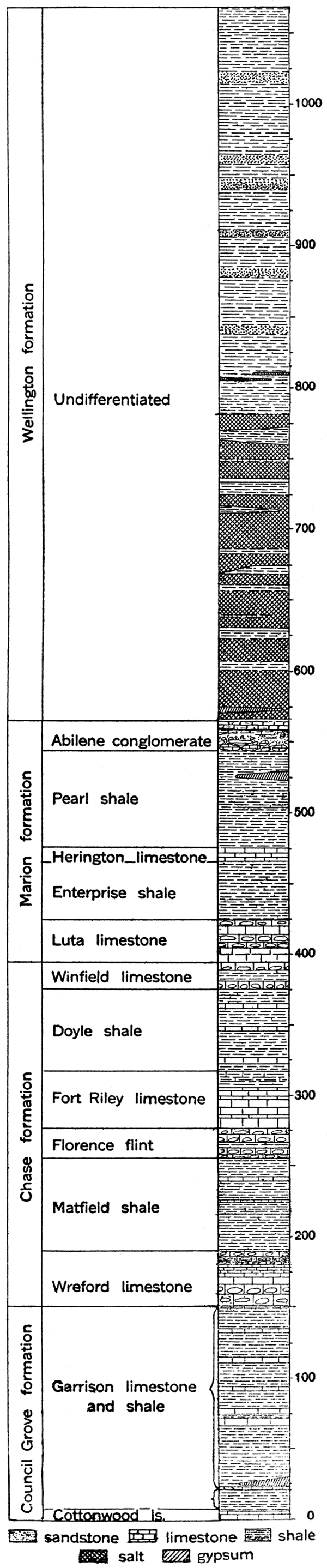
Council Grove Formation
[Prosser, 1902, p. 718; named from Council Grove, Morris county, Kansas.]
At the base of the Permian, as here defined, and resting conformably on the subjacent Pennsylvanian, is the Council Grove formation, consisting of a very prominent, resistant and easily recognized limestone member and a succeeding member of interbedded shale and limestone. The lower is termed the Cottonwood limestone member and the upper the Garrison shale and limestone member. The formation is most typically developed in the central portion of the state, but has been traced without change a considerable distance to the north and south. Its thickness is about 150 feet. Its outcrop, which is very narrow on account of the very resistant character of the succeeding Wreford cherty limestone, forms a band bordering the east line of the Permian, and coincides approximately with the east face of the so-called Flint Hills. The Council Grove formation marks the transition in lithologic and faunal characters from the Pennsylvanian to the Permian.
Cottonwood limestone member. (Prosser, 1902, p. 711, 712; named from Cottonwood river, Chase county, Kansas.) The Cottonwood limestone is one of the most persistent and easily recognized horizons in Kansas, its outcrop extending without break from Nebraska into Oklahoma. The limestone is light gray or buff in color; massively bedded, and has an average thickness of about six feet. The upper part of the member is almost entirely made up of the small wheat- or rice-shaped protozoans, Fusulina secalica, but there are few other animal remains. The line of outcrop of the Cottonwood is generally marked by a row of massive rectangular blocks of light gray or bleached, bone-colored limestone. Because of its resistance to weathering it forms a prominent escarpment. The persistence of the lithologic character of the Cottonwood limestone is noteworthy.
Garrison limestone and shale member. (Prosser, 1902, p. 711, 712; named from Garrison, Pottawatomie county, Kansas.) Overlying the Cottonwood are yellowish shales with thin intercalated limestone beds, which are included in the Garrison shale and limestone member. This division constitutes by far the greatest portion of the Council Grove formation, having a thickness of 135 to 150 feet. As recognized in the type area of the member, there are two main divisions in the Garrison—a lower shale, called the Florena shale bed, which is characterized by the abundance and fine preservation of its fossils, mostly belonging to a single brachiopod species, Chonetes granulifer; and an upper division, called the Neosho bed, consisting of green, chocolate or yellow shales alternating with thin beds of grayish limestone. Near the base of the Neosho bed in the Big Blue valley a bed of gypsum is found. The shales of the Garrison member weather readily and form the slope of the escarpment made by the overlying Wreford limestone.
Chase Formation
[Prosser, 1902, p. 713-714; named from Chase county, Kansas.]
The Chase formation constitutes a well-defined lithologic and faunal division of the Permian in Kansas. Lithologically, the abundance of limestone and hard, resistant chert is most noteworthy, the outcrop of this formation forming the most prominent topographic feature of central Kansas, the Flint Hills, which extend northward from Oklahoma almost to Nebraska. The eastern boundary of the formation approaches closely that of the Cottonwood limestone at the base of the Permian, and the outcrop as a whole is rather narrow on account of the resistant character of the upper members. In the north where covered by glacial drift the outcrop is somewhat obscured, but to the south the various members are clearly defined. The Chase formation has a thickness of about 230 to 270 feet.
Figure 21—Section across Cottonwood valley southwest of Elmdale, Kan., showing rock terraces or steps formed by resistant limestone beds and gentle slopes composed of shales. Cm, Matfield shale; Cwf, Wreford limestone; Cg, Garrison formation; Cc, Cottonwood limestone; Ce, Eskridge shale; Cn, Neva limestone; Ced, Elmdale formation. (U. S. Geol. Survey.)
Wreford limestone member. (Hay, 1893; named from Wreford, Geary county, Kansas.) The lowest subdivision of the Chase formation is the Wreford limestone consisting of 35 to 50 feet of massive limestone and chert, or flint. As observed in most places it is composed of three main beds, a cherty limestone below and above separated by a heavy limestone nearly free from chert. Locally the middle non-cherty bed is replaced by a layer of shale. The rock is gray to buff in color, massive and very resistant to weathering agencies. It forms the first prominent escarpment above the Cottonwood limestone. Towards the south the Wreford is imperfectly solidified and weathers to a reddish brown, very porous rock.
Matfield shale member. (Prosser, 1902, p. 718, diagram; named from Matfield, Chase county, Kansas.) Overlying the Wreford limestone is the Matfield shale member, which includes 60 to 70 feet of variously colored shale and thin interbedded shaly and occasionally cherty limestones. This shale member forms the slope between the Wreford and the succeeding Florence flint, and does not have a wide outcrop at the surface.
Plate XIII—Northern end of Gypsum Hills, near Medicine Lodge, Barber county, showing typical bad lands of the red beds.
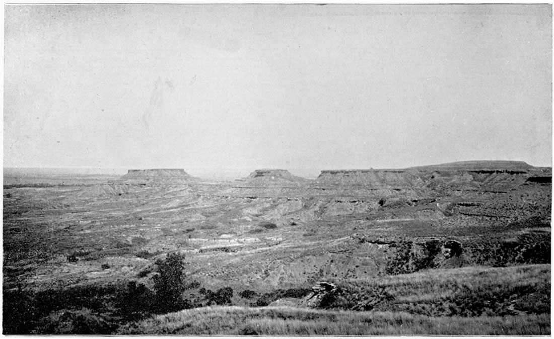
Florence flint member. (Prosser, 1895a, p. 773; named from Florence, Marion county, Kansas.) This subdivision of the Chase formation consists of about 20 feet of very flinty limestone, a number of layers being composed wholly of flint. Near the center of the member is a band of shaly, white, cellular limestone. Good exposures of the Florence flint occur at Oketo, Grant, Valencia and at Florence. The member is very resistant to erosion and forms a distinct escarpment with a well-defined dip slope, which extends for some distance to the west. Its outcrop closely parallels that of the Wreford limestone.
Fort Riley limestone member. (Swallow, 1866, p. 14; named from Fort Riley, Geary county, Kansas.) Massive buff limestone with thin interbedded shaly strata in the upper part is included in the Fort Riley limestone, measuring 40 to 45 feet in thickness. Near the center of the member are one or two very massive layers, which form a conspicuous bench at the outcrop, which is thus readily traceable for miles. The basal portion of the Fort Riley is either shaly or marly and is represented at Oketo, Marysville and Junction City by 6 to 9 feet of fossiliferous, calcareous shale.
Doyle shale member. (Prosser, 1902, p. 718, diagram; named from Doyle creek, Marion county, Kansas.) Overlying the Florence and the Fort Riley members is about 60 feet of variously colored shale, called the Doyle shale member. Grayish limestone beds appear in the shale, but the member weathers readily and the outcrop appears as a gently undulating prairie, in sharp contrast to the rough topography produced by the massive limestone and flint beds below. The outcrop of the Doyle shale is also distinctly wider than those of the immediately subjacent divisions.
Winfield limestone member. (Prosser, 1897c, p. 64; named from Winfield, Cowley county, Kansas.) At the top of the Chase formation is the highest chert horizon in the Kansas Permian, the Winfield limestone, which consists of two main cherty limestones separated by thin yellowish shale, North of Kansas river the Winfield limestone is not conspicuous and is apparently much thinner than in the southern portion of the state, where it forms a very conspicuous escarpment, well shown in the vicinity of its type locality at Winfield in Cowley county. The outcrop of the Winfield covers a much wider zone to the south, also, than to the north. The chert of the Winfield is not so uniform in character or so widely distributed as that of the Wreford or Florence members, and in some localities the horizon is represented simply by a prominent gray limestone. It may be traced across country either by the escarpment which it forms or from the zone of loose reddish-brown concretions which in places stretch across the prairie. The thickness of the Winfield limestone is about 20 to 25 feet.
Marion Formation
[Prosser, 1895a, p. 786; named from Marion county, Kansas.]
The Marion formation comprises the uppermost fossiliferous portion of the marine Permian of Kansas. It is a well-marked stratigraphic unit, clearly defined from the beds above and below it. It lacks the very cherty character of the Chase formation, from which it is also clearly distinguished by its fauna, and is separated from the overlying Wellington formation by its lack of salt beds, its light color and its content of limestone, which is practically absent in the Wellington. Marine invertebrate fossils are common in the Marion formation, but are very rare or lacking altogether in the Wellington. Buff, thin-bedded limestone and thick shale beds compose the Marion formation, well-developed beds of gypsum being present also at certain localities. A peculiar, somewhat variable conglomeratic limestone occurs at its top. The outcrop of the Marion is characterized by broad, rather gentle slopes, in decided contrast to that of the Chase formation in the Flint Hills farther east. The formation has a total thickness of about 150 feet. The Marion has been divided into five stratigraphic subdivisions, a portion of which have been mapped (Beede, 1908, p. 248-256).
Luta limestone member. (Beede, 1908, p. 251; named from Luta brook, which enters Antelope creek just north of Marion, Marion county, Kansas.) Over a very considerable portion of central Kansas the Luta limestone forms the basal member of the Marion formation. It is a more or less cellular, soft, gray limestone, 30 feet in thickness and contains siliceous geodes and layers of more or less abundant chert. The Luta limestone is well exposed in and about the town of Marion and is seen at Herington, from which point it may be traced north to Smoky Hill river. Southward it appears to become much thinner, being barely recognizable at Arkansas City and apparently disappearing in the section east of Newkirk, Okla. (Beede, 1908), The member is thickest at Marion.
Enterprise shale member. (Beede, 1908, p. 253; named from Enterprise, Dickinson county, Kansas.) Overlying the Luta limestone is the Enterprise shale, typically exposed in the vicinity of the town of Enterprise, Dickinson county, on Smoky Hill river. The member consists of variegated shale, green, yellow and maroon in color, and has an average thickness in the central portion of the state of 35 feet. It has been recognized as far south as Kay county, Oklahoma (Beede, 1908). At Arkansas City the Enterprise shale is 44 feet thick (Beede, 1905, p. 108).
Herington limestone member. (Beede, 1908, p. 253; named from Herington, Dickinson county, Kansas.) Succeeding the Enterprise shale is a buff, massive, very fossiliferous limestone, which from typical outcrops in the vicinity of Herington, north of Marion, has been called the Herington limestone. The member is quite persistent and has been mapped from Smoky Hill river to a point south of Marion. It outcrops in the vicinity of Arkansas City, where it is about 15 feet thick. The average thickness of the formation is 12 to 15 feet.
Pearl shale member. (Beede, 1908, p. 255; named from Pearl, Dickinson county, Kansas.) A succession of green, blue and reddish shale, termed the Pearl shale member, overlies the Herington limestone. On account of lack of resistance of the overlying beds, outcrops of the Pearl shale are very uncommon. The thickness of the member is estimated to be 70 feet.
Abilene conglomerate member. (Prosser, 1895a, p. 682-705, 764-800; named from Abilene, Dickinson county, Kansas.) At the top of the Marion formation is an irregular, somewhat conglomeratic limestone division defined by Prosser from typical exposures, first described by Meek and Hayden (1860, p. 16-17), in the vicinity of the town of Abilene. At the type locality the member is a calcareous conglomerate containing some sand and sandstone pebbles. In the vicinity of Herington and Marion it is represented, according to Beede (1908, p. 256), by "heavy, hard, perhaps dolomitic stone, composed of fragments of yellow, orange and gray masses firmly united in a light gray cementing material." It forms a weak escarpment, which has been followed by Beede to a point south of Marion. It appears to have sufficient continuity to be mapped over a larger area.
Wellington Formation
[Cragin, 1896a, p. 17; named from Wellington, Sumner county, Kansas.]
The upper division of the Big Blue group is "a thick body of blue-gray and slate-colored shales" and important salt beds, to which the name Wellington formation is given on account of its typical development in the vicinity of the county seat of Sumner county. (Fig. 20.) By Haworth (1899, p. 89: Geology of Kansas salts) and Kirk (1899, pls. 5 and 6: Kansas salt) the name Wellington shale was restricted to the upper part of the formations as here defined, and the lower strata were designated "salt beds." Inasmuch as the salt deposits are very closely associated with the shales, it is regarded most desirable to group all the beds above the Marion and beneath the "red beds" as a unit which may be called the Wellington formation. The salt strata do not appear at the surface, and therefore can not be mapped, but may be considered as a subdivision of ths Wellington.
The outcrop of the Wellington formation occupies almost the whole western half of the Permian area in central Kansas where the "red beds" Permian does not appear; but in the southwest the Wellington is overlain by the Cimarron group, west of Kingman and Harper counties. The formation has not been mapped in the field and the precise limits of its outcrops can not be given, but it is known to be restricted essentiallv to the country south of Abilene-the outcrop extending only a short distance north of Smoky Hill river-and west of a line passing between Marion and Newton and east of Wichita and Wellington. It is relatively a thick formation, amounting in most places to more than 500 feet. The thickness of the Wellington, as it appears, is much less in the north than in the south, a condition which is probably due both to an original difference in thickness and to the covering of the uppermost beds of the formation in the north by the eastward overlap of the Cretaceous strata. As indcated by well records (Kirk, 1899), the thickness of the Wellington at Anthony is 799 feet, at Kingman 630 feet, at Hutchinson 578 feet, and at Kanopolis 485 feet. Prosser (1897, p. 67) estimates the thickness of the part of the Wellington shale overlying the salt member in Saline county at about 200 feet. As already indicated, the Wellington is chiefly a shale formation with thick salt beds in its lower portion. Limestone, though found in occasional thin layers, is not persistent or abundant and in general is conspicuously lacking. The shale is prevailingly blue, gray and yellow in color, with greenish and reddish bands of various thicknesses. The gray or blue tone of the Wellington is in strong contrast to the prevailing red color of the succeeding Cimarron beds. The shales are as a whole decidedly argillaceous in character.
Cimarron Group
[Cragin, 1896a, p. 3]
The upper or "red-beds" division of the Permian in Kansas, termed the Cimarron group, includes the surface rocks of a considerable area in southwestern Kansas. However, the outcrop of the group in Kansas represents only the northern end of a wide belt of red beds, which covers almost the entire western half of Oklahoma and reaches nearly to Pecos river in southwestern Texas.
So far as determined, the Cimarron rests conformably on the subjacent Wellington formation, the line of contact crossing the western part of Sumner and Sedgwick counties and the eastern part of Reno and Kingman counties to Arkansas river. The group has not been recognized definitely north of Reno county. On the west the Cimarron disappears beneath younger formations belonging to the 'Comanchean, Cretaceous or Tertiary, which unconformably overlie it. This western boundary traverses Kingman, Barber, Comanche, Clark and Meade counties. Since red beds of probable Upper Permian age outcrop east of the Rocky Mountains in New Mexico and Colorado, it is possible that the Cimarron group of Kansas is continuous beneath the overlying beds with these red strata to the west.
The total thickness of the Cimarron group cannot be ascertained accurately by observation of the outcrops because of the irregularity of the stratification and lack of persistent traceable horizons. The crossbedded and lenticular character of many of the beds makes it very difficult also to determine the dip. In general the upper portion of the group is more regular than the lower and the individual thicknesses of the various subdivisions in this part may be approximated rather closely However, Cragin (1896, p. 23) studied carefully the various units of the red beds in southwestern Kansas, and estimates the total thickness of the group at 1,280 to 1,330 feet. Well records at Anthony, in Harper county, and Pratt, in Pratt county, appear to accord with Cragin's estimate (Prosser, 1897c, p. 88). Investigations by Prosser (1897c, p. 88-89) indicate that the total thickness of the Cimarron group in Kansas is more than 1,200 feet. In Oklahoma the Cimarron division is probably much thicker, as indicated by the work of Gould (1904, p. 34-88) and Snider (1913, p. 106-107). The total thickness of the Permian red beds described by Gould is 2,250 feet, and Snider estimates the maximum in central Oklahoma as at least 2,750 feet.
The Cimarron group is composed chiefly of red sandstones, and interbedded at certain horizons with fine clastic sediments. The sandstone ranges in color from vermillion to maroon, and deep red-brown being observable in many exposures. The red shales are fine-grained, plastic and rather slightly consolidated, though in some places they contain large quantities of soluble salts. The color of the shales is lighter and in general more brilliant than that of the sandstones. Most of the sandstone beds of the Cimarron are composed of fine, well-rounded grains and are very commonly cross-bedded, but locally they are coarse-grained or even conglomeratic. The lenticular character of the sandstone beds is pronounced and the irregularity of the bedding is such that it is almost impossible to trace a given horizon more than a short distance.
Beds of gypsum cover considerable areas in the red-beds country, but though they reach a thickness of as much as 60 feet at some places in Oklahoma (Snider, 1913, p. 105), gypsum is a relatively unimportant part of the red beds as a whole. Beds of white or greenish sandstone and shale are associated commonly with the beds of gypsum. Dolomite members in the Cimarron of Kansas are thin and unimportant, but in Oklahoma they are more prominent. The dolomite is reported (Cragin, 1897, p. 358) to have a thickness of more than 100 feet in central Oklahoma.
Owing to the absence of well-defined and persistent stratigraphic horizons in-the red beds of the Permian, it is difficult to obtain a satisfactory classification of the group. The subdivisions recognized in this report are based on the studies of Cragin and Gould in southern Kansas, and are those which it is thought will be most easily recognized and most useful in exploration for oil and gas in the region.
| Subdivisions of the Cimarron Group | |
|---|---|
| Greer formation | Big Basin sandstone member |
| Hackberry shale member | |
| Woodward formation | Day Creek dolomite member |
| Whitehorse sandstone member | |
| Dog Creek shale member | |
| Cave Creek formation | Shimer gypsum member |
| Jenkins shale member | |
| Medicine Lodge gypsum member | |
| Enid formation | Flowerpot shale member |
| Cedar Hills sandstone member | |
| Salt Plains shale member | |
| Harper sandstone member | |
Figure 22—Generalized section of the Cimarron group of the Permian in Kansas.
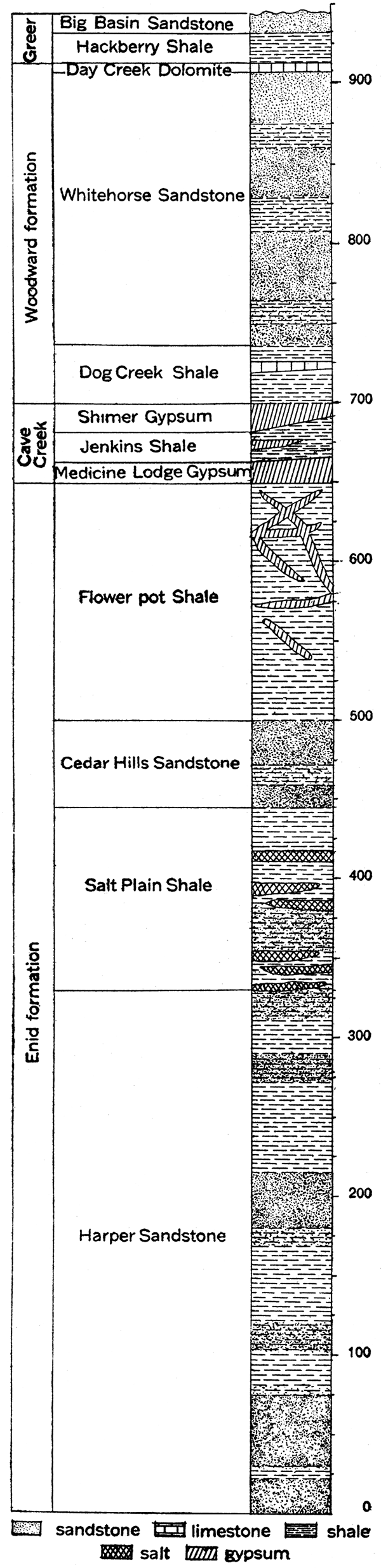
Enid Formation
[Gould, 1905, p. 39; named from Enid, Garfield county, Oklahoma.]
The lower portion of the Cimarron group from the Wellington shale to the lowest heavy gypsum bed is included in the Enid formation. Thus defined, the formation has a much greater thickness than any other division of the red beds in Kansas and covers a much larger area. It comprises essentially the non-gypsiferous portion of the group.
The outcrop of the Enid formation in Kansas covers all or portions of Sumner, Kingman, Reno, Harper, Barber and Comanche counties; but the line of division separating it from the succeeding formations has not been mapped in detail. It covers a very large area in northwestern and western Oklahoma. The formation is largely composed of red shales, but lenticular beds of soft, red sandstones occur, especially in the lower part. The thickness of the Enid formation in Kansas is about 650 feet (Cragin, 1896a, p. 20), but measurements in Oklahoma by Gould (1904, p. 40) indicate a thickness of 1,500 feet in that state. The following members are distinguished.
Harper sandstone member. (Cragin, 1896a, p. 18; named from Harper, Harper county, Kansas.) The basal part of the Enid formation, comprising almost its entire lower half, is termed the Harper sandstone member on account of exposures about Harper, Harper county, Kansas. The member is by no means wholly composed of sandstone, being largely made up of argillaceous and arenaceous shale. Both sandstone and shale are prevailingly mottled dull red or reddish brown. The sandstone beds, although soft, are sufficiently massive and firm to serve as building stone and have been quarried at Harper, Anthony and many other towns in the region. In some portions of its outcrops the beds of the Harper member are reported to be distinctly saliferous like the succeeding shale (Cragin, 1897, p. 352).
Salt Plain shale member. (Cragin, 1896a, p. 20-23; named from the Salt Plain of Cimarron river, Woodward county Oklahoma.) Red shale, largely impregnated with salt, overlies the Harper sandstone and has been called the Salt Plain shale member. According to Cragin (1896a, p. 22), the stratigraphic horizon of the shale and its outcrops at the surface are recognized by its large content of salt, which is sufficiently important to deserve the name "upper salt measures," the salt deposits of the Wellington shale being the "lower salt measures." The Salt Plain member outcrops ori the east side of the Cedar Hills, Harper county, on the Salt Fork of Arkansas river, south of Aetna, and at various points in northern Oklahoma. Beds of rock salt encountered at a depth of about 700 feet in borings at Pratt probably belong to the Salt Plain of the Enid formation. The thickness of the member is estimated by Cragin (1896a, p. 23) at 155 feet, but it is probable that the division can not be differentiated clearly at all points from adjoining parts of the Enid.
Cedar Hills sandstone member. (Cragin, 1896a, p. 24; named from Cedar hills, Harper county, Kansas.) Above the saliferous shales of the Salt Plain member is 'a zone of hard, brightred, fine-grained sandstone, which has been given the name Cedar Hills sandstone by Cragin. The member is rather massively bedded, and, according to Cragin, has locally a marked concretionary structure. Excellent exposures occur northwest of Hazelton, Kan., in the upper part of the Cedar hills, in the Gypsum hills southwest of Medicine Lodge and southeast of Aetna. The thickness of the member is about 50 or 60 feet.
Flowerpot shale member. (Cragin, 1896a, p. 24-27; named from Flowerpot Mound, between East and West Cedar creeks, Barber county, Kansas.) At the summit of the Enid formation occurs gypsiferous clay beds, named by Cragin . the Flowerpot shales, from exposures at the mound of that name in the Gypsum hills southwest of Medicine Lodge. The clay shales show variegated tints ranging from light gray to dark brown, but red is very much in predominance. Thin beds and ohliquely intersecting veins of gypsum occur throughout the member. The clays yield very readily to weathering agencies, forming many peculiar and striking erosion features. The Flowerpot shale outcrops in the escarpment of the Gypsum hills and northwestward in the bluffs of Medicine Lodge river and its tributaries to a point a few miles south of Belvidere. It is well exposed along the Salt Fork, at Cimarron and its tributaries, and extends south into Oklahoma. The thickness of the shale is about 150 feet (Cragin, 1896a, p. 27).
Cave Creek Formation
[Cragin, 1896a, p. 27; named from Cave creek, Comanche county, Kansas.]
The Cave Creek formation is the chief gypsum-bearing division of the Permian red beds in Kansas. As defined by Cragin (1896a, p. 27-28; 1897, p. 356-358), it consists typically of red shale with gypsum beds and some thin ledges of dolomite. On account of the comparative resistance of the gypsum beds to weathering agencies, the formation forms a pronounced escarpment throughout almost the entire extent of its outcrop, and is therefore easily differentiated from associated beds of the Cimarron group. In Kansas and northern Oklahoma, the Gypsum hills and Glass mountains mark this outcrop, which varies in width from one to eight miles. Excellent exposures occur on the south side of the Salt Fork of Arkansas river and Cimarron river near the state line. The outcrop of the gypsum beds trends north and northwest from southeastern Barber county to a point about 30 miles northwest of Medicine Lodge, where the Permian beds disappear beneath the Comanchean and Tertiary deposits. The thickness of the Cave Creek formation ranges from 50 to 100 feet, the average being about 70 feet. Three gypsum members, separated by red shale beds, have been distinguished in Oklahoma,146 but in Kansas only two gypsums, the Medicine Lodge bed below, and the Shimer bed above, are recognized. [Note: The equivalent of the Cave Creek formation in Oklahoma has been called the Blaine formation by Gould (1902). A thin gypsum bed, the stratigraphic equivalent of the upper Enid formation, is regarded as the base of the formation in the south, but to the north the Blaine is identical with Cragin's Cave Creek formation (Gould, 1905, p. 44). The latter name, having priority, is the one here used.]
Medicine Lodge gypsum member. (Cragin, 1896a, p. 28-39; named from exposures on Medicine Lodge river in the vicinity of Medicine Lodge, Barber county, Kansas.) The lower massive gypsum bed of the Cave Creek formation in Kansas is the most conspicuous gypsum deposit in the Permian. It is pure white to gray in color, locally with mottlings of dark reddish brown, and is very hard and fine-grained. Because of its resistance to erosion, the gypsum forms the cap rock of hills and high buttes. In many places, however, there are large solution caverns which are comparable in size and complexity to caves in limestone formations. The Medicine Lodge gypsum extends uninterruptedly from near the head of Medicine Lodge river, in Kansas, to Canadian county, southern Oklahoma, and is therefore one of the most persistent and well-defined stratigraphic horizons in the red beds. The thickness of the Medicine Lodge gypsum ranges from 2 to 30 feet (Cragin, 1896a, p. 27).
Jenkins shale member. (Cragin, 1896a, p. 28; named from the former Jenkins post office, near Cave creek, Barber county, Kansas.) Red clay shale, having a thickness ranging from 4 or 5 feet to more than 50 feet, separates the persistent gypsum members of the Cave Creek formation. It is termed the Jenkins shale member.
Shimer gypsum member. (Cragin, p. 27, 1896a; named from Shimer township, Barber county, Kansas.) The upper gypsum of the Cave Creek formation is essentially the same in physical and chemical characters as the Medicine Lodge member. Its thickness, ranging from 4 to 25 feet, is, however, not so great, but it is almost as widely distributed. A thin dolomite bed is found at the base of the gypsum in many exposures. In general the Shimer gypsum outcrops somewhat back from the brow of the hills.
Woodward Formation
[Gould, 1902; named from Woodward county, Oklahoma.]
Above the Cave Creek gypsums are found red shale, sandstone and dolomite, which have been called the Woodward formation. The formation contains no gypsum beds, its upper limit being defined by the lowest gypsum bed of the succeeding Greer formation. In Oklahoma, the W oodward is characterized by the prominence of dolomites as well as the absence of gypsum beds. The sandstones are fine-grained, and, like the shales, brilliant red in color. Where uncovered by protecting layers of harder strata, the beds are carved into very irregular and in many cases grotesque forms. The outcrop of the formation in Kansas is found in northwestern Barber county along the upper course of Medicine Lodge river, across central Comanche county, and in southeastern Clark county in the valley of Cimarron river. The general dip of the strata in this region is to the south. The thickness of the Woodward formation is about 200 to 225 feet in Kansas, but in Oklahoma it is in excess of 300 feet (Gould, 1905, p. 52). Three members are distinguished.
Dog Creek shale member. (Cragin, 1896a, p. 39; named from Dog creek, Barber county, Kansas.) The basal portion of the Woodward formation consists of dull-red argillaceous shale with one or two thin, discontinuous ledges of dolomitic limestone. This member, the Dog Creek shale, has an average thickness of about 30 feet (Cragin, 1896a, p. 39) in southern Kansas, but in central Oklahoma there is a notable increase in the proportion and thickness of dolomite (Cragin, 1897, p. 358), and measurements by Gould (1905, p. 54-55) indicate a total thickness for the member of 175 to 225 feet.
Whitehorse sandstone member. (Gould, 1905, p. 52; named from Whitehorse Springs, Woods county, Oklahoma.) The middle division of the Woodward, originally known as the Red Bluff sandstone (Cragin, 1896a, p. 40; the name Red Bluff has previously been used for another formation), comprises the largest portion of the formation. It consists of 175 to 200 feet of very fine-grained, light-red sandstone and sandy shale, irregularly stratified and cross-bedded. The Whitehorse member exhibits the most intense vivid red coloration of any division of the series. Locally the sandstone is sufficiently strong for building stone. In general it is readily eroded and forms conspicuous buttes and mesas. On Medicine Lodge river and as far west as Belvidere, the Whitehorse sandstone immediately underlies the Comanchean, but its thickness has been reduced by pre-Comanchean erosion. Outcrops are numerous along Mule creek and on Salt Fork and tributaries, in Barber and Comanche counties, north of Cimarron river, across central Clark county, and reaching to lower Crooked creek in Meade county (Cragin, 1896a, p. 43).
Day Creek dolomite member. (Cragin, 1896a, p. 44; named from Day creek, Clark county, Kansas.) The upper part of the Woodward formation in Kansas and Oklahoma is a conspicuous and persistent ledge of hard, white dolomite. Weathered exposures are gray, in many cases with a somewhat pinkish or reddish tinge. It is very compact and breaks with a conchoidal fracture like flinty chert. The thickness of the Day Creek dolomite is only 1 to 5 feet, but on account of its peculiar lithologic characters and persistence, it is a valuable horizon marker. The outcrop extends westward across north central Clark county to southeastern Meade county.
Greer Formation
[Gould, 1902; named from Greer county, Oklahoma.]
Above the Day Creek dolomite in southwest Kansas, are 25 to 40 feet of red shale and sandstone which are with little doubt the stratigraphic equivalent of the Greer formation of Oklahoma, the upper gypsum series of that state. The exposed rocks of the uppermost Permian in Kansas do not contain gypsum. The outcrop of the formation is found in Clark county, exposures specially noted by Cragin (1896a, p. 46-48) occurring near the junction of Bluff and Hackberry creeks, Kiger creek and Bear creek. Rocks observed on Crooked creek, in southeastern Meade county, may belong to this horizon (Cragin, 1896a, p. 47). It is to be noted that a considerable thickness of Permian red beds, younger than the probable representative of the Greer formation in Kansas, is exposed in western Oklahoma. [Note: The gypsum-bearing Greer formation and the succeeding Quartermaster formation in Oklahoma, both of Permian age, have a combined thickness of 500 to 600 feet. (Gould, 1905, p. 59, 72.)] An unknown thickness of Permian strata has been removed by the erosion which preceded the Comanchean depositions in Kansas. It is possible that a greater amount of the upper red beds are present beneath the covering of younger sediments in the western part of the state than are exposed in the area of Permian outcrop. The Greer formation in Kansas includes two members, as distinguished by Cragin.
Hackberry shale member. (Cragin, 1896a, p. 46; named from Hackberry creek, Clark county, Kansas.) The lower member of the Greer consists of maroon-colored shale, which characteristically weathers into small crumbling fragments. Its exposed thickness is not more than 20 feet.
Big Basin sandstone member. (Cragin, 1896a, p. 46; named from Big Basin, Clark county, Kansas.) Above the Hackberry shale is a rather massive sandstone, red or grayish white in color. It is exposed at a number of localities in Clark county, where on the west it underlies the sandstone of the Comanchean. Its maximum measured thickness is 12 feet.
Comanchean System
Appearing at the surface in Barber, Comanche, Kiowa, Clark and Meade counties, Kansas, and continuing thence in a southwesterly direction into Oklahoma, is a not very thick succession of sandstone and shale beds which by their contained fossils appear to represent some portion of the well-developed Comanchean system of the Texas region. The belt of outcrop of these beds pursues an irregular westward course on the north side of Medicine Lodge river from a point a few miles northeast of the town of Medicine Lodge into southeastern Kiowa county, southeastward a considerable distance on the south side of Medicine Lodge river, then turns west. An outlier covering some square miles is found in southern Comanche county. The northward extent of the Comanchean beds is undetermined on account of the widespread cover of younger strata. Scientific interest attaches to the discovery of fossiliferous beds resembling the Comanchean in northern McPherson and Saline counties along Smoky Hill river. The age and the general character of these, the socalled Mentor beds (Cragin, 1895a, p. 162), are not satisfactorily determined.
Figure 23—Generalized section of the Comanchean and Cretaceous systems in Kansas.
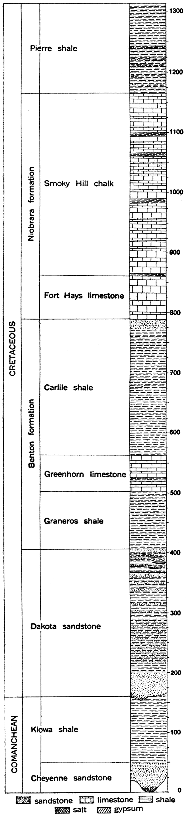
The Comanchean of southwestern Kansas is composed of two formations, which may be distinguished readily both by lithologic and paleontologic characters. At the base, resting with distinctly marked unconformity on the eroded surface of the subjacent Permian red beds, is a sandstone which varies in thickness from 40 to 70 feet. This division has been called the Cheyenne sandstone (Cragin, 1889, p. 65-68; named from the Cheyenne rock at Belvidere, Kiowa county, Kansas), The upper division consists of calcareous shale 125 to 140 feet in thickness, which in the eastern portion of the Comanchean area, in Kansas especially, passes at its base into a shelly, fossiliferous limestone. The formation is termed the Kiowa shale (Cragin, 1894, p. 49; named from Kiowa county, Kansas). In the eastern portion of its outcrop it rests on the Cheyenne sandstone. Farther west it immediately overlies red beds of the Permian Cimarron group. Above the Kiowa shale is found brown sandstone of Dakota age, or Tertiary and Pleistocene sand, gravel and other deposits.
The total thickness of the Comanchean beds as observed in southwestern Kansas is not, then, more than 300,feet, and throughout the greater portion of its extent, the division has an average thickness of less than 200 feet. It is probable that within a few miles to the north these beds pinch out entirely.
Careful studies made by Cragin (1890, vol. 6, pp, 233-238, vol. 7, pp. 23-33; 1891, p. 179-181; 1894, p. 49-68; 1895b, p. 357-385), Hill (1895, p. 205-234), and Prosser (1897c, p. 96-181) indicate that the Comanchean beds of Kansas should be regarded as the attenuated equivalent of the uppermost or Washita division of the Texas Comanchean.
Cheyenne Sandstone
The Cheyenne sandstone is the lower, sandy division of the Comanchean rocks in southwestern Kansas (Fig. 21). It is found chiefly in the eastern part of the Comanchean area, being undeveloped, for the greater part, in Clark and Meade counties, where the Kiowa shale rests directly on the Permian red beds. The Cheyenne formation is in the main a rather coarsegrained, friable sandstone, yellowish gray to whitish in color, but in many exposures spotted and striped with colors such as purple, crimson or brown. In places it is conspicuously cross-bedded. Some layers in the formation are more firmly cemented than associated ones and stand out prominently on weathered exposures. The outcrop is characteristically rugged and carved by erosion into various forms: Fossil wood and imprints of leaves resembling leaves from the Dakota sandstone are found at different localities in the Cheyenne. The maximum observed thickness of the formation is about 70 feet (Prosser, 1897c, p. 112), but its average ranges from 40 to 55 feet.
Kiowa Shale
The upper portion of the Kansas Comanchean consists of shaly material. The rocks composing this, the Kiowa shale, are as widely distributed in the state as the Comanchean, and are found in places overlying the Cheyenne sandstone, elsewhere resting directly on the Permian red beds. Over a large area there is found at the base of the formation a very calcareous zone filled with invertebrate fossils. This, called by Cragin (1895b, p. 368) the Champion shell bed, is essentially a limestone member and is regarded as the probable equivalent of the Comanche Peak limestone of Texas (Cragin, F. W., letter to Charles S. Prosser, 1897c, p. 114).
Above the fossiliferous calcareous zone is black, laminated, argillaceous shale which gradually changes upward to bluish and grayish, slightly arenaceous shale. The upper part of the formation consists of fossiliferous yellowish-gray shale with thin layers of yellowish or pinkish limestone. The maximum thickness of the Kiowa shale is 150 feet, measured on Bluff creek in Clark county (Cragin, F. W., letter to Charles S. Prosser, 1897c, p. 115), the average being about 125 or 130 feet.
Cretaceous System
General Description
Distribution. Occupying an area of nearly 25,000 square miles in north central Kansas, and appearing at the surface in smaller tracts at various places in the western part of the state, are strata belonging to the Cretaceous system. The eastern boundary of the Cretaceous outcrop is a very irregular line trending southwest from Washington county to Reno county. Important outliers occur in Saline, Dickinson, Marion and McPherson counties. To the south and west the Cretaceous is concealed by a widespread mantle of Tertiary sands, gravels and other deposits. Along many of the streams, however, especially the main lines of drainage, the Tertiary cover has been removed by erosion, exposing the Cretaceous in long, narrow arms. Along Smoky Hill river, for example, Cretaceous strata are exposed to the west beyond the Colorado state line. The small areas of Cretaceous outcrops surrounded by Tertiary, which occur both to the north and south of the Smoky Hill, are found mainly where streams have cut through the overlying Tertiary.
Thickness. The maximum thickness of the Cretaceous rocks in Kansas is probably not more than 1,300 feet, but since the uppermost formation, the Pierre shale, is restricted to the northwestern portion of the state, it is certain that the thickness of the Cretaceous in the main area of its outcrop is very much less. In general, greater thicknesses are to be measured proceeding to the west, where successively higher divisions of the system are encountered. The thickness of the individual formations appears to remain fairly constant, so that measurements made at the outcrop closely approximate the record of thickness obtained from well-logs a hundred or more miles distant. The average thickness of the Cretaceous formations in Kansas is shown on the accompanying generalized section (Fig. 23).
Lithologic Character. The Cretaceous system is composed of clayey and sandy shale, chalky limestone and sandstone, named in the order of their quantitative importance in the section.
The shales are, for the most part, rather dark in color, ranging from dark blue-gray or brown to black. The "somber" color of some of the Cretaceous shale divisions is a characteristic feature throughout the entire Northwest. Some of the shale beds are bituminous and contain thin beds of lignite. Light-gray to almost white shales are well developed locally.
The limestone strata of the Cretaceous are in most cases characterized by their peculiar chalky texture. In some localities the rock is a pure chalk, white to light gray in color, and composed almost wholly of the microscopic remains of lime-shelled Foraminifera. From the purer varieties there is every gradation to chalky shale or calcareous sandstone. Some of the limestone is hard and resistant, but in general it is much too soft for use in building. Colors observed include light blue, lavender, yellow, buff and light red. In a few places the chalky limestone beds contain concretions of flinty chert. A variety of other concretions are also observed.
The sandstone of the Cretaceous in Kansas belongs chiefly to the basal division, the Dakota. The Dakota sandstone is a coarse-grained, rather loosely cemented, massively bedded formation, gray to light or dark brown in color. As observed in many exposures it is very much cross-bedded. The chief cementing material is calcium carbonate, but iron oxide is also abundant, the content of iron being so great at some weathered exposures that the color is changed to a very dark brown and the weight of the rock is perceptibly increased. Where the rock is firmly cemented, it is very hard and resistant, but other portions of the formation are soft and crumbling. As a rule, the rock is very porous and presents most favorable conditions for the storage of underground water. Sandy beds, which occur higher in the system, as in the Carlile shale, are finer in their average texture and lighter colored than the Dakota.
Effect on Topography. The topography of the Cretaceous area is essentially similar in many respects to that of the Pennsylvanian and Permian area farther east. The most prominent topographic features of eastern Kansas are the series of north-south escarpments formed by hard limestone members which alternate with soft, easily eroded shale members. In the area of Cretaceous outcrop there are also horizons which offer relatively great resistance to agencies of erosion, and, as in the Pennsylvanian area, more or less prominent escarpments are formed. However, the Cretaceous escarpments are in general less persistent and clearly defined. The divides between streams are rather characteristically broken up into buttes and isolated hills. The east margin of the Dakota sandstone is especially marked by rough, craggy buttes. Shale areas in the Cretaceous belt, especially that of the Pierre shale, are marked in some districts by more or less numerous symmetrical "tepee buttes," hills of shale capped by large concretions or other resistant portions of the rocks.
Structure. As shown by Logan (1897, p. 205-206), and as indicated in the structure-contour map, Plate XXVI, the general dip of the Cretaceous formations in Kansas is to the northeast. The dip is very gentle, amounting to an average of about 5 to 7 feet per mile, and appears to be constant for considerable distances. As determined by Darton (1905, p. 191), chiefly from well records, the Cretaceous of northwestern Kansas dips to the north and northwest, a broad, gentle anticline with a north- and south-trending crest being found close to the line between Decatur and Norton counties. (Plate XXVI:) Similarly a slight anticlinal bulge is indicated in Ford and Hodgeman counties. A more clearly defined structural feature is found near the western border of the state, south and southwest of Coolidge, Hamilton county.
Subdivisions. On the basis of lithologic character and fossils, the strata of the Cretaceous have been divided into a number of formations and members. The classification of the system as developed in Kansas agrees closely with that generally adopted in the Great Plains province. The names used in this report are those which appear to belong most appropriately with the subdivisions in Kansas and which accord most closely with established rules of priority.
| Divisions of the Cretaceous Rocks in Kansas | |
|---|---|
| Pierre shale | Undifferentiated |
| Niobrara formation | Smoky Hill chalk member |
| Fort Hays limestone member | |
| Benton formation | Carlile shale member |
| Greenhorn limestone member | |
| Graneros shale member | |
| Dakota sandstone | Undifferentiated |
Dakota Sandstone
[Meek and Hayden, 1862, p. 410, 420; named from Dakota territory (1861), which included the present states of North and South Dakota and portions of Wyoming and Montana.]
The Dakota sandstone appears at the surface in a rather narrow but extremely irregular zone, which extends from Washington county south and southwest to Arkansas river in Rice and Barton counties, and up the Arkansas to Ford county, where it disappears beneath the Tertiary deposits. The formation reappears in a number of places along Cimarron river and its tributaries in the extreme southwestern corner of the state. To the northwest the Dakota sandstone passes beneath the higher formations of the Cretaceous, extending, deeply buried, far beyond the state boundaries. It is sharply upturned with other sedimentary beds on the east flank of the Rocky Mountains in Colorado. (Plates XII and XIV.) In northwestern Kansas it probably lies more than 2,000 feet below the surface. In the northern counties the Dakota rests on the dark shales of the Wellington formation, to the south on red strata of the Cimarron group. The equivalent of the Dakota in southwestern Kansas is found overlying the eroded Comanchean deposits.
Plate XIV—Wall of Dakota sandstone west of Trinidad, Colo. Outcropping edge of sandstone upturned on east slope of Rocky Mountain uplift. (U. S. Geol. Survey.)
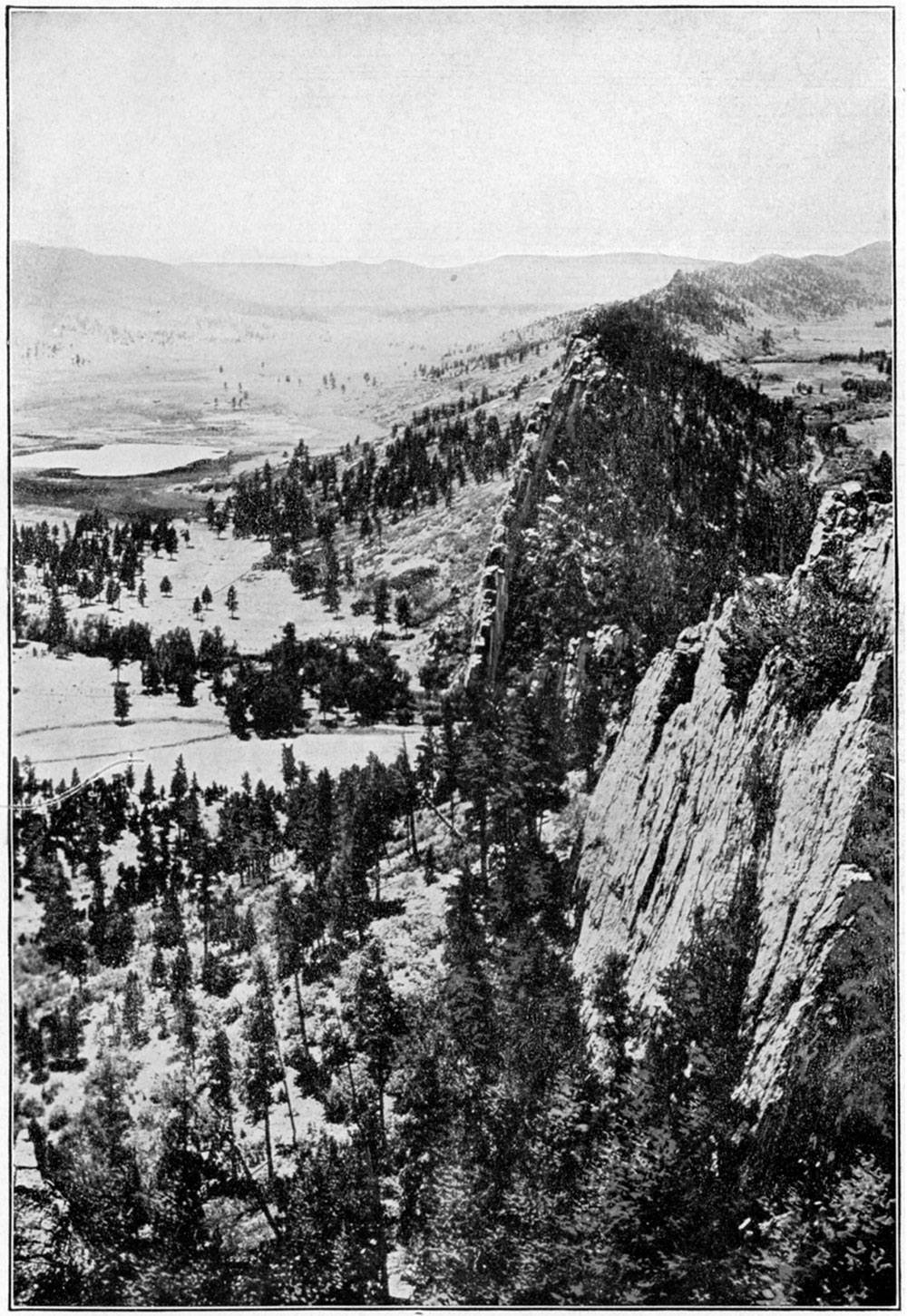
While the Dakota is chiefly a sandstone formation, there are important associated shale deposits at this horizon in Kansas. The shale, although considerable in extent, is so variable in its relation to the sandstone that stratigraphic division is not possible. As defined by Logan (1897, p. 207-209) from extensive observations along the outcrop of the Dakota, there are two main divisions of the formation in central Kansas—a lower portion, 150 feet or more thick, consisting of massive sandstone alternating with variously colored shale; and an upper portion, 35 to 50 feet thick, containing lignite and more or less abundant salt and gypsum. The total thickness of the Dakota ranges from 200 to more than 300 feet (Darton, 1905, p. 152).
Plate XV—The Great Plains of western Kansas. Smooth and almost level, sloping gently upward to the west. In this portion of the stnte there is no surface evidence whatever of underground structure.
Benton Formation
[Meek and Hayden, 1862, p. 410, 421; named from Fort Benton, Mont.]
The Benton formation consists of shale with intercalated limestones and sandstones. Its outcrop is a wide belt of rather gently undulating country extending diagonally across the state from Republic and Washington counties at the northeast to Ford, Hodgeman and Finney counties in the southwest. Here the Benton disappears beneath the Tertiary, but it reappears along the valley of Arkansas river in Kearny and Hamilton counties. The thickness of the formation is somewhat variable, but it averages about 400 feet.
Three main stratigraphic subdivisions are included in the Benton formation of Kansas-from the base upward, respectively, the Graneros shale member, the Greenhorn limestone member, and the Carlile shale member.
Graneros shale member. (Gilbert, G. K., 1896, p. 564; named from Graneros, Pueblo county, Colorado.) The basal portion of the Benton is a dark clay shale varying in thickness from 20 or 30 feet (Logan, 1897, p. 216) to nearly 200 feet (Darton, N. H., 1915, p. 44). In central Kansas this member, which from exposures in Colorado has been called the Graneros shale, is rather bituminous, hard and slaty, and on weathering breaks into thin flakes. Here it is not very thick, but in the valley of Arkansas river toward the western border of the state it is a very important division.
Greenhorn limestone member. (Gilbert, G. K., 1896, p. 564; named from Greenhorn, Pueblo county, Colorado.) The middle portion of the Benton formation, throughout Kansas and eastern Colorado, is composed of calcareous beds, including limy shale, soft chalky limestone, and thin beds of hard, resistant limestone. This division, 40 to 60 feet in thickness, is termed the Greenhorn limestone. The basal part of the member, about 15 feet thick ("Lincoln marble" of Logan (1897, p. 216)), is made up of bluish-gray, hard, flinty but easily weathering limestone, in beds less than 6 inches thick, alternating with shale. About 16 feet of white or light cream-colored, fine-grained, thin-bedded limestone ("Flagstone" horizon (Logan, 1897, p. 216)) follows, and is overlain in turn by 40 feet of limy shales and thin beds of limestone filled with impressions of the fossil shell Inoceramus labiatus ("Inoceramus" horizon (Logan, 1897, p. 216)). The top of the Greenhorn member is marked by a stratum of limestone about 9 inches thick which breaks characteristically into long, angular pieces somewhat like fence posts ("Fencepost" horizon (Logan, 1897, p. 216)).
Carlile shale member.(Gilbert, G. K., 1896, p. 565; named from Carlile, Pueblo county, Colorado.) The uppermost portion of the Benton formation in Kansas consists almost entirely of shale, which from Colorado exposures has been called the Carlile shale member. The lower portion of the shale, about 100 to 150 feet in thickness, is a soft clay shale, dark bluish gray in color. It contains occasional thin beds of limestone and is very fossiliferous, containing especially enormous numbers of fossil oysters ("Ostrea shales" (Logan, 1897, p. 220-221, pl. 27)). The upper part of the Carlile member is an unfossiliferous, loose-textured blue gray shale, characterized by the occurrence in its upper portion of numerous concretions. The concretions are lens-shaped, and vary in size up to 4 or 5 feet in diameter. They are dark colored, and are solid carbonate of lime or hollow geodes lined with calcite crystals.
Niobrara Formation
[Meek and Hayden, 1862, p. 419, 422; named from Niobrara river, Nebraska.]
The Niobrara formation, comprising the main calcareous portion of the Cretaceous system in Kansas, underlies the entire northwestern part of the state. Its outcrop is a wide area trending southwest from Jewell county to Finney county, marked at its eastern margin by a series of slopes which rise above the rolling topography of the Benton formation. To the west the Niobrara is thickly covered by deposits of Tertiary age, but along the larger streams, notably Smoky Hill river, the Tertiary has been cut away, making extensive exposures of the subjacent Niobrara. The thickness of the Niobrara formation ranges from about 350 feet (Logan, 1897, p. 220-221, pl. 27) to 650 feet (Darton, 1905, p. 155), the average being somewhat nearer the lower figure. On lithologic as well as faunal grounds, a division of the Niobrara formation is made in Kansas.
Fort Hays limestone member. (Mudge, 1876, p. 218-221; named from the former Fort Hays, Ellis county, Kansas.) The lower portion of the Niobrara, having an average thickness of 50 feet, is the Fort Hays limestone member. The limestone is a soft, massive, light-colored rock, sufficiently resistant to erosion to weather out in bluffs of some prominence. In well borings, it is distinguished in most cases from associated members by its greater hardness. The outcrop of the Fort Hays limestone member extends along the margin of the Niobrara area from Jewell county to Finney county and up Smoky Hill river into Gove county. It is also observed in central Hamilton county north of Coolidge and at other points north of Arkansas river.
Smoky Hill chalk member. (Cragin, 1896b, p. 51; named from Smoky Hill river, Kansas.) The upper division of the Niobrara, termed the Smoky Hill chalk member, comprises much the thicker portion of the formation, having a total thickness ranging from 300 to 350 feet. In an unweathered condition the chalk is a massive, light bluish, gray, clayey rock, but on weathering, the color changes to yellow or buff, or in some cases light red on account of the oxidation of iron contained in the deposit. Surface waters serve to leach out the oxidized iron and other coloring matter in many places, leaving the chalk rock bleached and white. In well borings the member appears in most cases as a pale-blue chalky clay, which is only slightly sticky when wet. Some rather pure chalk is found locally in the Smoky Hill member, as near Norton. The best exposures of the chalk are found in the valley of Smoky Hill river, where prominent buttes and castellated cliffs mark the outcrop.
Pierre Shale
[Meek and Hayden, 1862, p. 419, 424; named from Fort Pierre, now Pierre, S. Dak.]
The northwest counties of Kansas are underlain by the Pierre shale, the uppermost division of the Cretaceous in this region. The Pierre is covered by deposits of Tertiary for the greatest part, but outcrops appear in Cheyenne county, along Beaver and Sappa creeks in Rawlins and Decatur counties; on Prairiedog creek, southwest of Norton county, and over a large area on Smoky Hill river and tributaries in Wallace and Logan counties. The shale is somber, dark bluish-gray in color, but weathers to a brownish tint. The formation is soft and clayey, yielding readily to agencies of erosion. Some beds contain rather numerous lensshaped concretions which contain distinctive marine fossils. The maximum thickness of the Pierre shale in Kansas is not more than 200 feet (Logan, 1897, p. 221).
Tertiary and Later Deposits
The greatest part of western Kansas, comprising an area thousands of square miles in extent, is covered by a mantle of sand, gravel and limy clay which appears to have been deposited in late Tertiary time. This widespread Tertiary deposit forms the capping of the so-called High Plains, and extends for great distances over eastern Colorado and western Kansas and Nebraska. The name Ogalalla formation, from a locality in southwestern Nebraska, has been adopted for this portion of the Tertiary (Darton, N. H., 1898, p. 734; named from Ogalalla, Keith county, Nebraska).
Ogalalla Formation
The Ogalalla formation, as indicated by present field investigations, occupies all of the High Plains (Plate XV) of western Kansas. Its eastern boundary is a very irregular line trending southwestward from Jewell county to Finney county, thence eastward to Reno county, where it turns again to the southwest into Clark and Meade counties. The formation extends farthest east along the divides between the main streams. The larger rivers have cut through the Tertiary and carried away the sand and gravel from large areas. In some instances, notably the valley of Smoky Hill river, the Ogalalla has been removed for long distances; but in others, as along Cimarron river and tributaries in southwestern Kansas, it has been cut away only locally (Plate I).
The materials of the Ogalalla formation are mainly sands, gravelly sands and gravels more or less cemented by carbonate of lime Into a grit rock which in many cases has the appearance of rough mortar. On account of this resemblance, the name "mortar beds" has been rather widely applied to portions of the Kansas Tertiary (Haworth, 1897a, p. 22, 25, 32, etc.; Haworth, 1897b, p. 258-260). The deposits are in general calcareous, in some cases consisting-mainly of lime carbonate and containing but little sand. In places, the formation is a light-colored sandy clay containing much carbonate of lime in streaks or nodules. The gravels found in the Ogalalla formation and derived by its weathering contain pebbles varying in size from 4 or 5 inches in diameter to coarse sand. They are composed of granite, syenite, porphyry, basalt and other igneous rocks and are evidently derived from areas of crystalline rocks to the west. Quartz pebbles are common. The sand is merely the finer material derived from the weathering of igneous rocks, but is largely a pure quartz sand. It exhibits various degrees of fineness, but when examined closely the grains are in almost all cases well rounded. Accumulations of small pockets of black magnetite sand are not uncommon in many parts of the Ogalalla (Haworth, 1897b, p. 255). Clay beds are commonly white or pinkish and in some places form low but steep banks or cliffs along the headwaters of streams. In a few localities, especially Norton and Phillips counties, beds of volcanic ash a number of feet in thickness occur. They are evidently related to similar deposits which have been found over a considerable area in Nebraska (Darton, 1898, p. 760-761) and Oklahoma (Buttram, 1914). Volcanic ash does not constitute an important part of the Kansas Tertiary deposits.
The thickness of the Ogalalla formation in Kansas varies from practically nothing to more than 300 feet. Throughout the largest part of western Kansas it averages from 150 to 200 feet. In general the records of wells which have been drilled through the formation indicate that the greatest thicknesses are found on broad, flat divides which have been little affected by erosion.
There are no well-defined stratigraphic horizons in the Kansas Tertiary which can be traced over considerable areas in an investigation of the structure of these beds. Prominent "mortar beds" which are well developed in some regions can not be traced with sufficient accuracy or to a sufficient distance to be of great service. Also, these distinctive portions of the Tertiary are found at the base, in the middle or at the summit of the formations in different localities. Since, however, a very large portion of the area underlain by the Ogalalla is an almost featureless plain, it is in general very difficult to determine in any satisfactory way the structural relations of the Tertiary.
Numerous remains which have been found in the Ogalalla formation in Kansas, indicate that it should be referred to the Pliocene epoch of Tertiary time, and the deposits are so correlated by Darton (Darton, 1905, p. 150), but it is possible that at least in part the beds are upper Miocene in age.
Quaternary Deposits
Deposits made during the Glacial epoch and in recent geologic time are found in various parts of the state. They are of importance to the petroleum geologist and producer because of their relations to the underlying consolidated strata, which must be studied carefully in any scientific exploration for oil or gas. In some cases these deposits only partially obscure the structure of the subjacent rocks, but in others they conceal it entirely. The deposits in Kansas which are referred to the Quaternary (Plate XVI) include (a) glacial deposits, (b) Pleistocene river deposits, (c) loess, (d) alluvium, and (e) sand hills.
Plate XVI—Outline map showing distribution of chief Quaternary deposits in Kansas.
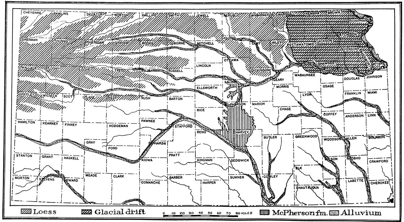
(a) Glacial Deposits. The former existence of a large glacier which advanced from the north and covered a large area in the northeastern portion of the state is evidenced by widespread deposits of glacial drift, bowlders and other glacial materials which entirely cover the region north of Kansas river and east of Washington and Riley counties (Plate XVI). The glacial drift is a heterogeneous mixture of clay, sand, pebbles and bowlders which is found on the hilltops as well as in the valleys. The drift was deposited beneath and at the margin of the "Kansan ice sheet," one of the earliest of the continental glaciers which during the Pleistocene covered enormous areas in the United States. The drift is very much weathered and thoroughly oxidized, so that the color due to the iron oxide content is in most cases a rich brown or red and the pebbles and bowlders are decayed and soft. Sufficient time has elapsed since the glaciation of northeastern Kansas to permit considerable stream erosion. Lakes and swamps which are so numerous in recently glaciated districts are therefore absent, and the general appearance of the country resembles somewhat non-glaciated portions of the state. In some places, the drift and other deposits made by the glacier have been removed by erosion, exposing the underlying hard rock strata, but for the greater part, the mantle of glacial material effectually covers the underlying bed rock and obscures its structure. Lake deposits of glacial origin have been identified by Professor Todd at various points along the margin of the Kansan glacier. The thickness of the glacial drift is on the average not greater than 6 to 10 feet, and in many places it is practically absent, but locally, as shown by well-borings, there are accumulations of more than 60 feet (personal communication from Prof. J. E. Todd).
(b) Pleistocene River Deposits. During the Pleistocene, or Glacial Period, considerable deposits of sand, sandy clay and alluvium were made in various stream valleys of the state. In some cases the material deposited may have been derived from the continental glacier to the north, but in large part the deposits were evidently obtained by normal erosion processes from the drainage basins of the streams themselves. Extensive deposits of this sort are found along the course of Arkansas river, Kansas river and tributaries.
One of the most interesting of the river deposits of Pleistocene time in Kansas is found in McPherson, Marion, Harvey and Reno counties (Plate XVI). This deposit, which has been called the McPhersen formation (Haworth and Beede, 1897, p. 287-296; named from McPherson, McPherson county, Kansas), is found in a broad channel, carved in the upper Permian shales and the Dakota sandstone, and extending from Smoky Hill river at the north to Arkansas river in Sedgwick county. The area covered comprises practically the entire eastern half of McPherson county south of a line drawn from Lindsborg to Canton, all of Harvey county west of Newton and most of eastern Reno county. The material composing the deposit consists of irregular layers of sand, clay and gravel, cemented loosely by carbonate of lime. The sand and gravel contain an abundance of water, and supply the water plants of neighboring cities. The thickness of the formation varies from a few feet to more than 100 feet.
(c) Loess. Covering a wide area of the High Plains between the valleys of northern and northwestern Kansas is a smooth-surfaced, thick mantle of loess (Plate XVI). According to Darton (1905, pl. 44), the border of the loess-covered area trends eastward from Greeley county to Ellis county, thence northward to Osborne county and northeastward to Republic and Washington counties. There are also thick deposits of loess throughout northeastern Kansas in the district covered by the glacial drift. There are no sharp boundaries to the region of loess deposits because of the presence of the loess only on the uneroded uplands. In the west in few cases does it exceed a thickness of 30 to 40 feet, and on the average it is very much less, but in the northeastern counties of the state the thickness is in general much greater. In some places near Missouri river, the loess is more than 100 feet thick.
(d) Alluvium. There are many wide valleys in Kansas which are filled to various depths with deposits of alluvial material brought down by the streams. The largest and most extensive of these river deposits is that along the Arkansas river valley, which has a width of 6 to 10 miles and crosses a considerable part of the state. Other large streams such as Kansas river and its tributaries to the west, Republican, Solomon, Saline and Smoky Hill rivers, have wide flood-plains composed of rivermade alluvium. All the river and creek valleys contain more or less alluvial material of relatively recent origin, and most of the lower slopes of hills are covered by talus and slope-wash derived from recent weathering. The deposits, which are mainly sands and loams intermixed locally with gravel, are important to the petroleum producer because of their widespread covering of rock outcrops. An excellent example is found in the Walnut river valley in southern Butler county, Some of the most productive wells and valuable leases in this district are located on the wide river bottom where there are no rock exposures and practically no indication from surface evidence of the anticlinal structure of the rocks underground which controls the accumulation of the oil.
(e) Sand Dunes. A wide area in central Kansas, chiefly on the south side of Arkansas river, from Ford to Reno counties, is occupied by windblown sand. The sand constitutes hills and ridges of moderate height, with irregular basins and flats intervening. The sand has been derived chiefly from the alluvial flats along Arkansas river, being blown out by the winds, which are prevailingly from the northwest. Indirectly, much of the sand comes from the weathering of the Dakota sandstone and Tertiary deposits in the region. The dune sand effectually covers the bed rock and makes impossible any determination of the rock structure from surface evidence. The area occupied by the sand, therefore, can be prospected only by "wild-cat" methods,
Plate XVII—Map showing location of geologic sections A-H, plates XVII-XIX.
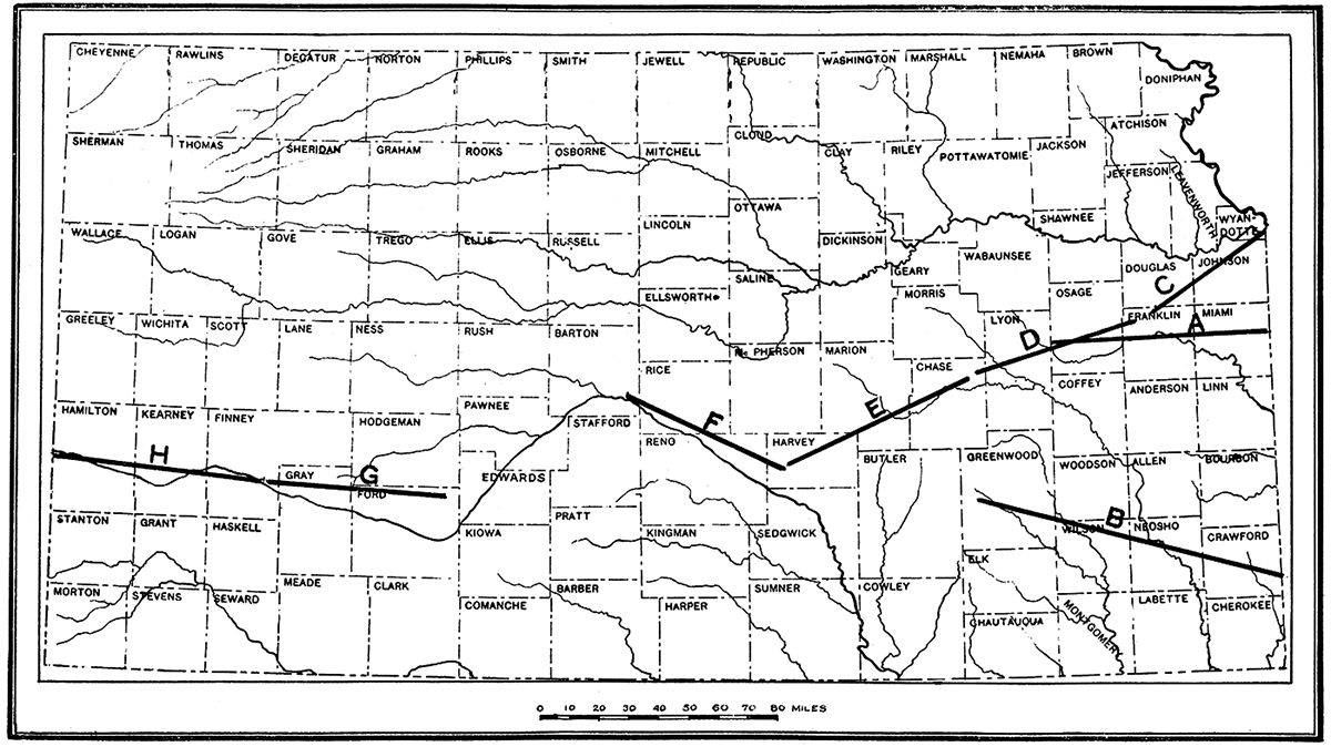
Plate XVIII—A. Section showing underground relations of rocks from the state line east of Paola to a point about ten miles west of Osage City. Vertical scale greatly exaggerated. This has the effect of increasing apparent tilt of beds. All cross sections available in an Adobe Acrobat file.
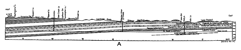
Plate XVIII—B. Section showing underground relations of rocks from the state line east of Fort Scott to Burlington.
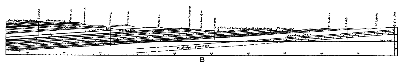
Plate XIX—C. Section from Kansas City through Olathe and Baldwin along line of old Santa Fe trail.
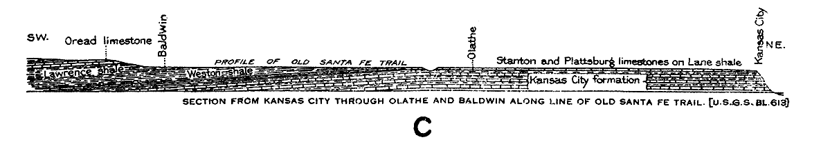
Plate XIX—D. Section from Pomona to point west of Emporia.
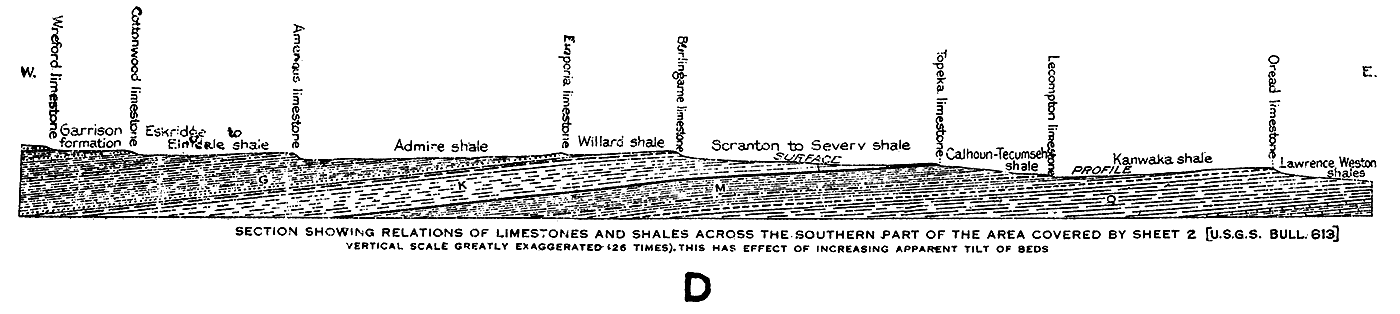
Plate XIX—E. Section from Strong City to Halstead, Kan.
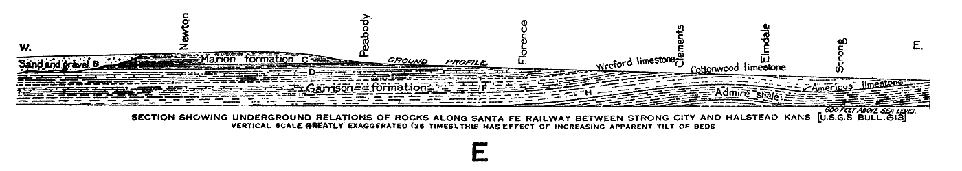
Plate XX—F. Section from Paxton to Ellinwood, Kan.
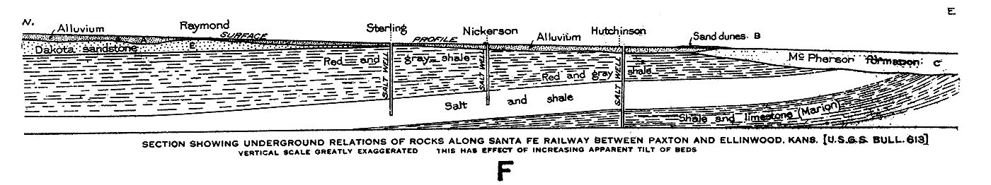
Plate XX—G. Section from Spearville to Mansfield, Kan.
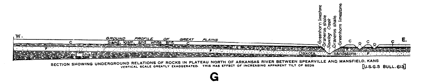
Plate XX—H. Section from Garden City to Medway, Kan.
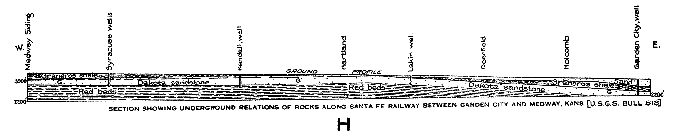
Prev Page--Production || Next Page--Crystalline Rocks
Kansas Geological Survey, Geology
Placed on web Aug. 10, 2018; originally published 1917.
Comments to webadmin@kgs.ku.edu
The URL for this page is http://www.kgs.ku.edu/Publications/Bulletins/3/07_strat.html