![]()
Prev Page--Petroleum and Natural Gas || Next Page--Production
Chapter IV—General Geology of Oil and Gas
Introduction
The fundamental importance of geology as applied to the location and development of commercial deposits of oil and gas has now been so thoroughly demonstrated that it is entirely unnecessary to consider the relationship here. Geology is a common-sense scientific investigation of the earth, including the materials of which it is composed, the processes which work to form or modify it, and the history of its development. This study has definitely proved many things and offers assistance of highest value to the oil operator or producer. The "practical" oil man who does not utilize the information which geologic science is now able to offer is not equipped to engage in the business, and in the case of an officer of an oil company might well be considered guilty of misappropriation of funds.
[Note: It should be mentioned that owing to the growing demand for geologic knowledge concerning oil and gas possibilities in various districts, numbers of poorly trained, incompetent or absolutely ignorant men have represented themselves as geologists and have readily deceived those not acquainted with the facts Dr methods of the science. The work of such inadequately trained or fake "geologists" is unreliable and has done great ha rm to the professional reputation of competent geologic engineers. Fortunately there is at present a better genera] understanding of the requirements of the geologist and the opportunities for those not qualified to do geologic work are becoming limited. In general, a person desiring reliable work may secure it by employing any geologist who has been connected with some official surveyor recognized institution and who can offer suitable credentials as to the character of his training and experience. Warning may also be given with regard to the advertisements of stock made by certain unscrupulous oil companies which claim the very favorable report of a geologist. Of course, such recommendations can be secured without difficulty from an unprincipled "geologist."]
The following discussion of the general geology of oil and gas presents only the most important considerations bearing on the movement of oil and gas through the rocks, their accumulation at certain places in the rock strata and the methods of locating the accumulations. It is made with special reference to the conditions obtaining in the Midcontinent field.
Migration of Oils and Gas
Whatever may be the source of petroleum and natural gas, and whatever the character of reactions which operate in their production, it is almost certain that they first appear in a state of dissemination. If this is true, question must be raised as to the conditions which have caused them to move through the rocks and to accumulate in the pools of varying size which have been encountered in drilling. These problems will be considered before discussing the geological occurrence of oil and gas.
The movement of oil and gas through the rocks seems referable to five main causes. These are (1) gravitation, (2) capillary attraction, (3) displacement, (4) gas pressure, and (5) difference in specific gravities.
(1) Oil and gas, in common with all other substances, are affected by gravitation, but due to the intervention of more powerful forces it operates as a cause of migration only under conditions in which other agencies are inactive. Gravity is not effective in producing a movement of gas, but where the rocks are dry and sufficiently porous it may cause a downward migration of oil. The oil is pulled through the pores of the rocks until the space between the grains of the rock becomes too narrow, or water is encountered. The movement of oil under the influence of gravity is, however, weak, and probably has played a very small part in the great migration of oil which has produced the large oil pools.
(2) Capillary attraction is effective in producing movement of oil, and is probably a much more important agent than gravitation. Capillarity, which may be illustrated by the absorption of ink in the fine pores of a blotter or the rise of kerosene in a lamp wick, affects all liquids. The amount of movement of oil in the rocks due to capillarity depends on the material of the rocks, the diameters of the pores, and the temperature. Day (Day, David T., The conditions of accumulation of petroleum in the earth: Am. Phil. Soc. of Phila. Proc., vol. 36, pp. 112-155. 1897; also, Am. Inst. Mill. Eng., Trans., vol. 41, pp, 212-224, 1910.) has shown that petroleum will diffuse readily in all directions through dry clay and shale, the oil becoming separated in the diffusion into fractions of different specific gravities. The migration of the oil depends on the extremely small size of the pores, the amount of attraction being inversely proportional to their diameter. Movement ceases where the diameter of the pores becomes too great. In the absence of water, capillarity will draw the oil into the fine pores and will probably not operate to produce any considerable migration of the oil. The differential capillary attraction of oil and water is, however, as shown by Washburne (Washburne, C. W., The capillary concentration of gas and oil: Am. Inst. Min. Eng., Bull. No, 93, pp. 2365-2378, 1914; also,Dorsey Hager, Capillarity, Practical oil geology, pp. 8-9, 1916.), an important factor in causing movement. Since water has a surface tension almost fifty percent higher than that of oil, it tends to be drawn into the fine openings in the rocks with a correspondingly greater force than that of oil and gas. The water, therefore, moves with more readiness from sandstone to shale than in the reverse direction, while gas and oil tend to move in the opposite way. The net result is the concentration of the gas and oil in the coarsest available spaces in the rocks. As shown by experiment (Day, David T., loc. cit.), water-wet shale is practically impervious to oil and gas, and is therefore admirably fitted to serve as a cap rock, holding oil and gas which have accumulated in a porous rock beneath. Capillarity is doubtless effective in moving oil and gas from the less to the more porous rocks, but is probably not an important factor in the broad migration of these fluids.
(3) An effective cause of the migration of oil and gas is the displacement of these materials by agencies which drive them from places previously occupied to new positions in the rocks. One of the most important agencies of displacement is the compacting of oil- and gas-containing strata by weight of the overlying rocks. The muds or shales, in which the oil and gas may be assumed largely to originate permit much greater compacting. than associated sands or sandstones, and the fluid hydrocarbons of the former are squeezed out more or less completely into the porous rocks of the latter type, 6r along any other line of relief. If joints or fractures are present in associated competent strata there is ready movement along these, but in most cases the only avenue of escape is through the minute spaces between the grains of porous rocks. Since the oil and gas are not regular in their initial distribution through the rocks, and since, due to variation in the weight of overlying beds and differences in the composition and texture of the rocks compressed, the degree of compacting of the strata is not uniform, the squeezing out of the oil and gas is probably by no means the same in different localities. A second agency of displacement which is probably active in many instances is the reduction of the volume of pore space in the oil- and gas-containing strata by deposition of cement between the grains of the rock. Cementation probably increases as the rocks become more deeply buried. since the load of dissolved material is very much greater in the ground water of the lower levels. In many rocks, even those of very coarse grain, cement may completely fill the interspaces between the grains, making it impossible to serve as a reservoir for oil or gas. A third cause of displacement may be cited in the effect of temperature, which rises gradually with increase of depth within the earth. Since gas, oil and rock do not expand at the same rate when heated, the expansion of the first and second being much greater than that of the last named, the gas and oil must, in general, be forced upward. Fluctuations, such as take place in the geologic history of most oil and gas reservoirs, produce repeated changes both in temperature and pressure, which affect the volume relations of the reservoir.
(4) Gas pressure, which is probably responsible in large part for the tremendous force with which the oil is expelled from most wells of the "gusher" type, and for the more quiet flow of many other wells, is a fourth cause of the migration of oil and gas through the rocks. As gas accumulates in the rocks its pressure increases, tending to expand the gas and drive with it any liquid in its path. Pressure in addition to that of accumulated natural gas of the ordinary type is exerted where new gas is formed by dynamo-chemical agencies acting on organic matter under the increased heat and pressure of the deeper rocks. Such gas is known to be formed from certain of the deeper coals, and in the eastern oil and gas fields an apparent increase in the proportion of gas to oil and water at increased depths has been observed. This gas pressure will cause movement until equilibrium is reached by the capillary attraction of oil or water in the fine pores of the rocks or by compensating hydrostatic pressure. When by any chance the containing reservoir of the oil and gas breached, as by erosion, or by a fault, gas pressure may cause the more or less complete escape of the lighter oil and gas.
(5) Difference in the specific gravities of water, oil and gas is a very effective and important cause of the migration of oil and gas through the rocks. As the oil and gas are lighter than the water, they tend to rise to the surface of the water in the rocks, and may be lifted by the pressure of the water up the dip of the inclined porous beds. Consequently, where the rocks are saturated the oil and gas have been accumulated in the highest part of the reservoir. It has been argued by Munn (Munn, M. J., Studies in the application of the anticlinal theory of oil and gas accumulation: Econ. Geology, vol. 4, pp. 141-157, 1909) that the movement of the oil and gas is due to the circulation of the water, the particles of oil being carried along by the water. In many regions, however, there is little to indicate such a general circulation, and the theory has not met with general acceptance. In any case, the presence or absence of water in the rocks has played a very important part in the movement and accumulation of oil and gas, and accordingly in the study of any district it is necessary to determine at the outset whether the rocks are wet or dry. The movements of oil and gas in the rocks due to the presence of water have been summarized by Campbell (Campbell, M. R., Petroleum and natural gas resources of Canada: Can. Dept. of Mines, Mines Branch, part 1, p. 82, 1914.) in accordance with the generally accepted ideas of oil geologists:
"Urged on by the difference in specific gravity, the oil will rise through the interstitial pores in the rock. If the rock consists of a great mass of sandstone the oil will be forced to the top of the bed unless it has been arrested in transit by a barrier of impervious sand or a clay-sealed fault. After reaching the top of a particular "sand," be it thick or thin, the oil, if still forced by the water behind, will seek to escape into the overlying bed, but if this bed be composed of impervious clay or shale the oil will be confined to the one stratum. When so confined its movement will depend almost entirely upon the attitude of the bed, or, in other words, upon the geologic structure. If the bed lies nearly horizontal there is manifestly no place to which the oil can migrate, and then it collects in the uppermost layers of the sand. Beds of reck, however, seldom retain their horizontality for any great distance. If they rise, the oil will tend to move in this direction, but whether this tendency develops into actual motion will depend largely upon the degree of inclination of the bed. If the dip is slight the pressure resulting from the difference in specific gravities of the water and oil may not be sufficient to drive the oil through the open sand, but in case the bed is sharply tilted the oil will move freely, provided that the sand maintains its open, porous character."
Accumulation of Oil and Gas
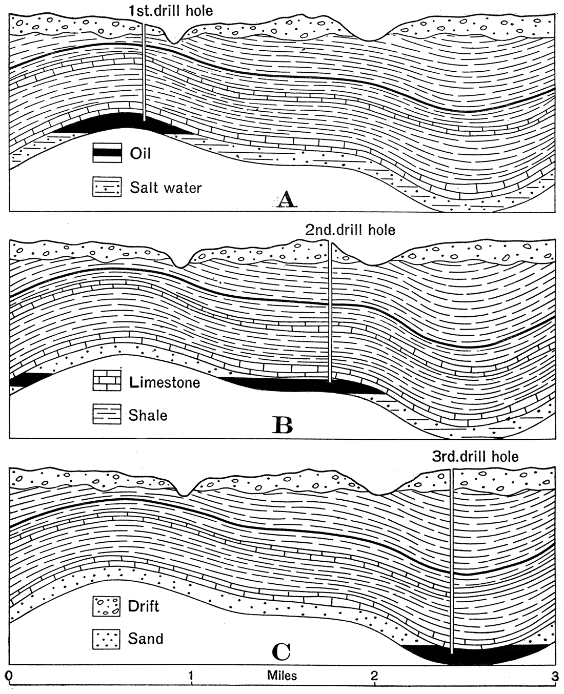
The agencies which have been discussed in describing the movements of oil and gas through the rocks may under proper conditions operate to form at least partial accumulations of these materials. Thus in very porous, dry rocks gravitation may cause a downward migration of oil into the lowest available spaces, such as the bottoms of synclines. as observed in parts of the West Virginia and Pennsylvania oil fields (Figs. 4C and 6.) In general, however, the conditions requisite for accumulation of oil by gravitation are absent, and as gravity is at best a rather ineffective cause of oil movement, concentration by it must be regarded as exceptional. Capillary attraction, especially the difference in capillarities of oil and water, is competent to produce an initial concentration of oil and gas in the coarsest and most porous available strata, but such accumulations are probably in few cases sufficiently large to be treated as commercial pools. Similarly, displacement and gas pressure may produce concentrations of oil and gas, but probably not in important amounts. Difference in specific gravities tends to concentrate the gas, oil and water at definite levels in the rocks (Fig. 4), the degree of the separation depending on the porosity of the rock, and to a certain extent in many cases on the motion of the materials through the strata. The separation and concentration due to specific gravities are especially important in producing commercial pools of oil and gas. the character of the accumulations depending, of course, on geologic structure and other conditions. It is especially important in the very broad, lens-shaped reservoirs which are the largest producers in the Midcontinent field. Even where the reservoir has not been tilted from the horizontal, the roof is sufficiently tilted in most cases to permit a separation according to specific gravities and hence an accumulation of gas and oil.
Figure 4—General diagram showing the relation of oil accumulation to geologic structure: A, in anticline; B, in structural terrace; C, in syncline. (Ill. Geol. Survey.)
Oil and Gas Reservoirs
In the first-discovered fields oil and gas were found in porous sandy strata which varied in texture from fine-grained sandstones to conglomerates. These rocks were termed sands, and the porous part of the sands containing oil or gas, pools. [The proper usage of the various terms applied to various portions of oil- or gas-containing rocks, such as sandbody, reservoir, pay, pool, and oil sand, have been summarized recently by Johnson and Huntley, Principles of oil and gas production, pp. 39-40, 57-59, 1916.] Discoveries in Ohio and Indiana have shown that oil and gas may occur in limestone, while in a few fields (Florence, Colo., and parts of California) the oil has accumulated in fissures in shale. In a few recorded instances oil has been found in igneous and crystalline rocks, though not in sufficient amounts to be important. The term "sands" as applied broadly to any oil- or gas-containing rock, is not, therefore, an accurate lithologic term. although most oil and gas accumulations are actually in sand or sandstone. The name reservoir is now applied to the sufficiently porous part of the sand or other rock which is capable of holding and yielding a commercial quantity of oil or gas if they are present. It includes the whole porous volume of the rock, whether it contains water, oil or gas, or if part of the space is dry.
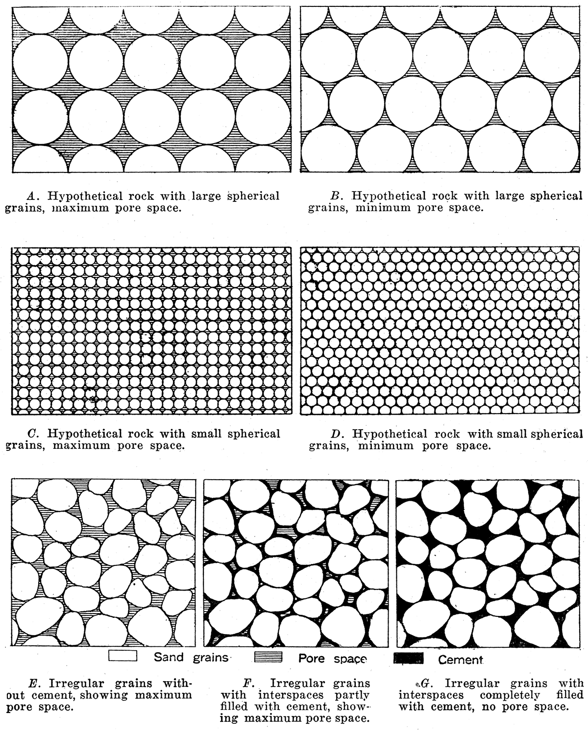
The fundamental requisite of an oil and gas reservoir is porosity. Shales have a relatively slight amount of pore space and the existing pores are very fine. Therefore, even though a shale is saturated with oil, a well drilled into it will hardly obtain a showing of oil, because the fineness of the openings in the rock hinders the escape of the oil. Limestones are in the majority of cases compact and rather fine grained, containing a relatively low amount of available pore space. The percentage of pore space in average sandstone is higher but is by no means so large as that of most sands and conglomerates, because the cementing material binding the grains of the sandstone together fills the pores to a greater or less degree. In average sandstone it varies from 5 to 15 percent, while in sands it may amount to 15 or 25 percent, and in conglomerates to as much as 30 percent. The porosity of the sands and sandstones varies with a number of factors, such as the size of the grains, the uniformity of their shape, and the amount of clayey matter or cement between the grains (see Plate III). Spherical grains of uniform size, without any cement, would have a maximum pore space; grains of irregular shape and size, with abundant cement, would have a minimum pore space. In case the spaces between the grains are completely filled with solid matter the rock may be absolutely compact and impervious (Plate III, G).
Plate 3—Pore space of rocks. The total amount of pore space in A. and C, or in B and D, is the same, but a fluid may be drained much more quickly and completely from the coarse-grained rock. A. Hypothetical rock with large spherical grains, maximum pore space. B. Hypothetical rock with large spherical grains, minimum pore space. C. Hypothetical rock with small spherical grains, maximum pore space. D. Hypothetical rock with small spherical grains, minimum pore space. E. Irregular grains without cement, showing maximum pore space. F. Irregular grains with interspaces partly filled with cement, showing maximum pore space. G. Irregular grains with interspaces completely filled with cement, no pore space.
In sandstone of this type there can naturally be no commercially important accumulation of oil. The dry, nonporous sandstone may occur as local "dry spots" in the midst of porous sand reservoirs containing abundant oil and gas, or they may be extensive enough to separate adjoining pools. Since the lack of porosity is a matter of the rock texture, such irregularities can not be predicted or defined except by drilling.
There is a not uncommon belief by many that oil is derived from underground lakes which are encountered by the drill. From the statements which have been made it is obvious that this is not a necessary assumption with regard to the oil reservoirs, as the small pore spaces between the grains of the rock offer quite sufficient room for the accumulation of the oil and gas. Thus in each 100 cubic feet of a sand containing 20 percent pore space 20 cubic feet of oil might occur. An acre of such a sand, ten feet thick, would contain, if saturated, 15,553 barrels of oil, and greater thicknesses correspondingly greater amounts. It should be noted, however, that the total oil actually contained in a reservoir is never entirely capable of recovery.
An all-important requirement for the accumulation of oil and gas is an impervious cover or retaining roof which will hold the oil and gas in the porous reservoir. Such an enclosing cover may consist of almost any very fine or compact rock, such as shale, closely cemented sandstone or dense limestone. If the fine pores of the cover rock are filled with water it is the more effective in retaining the contents of the reservoir below. In the absence of a suitable cover the oil and gas will escape from the reservoir, the lighter oil becoming volatilized and leaving behind a heavy residue. The abundant and heavy shales of the oil-bearing strata in Kansas have hindered the escape of the oil and gas, but at the outcrop of certain interbedded sands in Missouri (in the vicinity of Higginsville and elsewhere) heavy asphaltic deposits have been formed, due to the escape and evaporation of petroleum formerly present in the rocks. Impervious strata occur beneath as well as above most oil- and gas-containing beds.
The lateral extent of the reservoir rocks is a matter of importance. If the sand is lenticular in shape (Fig. 5) the capacity to hold oil and gas is gradually reduced in all directions until at the point where the sand disappears it is zero. If such a lenticular reservoir is enclosed between relatively impervious shale beds it may contain a large accumulation of oil and gas, even when inclined steeply, the shale at the end of the sand serving to retain the oil and gas. A very large number of the oil and gas reservoirs of the world are of this type. They are especially common in the Midcontinent field.
Structural Relations of Oil and Gas
The accumulation of oil and gas has a fundamental relation to the geologic structure of the rocks containing them. There is rarely, if ever, a sufficient quantity of oil and gas initially distributed throughout a reservoir to permit commercial production, and consequently there must be a concentration of these materials in the reservoir. This further concentration is chiefly due to the geologic structure. In perfectly horizontal strata there is no force compelling accumulation of the oil and gas at any particular place in the reservoir rock.
Where the rocks are tilted there is a tendency which is proportional to the amount of tilting and the degree of porosity of the rocks for the oil to move along the strata. If the reservoir is very dry and sufficiently porous the oil will move downward under force of gravity, but if the. rocks are saturated with water, the oil and gas will be floated upward along the stratum. In the former case, which is exceptional, the oil may become concentrated at the bottom of a syncline or where water or some. other obstacle is encountered (Figs. 4C and 6). Oil accumulations of this type occur in the folded rocks of Pennsylvania and West Virginia and in at least one field (Spring valley, Uinta county) in Wyoming. Downward movement of the oil, as previously stated, tends rather to dispersion than concentration. In the latter case the oil and gas are lifted as far as the water rises. If the water advances only a portion of the possible distance, the oil and gas may be partially concentrated and will not be under pressure (Fig. 6, bed b). If, however, the pressure of the water is strong they will be forced through the porous bed until they reach the earth's surface and. escape, or until some obstacle is encountered which hinders further movement, when they may be compressed to occupy a minimum of volume. The obstacles to unimpeded upward migration of the gas, oil and water are various. If the reservoir rock is lenticular in shape the terminal upper portion of the lens will retain the fluid contents of the rock by reason of the enclosing impervious beds, the gas accumulating at the top, the. oil next below, and the water occupying the lowermost portion of the reservoir (Fig. 5). In some cases the reservoir stratum is broken across by a clay-sealed fault (Fig. 7) or fine-grained igneous intrusion which obstructs the movement of the gas, oil and water through the rocks, and accumulation takes place in the same manner. Where an oil- and gas-containing bed outcrops at the surface the oil and gas may escape, but in some instances the outcropping reservoir is effectively sealed by the very viscous or solid paraffin or asphaltic residues which remain in the pores of the rock after the partial escape and evaporation of oil. Such a barrier may operate effectively to produce a concentration of the oil remaining in the reservoir.
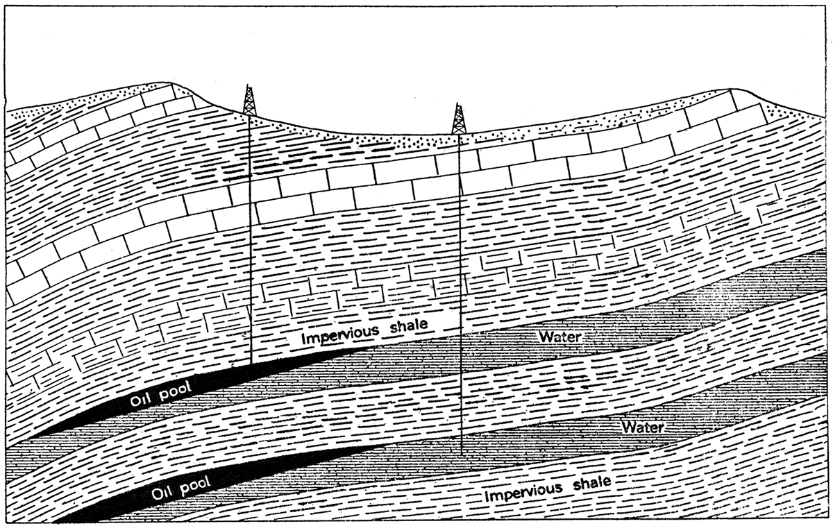
Figure 5—Diagram showing oil and gas in porous lenses. The gas, oil and water accumulate in the order of their respective specific gravities, being hindered from escaping by the pinching out of the reservoir between beds of essentially impervious shale. Notice that there is no indication in the geologic structure of the existence of such oil deposits. The inclination of the beds is considerably exaggerated,
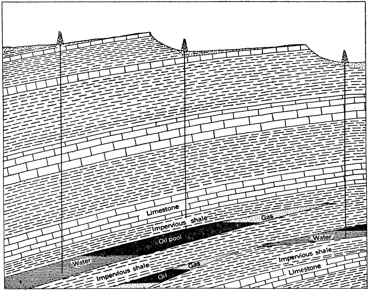
Figure 6—Diagram showing oil in a syncline. This diagrammatic, geologic cross-section shows the occurrence of oil in a synclinal fold in which one porous stratum (a) is entirely dry, and in which another (b) is partly filled with water. It will be noted that in the dry stratum the oil sinks to the bottom of the fold, but in a partly tilled bed it is floated on the water a certain distance up the sides of the fold. The vertical scale is greatly exaggerated.
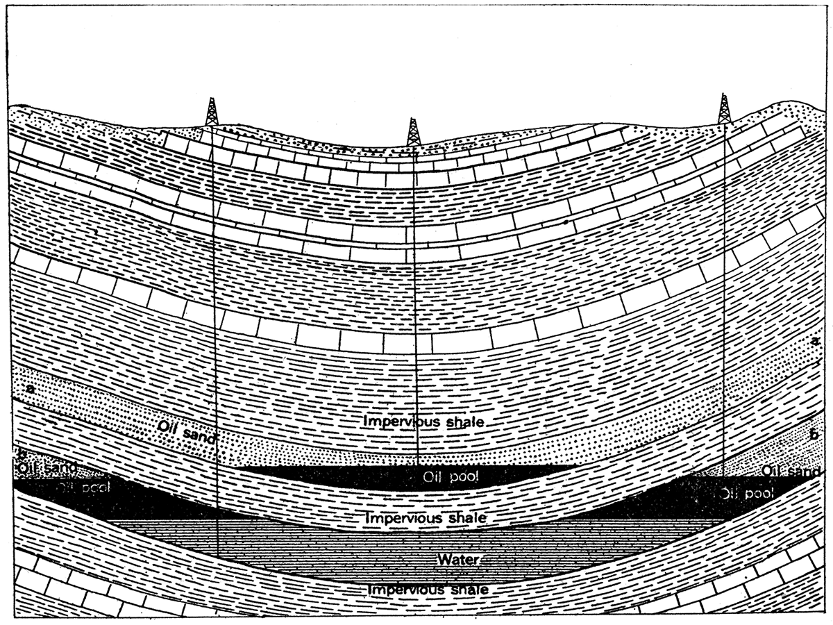
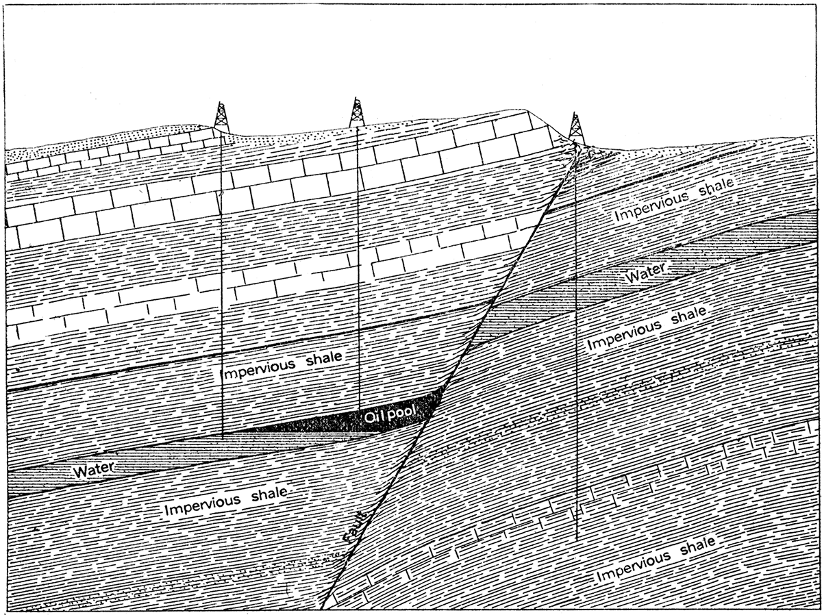
Figure 7—Diagram showing oil sealed in by a fault. The oil in the porous bed has accumulated above the water, but is hindered from escaping by the impervious shale and clayey matter which cut across the oil reservoir. Oil formerly in the stratum to the right of the fault has escaped. Slight oil seepage may occur where the fault appears at the surface, but a well drilled here has missed the oil pool.
By far the most important obstacle to continued movement of oil, gas and water along the reservoir, and hence a most significant cause of oil and gas accumulation, is a marked lowering of the angle of inclination or a reverse tilting of the upwardly inclined reservoir stratum, forming a monoclinal (Fig. 8) or an anticlinal fold (Figs. 4A, and 11) or dome.
Figure 8—Diagram showing oil in a structural terrace or monocline. The oil has been moved up the steeper parts of the porous beds, but where the strata are flattened there is not sufficient pressure to produce movement. Accordingly the oil has accumulated at this place, The inclination of the beds is greatly exaggerated.
Under these conditions the oil and gas are lifted into the uppermost part of the structure, where they are prevented from further movement and escape by the impervious cap rock which overlies the reservoir bed. The gas, by reason of its lightness, will accumulate at the top of the structure immediately beneath the cap rock; the oil, having a specific gravity lower than the water, will be separated in a zone or layer between the gas and water, and the water will occupy the lowest parts of the reservoir. In proportion to the sharpness of the anticline and the steepness of the inclination of the strata on either side, the oil and gas will be concentrated into narrow limits and the pressure will tend to increase. In some districts in California and parts of the Rock Mountain fields the oil-containing strata stand vertically, or are even overturned, and the amount of the arching or folding may be from 500 to 5,000 feet. In many cases, on the other hand, the anticline is so very broad and gentle, or the structural terrace (monocline) so ill defined, that the accumulation is not very effective. In Oklahoma and Kansas the strata have everywhere a very slight inclination, and the amount of folding or uplift is rarely more than 100 or 200 feet. For example, the vertical distance from the top of the anticline to the bottom of the adjoining syncline at Cushing, the most productive pool in the Midcontinent field and one of the most remarkable in the world, is but 160 feet. Such low deformations occur in most cases in a distance of one-half mile to a mile.
It should be observed that not all folds, even well-defined anticlines in oil regions, are productive of oil or gas. In some cases a structure is thought to be "dry" when the only difficulty is in the insufficient depth of drilling. Scores of instances might be cited from various localities in Kansas where after many unsuccessful tests oil has been discovered in quantity by merely drilling to greater depths. Some folds contain very good oil and gas deposits in certain portions of the structure, but are barren in others; This is due to variation in the porosity of the reservoir, the nonproductive part being so low in percentage of pore space as to contain little or no oil or gas, the productive part showing all the characteristics of the normal porous reservoirs. Such a lack of uniformity in the reservoir is rather the rule than the exception, and the existence Of a single dry well does not by any means condemn a structure. In other instances, however, the structure is absolutely barren, the conditions having been unfavorable in various ways for the accumulation of the oil and gas. Some of these unfavorable conditions are as follows: (a) Local absence of matter (probably organic) from which oil and gas are derived, or lack proper initial conditions for preservation and distillation; (b) lack of porous rocks suitable for reservoirs; (c) lack of water to saturate the reservoir rock and force oil and gas to the top of the structure, in which case the oil, if present, will lie on the sides of the folds or in the bottom of the synclines; (d) presence of intrusives or old land mass (granite of central Kansas) below the central portion of the fold.
In summary, the essential general facts with reference to commercially important pools of oil and gas may be stated as follows: (a) All so far discovered occur in sedimentary or water-laid rocks, such as sands, sandstones, conglomerates, limestones and shales; (b). the containing reservoir is a porous rock, the amount of porosity and size of the pores directly controlling the possible accumulation and production of oil and gas; (c) the reservoir is capped or covered by practically impervious beds of shale, limestone or sandstone, similar impervious beds in most cases also underlying the reservoir; (d) water is present in almost all cases in the oil and gas reservoir, and because of its greater specific gravity, tends to occupy the lowermost portion of the reservoir; (e) commercial oil and gas deposits are closely related to the structural character of the associated rock strata, occurring for the most part in the higher parts of folds, such as anticlines, domes and monoclines.
Exploration for Oil and Gas
The evidences of the presence of petroleum or natural gas which are commonly noted by geologists, and used by them in the exploration of commercial pools and their development, are not such as can be seen and comprehended by the average layman. These may for convenience be divided into (1) direct surface indications, and (2) indirect evidences. The former, which offer the more definite evidence of the existence of oil in the rocks, either in the particular locality of their occurrence or at a distance, include (a) oil seepages, or springs, (b) natural-gas springs, and (c) outcrops of sand impregnated with petroleum. The indirect are the structural features of the region which are so important in the accumulation of oil and gas.
(1) Direct Indications.
(a) Oil seepages may exist where the outcrop of an oil sand reaches the surface, or where there is a crevice or fault through which the oil may rise to the surface. Seepages are most common in the lowlands or along small streams, sometimes appearing only as a faint scums on the water. [Note: Distinction must be made carefully between true oil scums and those of other substances on water. For instance, iron scum has been very commonly mistaken for petroleum, and some operators have invested thousands of dollars on such slight evidence. As a rule, where a film of petroleum is present it can be distinguished from that of iron by its odor. A small stick thrust into an iron scum will break it up into separate patches, while an oil scum is so thin and cohesive that it will retain its unbroken appearance and its iridescent color.] In certain oil regions the occurrence of these scums on the surface of rivers, lakes and ponds is rather common, but in the Midcontinent field oil seepages are rather rare. The reason for this is that the beds in this region are so slightly tilted that for the greater part they remain unbroken, and there have been no means by which the oil could reach the surface except perhaps in the minutest quantity. Where the oil formations reach the surface in the Midcontinent field the oil has doubtless already leaked away, owing to the fact that the productive strata are of considerable geologic age and there has been ample opportunity during long periods of erosion for the oil and gas to escape.
(b) In some oil and gas fields bubbles of gas rise in minute quantities through the water to the surface of streams, and at a few localities there are great gas springs. One such spring in the Baku district of Russia has been actually burning for thousands of years (Clapp, Frederick G., The geology of petroleum: Am. Petroleum Industry, by Bacon and Hamor, vol. 1, p. 36, 1916).
(c) Outcrops of sand impregnated with bitumen, the so-called tar or asphalt sands, are not common, but exist in several parts of the world. One of the best-known occurrences in North America is that along the Athabasca and other rivers of northern Alberta, in Canada. Recently an asphalt-impregnated sandstone has been reported from the vicinity of Higginsville, in Missouri.
These surface indications have certain association with petroleum or natural gas, but commercially important pools of these materials in many instances lie at a distance from the point where the evidence appears at the surface. For example, where oil, gas or asphalt seepages occur at the outcrop of a gently inclined formation the important commercial deposits of oil may exist at a distance of several miles from the exposed outcrop. For this reason it is generally inadvisable to drill on or near seepages unless there is evidence that the main deposit of petroleum occurs directly below. In many cases it is possible for a geologist to locate the field from which the oil or gas has escaped.
(2) Indirect Indications.
From what has been said of the conditions governing the accumulation of oil and gas in the porous rock strata it is evident that another class of surface indications may be used in exploration for these materials. This is the presence of folding in the rock strata, which if pronounced may be observed readily with the eye. If the folding is very slight it may be detected only with the aid of instruments by which the elevation of the outcrops of given strata may be noted and the direction and amount of their dips registered. By studying and mapping these indications of the rock structure carefully a geologist is able to define fairly closely the general structure of the underground strata (Figs. 10 and 11). Hence, if oil and gas are present in the strata au all, the position of their accumulation with reference to the observed geologic structure may be predicted, and the area of more favorable production definitely and scientifically indicated. In the case of a well-defined anticline or dome (Figs. 4A, and 11) the central portion of the dome would be most likely to contain gas and oil. Wells drilled on the sides of the structure would probably strike oil or water.
Figure 9—Topographic map of a small area, showing the position and elevation of outcrops of a prominent limestone bed. The lines, called contours, drawn around the hills are of constant elevation above mean sea level and are drawn at regular vertical intervals. Thus they show the actual elevation of the country, the shape of the hills and valleys and the character of the slopes. The limestone formation traced by geologist appears at different elevations over the area, indicating definitely that the strata are not horizontal. A-B shows the line of vertical cross-section, Figure 11.
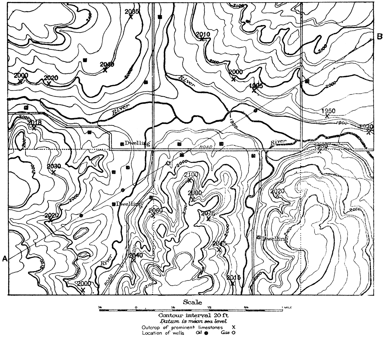
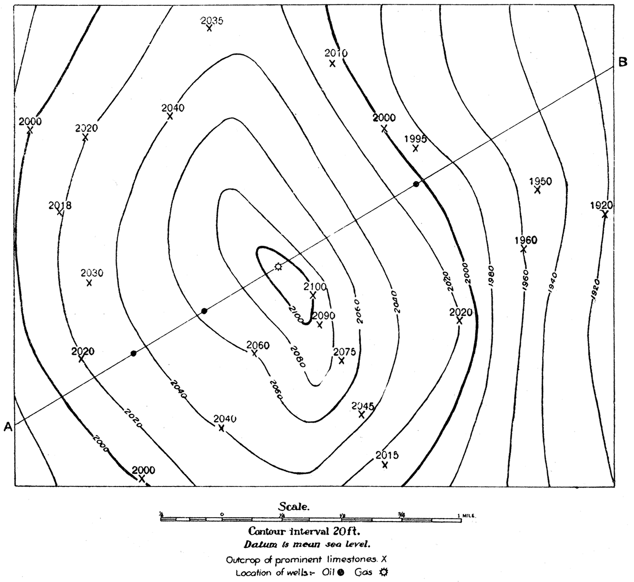
Figure 10—Structure contour map of area shown in Figure 9, indicating the elevation and structure of prominent limestone bed. It should. be imagined that the portion of the limestone bed which has been eroded away (see Fig. 12) is restored and that all of the beds overlying the limestone are removed. The surface of the limestone would then appear as a low dome sloping away gently on all sides. If the area were flooded with water standing at 1,920 feet above sea level the contour at this elevation would represent the shore line, and if the water were raised by twenty-foot intervals the successive shore lines would be represented in turn by the higher contours. Thus if the water level were lifted to 2,100 feet only a small island in the center of the area would indicate the surface of the limestone bed.
It is evident that the structure of the rocks has little or nothing to do, necessarily, with the character of the surface topography. Thus, the crest of a rock anticline may directly underlie a valley at the surface. (Fig. 11 and Plate IV).
Figure 11—Vertical cross-section along line A-B across area shown in Figure 9. The vertical scale is exaggerated about 4 1/2 times.
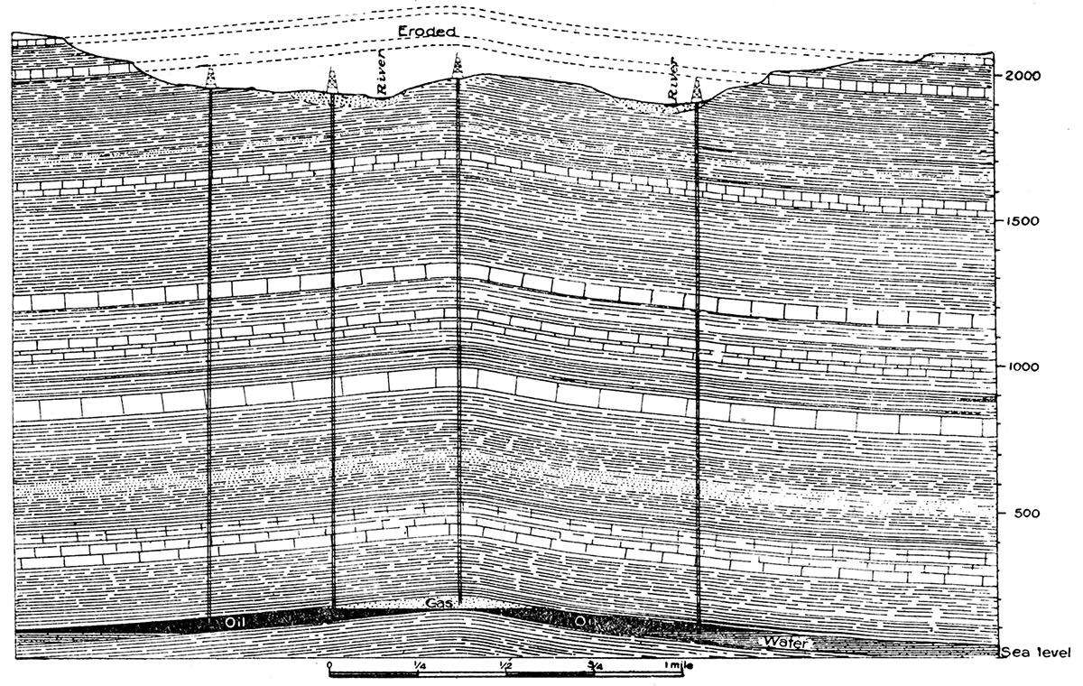
Plate 4—Stereogram showing surface topography and underground structure of a typical oil and gas pool. The upper part shows the area mapped in Figure 9, and below it a slightly folded gas- and oil-bearing sandstone layer, the structure of which was indicated by observations of the outcrops of a prominent limestone bed (Figs. 9 and 10). The line of cross-section A-B, and wells (Fig, 11) are indicated . Notice that the configuration of the land at the surface docs not necessarily have any relation to the underground structure.
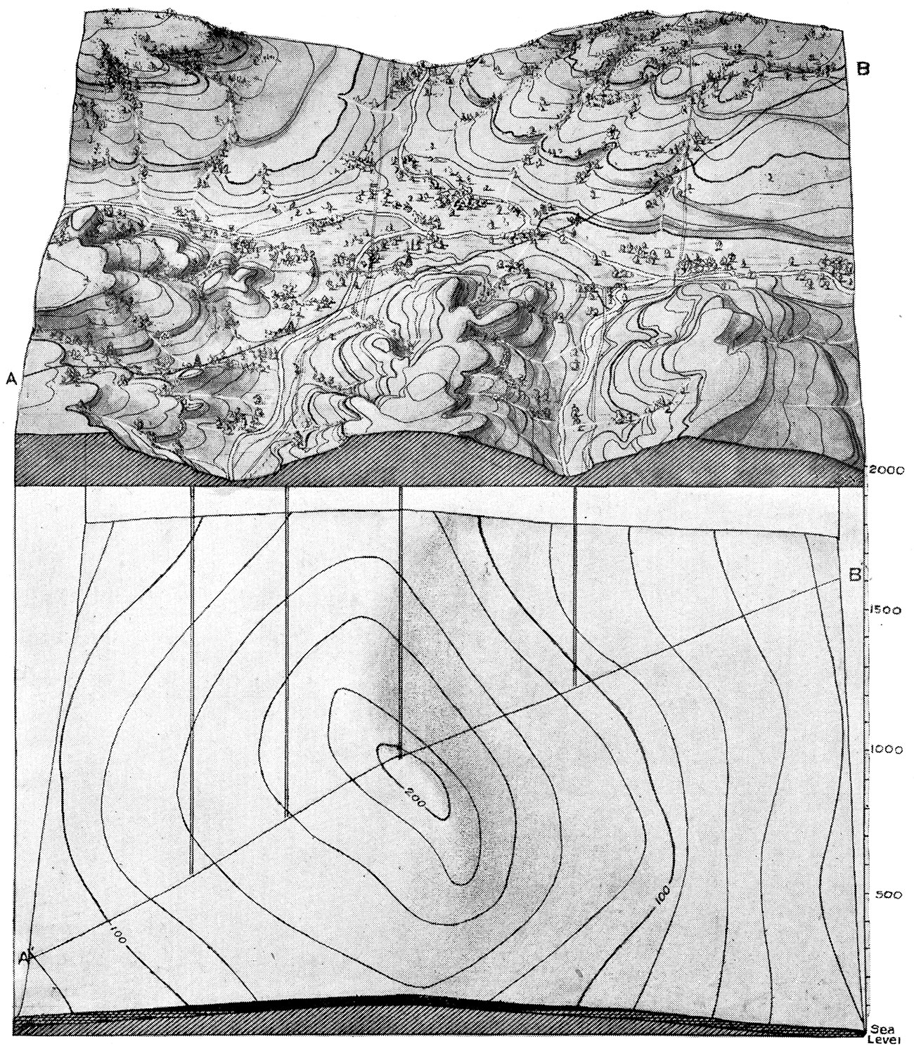
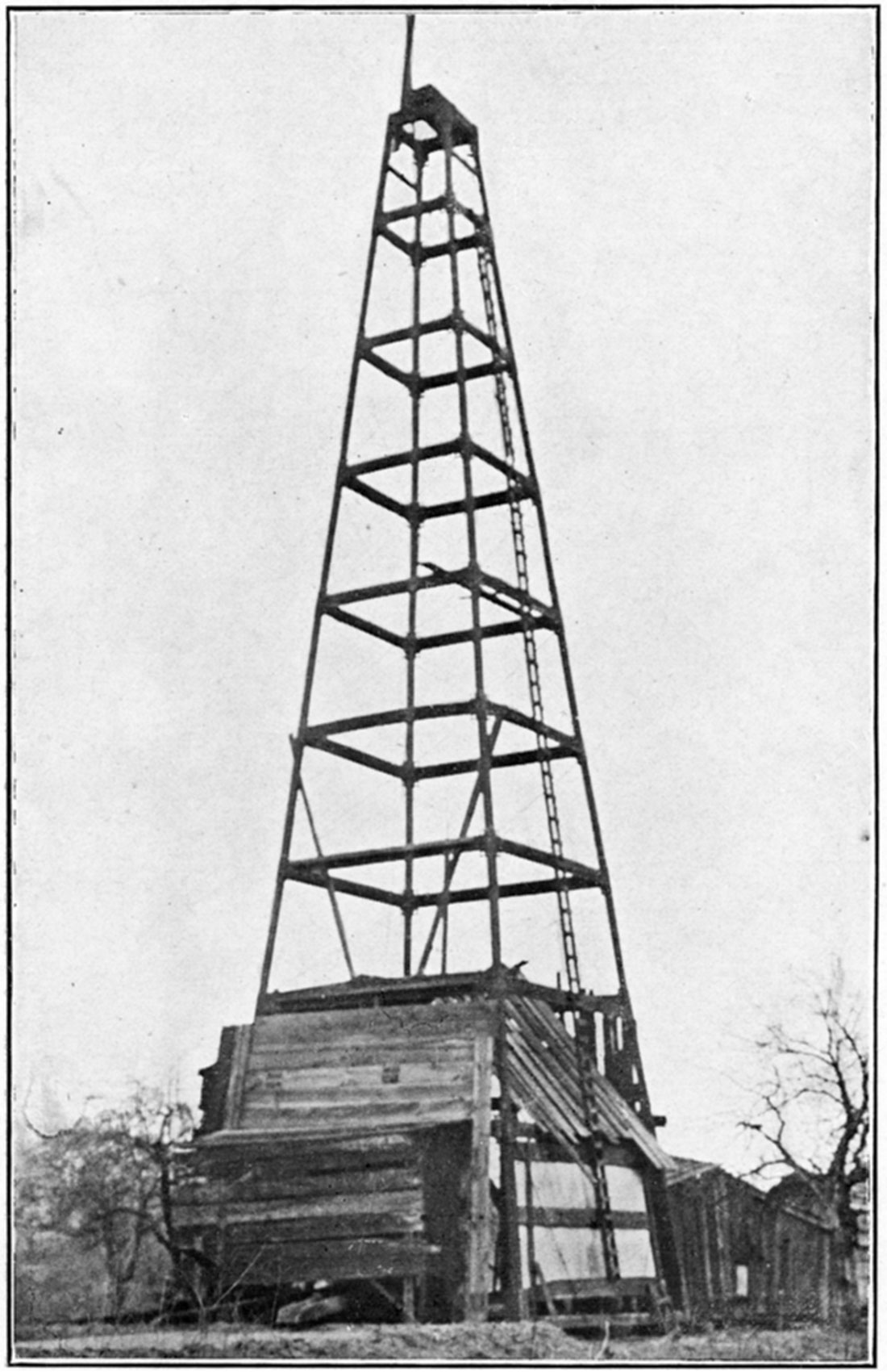
Plate 5—The standard derrick. (Ill. Geol. Survey.)
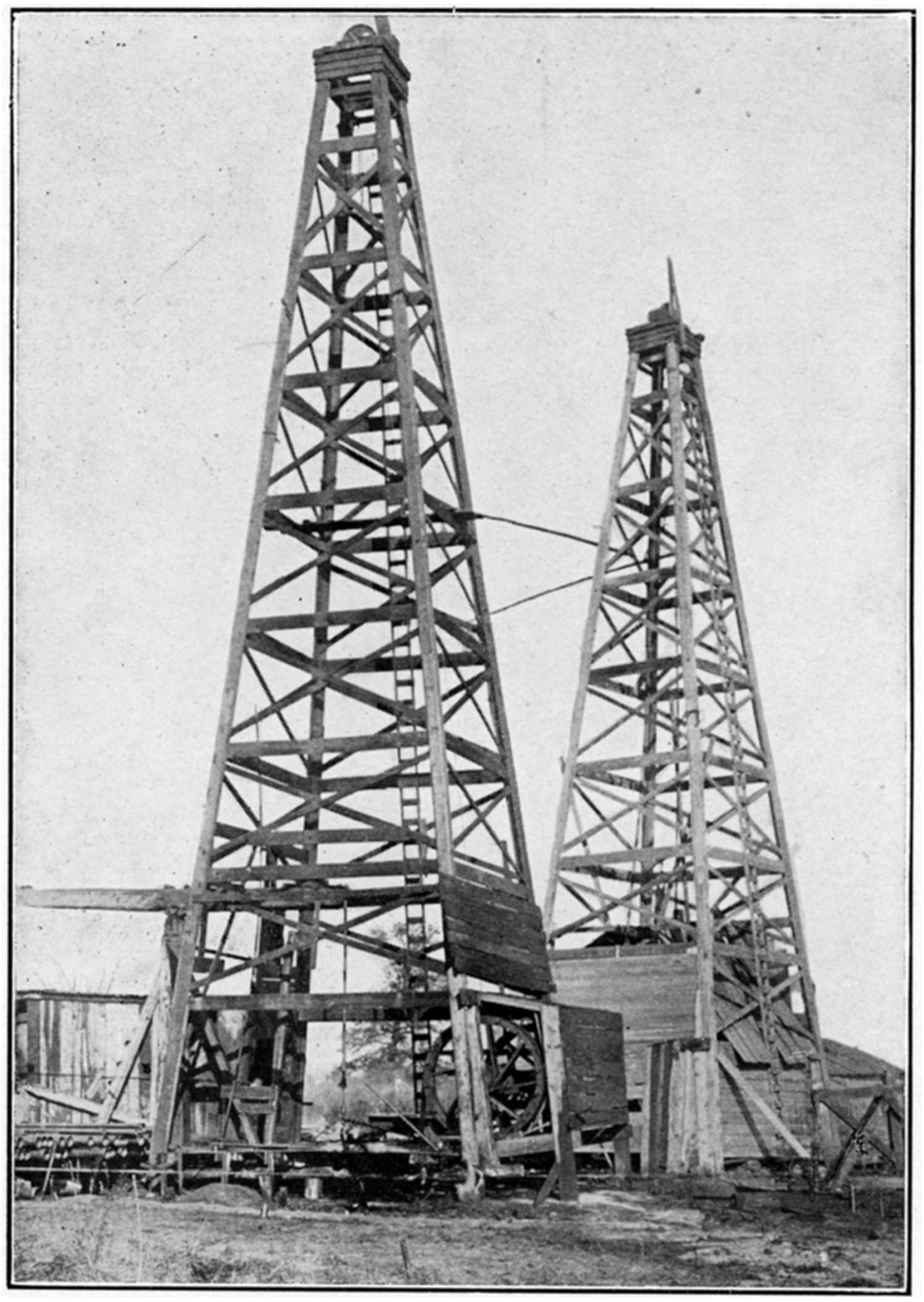
Plate 6—The steel derrick. (Ill. Geol. Survey.)
In most oil regions, and especially in Kansas, there are numerous places where the solid rocks can be found in outcrops from point to point over the land. In most cases the ravines and creeks cut into the rocks in their natural bedding, and exposures are also to be found along roadways or in railroad cuts. These are very important in working up data for the geologic structure map. Indeed, without rock outcrops or other indication of the character and attitude of the strata, the geologist can do little.
In practice a single prominent bed, such as a limestone horizon or a coal bed, is selected, and the measurements of geologic structure are either made directly on the chosen stratum or are referred to it. Since the sedimentary rocks of the earth are bedded over one another like the leaves of a book, the folding of the top layers indicates more or less accurately the folds of the lower layers. Consequently the structure of the key bed at the surface indicates the structure of the oil and gas strata perhaps some thousands of feet below. This relation between the rocks at the surface and those deep below must be understood clearly to appreciate the work of the geologist. It should be borne in mind that vast quantities of rock have been removed from the surface of the earth by erosion. Ledges on one side of a valley match those on the opposite side, and the beds of one hill those in another. The mind must restore what erosion has taken away in order to form a picture of the original continuous extent of the key layer.
A very common mistake among prospectors for oil and gas, especially in the early development of petroleum in the United States, has been the belief that oil and gas pools run in uniform directions through the rocks. Accordingly, in certain fields thousands of wells have been drilled along definite lines and at given angles from existing pools, which were supposed to represent the position of new deposits. The only lines which are of value in developing known oil pools or in the location of new ones are the structure contour lines of the geologist (see Figure 10).
Prev Page--Petroleum and Natural Gas || Next Page--Production
Kansas Geological Survey, Geology
Placed on web Aug. 10, 2018; originally published 1917.
Comments to webadmin@kgs.ku.edu
The URL for this page is http://www.kgs.ku.edu/Publications/Bulletins/3/05_geol.html