![]()
Prev Page--Investigations, Small Valleys || Next Page--Summary
Holocene landscape evolution in the Pawnee River basin
The purposes of this section are to summarize the record of Holocene erosion, alluviation, and landscape stability in the Pawnee River basin and to provide interpretations of that record. First, geomorphic data and stratigraphic records from large and small valleys in the Pawnee River basin are described and compared. Second, a Holocene alluvial chronology of the Pawnee River system is constructed from radiocarbon assays. Third, the Holocene history of the Pawnee River basin is compared with alluvial chronologies of other streams in the Central Plains. Finally, causal factors of Holocene erosion, alluviation, and landscape stability in the Pawnee River basin are considered.
Terraces, valley fills, and soils in the Pawnee River basin
As many as three terraces are present in the valley bottom of the Pawnee River (fig. 77). All these terraces are essentially the original depositional surfaces of valley fills (filltop terraces), although the surface of T-3 fill has been somewhat modified by erosion and loess deposition. T- 3, which is the highest terrace, has a broad, gently sloping surface, 7-8 m (23-26 ft) above the modern floodplain. This terrace is paired and nearly continuous along the entire course of the Pawnee River. Limited subsurface investigations revealed a 1-2-m-thick (3-7-ft-thick) deposit of Peoria loess on the T-3 surface. The loess overlies a truncated Bt horizon developed in alluvium. This paleo-Bt horizon is reddish and exhibits strong structural development. Valley fill beneath the truncated paleosol consists of 2-3 m (7-10 ft) of loamy alluvium grading downward into sandy and gravelly deposits.
Figure 77--Generalized cross sections of (A) small valleys, (B) lower reaches of fourth-order stream valleys, (C) and large valleys.
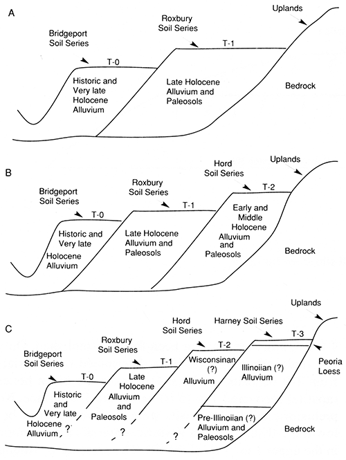
An intermediate terrace (T-2) occupies a portion of the valley floor in the middle reach of the Pawnee River, but it was not observed in the upper and lower reaches. This terrace is paired in some areas and unpaired in others. The T-2 terrace is a broad, flat surface, 5-6 m (16-20 ft) above the modern floodplain. One cutbank exposure of T-2 fill was briefly examined at locality PR-8, where a 6-m-thick (20-ft-thick) unit of brown and pale-brown massive silty sediment extended from the T-2 surface to the base of the exposure. No buried paleosols were detected in the exposure, and the absolute age of the fill is unknown. However, based on radiocarbon ages determined on humates from deeply buried paleosols in the adjacent T-1 fill, the T-2 fill is older than 10,300 yr B.P.
The lowest terrace (T-1) has a broad, flat surface that dominates the valley floor along nearly all of the Pawnee River. This terrace usually is on both sides of the river and is separated from the modern floodplain by a 3-5-m-high (10-16-ft-high) scarp. Valley fill underlying the T-1 terrace is up to 50 m (160 ft) thick in the middle and lower reaches of the Pawnee River. Deposits composing the lower 20-30 m (65-100 ft) of the fill largely consist of bedded sands and gravels. These coarse-grained lateral-accretion deposits are mantled by thick, fine-grained vertical-accretion deposits.
Buried paleosols are common in the upper 7-10 m (23-33 ft) of the T-1 fill (fig. 78). Most of the buried late Holocene paleosols have A-C or thin A-Bw profiles. A few late Holocene soils with A-Bk profiles were observed in the lower Pawnee River valley; however, the Bk horizons have weak carbonate morphology and show little or no evidence of clay illuviation. In contrast, early and middle Holocene soils usually are strongly developed and have thick clay-rich Bk, Bt, and/or Btk horizons. Also, some of the early and middle Holocene soils were truncated by erosion before burial, and in some cases only their B horizons remain (fig. 78).
Figure 78--Stratigraphy in large and small valleys of the Pawnee River basin.
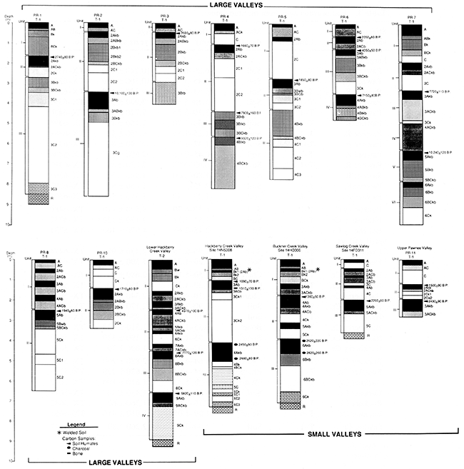
The stratigraphic record preserved in T-1 fill indicates that episodes of stream erosion during the early and middle Holocene were separated by periods of alluviation. However, since no 14C datable materials, such as charcoal or wood, were found in T-1 fill, absolute ages of alluvial deposits could not be determined. Instead, relative ages of deposits were inferred from the paleosol record where more than one buried soil was radiocarbon-dated within a section.
Deposits of Historic alluvium, up to 2 m (7 ft) thick, cover much of the T-1 terrace in the middle and lower reaches of the Pawnee River valley. These deposits consist of stratified clays, silts, and very fine sands, and they often contain Historic artifacts. Surface soils developed at the top of Historic fill are Haplustolls with thin A-C profiles. The mantle of Historic alluvium generally becomes thinner with increasing distance from the modern channel of the Pawnee River, and it is usually absent near margins of the valley floor. This factor accounts for soil variability observed along some cross-valley transects. For example, at locality PR-3 a young surface soil with a thin A-C profile is developed in deposits of Historic alluvium on the T-1 terrace. The Historic alluvium mantles a late Holocene soil with an A-Bk profile developed into T-1 fill. This buried late Holocene soil is the surface soil where the mantle of Historic alluvium is absent.
The modern floodplain (T-0) of the Pawnee River is 20-150 m (66-490 ft) wide and 2-3 m (7-10 ft) above the bottom of the river channel. The T-0 fill is composed largely of sandy and gravelly lateral-accretion deposits capped by silty and clayey overbank deposits. Archeological and soil evidence suggests that T-0 surfaces are Late Prehistoric to Historic in age. At site 14HO5 at locality PR-9, Middle Ceramic potsherds were found in a cultural horizon 1 m (3 ft) below the T-0 surface. Hence alluvial deposits above the cultural horizon are no greater than 1,000 years old and may be less than 500 years old. Soils developed at the top of the T-0 fill are Haplustolls with thin A-C profiles; they have not developed long enough to have B horizons. The morphology of these soils suggests that the T-0 surfaces are young.
All the tributaries of the Pawnee River are fourth-order or smaller streams. The valley floors of second- and third-order streams are composed of two landforms: a narrow floodplain (T-0) and a low, broad terrace (T-1) (see fig. 77). The T-0/T-1 sequence also characterizes most reaches of fourth-order streams, but a second terrace (T- 2) is present near their confluences with the Pawnee River. As was the case in large valleys, all terraces in small valleys are original depositional surfaces of alluvial fills (filltop terraces).
The T-2 terrace is unpaired, and its surface is 6-7 m (20-23 ft) above the modern floodplain. A detailed subsurface investigation of the T-2 fill was conducted at locality HC-2 along lower Hackberry Creek. The T-2 fill at this locality is about 8 m (26 ft) thick and is composed almost entirely of fine-grained overbank alluvium. Eight buried paleosols were identified below the T-2 surface (see fig. 78). Although most of these paleosols are characterized by thin A-C profiles, two have an over-thickened A horizon above a C horizon and one has a thick Bk horizon. Based on radiocarbon ages determined on humates from buried paleosols, the bulk of the alluvium beneath the T-2 terrace accumulated during the early and middle Holocene. The modern surface soil at the top of the T-2 fill is a Haplustoll with A-Bw-Bk horizonation.
The T-1 terrace dominates valley floors of small streams in the Pawnee River basin. T-1 is usually a paired terrace, although it is unpaired in portions of some valleys as a result of lateral stream erosion. The T-1 surface is separated from that of the modern floodplain by a 3-4-m-high (10-13-ft-high) scarp.
Deposits underlying the T-1 terrace were examined at many cutbank exposures, and detailed descriptions of soil stratigraphy were made at localities HC-1, BC-1, SC-I, and PR-11. The T-1 fill generally is 7-8 m (23-26 ft) thick and is composed of thick units of fine-grained overbank alluvium above thin basal deposits of stratified sand and gravel. Radiocarbon assays indicate that the bulk of the alluvium composing T-1 fill accumulated between ca. 2,800 and 1,000 yr B.P.
As many as five buried paleosols were identified in T-1 fill of small valleys (see fig. 78). Most of these paleosols are thin, weakly developed A horizons. However, two paleosols are relatively well developed and can be traced laterally throughout the low-order drainages. These soils were first recognized at site 14HO306 at locality BC-1. The oldest of the two buried soils, informally named the Hackberry Creek paleosol, has a 50-100-cm-thick (1.6-3.3-ft-thick) cumulic A horizon above a thin Bk horizon. This paleosol usually is developed in loamy alluvium near the base of the T-1 fill. At some localities, such as site 14NS308 (locality HC-1), a deep channel is cut into the Hackberry Creek paleosol and underlying fill. Radiocarbon assays suggest that formation of the Hackberry Creek paleosol began ca. 2,800 yr B.P. and continued until at least 2,000 yr B.P.
A younger buried soil in T-1 fill also has a thick, dark A horizon above a weakly developed Bk horizon. This buried soil, informally named the Buckner Creek paleosol, is developed in silty alluvium near the top of the T-1 fill. Archeological evidence and radiocarbon ages suggest that the Buckner Creek paleosol developed from about 1,350 to at least 1,000 yr B.P.
The Buckner Creek paleosol is mantled by 1-2 m (3-7 ft) of silty alluvium composing the upper portion of the T-1 fill. Surface soils developed at the top of the T-1 fill are Haplustolls with thin A-Bk profiles.
Modern floodplains in small valleys generally are 30-50 m (100-160 ft) wide, although floodplain surfaces are as wide as 100 m (330 ft) in lower reaches of major tributaries. Some streams downcut slightly [1-2 m (3-7 ft)] as they migrated across their valley floors. Consequently, floodplains may consist of several individual levels (T-0 complex) separated by short scarps. These individual levels cannot be traced up or down the valleys with any certainty.
Floodplain (T-0) deposits are inset against T-1 fill or bedrock walls in small valleys. The floodplain fill generally is less than 4 m (13 ft) thick and is composed of 1-2 m (3-7 ft) of fine-grained alluvium above alternating beds of sandy loam, sand, and gravel. Deposits underlying the T-0 surface are distinct from those beneath the T-1 surface in that the former are coarser, much more stratified, and rarely contain buried paleosols. The absolute age of T-0 fill, however, has not been firmly established. Only one radiocarbon age has been determined on materials from T-0 deposits: 1,010 ± 410 yr B.P. on bison bones (apatite) recovered 1 111 (3 ft) below the T-0 surface. No prehistoric cultural deposits were discovered on or below the T-0 surface, and Historic materials are common in the upper 1 m (3 ft) of the fill. The presence of Haplustolls with thin A-C profiles developed at the top of the T-0 fill suggests that the floodplain surfaces are young.
A comparison of soil-stratigraphic records from large and small valleys in the Pawnee River basin (see fig. 78) reveals a pattern. Specifically, late Holocene alluvial deposits and buried paleosols are present in both large and small valleys. However, middle and early Holocene deposits and buried paleosols are documented only in the main valley of the Pawnee River and in the lower reaches of major tributaries near their confluence with the Pawnee River.
The morphology of surface soils in valley bottoms of the Pawnee River basin is fairly consistent. With the exception of soils developed in the Peoria loess on the T-3 terrace, all surface soils are weakly developed Haplustolls characterized by A-C, A-Bw, or A-Bk horizonation. The presence of weakly developed soils suggests that the surfaces of most landforms in valley bottoms are relatively young. Radiocarbon ages determined on charcoal, bones, and humates from buried paleosols in large and small valleys indicate that the overlying deposits and hence the modern surface soils often are less than 2,000 years old.
Holocene valley history
Radiocarbon ages combined with age estimates based on temporally diagnostic archeological materials were used to outline the chronology of Holocene landscape evolution in the Pawnee River basin. The ages on which this chronology is based roughly span the Holocene (table 4).
Table 4--Radiocarbon ages from the study area
| Landform | Stream valley |
Material dated |
Depth (m) |
Age (years B.P.) |
Lab no. |
|---|---|---|---|---|---|
| Large valleys | |||||
| Pawnee R. | T-1 | Soil | 6.20-6.40 | 10,240 ± 120 | TX-6391 |
| Pawnee R. | T-1 | Soil | 3.45-3.70 | 10,100 ± 130 | TX-6374 |
| Pawnee R. | T-1 | Soil | 5.63-5.83 | 9,320 ± 120 | TX-6396 |
| Pawnee R. | T-1 | Soil | 5.28-5.48 | 7,900 ± 160 | TX-6392 |
| Pawnee R. | T-1 | Soil | 3.30-3.35 | 7,720 ± 110 | TX-6476 |
| Pawnee R. | T-1 | Soil | 3.50-3.70 | 7,150 ± 110 | TX-6398 |
| Pawnee R. | T-1 | Soil | 1.25-1.55 | 4,350 ± 50 | TX-6389 |
| Pawnee R. | T-1 | Soil | 1.42-1.62 | 2,740 ± 80 | TX-6375 |
| Pawnee R. | T-1 | Soil | 0.45-0.65 | 2,600 ± 80 | TX-6394 |
| Pawnee R. | T-1 | Soil | 0.60-0.95 | 2,050 ± 80 | TX-6390 |
| Pawnee R. | T-1 | Soil | 1.80-2.00 | 1,940 ± 60 | TX-6393 |
| Pawnee R. | T-1 | Soil | 2.75-2.95 | 1,850 ± 80 | TX-6397 |
| Pawnee R. | T-1 | Soil | 1.20-1.40 | 1,710 ± 80 | TX-6395 |
| Hackberry Cr. | T-2 | Soil | 6.50-6.70 | 9,820 ± 110 | TX-6480 |
| Hackberry Cr. | T-2 | Soil | 4.51-4.71 | 7,170 ± 120 | TX-4732 |
| Hackberry Cr. | T-2 | Soil | 2.45-2.65 | 4,970 ± 100 | TX-5731 |
| Small valleys | |||||
| Pawnee Cr. | T-1 | Soil | 1.95-2.15 | 2,430 ± 90 | TX-6474 |
| Pawnee Cr. | T-1 | Soil | 1.20-1.35 | 1,500 ± 80 | TX-6473 |
| Hackberry Cr. | T-1 | Charcoal | 5.50-5.15 | 2,680 ± 80 | TX-5640 |
| Hackberry Cr. | T-1 | Charcoal | 4.20-4.30 | 2,450 ± 90 | TX-5641 |
| Hackberry Cr. | T-1 | Charcoal | 4.10-4.15 | 2,340 ± 400 | TX-5639 |
| Hackberry Cr. | T-1 | Soil | 2.90-3.30 | 2,170 ± 50 | TX-5645 |
| Hackberry Cr. | T-1 | Soil | 2.10-2.50 | 1,950 ± 50 | TX-5645 |
| Hackberry Cr. | T-1 | Bonea | 1.55-1.60 | 1,310 ± 130 | TX-5643 |
| Hackberry Cr. | T-1 | Boneb | 1.55-1.60 | 1,190 ± 370 | TX-5643 |
| Hackberry Cr. | T-1 | Soil | 1.07-1.37 | 1,090 ± 70 | TX-5646 |
| Buckner Cr. | T-1 | Charcoal | 4.64-4.69 | 2,820 ± 260 | TX-5730 |
| Buckner Cr. | T-1 | Charcoal | 3.94-4.04 | 2,620 ± 220 | TX-5729 |
| Buckner Cr. | T-1 | Charcoal | 5.28-5.33 | 1,610 ± 100 | TX-5642 |
| Buckner Cr. | T-1 | Soil | 4.98-5.28 | 1,430 ± 50 | TX-5644 |
| Buckner Cr. | T-1 | Soil | 1.76-2.00 | 1,360 ± 60 | TX-5642 |
| Buckner Cr. | T-0 | Boneb | 1.00-1.05 | 1,010 ± 410 | TX-5651 |
| Saw log Cr. | T-1 | Soil | 2.00-2.30 | 2,260 ± 80 | TX-5647 |
| a. Apatite. b. Collagen. |
|||||
During the early Holocene (ca. 10,500-7,000 yr B.P.), alluviation in large valleys of the Pawnee River basin was punctuated by floodplain stability, soil formation, and erosion. Buried paleosols dating to this period are documented in T-1 fill of the Pawnee River and in T-2 fill of lower Hackberry Creek near its confluence with the Pawnee. Many of these paleosols are deeply truncated, indicating that periods of soil development were followed by episodes of stream erosion.
During the early and middle Holocene, between about 10,000 and 4,000 yr B.P., second- and third-order streams together with the upper and middle reaches of fourth-order streams were characterized by net transport of alluvium, with little or no long-term storage. It is likely that small streams were actively downcutting and lengthening during this period. Sediment transported out of these drainage elements accumulated as valley fill in the middle reach of the Pawnee River and in lower reaches of its major tributaries during the middle Holocene. This fill is stored beneath T-1 terraces of the Pawnee River and beneath T-2 terraces of fourth-order streams near their confluence with the Pawnee. Although middle Holocene deposits may be preserved in much of the valley fill stored beneath T-1 terraces of the lower and upper Pawnee River, their presence has not yet been documented.
Sedimentation on middle Holocene floodplains in lower reaches of major tributaries to the Pawnee River was episodic, with intervening periods of stability and soil formation. The nature of floodplain development indicates that transport of sediment out of the small basins draining to these lower reaches occurred with flood events during the middle Holocene.
A major shift in the locus of sediment storage took place during the late Holocene in the Pawnee River basin. Following the middle Holocene episode of downcutting and lateral erosion, second-order, third-order, and the upper and middle reaches of fourth-order streams, formerly zones of net sediment transport, became zones of sediment storage. Although valley bottoms of small streams experienced cut-and-fill episodes during the late Holocene, net storage of alluvium occurred, as evidenced by preservation of large volumes of late Holocene valley fill beneath T-1 terraces. Sometime around 1,000 yr B.P., small streams downcut, leaving their late Holocene floodplains as T-1 terraces.
Alluviation slowed in the lower, middle, and upper Pawnee River valley by ca. 2,800, 2,000, and 1,500 yr B.P., respectively, allowing soils to develop on the late Holocene floodplain. Also, the lower Pawnee River experienced two major avulsions sometime between 2,000 and 1,000 yr B.P. The timing of these avulsions is inferred from the archeological record. Numerous Plains Woodland sites (ca. 2,000-1,000 yr B.P.) are concentrated along the banks of two abandoned channels on the T-1 terrace between Larned and Burdett, Kansas (Earl Monger, personal communication, 1986). However, no Late Prehistoric sites have been documented near these channels; hence it is likely that the channels did not carry water after ca. 1,000 yr B.P.
The Pawnee River went through a major episode of incision sometime between 2,000 and 500 yr B.P. Deep entrenchment left late Holocene floodplains as T-1 terraces. The timing of this event can also be inferred from the archeological record. Concentrations of Plains Woodland sites along banks of abandoned channels on the T-1 surface suggest that the Pawnee River was at that level sometime between 2,000 and 1,000 yr B.P. However, a buried Middle Ceramic site (ca. 1,000-500 yr B.P.) in T-0 fill (locality PR-9, site 14HO5) indicates that the Pawnee River had downcut and that T-0 aggradation was underway before 500 yr B.P. Late Holocene entrenchment and lateral channel migration in the Pawnee River valley reworked some deposits stored during the early and middle Holocene.
The drainage network of the Pawnee River appears to have received large volumes of sediment during the Historic period. It is likely that various human activities, such as land clearance and cultivation, increased sediment delivery to all drainage elements. The bulk of the Historic alluvium accumulated on modern floodplains (T-0) in large and small valleys and makes up flood drapes that mantle T-1 terraces in large valleys.
Regional correlation of Holocene alluvial sequences
When the Holocene alluvial record of the Pawnee River basin is compared with those of other stream systems in the Midwest, there is not an episode-to-episode correlation between any of the records. However, a general pattern is evident in the timing of fluvial events across the region as a whole. This pattern is similar to the one described by Knox (1983) for the Midwest and western Great Plains. Many of the alluvial chronologies used for comparison in the present study, as was the case in Knox's (1983) investigation, are tied to Holocene paleosol records from stream valleys. Buried paleosols in valley fills are readily dated by radiocarbon analysis, and they have long been recognized as indicators of episodic change in stream systems (Johnson and Martin, 1987). Caution must be exercised, however, when comparing radiocarbon ages determined on different materials (e.g., humates, charcoal, and bone) from different soils. Also, there are a number of sources of error in radiocarbon dating that should be considered (table 5).
Table 5--Sources of error in radiocarbon dating
| Source of error | Description |
|---|---|
| Sample selection | Inconsistencies in the collection of radiocarbon samples, especially from buried paleosols for humate dates, may lead to misinterpretations of the results. Not all researchers indicate whether the sample was taken from the top, middle, or bottom of a buried A or B horizon. Johnson and Martin (1987, p. 118) reported that up to 1,000 years could exist between ages from the top and bottom of an A horizon. |
| Contamination | It is difficult to remove all rootlets and other modern intrusive carbon from a sample. Also, materials containing carbonates (e.g., gastropods, bone) are susceptible to contamination by modern carbon because they readily participate in chemical reactions with meteoric and/or ground water (Bradley, 1985). |
| Fractionation effects | Some plants show evidence of preferential assimilation of 14C to 12C, thereby producing ages that are systematically too young (Bender, 1971). Some assessment of the 14C fractionation effect can be made relatively easily by measuring the 13C content of the sample. However, although some radiocarbon laboratories provide a 13C-corrected age as part of their routine procedure, others provide it only on request. |
| Variations in the 14C content of the atmospheric reservoir |
There are systematic differences between radiocarbon and calendar ages be- cause of a changing concentration of radiocarbon within the atmospheric reservoir over time (Ralph and Michael, 1967). As the amount of radiocarbon in the atmosphere increases, the ratio of 14CO2 to 12CO2 is also increased, which yields an age anomalously too young. Although corrections can be applied to radiocarbon assays to diminish these systematic discrepancies, they can be applied only to ages less than about 6,500 years old (Wendland, 1983). |
| Variations in laboratory procedures |
Different radiocarbon laboratories use different procedures to pretreat and process samples. This factor should be considered when comparing radiocarbon ages reported by more than one laboratory. |
The timing of Holocene landscape stability and concomitant soil development in the Pawnee River basin is separated into two principal categories: episodes in large valleys and episodes in small valleys (fig. 79). This comparison reveals that, whereas some episodes of landscape stability were basinwide, others were not. The paleosol records for large and small drainage elements in the Pawnee River basin were then compared with records for other drainage systems in the Central Plains (fig. 80).
Figure 79--Histograms showing radiocarbon ages determined on humates from buried soils in large and small valleys.
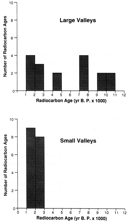
Figure 80--Periods of Holocene floodplain stability and soil formation in the Central Plains. Records are based on radiocarbon assays from the region. Sources: Present study (southwest Kansas); Mandel (1992b) (central Kansas); Artz (1983) and Mandel (1993b) (south-central Kansas); Mandel (1993a, b) (southeast Kansas); Bowman (1985), Johnson and Martin (1987), Mandel (1987), and Mandel et al. (1991) (northeast Kansas); Brice (1964) and May (1986, 1989, 1990) (central Nebraska); Martin (1990) (south-central Nebraska); Mandel (1985) (western Missouri); Artz and Reid (1984) and Hall (1977a-c) (northeast Oklahoma); Hall (1982), Lintz and Hall (1983), and Ferring (1986) (southwest Oklahoma).
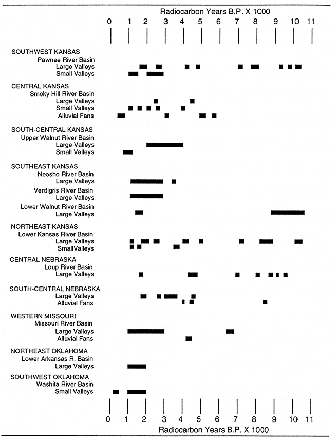
Within the main valley of the Pawnee River, soil formation was underway by at least 10,300-10,100 yr B.P., based on mean residence time for organic carbon from buried paleosols. This period coincides with the Pleistocene-Holocene transition in the Midwest: a time of major atmospheric circulation shifts that resulted in dramatic hydrologic changes. Deposits and associated soils of such antiquity have been documented at a few localities in the Central Plains, including Cooper's Canyon in central Nebraska (May, 1990), Bonner Springs in northeastern Kansas (Holien, 1982), and Waconda Lake in north-central Kansas (May, 1993) (fig. 80).
Mean residence time for humates from buried paleosols in large valleys of the Pawnee River suggests that the period 10,000-7,000 yr B.P. was punctuated by episodes of floodplain stability and soil development. A similar pattern of early Holocene soil development is indicated by radiocarbon assays from the Loup River basin of Nebraska and the Walnut and Kansas river valleys of Kansas (fig. 80).
Holocene valley fills in the Pawnee River basin are devoid of any indications of soil development between 7,000 and 5,000 yr B.P. (fig. 80). However, mean residence times for organic carbon from buried paleosols indicate soil formation on large, low-angle alluvial fans in the Smoky Hill River valley at ca. 5,100-5,300 and 5,750 yr B.P. (Mandel, 1992b), partially filling the gap in the middle Holocene paleosol record. Several studies suggest that the middle Holocene was a time of streamsystem instability or at least of low potential for strong soil development in the Central Plains (Johnson and Martin, 1987). For example, at the Coffey site in the Big Blue River valley of northeastern Kansas, Schmits (1980) recorded aggradation at ca. 6,300 yr B.P. May (1986) noted that alluvial fill at the Horn site on the South Loup River shows no evidence of soil development, in the form of buried paleosols, from ca. 7,000 to 4,780 yr B.P. Elsewhere in the South Loup River valley, Ahlbrandt et al. (1983) reported 10 radiocarbon ages from organic-rich zones in sandy alluvial fill. None of these dates, however, is within the period 7,000-5,000 yr B.P., suggesting an absence of floodplain stability and/or sufficient biomass for organic enrichment of sediment.
Radiocarbon assays suggest that soil formation was underway by at least 5,000 yr B.P. on floodplains of large valleys in the Pawnee River basin. Corroborative evidence for this episode of landscape stability once again comes from the Kansas and Loup river systems (fig. 80).
The timing of late Holocene floodplain stability and soil formation in the Pawnee River basin shows some variation according to the size of the streams. Radiocarbon assays indicate two discrete periods of paleosol development in large valleys: one at ca. 2,750-2,600 yr B.P. and another at ca. 2,000-1,600 yr B.P. (fig. 80). The older of these two episodes partially coincides with the soil-forming period radiocarbon-dated to ca. 2,800-2,000 yr B.P. in small valleys. However, the most recent episode of paleosol development in large valleys, 2,000-1,600 yr B.P., precedes the beginning of the major soil-forming period dated to 1,350-1,000 yr B.P. in small valleys. Hence late Holocene deposition appears to have been time-transgressive throughout the entire extent of the drainage basin.
Good indications of fluvial stability and soil formation during the late Holocene are found elsewhere in the Midwest, including the Central Plains (fig. 80). Late Holocene paleosols have been documented in the South Loup River valley in central Nebraska (May, 1986, 1989), the Republican River valley in south-central Nebraska (Martin, 1990), and the Smoky Hill River valley in north-central Kansas (Mandel, 1992b). Buried paleosols dating to the late Holocene are common in the valleys of tributaries to the Arkansas River in Kansas, including the Neosho, Verdigris, Fall, and lower Walnut rivers (Mandel, 1992a, 1993a, b).
There are exceptions to the synchronous pattern of fluvial stability and soil development in midwestern stream valleys during the Holocene. For example, an episode of soil development radiocarbon-dated to ca. 600-400 yr B.P. (Delaware Creek paleosol) in small stream valleys in southwestern Oklahoma (Ferring, 1986) has not been documented in the Central Plains. Similarly, a major episode of soil development dated to ca. 6,500-6,000 yr B.P. in the Des Moines River valley (Bettis and Hoyer, 1986) has not been recorded in central or southwestern Kansas.
Despite some variations in timing of erosion, sedimentation, and landscape stability, regional synchroneity is indisputable. For example, upland erosion and wholesale removal of sediment from small valleys occurred during the early and middle Holocene across much of the Midwest (Bettis et al., 1984). Sediment transported out of small valleys accumulated on alluvial fans and floodplains in large valleys. This episode of upland erosion and fan development has been documented in the lower Illinois River valley (Hajic, 1990; Wiant et al., 1983), the Des Moines River valley (Bettis and Benn, 1984; Bettis and Hoyer, 1986), the lower Smoky Hill River valley (Mandel, 1988b, 1992b), the Verdigris River system (Mandel, 1990a), and in large valleys of the lower Missouri River system (Ahler, 1973; Hoyer, 1980; Thompson and Bettis, 1980; Mandel, 1985). Sedimentation on fans was accompanied by aggradation in many large valleys, including the Wisconsin River valley in southern Wisconsin (Knox, 1972), the Des Moines River valley in central Iowa (Bettis and Hoyer, 1986), the Pomme de Terre River valley in west-central Missouri (Ahler, 1973; Haynes, 1976, 1977; Brakenridge, 1981), the South Loup River valley in central Nebraska (May, 1986, 1990), the Delaware River valley in northeastern Kansas (Mandel et al., 1991), and the lower Kansas River valley in northeastern Kansas (Johnson and Martin, 1987).
In summary, entrenchment and alluviation as well as periods of net transport and storage of sediment were diachronous in individual basins, but they were roughly synchronous in similar-sized parts of different basins. The products of these phenomena are differential preservation of Holocene deposits in different parts of individual drainage basins and broadly similar alluvial stratigraphic records across the region as a whole. The similarity in alluvial stratigraphic records is a function of broadly similar activity of streams in basins throughout the region during the Holocene. Forces that may be responsible for the pattern of Holocene fluvial activity are considered in the following discussion.
Stream responses to base-level changes
Raising and lowering the base level of a drainage basin cause aggradation and incision, respectively (Schumm, 1977, p. 70-74). Considerable attention has been given to the role of base-level changes in terrace formation (Schumm, 1977, p. 13-14, 70-74; Chorley et al., 1984, p. 334-335). Schumm (1977) demonstrated that the lowering of the base level creates a knickpoint in a stream profile that migrates upstream, successively rejuvenating tributaries as it does so. According to Chorley et al. (1984, p. 334), this can be viewed as a "wave of rejuvenation" that advances not only up the main channel but also up tributaries of decreasing rank order. In each valley the passage of the knickpoint leaves the incised previous floodplain as a terrace. Hence rejuvenation of a drainage basin resulting from base-level change has a significant influence not only on the drainage network but also on the valleys and channels. In addition, the increased sediment production may affect downstream areas, thereby causing aggradation (Schumm and Parker, 1973; Womack and Schumm, 1977).
It is likely that the Pawnee River basin was influenced by base-level changes in the Arkansas River valley during the Quaternary. Although sea-level changes probably had no effect on base levels of the Arkansas River in Kansas (Stewart, 1973), base-level changes in the Arkansas River valley may have occurred in response to downstream flood deposition or erosion. Unfortunately, no information is available on Holocene base-level changes in the Arkansas River valley of Kansas. Hence the influence of base-level changes on Holocene landscape evolution in the Pawnee River basin cannot be determined at this time.
Stream responses to tectonism
Tectonism in the form of uplift, subsidence, lateral displacement, and warping of the earth's crust produces channel incision, stream aggradation, progressive lateral shifting of a river channel, and cutoff meanders, respectively (Schumm, 1977, p. 100-101). However, as noted earlier, the Pawnee River is in the Central Stable Region of North America-an area that is not tectonically active. According to Schumm (1977, fig. 2-6), the rate of vertical movement of the crust in the Central Great Plains, including southwestern Kansas, is currently less than 1 mm/yr (0.04 in./yr). This rate may have been greater at times during the Holocene, thereby explaining some terraces in the Central Plains. According to Rogers (1984), dramatic Holocene uplift caused channel trenching and thus terrace formation in the Kansas and Arkansas River valleys of western Kansas.
Geophysical information collected by the Kansas Geological Survey suggests that the rate of uplift in southwestern Kansas was no greater at any time during the Holocene than it is today (Don Steeples, personal communication, 1988). This information combined with the diachronous pattern of Holocene erosion and sedimentation in the Pawnee River basin raises doubts about the role of tectonics in Holocene landscape evolution in the study area.
Stream responses to climatic change
Flowing water provides the energy with which streams erode, transport, and deposit sediment. Hence landscape evolution in a drainage basin is linked to changes in hydrologic variables affecting stream flow. Hydrologic variables are, in turn, responsive to changes in climate. Also, climate has a significant effect on vegetation density (Schumm, 1977, p. 25-26). The density of vegetative cover, in turn, affects surface runoff and erosion. Hence climatic change must be considered a major factor influencing landscape evolution in any river basin.
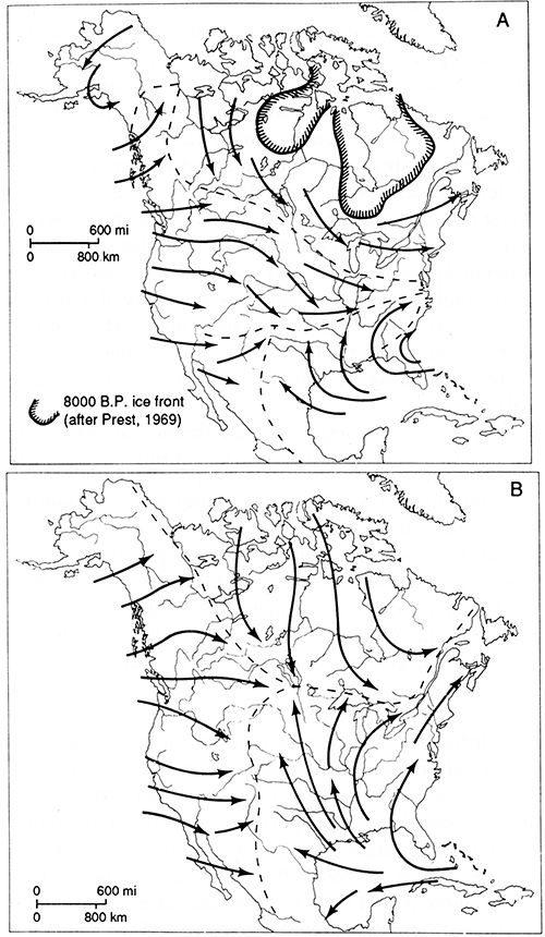
The alluvial chronology of the Pawnee River basin and other midwestern stream systems combined with paleoenvironmental data from the region suggests that wholesale removal of sediment from small valleys during the early and middle Holocene was a result of major bioclimatic change. Models of climatic conditions during this period indicate a trend toward warmer and drier conditions, apparently as a result of increased summer insolation (COHMAP Members, 1988) and stronger zonal air flow at the surface (Bryson and Hare, 1974; Kutzbach and Guetter, 1986; Kutzbach, 1987). Strong zonal flow restricted the northward penetration of moist tropical air masses into the Plains (fig. 81), thereby triggering the warm, dry Altithermal climate that prevailed in the Midwest from about 8,000 to 5,000 yr B.P. (Antevs, 1955; Deevey and Flint, 1957; Bryson et al., 1970; Webb and Bryson, 1972). The pollen record from Muscotah Marsh in northeastern Kansas documents an increase in grasses at the expense of trees during the Altithermal (Gruger, 1973). This interval of aridity caused prairies to expand far eastward into Missouri, Iowa, and Illinois (Brush, 1967; Wright, 1968, 1971; Durkee, 1971; King and Allen, 1977; Van Zant, 1979). As tall- and mixed-grass prairies in the Central Plains were replaced by sparser short-grass prairie, hillslopes would have been prone to erosion. It is also likely that frequent fires during this dry period removed ground cover and thereby accelerated erosion on hillslopes. Valley floors also would have been prone to erosion as ground-water levels in alluvial aquifers dropped, allowing streams to deeply incise their valley fill. In addition, the northward retreat of the Laurentide ice sheet during the early Holocene and the sharp northsouth temperature gradient at its southern margin probably triggered a change from frequent widespread but gentle rains associated with air-mass fronts to less frequent precipitation but more intense and erosive thunderstorms in the Midwest (Knox, 1983, p. 34).
Figure 81--Dominant air-flow patterns in North America during the Holocene. (A) Strong zonal westerly flow during the Altithermal [March resultant surface streamlines (after Bryson and Hare, 1974)]. (B) Meridional flow that has persisted since about 6,000 yr B.P. [June resultant streamlines (after Bryson and Hare, 1974)]. [From Knox (1983).]
The net effect of these climatic and vegetative changes would have been high erosion rates and large sediment yields in small streams during the early and middle Holocene (Bettis and Mandel, 1989). As Chorley et al. (1984, p. 53-54) pointed out, sediment delivery ratios are greater for small drainage basins than for larger ones under normal conditions. They attribute this inverse relationship to the following properties of small basins in relation to larger ones:
- Small valleys commonly have steeper side slopes and stream-channel gradients, encouraging more rapid rates of erosion.
- Small valleys lack broad floodplains, giving less opportunity for sediment storage in the basin after weathering and removal of sediment from slopes.
- Small basins may be totally blanketed by high-intensity storms, giving high maximum erosion rates per unit area.
Hence infrequent but intense thunderstorms during the Altithermal combined with sparse vegetative cover on hillslopes would have favored widespread erosion in small watersheds and transport of sediment out of small valleys and into larger ones. As the sediment supplied to the large valleys exceeded the conveyance capacity of streams, there would have been net increases in alluvial storage, with only a small portion of eroded sediment leaving the basin (Phillips, 1987). It is likely that alluviation and storage of sediment occurred both on fans and on floodplains in high-order stream valleys.
The change of atmospheric circulation from frequent zonal dominance during the early and middle Holocene to mixed zonal and meridional dominance during the late Holocene (fig. 81) influenced the regional distribution of vegetative communities and thus the activity of fluvial systems (Knox, 1983, p. 31). The increased frequency of meridional atmospheric circulation after ca. 4,000 yr B.P. is significant because it allowed warm, moist tropical air masses from the Gulf of Mexico to penetrate deep into the central Great Plains. Mean annual precipitation and large floods probably increased significantly because of frequent frontal activity in the collision zone between polar and tropical air masses (Knox, 1983, p. 39). As mean annual precipitation increased during the late Holocene, forests expanded across floodplains and hillslopes in the Midwest (Wright, 1971). Vegetation density increased in upland areas of the Central Plains as short-grass prairies were replaced by mixed- and tall-grass prairies. Denser vegetative cover would have promoted greater soil porosity and infiltration capacity. Altogether, the late Holocene vegetational change probably reduced erosion rates on hillslopes, which in turn would have reduced mean annual sediment concentrations in small streams. When stream loads were highest, during large floods, the forested floodplains would have trapped sediment and promoted alluvial storage in small valleys. Thus vegetative cover on floodplains partially accounts for the preservation of large volumes of late Holocene alluvium in low-order drainage elements. It is likely that elevated groundwater tables in alluvial aquifers also played a role in sediment storage. High water tables during the late Holocene would have reduced the depth of channel incision, thereby reducing sediment yields from small stream valleys.
Net sediment storage in small stream valleys during the late Holocene would have affected fluvial activity in large valleys. Because conveyance capacities of high-order streams were no longer satisfied by sediment imposed from tributaries, entrenchment and lateral channel migration into floodplain deposits of large valleys probably enhanced sediment loads in this part of the fluvial system.
There is no question that major bioclimatic changes affected Holocene landscape evolution in stream valleys of the Midwest, including the Great Plains. The development of alluvial fans during the early and middle Holocene is a case in point. However, when basinwide Holocene alluvial chronologies are examined, it is apparent that each erosional and depositional event did not occur in response to one external change, such as climate. Also, the number, magnitude, and duration of erosional and depositional events varied not only from valley to valley in the Midwest but also from area to area in the same basin. Thus fluvial events were not in phase everywhere, suggesting that some episodes of erosion, deposition, and landscape stability did not occur in response to a single external control.
Prev Page--Investigations, Small Valleys || Next Page--Summary
Kansas Geological Survey, Geology
Placed on web July 8, 2016; originally published 1994.
Comments to webadmin@kgs.ku.edu
The URL for this page is http://www.kgs.ku.edu/Publications/Bulletins/236/04_evolu.html