![]()
Prev Page--Contents || Next Page--Investigations, Large Valleys
Introduction
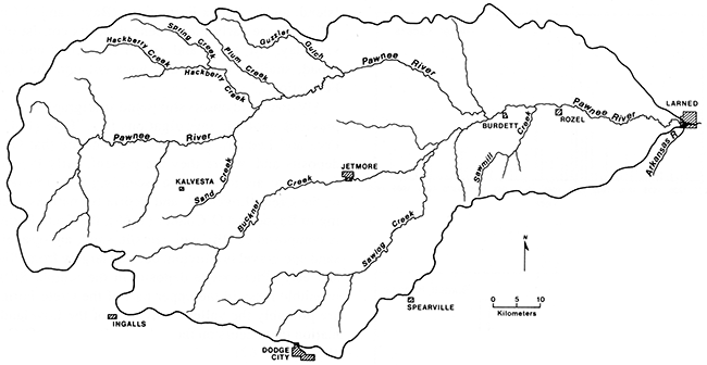
This study examines late Quaternary landscapes in the Pawnee River basin of southwestern Kansas (fig. 1). Before this investigation, limited geomorphologic research had been conducted in the Pawnee River system, but no systematic studies of late Quaternary landscapes had been undertaken in any drainage basin in southwestern Kansas. Hence little was known about the temporal and spatial relationships of Holocene erosion, alluviation, and landscape stability in the region. The lack of well-dated basinwide alluvial stratigraphic studies precluded evaluation of the driving forces behind landscape evolution in southwestern Kansas. By combining intensive and extensive absolute dating with a basinwide alluvial stratigraphic investigation, I have determined some of the controls and behavior of the Pawnee River fluvial system during the Holocene.
Figure 1--Location of Pawnee River basin (adapted from Kansas Geological Survey base map).
Goals and objectives of the research
The goals of this study are to infer causes of Holocene erosion, alluviation, and landscape stability and to define their temporal and spatial relationships in the Pawnee River drainage system. The three specific objectives of the research are (1) to determine the number of alluvial terraces in the valleys of the Pawnee River and its tributaries, (2) to establish the relative and absolute ages of terrace fills, and (3) to construct an alluvial chronology for the Pawnee River system and then compare it with other known Holocene alluvial sequences in the Midwest.
Significance of the research
This study is significant for several reasons. First, it contributes to our understanding of Holocene fluvial geomorphology and alluvial stratigraphy in the Midwest. Although a number of studies have provided information about the Pliocene and Pleistocene stratigraphy of southwestern Kansas [e.g., Smith (1940), Frye and Hibbard (1941), Frye et al. (1943), Frye (1945, 1948), and Frye and Leonard (1952)], little is known about Holocene alluvial landscapes in the region. Second, this study indirectly provides new information about rates of soil genesis in semiarid to dry subhumid environments. The time required for diagnostic horizons to form in soils of the Midwest is not clearly understood (Guccione, 1982; Birkeland, 1984, p. 205-209). This study provides extensive time control for alluvial fills and buried soils in the Pawnee River valley, permitting an approximation of pedogenic rates for modern and ancient alluvial soils. Finally, the research is important to understanding the archeology of the Midwest. Locating prehistoric cultural material in a rapidly evolving alluvial landscape is determined by the ability to analyze and understand the landscape and the processes that created it. By focusing on the extent and timing of erosion, alluviation, and landscape stability in the Pawnee River drainage system, this study should facilitate the discovery of cultural deposits.
Origin of the research problem
The problem of identifying causal factors of erosion, alluviation, and landscape stability in stream systems has been debated by Quaternary scientists since the nineteenth century. Before 1890 the development of nearly all alluvial terraces was attributed to movements of the Earth's crust [e.g., Dana (1864), Foster and Topley (1865), Lyell (1865), Home (1875), Whitaker (1880), and Hull (1878)]. Soon afterward, alluvial terraces were considered products of climatic variations (Gilbert, 1900; Johnson, 1901; Davis, 1902). Davis (1902), for example, suggested that a change of climate from humid to arid would lead to aggradation and steepening of stream gradients and that a change of climate from arid to humid would lead to trenching and a reduction in stream gradients. Later, Huntington (1914, p. 32) hypothesized that valley alluviation in arid and semiarid regions occurred during dry episodes, when vegetative cover was minimal and sediment yields were high. He suggested that a shift to a wetter climate would improve vegetative cover, reduce sediment load, and cause channel entrenchment. On the other hand, Bryan (1928) argued that channel entrenchment in the Southwest was associated with episodes of drought. He suggested that sparse vegetative cover during dry periods initiated channel entrenchment, which migrated upstream. Summaries of subsequent refinements of these hypotheses have been presented by Antevs (1952), Tuan (1966), and Cooke and Reeves (1976).
Hypotheses favoring climate as the primary cause of aggradation and degradation in river systems persist in recent literature. According to Knox (1983, p. 38), alluvial chronologies indicate that climatic changes and concomitant vegetational changes have contributed significantly to widespread synchronous episodes of aggradation and degradation. Although many researchers have focused on the possible contributions of climate as a cause of aggradation or degradation in river systems [e.g., Baker and Penteado-Orellana (1977), Knox (1972), Hall (1977a), Knox et al. (1981), Brakenridge (1981), and May (1986)], there is no consensus on the cause-and-effect relationships involved (Leopold, 1976; Patton and Schumm, 1981).
Schumm (1977, p. 74-81) pointed out that aggradation and degradation may also be related to a complex response of the fluvial system as thresholds intrinsic to the system are crossed. Patton and Schumm (1981) suggested that channel cutting and filling are a natural sequence of events by which sediment is episodically transported out of a drainage system. They concluded that, although major components of an alluvial chronology reflect major climatic changes, details of a chronology may reflect only episodic cut-and-fill processes.
Major valley fill sequences have not been absolutely dated in sufficient detail to resolve the controversy over causal factors of erosion, alluviation, and landscape stability. As more detailed alluvial stratigraphic studies are reported, it becomes obvious that the record is complex (Knox, 1983, figs. 3-9). This complexity may be a result of both the external and internal controls of the fluvial system.
Alluvial stratigraphy has been studied at a number of localities in the Midwest; some studies focused on specific sites (Ahler, 1976; Schmits, 1980), some on valley reaches (Bettis and Benn, 1984; Mandel, 1988a,b; Mandel et al., 1985), and others on entire drainage basins (Brice, 1964; Thompson and Bettis, 1980; Bettis and Hoyer, 1986; Bettis and Littke, 1987). Many of these studies have yielded stratigraphic information that may be used to reconstruct Holocene alluvial chronologies. Episodes of fluvial activity that produced terrace systems and alluvial fans in midwestern stream valleys are outlined in fig. 2.
Several observations can be made from examination of fig. 2. Although there is not an episode-to-episode correlation between any of the valleys, a general pattern is evident. Some valleys show major changes in fluvial activity approximately 10,500-10,000, 8,500-7,500, 4,500-3,000, 2,000-1,500, and 1,000-500 years ago. These ages correspond roughly to the end of the Late Glacial episode, the onset of the Atlantic episode, the end of the Sub-Boreal episode, the beginning of the Scandic episode, and the end of the Neo-Atlantic episode, respectively [see Bryson et al. (1970)]. In many cases it is apparent that different types of fluvial activity were occurring at the same time at different locations. For example, stream entrenchment occurred in the Des Moines valley of central Iowa between 10,000 and 8,000 yr B.P. (Bettis and Hoyer, 1986) while alluviation was taking place in the Perche and Hinkson river valleys of south-central Missouri (Mandel et al., 1985). In other cases similar geomorphic processes were underway at the same time in different drainage systems. For example, major alluvial fan development appears to be an early and middle Holocene phenomenon across the entire Midwest (Bettis et al., 1984). Alluvial fans stabilized between 3,000 and 2,000 yr B.P., and soils developed on their surfaces during the late Holocene. Geomorphic evidence from terrace fills also indicates a shift from aggradation to landscape stability and soil formation at 3,000-2,000 yr B.P. in the Midwest (Schmits, 1980; Artz, 1983, 1985; Mandel, 1985; Mandel et al., 1985; Johnson and Martin, 1987).
Figure 2--Alluvial episodes in Midwestern stream systems during the Holocene and late Pleistocene. A, alluviation; SA, slow alluviation; FA, fast alluviation; EN, entrenchment; E, erosion; AF, alluvial fan development; C, colluviation; SF, soil formation. (I) Northeastern Oklahoma, small valleys (Artz, 1985, 1988); (2) southwestern Oklahoma, small valleys (Ferring, 1986); (3) central Nebraska, large valley (May, 1986); (4) northwestern Missouri, large valley (Mandel, 1985); (5) north-central Missouri, large valley (Mandel et al., 1985); (6) west-central Missouri, large valley (Brakenridge, 1981); (7) western Iowa, small valleys (Thompson and Bettis, 1980); (8) central Iowa, large valley (Bettis and Hoyer, 1986); (9) southwestern Wisconsin, large valleys (Knox et al., 1981); (10) northeastern Kansas, large valley (Schmits, 1980); (11) south-central Kansas, large valley (Artz, 1983); (12) eastern Kansas, large valley (Johnson and Martin, 1987); (13) southwestern Kansas, small valleys (Mandel, 1988a).
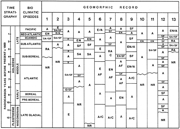
Detailed geomorphic research in portions of the Midwest indicates exceptions to these overall patterns of fluvial activity. The timing of a specific downcutting or alluviation episode may not have been the same in all portions of a drainage network. Likewise, certain types of deposition or erosional activity may have been concentrated in specific portions of a drainage system (Bettis and Benn, 1984). For example, in central and western Iowa alluvial fans were developing at the mouths of tributaries in major river valleys while erosion was occurring in the tributary valleys (Thompson and Bettis, 1980; Bettis and Hoyer, 1986). Deposits dating from the early and middle Holocene (8,500-4,500 yr B.P.) are found in alluvial fans of central Iowa, but middle Holocene deposits are not present in the small tributary valleys that were the sediment sources for the fans. The absence of middle Holocene alluvial deposits in tributary valleys may be due to high erosion rates and large sediment yields in these small drainage basins during that period.
Despite variations in the timing and nature of depositional processes, it is evident that the Midwest witnessed rough synchroneity of fluvial events during the Holocene. Many authors [e.g., Walker (1966), Knox (1972, 1976, 1985), Baker and Penteado-Orellana (1977), Brakenridge (1981), and Wendland (1982)] have suggested that climatic change is the underlying cause of the episodes of fluvial activity that produced the terrace systems in the region. There is no question that major climatic changes have affected erosional and depositional events, but examination of Holocene alluvial chronologies does not support the hypothesis that each depositional and erosional event occurred in response to one simultaneous external change, such as climate. Also, as noted in the previous discussion, the number, magnitude, and duration of erosional and depositional events varied not only from valley to valley in the Midwest but also within the same valleys. Thus fluvial events were not in phase everywhere, and it is apparent that some erosional and depositional episodes did not occur in response to a single external control. Part of the complexity of the midwestern fluvial record may be the consequence of tectonism, baselevel changes, vegetation disturbance, or simply a valley gradient exceeding a threshold value (Schumm, 1977, p. 77-84, 100-104). Furthermore, anyone of these extrinsic or intrinsic changes in a drainage network can trigger a complex response, such as a sequence of incision and alluviation, then modest incision downstream (Schumm, 1977, p. 74-77). Incision, therefore, may be episodic in response to a single change external to the fluvial system (Womack and Schumm, 1977).
To better understand stream response to intrinsic and extrinsic variables and the relationship with alluvial stratigraphy, one must carefully examine alluvial deposits and buried soils and radiocarbon-date them throughout the entire extent of drainage basins. Although some studies have covered entire basins [e.g., Thompson and Bettis (1980), Bettis and Littke (1987), and Mandel et al. (1991)], most studies have focused only on large valleys or small valleys [e.g., Brice (1964), Brakenridge (1981), and Hall (1982)]. The latter approach precludes an evaluation of both the linkages among various drainage elements composing a basin and the differences in stratigraphy and chronology that might be found in various parts of a basin. As Johnson and Martin (1987) pointed out, basinwide data are needed before the response of stream systems can be understood to the point where extrinsic and intrinsic parameters and time-transgressive elements can be sorted out. Toward this end, in the present study I focus on all levels of the Pawnee River drainage hierarchy, a large basin with many tributaries and extending from semiarid to dry subhumid environments.
Study area
Selection of the study area
The Pawnee River valley of southwestern Kansas was chosen for study primarily because it lies on a precipitation gradient from subhumid central Kansas to semiarid extreme western Kansas. This is important because climatic changes are most easily detected along climatic gradients (Birkeland, 1984, p. 305) and because changes between subhumid and semiarid climates produce great variability in runoff and sediment yield from hill slopes (Langbein and Schumm, 1958; Knox, 1972, 1983). The Pawnee River also was selected for study because of the numerous stream bank exposures throughout the upper and middle reaches of the drainage basin. Many of these exposures provide opportunities to examine alluvial stratigraphic sequences to depths exceeding 6 m (20 ft).
Location and physiography
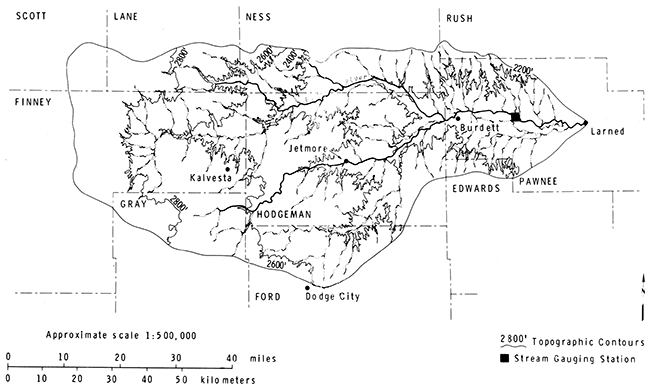
The study area includes the Pawnee River basin in Edwards, Finney, Gray, Hodgeman, Ford, Ness, Lane, Pawnee, Rush, and Scott counties in southwestern Kansas (fig. 3). The sites actually investigated were confined to floodplains and terraces in valley bottoms of the Pawnee River and its tributaries.
Figure 3--Pawnee River basin and county boundaries and relief [from Sophocleous (1980)].
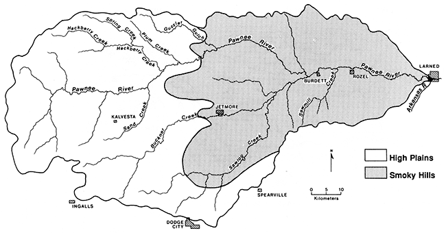
The Pawnee River originates in the High Plains section of the Great Plains physiographic province (Fenneman, 1931) (fig. 4). The river flows eastward through the extreme southwestern portion of the Smoky Hills physiographic subprovince before it joins the Arkansas River.
Figure 4--Pawnee River drainage basin and physiographic regions [adapted from Schoewe (1949)].
In the headwater area of the Pawnee River the topography of the High Plains generally is flat. The High Plains surface gradually slopes eastward at a rate of about 1.5 m/km (8 ft/mi) (Frye and Leonard, 1952, p. 201). Shallow, undrained depressions, with diameters ranging from a few meters to several kilometers, are scattered across upland areas of the High Plains (Frye, 1950). Most of these depressions are less than 3 m (10 ft) deep, although some larger ones have depths of 15-20 m (49-66 ft),
The Pawnee River valley is 1-2 km (0.6-1.2 mi) wide, and the level of the floodplain is 20-30 m (66-98 ft) below the High Plains surface in the extreme western portion of the drainage system. However, the valley becomes much wider and deeper along the eastern margin of the High Plains. Sections of the valley bottom in Ness and Hodgeman counties are as great as 6.5 km (10 mi) wide, and the floodplain is 40-60 m (130-200 ft) below the upland surface.
Because the major drainage of the area is toward the east, the stream divides trend and slope eastward. The southern flanks of the divides slope gently to the Pawnee River and its major tributaries, but the northern flanks have short, steep slopes. The Pawnee River flows through a deep, wide valley as it crosses the Smoky Hills. The valley is flanked by pediments (Frye and Leonard, 1952, p. 203), and erosion of the Niobrara Chalk has produced high, flat-topped buttes and mesas in some locations. There is as much as 75 m (250 ft) of relief in this portion of the drainage basin.
As the Pawnee River enters the Arkansas River valley, the landscape becomes an undulating plain with little relief. Thick deposits of alluvial sands and gravels underlie the broad valley floor of the Arkansas River. In some areas winds have swept the sands into low rolling dunes (Frye and Leonard, 1952, p. 141; Merriam, 1963, p. 164).
Hydrology
The Pawnee River is a long, fairly wide west-east-trending drainage system (fig. 5). The Pawnee River and its tributaries drain an area of approximately 3,975 km2 (1,535 mi2) into the Arkansas River. Principal tributaries of the Pawnee River are Hackberry, Buckner, and Saw log creeks (fig. 5).
Figure 5--Pawnee River drainage basin and major tributaries.
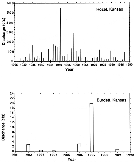
The discharge of the Pawnee River has been measured by the U.S. Geological Survey near Burdett and Rozel, Kansas, since October 1, 1981, and April 24, 1924, respectively. The average discharge of the Pawnee River for an eight-year period (1981-1989) near Burdett was 3.6 cubic feet per second (cfs) (fig. 6); the maximum discharge for this period of record was 1,550 cfs on July 6, 1987 (U.S. Geological Survey, 1990). No flow was recorded for most days at the Burdett gaging station. The average discharge of the Pawnee River for a 61-year period (1928-1989) near Rozel was 68.9 cfs (fig. 6); the maximum discharge for this period of record was 16,300 cfs on July 28,1958 (U.S. Geological Survey, 1990). The Rozel gaging station recorded lengthy periods of no stream flow for most years.
Figure 6--Hydrographs for the Pawnee River at Rozel and Burdett, Kansas (U.S. Geological Survey, 1990).
Residents along the middle and lower reaches of the Pawnee River reported that, before the development of pump irrigation in the 1930's, the river flowed continuously. Subsequently, wells along the Pawnee River valley have lowered the water table of the alluvial aquifer below the river bed. Hence water moves from the stream to the aquifer during periods of streamflow resulting from precipitation (Jenkins and Pabst, 1977). In addition, pumping along the valley intercepts ground water that would have moved toward the stream, thereby resulting in depletion of base flow. The discharge of the Pawnee River also has been reduced by surface-water diversions for irrigation and by the construction of erosion-control dams across many small tributaries.
Geology
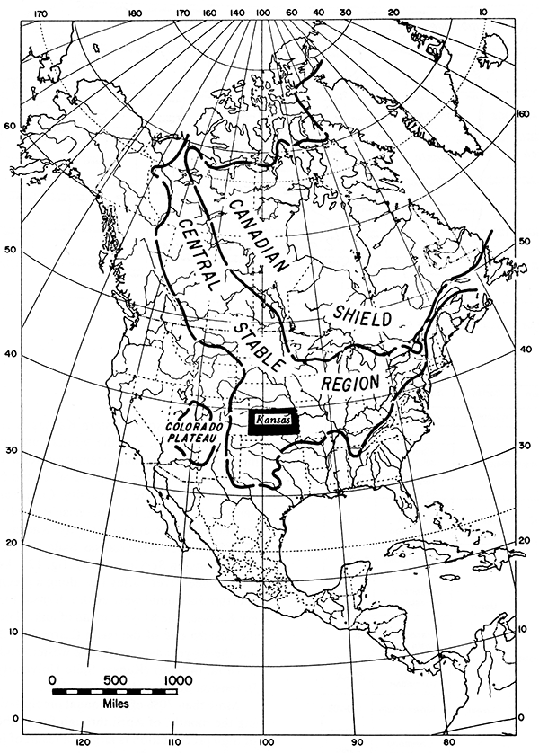
Southwestern Kansas, including the area of the Pawnee River drainage system, is located on a platform-like extension of a large craton that forms the Central Stable Region of North America (fig. 7). This situation has persisted since the end of the Precambrian, and only a thin mantle of sedimentary rock covers the basement complex (Merriam, 1963, p. 179). The Precambrian basement complex actually is a buried extension of the Canadian Shield (Eardley, 1951).
Figure 7--Relationship of Kansas to the Canadian Shield and Central Stable Region [from Merriam (1963, p. 14)].
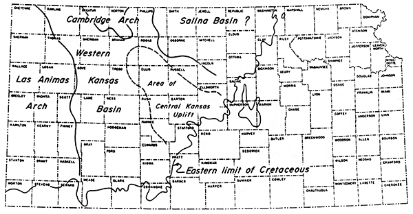
The Pawnee River drainage system is within the Western Kansas basin, which is a major structural feature of the central Great Plains (fig. 8). This basin is approximately 160 km (100 mi) wide and 350 km (220 mi) long and extends into southern Nebraska. The Western Kansas basin is a broad syncline that formed during the Mesozoic in the area of the Hugoton embayment (Merriam, 1963, p. 183). The downwarp plunges gently northward between the area of the Central Kansas uplift, the Cambridge arch to the east, and the Las Animas arch to the west. Merriam (1963, p. 183) suggested that the basin was a result of Cretaceous tilting to the northwest into the Denver basin in eastern Colorado and southwestern Nebraska.
Figure 8--Major structural features of Kansas [from Merriam (1963, p. 178)].
The surface bedrock in the study area is sedimentary in origin, primarily consisting of limestone, chalk, shale, and sandstone. All these surface rocks are Cretaceous in age, and they are exposed only in outcrops along major stream valleys. Rocks of Early Cretaceous age crop out in the eastern and southeastern portions of the Pawnee River basin. The Lower Cretaceous Series is composed of the Cheyenne Sandstone, the Kiowa Shale, and the Dakota Formation (fig. 9). These formations largely consist of interbedded shales, siltstones, mudstones, and sandstones (Merriam, 1963).
Figure 9--Geologic column for southwestern Kansas [adapted from Sophocleous (1980)].
| System | Series | Subdivision | Thickness (ft) |
|---|---|---|---|
| Quaternary | Holocene | Alluvium | 0-60 |
| Pleistocene | Loess | 0-10 | |
| Floodplain Alluvium |
0-135 | ||
| Terrace Deposits |
0-150 | ||
| Tertiary | Pliocene | Ogallala Formation |
0-100 |
| Cretaceous | Upper | Carlile Shale | 0-100 |
| Greenhorn Limestone |
0-125 | ||
| Graneros Shale |
20-36 | ||
| Lower | Dakota Formation |
20-300 | |
| Kiowa Shale |
100-200 | ||
| Cheyenne Sandstone |
15-50 |
The Upper Cretaceous Series in southwestern Kansas primarily consists of marine shales and limestones (Merriam, 1963). The formations in this series include the Graneros Shale, the Greenhorn Limestone, the Carlile Shale, and the Niobrara Chalk (fig. 9). These formations crop out in stream valleys throughout the study area (fig. 10).
Figure 10--Surface geology of the Pawnee River basin [from Sophocleous (1980)].
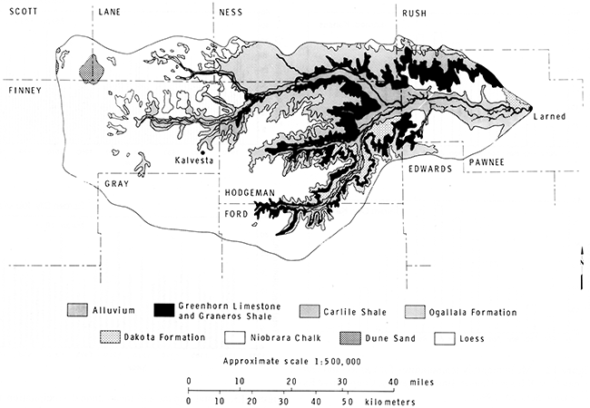
The surface bedrock in the High Plains section of the study area is mantled by the Pliocene-age Ogallala Formation at many localities (fig. 10). The Ogallala Formation ranges from several centimeters to more than 300 m (980 ft) in thickness (Gutentag et al., 1981). This formation consists of alluvial gravel, sand, silt, and clay and is largely unconsolidated. However, the Ogallala is cemented by calcium carbonate into "mortar beds" at some localities (Frye et al., 1956). The sediment making up the Ogallala deposits was derived from erosion of older rocks to the west, chiefly from the flanks of the Rocky Mountains, and of local bedrock (Frye and Leonard, 1952, p. 181). Clasts primarily consist of feldspar, quartz, granite, and fragments of other igneous and metamorphic rocks.
In some areas of the Pawnee River basin, especially in Ness and Hodgeman counties, the Ogallala Formation is mantled by deposits of the Holdrege, Fullerton, Grand Island, and/or Sappa Formations (Bayne and O'Conner, 1968). These early Pleistocene deposits consist of alluvial clay, silt, sand, and gravel that filled and capped broad, shallow valleys that were cut into the Ogallala Formation.
My own field observations and stratigraphic data from previous geologic investigations [e.g., Frye (1945) and Frye and Leonard (1951, 1952)] indicate that Ogallala deposits and, where they are present, early Pleistocene formations are mantled (in ascending order) by deposits of the Crete, Loveland, and Peoria formations. According to Bayne and O'Conner (1968), the Crete Formation is composed of Illinoian-age silt, sand, and gravel. The sand and gravel is alluvium derived largely from Pliocene and early Pleistocene deposits in the region. Silts that resemble loess in the upper part of the Crete Formation are probably the valley equivalent of the Loveland Formation that occurs on the uplands (Bayne and O'Conner, 1968, p. 66-67).
The Loveland Formation in southwestern Kansas consists of yellowish-brown Illinoian-age loess with minor amounts of alluvium (Bayne and O'Conner, 1968). The texture of the loess ranges from silt loam to very fine sandy loam, and it generally is calcareous. There is a strong brown to reddish-yellow paleosol developed at the top of the Loveland Formation. Frye and Leonard (1951; 1952, p. 119) considered this paleosol a Sangamon soil. The paleosol is truncated down to or into the B horizon. Evidence of truncation is the absence of an A horizon in all sections and a concentration of fine, rounded quartz pebbles at the top of the paleo-B horizon at some localities (Gamble, 1988).
The Peoria formation mantles the truncated paleosol at the top of the Loveland Formation or occurs directly above Cretaceous bedrock, Tertiary deposits, or early Pleistocene deposits. The Peoria formation is composed of brown to pale-brown Wisconsinan-age loess (Bayne and O'Conner, 1968). The texture of the Peoria in the study area generally ranges from loam to light silty clay loam, and it tends to become gritty in its lower part (Gamble, 1988). The Peoria loess is highly calcareous and often contains many soft calcium carbonate concretions. Modern surface soils are developed in the upper part of the Peoria formation.
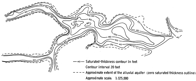
Large volumes of Quaternary alluvium are stored in valley bottoms of the Pawnee River and its major tributaries (Sophocleous, 1980). Valley cross sections prepared by Fishel (1952) indicate that alluvial fill in the lower two-thirds of the drainage system is as thick as 50 m (164 ft) in some areas. The large volume of alluvium in the main valley of the Pawnee River also is indicated by the great saturated thickness of the alluvial aquifer (fig. 11). Little is known, however, about the absolute age of the Quaternary deposits composing the valley fill of the Pawnee River.
Figure 11--Saturated thickness of valley fill in the central and eastern portions of the Pawnee River basin, 1945-1947 [from Sophocleous (1980)].
Climate
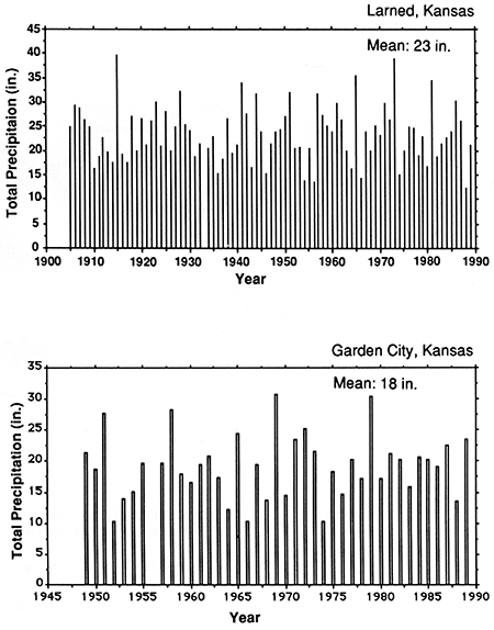
The climate of southwestern Kansas is continental; the summers are hot, and the winters are cold. The mean monthly July and January temperatures at the eastern end of the Pawnee River basin are 80.2° and 30.4°F, respectively (Kansas State University, Cooperative Extension Service, 1990) (fig. 12). The mean monthly July and January temperatures at Garden City, Kansas, are 80.0° and 27.5°F, respectively (Kansas State University, Cooperative Extension Service, 1990) (fig. 12). As noted earlier, the Pawnee River valley lies along a precipitation gradient from subhumid west-central Kansas to semiarid western Kansas. The 81-year mean of annual precipitation for the eastern end of the basin (Larned) is 23 in. (60 cm), and the 40-year average for the western end (Garden City) is 18 in. (48 cm) (Kansas State University, Cooperative Extension Service, 1990) (fig, 13).
Figure 12--Mean monthly temperatures for Larned and Garden City, Kansas (Kansas State University, Cooperative Extension Service, 1990).
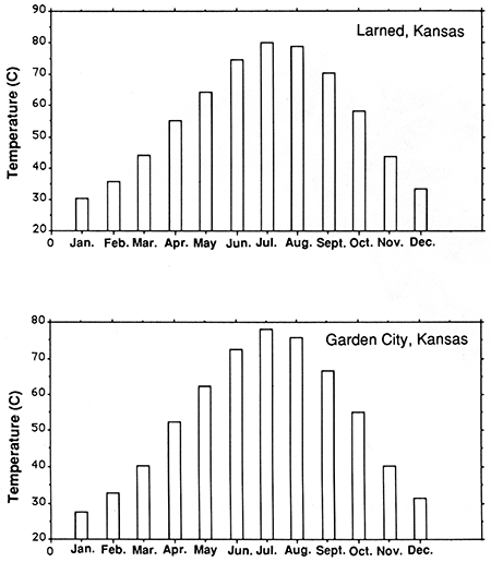
Figure 13--Total annual and mean annual precipitation for Larned and Garden City, Kansas (Kansas State University, Cooperative Extension Service, 1990).
More than 70% of the annual precipitation occurs during the months of April through September. This period of high precipitation is largely a result of frontal activity. Maritime polar (mP) and continental polar (cP) air masses that flow into southwestern Kansas during late spring and early summer often converge with warm, moist maritime tropical (mT) air flowing north from the Gulf of Mexico. The overrunning of mP and cP air by warmer mT air often produces intense rainfalls of short duration along the zone of convergence. Convectional thunderstorms during the late summer months also can produce heavy rainfalls.
The winter weather patterns in southwestern Kansas generally are unfavorable for high precipitation. The region is dominated by dry westerly and northerly air flow from December to the end of February. Cyclonic frontal cells associated with invading Pacific air masses periodically bring heavy snowfall to the region, but monthly averages rarely exceed 10 cm (4 in.).
Weather patterns in southwestern Kansas have a tendency to produce frequent droughts. Severe droughts afflict the region about every 20 years, extending semiarid conditions eastward into central Kansas (Bark, 1961). The most severe droughts seem to occur during alternate dry periods (Borchert, 1971, p. 2-6). Borchert (1950) suggested that drought occurs when the strong westerlies of winter persist into spring and summer. Intensification of westerly air flow in the upper atmosphere has the effect of blocking the northward penetration of moist Gulf air into the midcontinent (Bryson and Hare, 1974, p. 4), thereby promoting drought.
Vegetation
The study area is within the Interior Grasslands region of North America. Although this region once was regarded as a vast, homogeneous grassland, Kuchler (1964, 1967, 1974) identified several distinct north-south-trending grassland associations in central North America. The increase in elevation and the decrease in mean annual rainfall from east to west have a strong influence on the composition and overall appearance of these associations. The western limit of the Interior Grasslands is bounded by the Rocky Mountains. Abutting the mountains is the shortgrass prairie, which extends eastward across the High Plains of western Kansas. The short-grass prairie is gradually replaced by mixed-grass prairie at the eastern edge of the High Plains. There is a transition from mixed-grass prairie to tall-grass prairie along the western boundary of the Flint Hills region. The tall-grass prairie stretches eastward to its boundary with the Eastern Deciduous Forest.
The western quarter of the Pawnee River valley is within the short-grass prairie (fig. 14). Uplands in this area are dominated by blue grama (Bouteloua gracilis) and buffalo grass (Buchloe dactyloides). Hairy grama (Bouteloua hirsuta) takes over on rocky outcrops, and topographic breaks are often enriched with little bluestem (Andropogon scoparius) and other medium-tall grasses (Kuchler, 1967, p. 396). Tall grasses, such as big bluestem (A. gerardi), are common in depressions and along floodplains during moist years. Freshwater marshes are dominated by forbs and sedges, including prairie cordgrass (Spartina pectinata) and prairie bullrush (Scirpus paludosus).
Figure 14--Generalized vegetation map of the Pawnee River basin [adapted from Kuchler (1974)].
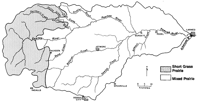
Forested areas are rare in short-grass prairies, except along rivers and on escarpments and other topographic breaks. Riparian forests are dominated by cottonwood (Populus deltoides) and willow (Salix spp.). These trees are widely spaced in the beds of most intermittent streams. The understory may consist of grasses, including blue grama, buffalo grass, and sand dropseed (Sporobolus heterolepis). Where grasses are few or absent, sunflower (Helianthus spp.), chenopods (Chenopodium spp.), Russian thistle (Salsola pestifer), and other weeds often form the lower story of vegetation.
The eastern three-quarters of the study area is within the mixed-grass prairie of the Interior Grasslands (fig. 14). This prairie forms a north-south-trending band through west-central Kansas and extends westward on the breaks in the dissected parts of the High Plains. The mixed-grass prairie consists of graminoids and forbs, often with two distinct layers: one of low-growing grasses and one of medium-tall grasses and forbs (Kuchler 1974, p. 591). The vegetation is characterized by a mixture of tall and short grasses, with the dominant species being big and little bluestern, sideoats grama (Bouteloua curtipendula), and blue grama. Other common components include western wheatgrass (Agropyron smithii), June grass (Koeleria pyramidata), panic grass (Panicum scribnerianum), and red three-awn (Aristida longiseta).
The wooded areas in the mixed-grass prairie have more species of trees than those in the short-grass prairie to the west. Cottonwood, willow, juniper (Juniperus virginiana), burr oak (Quercus macrocarpa), and hackberry (Celtis occidentalis) are widely spaced along streams and rivers, and few herbs are present in the understory.
Research methods
Data requirements
Because there have been no previous geomorphologic investigations of the Pawnee River valley, I had to acquire data concerning alluvial landforms, stratigraphy, sedimentology, and chronology from field and laboratory studies. There were several sources of existing data that proved useful, including bulletins and reports published by the Kansas Geological Survey, soil surveys prepared by the U.S. Department of Agriculture Soil Conservation Service (SCS), unpublished water-well logs held by private companies, and streamflow observations recorded by the U.S. Geological Survey. In addition, landscape data were gleaned from the U.S. Geological Survey 7.5-minute topographic maps and 1:5,000-scale stereographic air photos supplied by the SCS. Also, useful historical data were obtained from local landowners, including information about flooding, lateral migration of stream channels, and gullying.
Strahler's (1964) drainage classification system was used to determine stream orders on the 7.5-minute topographic maps. Only those drainage elements shown as dashed or solid blue lines on the maps were rank-ordered.
Field and laboratory methods
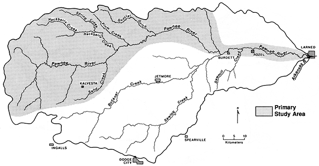
The field investigation initially involved reconnaissance of the primary study area (fig. 15). At this early stage of the study landforms identified on topographic maps and air photos were field-checked. The stages in the selection of individual geomorphic study sites were as follows. First, the locations of stream cutbanks that expose buried cultural deposits or deep stratigraphic sequences in terrace fills were recorded. Emphasis was placed on locating buried cultural deposits because they often yield material for relative and numerical [carbon-14 (14C)] dating. Second, cutbanks that clearly show stratigraphic relationships of alluvial fills in first-order through sixth-order stream valleys within the primary study area were selected for detailed description, sampling, and radiocarbon dating. In addition, alluvial stratigraphic sequences were examined at several locations outside the primary study area for comparison. This field strategy concentrated on the large area of the Pawnee River drainage system, yet it provided an opportunity to construct detailed alluvial stratigraphic records for subbasins that vary in size.
Figure 15--Primary study area within the Pawnee River basin.
In addition to examining stream cutbanks, I examined alluvial deposits by coring with a Giddings Hydraulic Soil Probe. Cores were taken along cross-valley transects in the lower, middle, and upper reaches of the Pawnee River drainage system. Most of the transects extended away from stream cutbanks that were selected for detailed analyses. Cores were used to determine the character, depth, and extent of deposits underlying the various landforms in the Pawnee River valley and to establish spatial relationships between the fills. Cores were especially useful for tracing disconformities and buried soils along cross-valley transects. In most cases undisturbed continuous cores, either 5.0 or 7.6 cm (2.0 or 3.0 in.) in diameter, were taken down to the base of alluvial fills. Cores were taken as deep as possible in several locations where the bedrock could not be reached with the probe. After briefly describing the cores in the field, I placed the cores in PVC tubes for transport to the laboratory for detailed analyses.
Cross sections of the stream valleys were constructed for study sites from 7.5-minute topographic maps. In addition, valley-bottom cross sections were surveyed with a hand level, measuring rod, and fiberglass tape. The cross sections were used in the field in conjunction with enlarged 7.5-minute topographic maps of each study site to map the spatial extent of landforms. The resulting field maps provided information on the relative degree of preservation of both the terraces and the underlying valley fill.
Surfaces of alluvial landforms were numbered consecutively from stream level upward, with the modern floodplain designated T-0, the first terrace T-1, and the highest terrace T-3. At some places along the Pawnee River and its tributaries, the modern floodplain is a complex consisting of two surfaces separated by a short scarp. In this case the lowest floodplain surface was designated as T-0a and the slightly higher one as T-0b.
Soils exposed in cores and stream cutbanks were described using standard U.S. Department of Agriculture terminology and procedures (Soil Survey Staff, 1990). Each soil horizon was described in terms of its texture, Munsell matrix color and mottling, structure, and boundaries. When present, root channels, clay films, matrix carbonate, and ferromanganese concretions were described. Reaction of soils to 10% HCl was noted, and stages of carbonate morphology (Table 1) were defined according to the classification scheme of Birkeland (1984). In addition, sedimentary features preserved in C horizons of some soils were examined to help reconstruct depositional histories.
Table 1--Stages of carbonate morphology for nongravelly sediment
| Stage | Properties |
|---|---|
| I | Few filaments or coatings on sand grains; <10% calcium carbonate |
| I+ | Filaments are common |
| II | Few to common nodules; matrix between nodules is slightly whitened by calcium carbonate (15-50% by area) that occurs as veinlets and filaments; some matrix can be noncalcareous; 10-15% calcium carbonate in whole sample, 15-75% in nodules |
| II+ | Common nodules; 50-90% of matrix is whitened; 15% calcium carbonate in whole sample |
| III | Many nodules; calcium carbonate coats so many grains that over 90% of horizon is white; carbonate-rich layers more common in upper part; about 20% calcium carbonate |
| III+ | Most grains coated with calcium carbonate; most pores plugged; >40% calcium carbonate |
| IV | Upper part of K horizon is nearly pure cemented calcium carbonate (75-90% calcium carbonate) and has a weak platy structure because of weakly expressed laminar depositional layers of calcium carbonate; rest of horizon is plugged with calcium carbonate (50-75% calcium carbonate) |
| V | Laminar layer and platy structure strongly expressed; incipient brecciation and pisolith formation (thin multiple layers of calcium carbonate surrounding particles) |
| VI | Brecciation, recementation, and pisoliths common |
| Source: Birkeland (1984, table A-4). | |
Soil and sediment samples were collected from two cutbanks to determine particle-size distribution and calcium carbonate equivalent. Soils were sampled by horizon using standard U.S. Department of Agriculture procedures (Soil Conservation Service, 1984). Alluvial units were systematically sampled at intervals that depended on their thickness (Krumbein and Graybill, 1965). Particle-size distribution was determined using the pipette method (Soil Conservation Service, 1984, p. 15-17) and dry-sieving of sand. The Chittick gasometric method (Dreimanis, 1962) was used to determine calcium carbonate equivalent.
Charcoal, bone, and bulk soil samples were submitted to the University of Texas Radiocarbon Laboratory for 14C analysis. All samples were pretreated by the radiocarbon laboratory to remove roots and calcium carbonate.
Radiocarbon ages determined on humates are mean residence times for all organic carbon in the soil samples (Campbell et al., 1967). Although mean residence time does not provide the absolute age of a buried soil, it does give a minimum age for the period of soil development, and it provides a limiting age on the overlying material (Geyh et al., 1975; Scharpenseel, 1975; Birkeland, 1984, p. 150; Haas et al., 1986).
Stratigraphic framework
A bipartite stratigraphic nomenclature is used in this study. Stratigraphic designations are informal and include stratigraphic units and soils. At all research localities in the study area, the boundaries of stratigraphic units are marked by the upper boundary of surface soils or buried paleosols. However, not all buried paleosols served as boundaries for stratigraphic units. Instead, only those with morphologically well-expressed horizons were selected. Not only do the better developed soils indicate longer periods of relative stability (disconformities) separating periods of aggradation, but they also are easily traced along longitudinal and cross-valley transects. Thin, weakly developed buried soils observed in some exposures were not observed in other exposures of the same fill in a stream valley; that is, they were not laterally traceable; hence these soils were not used as boundaries for stratigraphic units. Roman numerals designate the stratigraphic units, beginning with I at the top of a section. The individual units are site specific and do not always represent the same deposits at different localities.
Stratigraphic units recognized in this study are similar to allostratigraphic units of the North American Stratigraphic Code. Allostratigraphic units are mappable stratified bodies of sedimentary rock or sediments whose boundaries are laterally traceable disconformities (North American Commission on Stratigraphic Nomenclature, 1983). The system used in the present study is not as rigid as that of the North American Stratigraphic Code, yet it effectively places bodies of sediment into a stratigraphic framework.
Soils were included in the stratigraphic framework of each vertical section described in the study area. Soils are important to the subdi vision of Quaternary sediments, whether the soils are at the present land surface or buried (Birkeland, 1984, p. 325). After soils were identified and described, they were numbered consecutively, beginning with 1, the modern soil, at the top of the section.
Identification of buried soils
The identification of buried soils in late Quaternary valley fill was crucial to inferring intervals of floodplain stability in the Pawnee River basin. However, recognition of buried paleosols was complicated by (1) truncation of soils by erosion before burial, (2) diagenesis of soil horizons after burial, and (3) deposition of organic- and/or clay-rich alluvium that was not subsequently modified by soil genesis. Therefore several criteria were used to differentiate buried soils from unmodified alluvium. These criteria are [after May (1986)]:
- Color. Modern A horizons in southwestern Kansas tend to have a moist Munsell (1975) value of 4.0 or less and a chroma of 3.0 or less. In the present study buried A horizons must meet these criteria. Also, the dry value or chroma of a buried A horizon must be less than that of the overlying or underlying soil horizon or sediment.
- Lower boundary. The lower boundary of a modern soil generally is clear, gradual, or diffuse, whereas depositional units that have not been altered by pedogenesis have an abrupt lower boundary. Hence the lower boundary of a buried soil cannot be abrupt.
- Structure. The bonding together of individual soil particles produces structure. Individual aggregates, or peds, are classified into several types on the basis of shape (i.e., granular, blocky, columnar, and prismatic). Buried paleosols must therefore show evidence of structure. However, this criterion cannot be used alone to differentiate buried soils from depositional units. Flood drapes often are composed of high proportions of clay that are rich in 2:1-Iayered silicate minerals. The shrinking and swelling of these clays gives the alluvial deposits an angular-blocky structure.
- Clay films. Clay films lining ped surfaces or voids are good evidence of clay illuviation and B horizon development in modern soils. Hence detection of clay films with a hand lens was a criterion used to identify buried paleosols, especially truncated paleo-Bt horizons. Like structure, this criterion cannot be used alone to differentiate paleosols from alluvial deposits. Pressure faces on aggregates of clay-rich alluvium closely resemble clay films when viewed with a hand lens.
- Evidence of bioturbation. Modern soils generally have evidence of bioturbation. This evidence may consist of krotovinas, worm casts, or root channels. Thus buried paleosols should show some evidence of bioturbation.
- Lateral extent. True soils are laterally extensive and are not restricted to particular landforms. They can cross lithologic discontinuities and, in valleys, can be traced from abandoned channels to natural levees and from terraces onto valleyside slopes. Thus a buried soil can be mapped in three dimensions over varying topography, whereas a depositional unit is restricted to a particular landform.
The terms soil and deposit should not be confused. The term soil is often used by engineers to represent any deposit of unconsolidated rock material (regolith). Archeologists also commonly use this term when referring to the medium from which artifacts are recovered. In this study, deposit refers to a package of sediment, and soil refers to the zones within a deposit that have been altered by soil-forming processes.
Prev Page--Contents || Next Page--Investigations, Large Valleys
Kansas Geological Survey, Geology
Placed on web July 8, 2016; originally published 1994.
Comments to webadmin@kgs.ku.edu
The URL for this page is http://www.kgs.ku.edu/Publications/Bulletins/236/02_intro.html