![]()
Prev Page--Investigations, Large Valleys || Next Page--Evolution
Geomorphic and stratigraphic investigations, continued
Small valleys
Locality BC-1
Locality BC-1 is situated in Buckner Creek valley, 46 km (29 mi) upstream from the confluence of that creek with the Pawnee River (fig. 16). Buckner Creek is a fourth-order stream and has a gradient of 3.3 m/km (17 ft/mi) at this locality. The valley trends eastwest and is asymmetric, with steep north-facing slopes and gentle south-facing slopes.
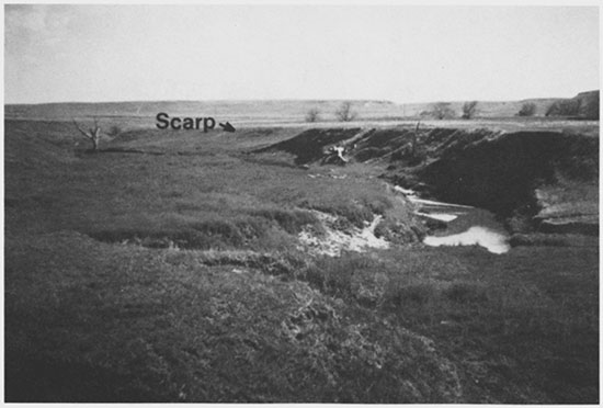
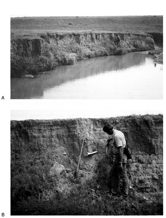
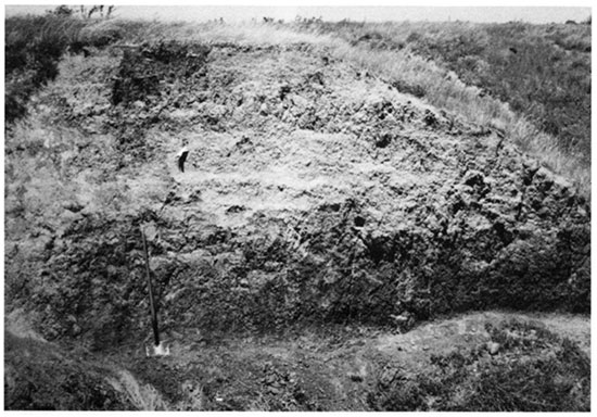
The valley floor at locality BC-1 is 50-200 m (164- 656 ft) wide and is composed of two landforms: the modern floodplain (T-0) and a low terrace (T-1) (fig. 52). T-1 is a paired terrace throughout most of this locality and is separated from T-0 by a short, steep 3-m-high (10-ft-high) scarp (fig. 53). In some sections of the valley, however, the T-1 terrace has been removed as a result of lateral migration by Buckner Creek. Hence the side slopes of the valley descend to the T-1 surface or merge with the modern floodplain (fig. 52).
Figure 52--Landform map of locality BC-1 showing locations of sites 14HO306 and 14HO315.
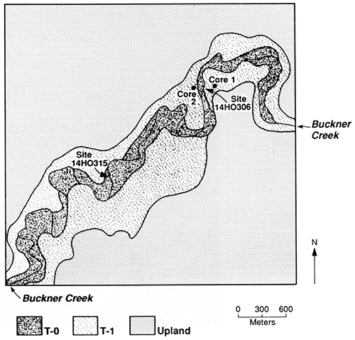
Figure 53--Valley floor of Buckner Creek at locality BC-1. Note the scarp separating the T-0 surface from that of T-1.
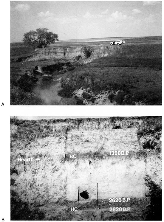
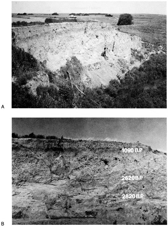
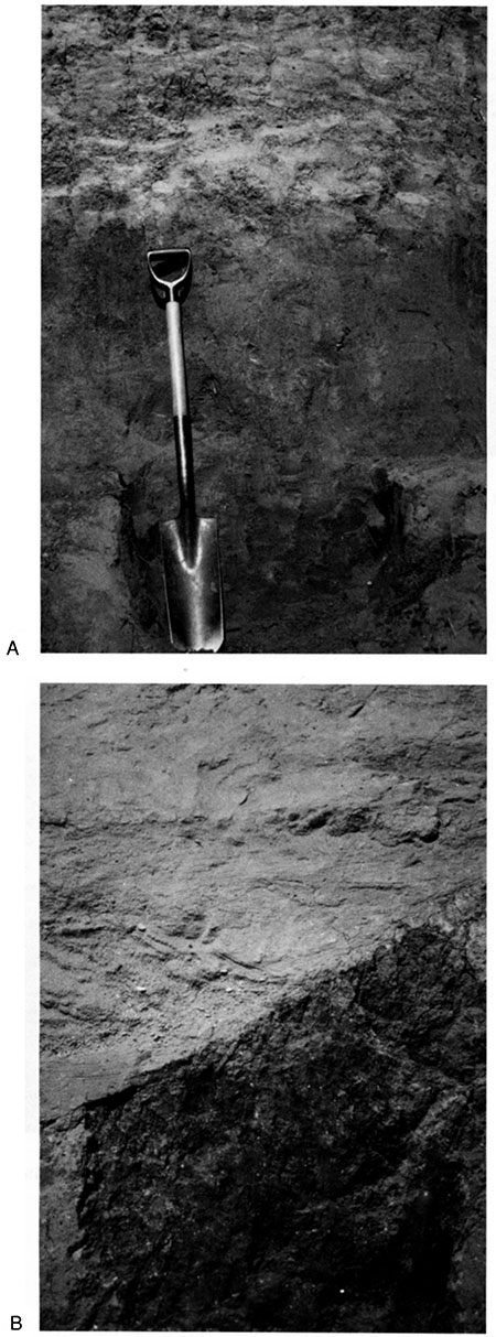
Buckner Creek has deeply incised its valley fill, creating many steep cutbanks throughout locality BC-1. A survey of cutbanks resulted in the discovery of site 14HO306 (fig. 52). Buckner Creek migrated into a remnant of the T-1 terrace at site 14HO306, creating a 7.2-m-high (24-ft-high) cutbank that reveals multiple buried paleosols and several prehistoric cultural horizons in the terrace fill (fig. 54). The section at site 14HO306 was selected for study because it appeared to be representative of T-1 fill examined in other sections along Buckner Creek and because it contained stratified archeological materials for radiometric and relative dating.
Figure 54--Section at site 14HO306 at locality BC-1. (A) The vehicle is on the T-1 surface. (B) Dark A horizons of the Buckner Creek (BC) and Hackberry Creek (HC) paleosols.
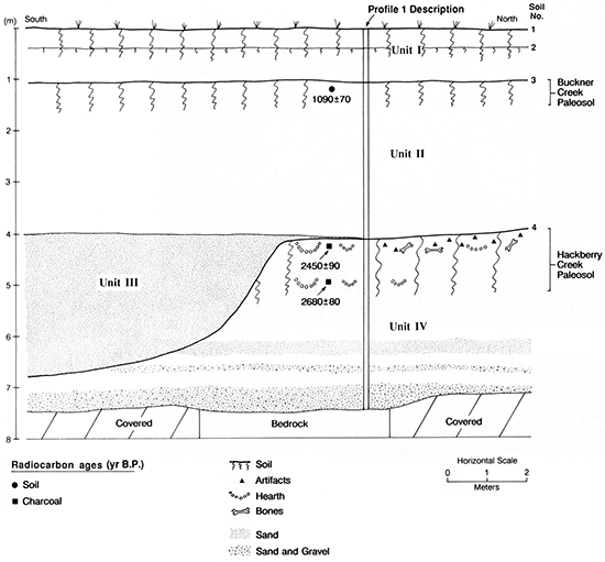
Three stratigraphic units and five buried paleosols were identified in the section at site 14HO306 (fig. 55). The lowest unit (unit III) is 3.18 m (10.4 ft) thick and consists of gravelly fine sand at its base grading upward to silt loam. A paleosol (soil 6) at the top of unit III has a thick, dark Ak horizon above a thin Bk horizon (see appendix table A.13). The 6Akb horizon (6Akb1 + 6Akb2) is 77 cm (2.5 ft) thick and is a dark-grayish-brown (10YR 4/2, dry) to grayish-brown (10YR 5/2, dry) silt loam. Carbonate morphology is weak in the 6Akb horizon (stage I). However, calcium carbonate content steadily increases with depth below the 6Ab1 horizon, reaching a maximum of 8.5% in the 6Ck horizon (table 3). The 6Bkb horizon is 52 cm (1.7 ft) thick and is a brown (10YR 5/3, dry) silt loam. Films and threads of calcium carbonate are common and there are a few small, hard carbonate concretions (stage II) in the 6Bkb horizon.
Figure 55--Cross-sectional diagram of section at site 14HO306 showing stratigraphic units, soils, prehistoric cultural horizons, and radiocarbon ages.
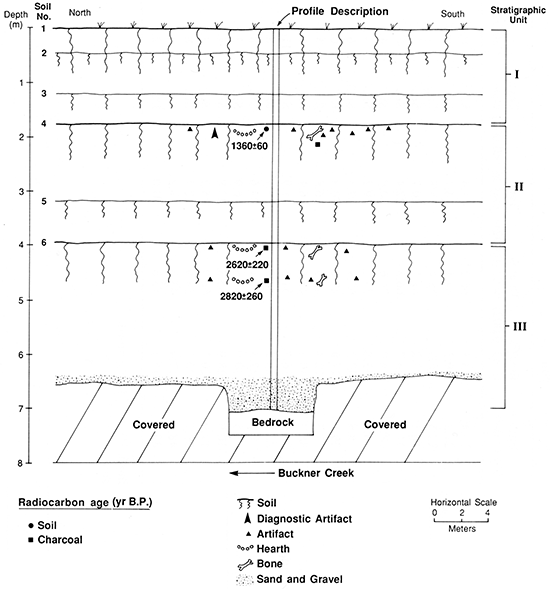
Table 3--Particle-size distribution and calcium carbonate content of sediment samples from section at site 14HO306
| Depth (cm) |
Soil horizon |
Particle-size distribution (mm) | ||||||||||||
|---|---|---|---|---|---|---|---|---|---|---|---|---|---|---|
| Sanda | Silt | |||||||||||||
| VC % (0.25-1.0) |
C % (0.10-0.5) |
M % (2.0-0.25) |
F % (0.02-0.10) |
VF % (0.05-0.05) |
Total % (2.0-0.05) |
Fine % (0.02-0.002) |
Total % (0.05-0.002) |
Total clay % (<0.002) |
Texture classb |
CaCO3 (%) | ||||
| 0-18 | Ap | 0.2 | 1.9 | 3.5 | 7.5 | 9.3 | 22.4 | 23.1 | 66.2 | 11.4 | SiL | 0.4 | ||
| 18-38 | A | 0.2 | 2.0 | 4.0 | 6.6 | 8.4 | 21.2 | 20.3 | 64.1 | 14.7 | SiL | 0.6 | ||
| 38-46 | AB | 0.2 | 0.7 | 2.1 | 8.4 | 11.1 | 22.5 | 16.5 | 58.7 | 18.8 | SiL | 7.2 | ||
| 46-61 | Bk1(2Ab) | 0.0 | 0.2 | 1.0 | 2.3 | 6.7 | 10.2 | 27.2 | 69.1 | 20.7 | SiL | 5.5 | ||
| 61-86 | Bk2 | 0.0 | 0.7 | 1.1 | 3.4 | 6.1 | 11.3 | 25.7 | 66.3 | 22.4 | SiL | 6.2 | ||
| 86-119 | BCk | 0.2 | 0.2 | 0.3 | 2.0 | 5.7 | 8.4 | 16.9 | 71.6 | 20.0 | SiL | 4.7 | ||
| 119-147 | 3Akb | 0.1 | 0.2 | 0.5 | 1.8 | 4.0 | 6.6 | 33.0 | 74.2 | 19.2 | SiL | 4.5 | ||
| 147-176 | 3ACkb | 0.0 | 0.1 | 0.5 | 2.3 | 5.9 | 8.8 | 32.2 | 63.9 | 27.3 | SiCL | 6.4 | ||
| 176-210 | 4Ab | 0.2 | 2.6 | 7.2 | 11.9 | 7.7 | 29.6 | 17.8 | 49.6 | 20.8 | L | 0.4 | ||
| 210-241 | 4Akb | 0.4 | 2.3 | 7.7 | 16.1 | 10.8 | 37.3 | 12.4 | 45.9 | 16.8 | SiL | 5.4 | ||
| 241-271 | 4ABkb | 0.3 | 1.9 | 7.4 | 17.1 | 11.6 | 38.3 | 10.3 | 45.6 | 16.1 | SiL | 9.5 | ||
| 271-317 | 4Bkb | 0.1 | 0.8 | 3.6 | 10.3 | 11.7 | 26.5 | 16.7 | 51.6 | 21.9 | SiL | 11.1 | ||
| 317-345 | 5Akb | 0.3 | 0.5 | 0.9 | 11.0 | 13.1 | 25.8 | 20.2 | 54.3 | 19.9 | SiL | 8.0 | ||
| 345-394 | 5Ckb | 0.4 | 1.2 | 1.4 | 1.3 | 5.0 | 9.3 | 27.3 | 66.1 | 24.6 | SiL | 8.6 | ||
| 394-432 | 6Ab1 | 0.4 | 0.7 | 1.2 | 2.7 | 3.5 | 8.5 | 30.9 | 64.6 | 26.9 | SiL | 3.8 | ||
| 432-471 | 6Ab2 | 0.4 | 1.0 | 2.1 | 3.4 | 4.0 | 10.9 | 28.9 | 65.3 | 23.8 | SiL | 4.7 | ||
| 471-523 | 6Bkb | 0.2 | 0.9 | 3.1 | 7.3 | 6.4 | 17.9 | 20.1 | 56.9 | 25.2 | SiL | 7.4 | ||
| 523-658 | 6BCkb | 0.2 | 1.7 | 4.5 | 8.4 | 5.9 | 20.7 | 20.7 | 56.9 | 22.4 | SiL | 8.5 | ||
| 658-685 | 6Cb1 | 0.3 | 1.9 | 3.2 | 22.3 | 20.4 | 48.1 | 17.9 | 45.7 | 6.2 | SL | 3.7 | ||
| 685-712 | 6Cb2 | 2.1 | 2.9 | 5.1 | 37.1 | 36.2 | 83.4 | 15.1 | 13.6 | 3.0 | LS | 2.3 | ||
| a. VC, very coarse grained; C, coarse-grained; M, medium-grained; F, fine-grained; VF, very fine grained. b. L, loam; SiL, silt loam; SiCL, silty clay loam; SL, sandy loam; LS, loamy sand. |
||||||||||||||
Cultural materials, including chert flakes, fire-cracked rocks, and burned bones were observed in the upper 15 cm (0.49 ft) and lower 10 cm (0.33 ft) of the 6Akb1 and 6Akb2 horizons, respectively (fig. 55). Although no culturally diagnostic artifacts were recovered from soil 6, charcoal from a hearth 5-10 cm (2-4 in.) beneath the surface of the 6Akb1 horizon yielded a radiocarbon age of 2,620 ± 220 yr B.P. In addition, a radiocarbon age of 2,820 ± 260 yr B.P. was determined on charcoal from a zone of fire-cracked rocks and burned bones 70-75 cm (2.3-2.5 ft) below the surface of the 6Akb1 horizon. The great thickness of soil 6 and the presence of two Late Archaic cultural levels in the 6Akb horizon suggest that soil formation was accompanied by slow aggradation between ca. 2,800 and 2,600 yr B.P. Hence soil 6 appears to be a "cumulative soil" (Nikiforoff, 1949).
Unit II is 2.18 m (7.15 ft) thick and is composed of calcareous loamy alluvium. Soils 5 and 4 are developed in the middle and at the top of unit II, respectively (fig. 55). Soil 5 has a thin, faint Ak-Ck profile that is difficult to trace across the exposure. Soil 4 is characterized by a thick, dark A horizon that clearly stands out in the section (fig. 54). The 4Akb horizon (4Ab + 4Akb) is 61 cm (2.0 ft) thick and has a silt loam texture. Carbonate content steadily increases with depth in soil 4, ranging from 0.4% in the 4Ab horizon to 11.1 % in the 4Bkb horizon (table 3). Carbonate morphology reflects this trend, increasing from stage I in the 4Akb horizon to stage II in the 4Bkb horizon. The 4Bkb horizon is 46 cm (1.5 ft) thick and is a brown (10YR 5/3) silt loam. Structural development is weak in the 4Bkb horizon, and there is little evidence of clay illuviation.
Several hearths and lithic artifacts and many burned and unburned bone fragments were observed in soil 4 (figs. 54 and 55). The artifact assemblage included a projectile point characteristic of the Keith variant of the Plains Woodland period. Radiocarbon assays from the High Plains place the Keith variant from ca. 1,600 to 1,200 yr B.P. (Grange, 1980, p. 126). A radiocarbon age of 1,360 ± 60 yr B.P. determined on humates from the upper 25 cm (0.82 ft) of soil 4 falls within this period.
Unit I, which is at the top of the section, is 1.76 m (5.77 ft) thick and is composed of calcareous fine-grained alluvium. Two paleosols (soils 2 and 3) with thin A horizons are developed in unit I (fig. 55). The Roxbury silt loam, which is developed at the top of unit I, has A-Bk-BCk horizonation. This surface soil is a Haplustoll and is welded into soil 2. Soil welding helps explain the dark zone within the upper 15 cm (0.49 ft) of the Roxbury Bk horizon (see appendix table A.13). The Bk horizon is 40 cm (1.3 ft) thick and is characterized by weak, fine, subangular-blocky structure. Carbonate morphology is weak, reaching a maximum of stage I+ in the Bk horizon.
With the exception of the Roxbury silt loam (soil 1), soils 4 and 6 are morphologically the best expressed soils in the section at site 14HO306. Two dark, over-thickened A horizons resembling soils 4 and 6 were observed in cutbank exposures of T-1 fill throughout Buckner Creek valley. Exposures of T-1 fill in many other small valleys in the Pawnee River basin also display two distinct A horizons among the buried soils. In an earlier study I suggested that soils 4 and 6 are stratigraphic markers and informally named them the Buckner Creek and Hackberry Creek paleosols, respectively (Mandel, 1988a). The cutbank exposure at site 14HO306 is designated in the present study as the type section for both of these paleosols.
Two cores were taken from T-1 fill near site 14HO306: core 1 on the east side of Buckner Creek and core 2 on the west side (fig. 52). The stratigraphy observed in these cores indicates that depositional units and buried soils exposed in the cutbank extend laterally away from the modern channel of Buckner Creek (fig. 56). The T-1 fill is inset against bedrock along the margin of the valley floor.
Figure 56--Cross-sectional diagram of Buckner Creek valley at locality BC-1.
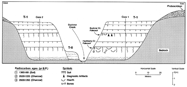
Exposures in gullies reveal that the erosion surfaces cut into bedrock immediately upslope from T-1 terraces are mantled by a thin veneer of well-rounded alluvial gravel (fig. 56). Much of the gravel is siliceous material derived from the Rocky Mountains and was transported across the High Plains by eastward-flowing streams during Tertiary and early Pleistocene times (Frye and Leonard, 1952). The veneer of gravel generally is less than 1.5 m (4.9 ft) thick at locality BC-1, and it has been altered by slope processes, especially gully and rill erosion. Although the absolute age of these coarse-grained deposits is unknown, concentrations of Proboscidean bones on and below their surfaces (fig. 56) suggest that the gravels accumulated during the Pleistocene.
Modern floodplain (T-0) deposits were examined in many cutbanks throughout locality BC-1. These deposits are inset against T-1 fill or bedrock. All sections of T-0 fill exhibit the following characteristics: (1) Bedding is preserved throughout the vertical extent of the fill, except where it has been modified by pedogenesis; (2) the lower portion of the fill is gravelly, whereas the upper portion is loamy; and (3) soils with thin A-C profiles are developed at the top of the fill.
No cultural deposits were detected in the T-0 fill. However, portions of an articulated bison skeleton were found eroding out of T-0 deposits at a cutbank locality (site 14HO315), 2.8 km (1.7 mi) upstream from site 14HO306 (fig. 57). The section at site 14HO315 is described in appendix table A.14. Bison bones were collected for radiocarbon dating.
Figure 57--Site 14HO315 at locality BC-1. (A) Cutbank exposure of T-0 fill with uplands in the background. (B) Close-up of the cutbank showing bison bones in a buried A horizon. Note the bedding above the buried soil.
Two stratigraphic units and one buried paleosol were identified in the section at site 14HO306. The lower unit (unit II) is 3.02 m (9.91 ft) thick and is composed of stratified, well-sorted gravels that grade upward to loamy alluvium. A paleosol (soil 2) with Ak-ACk-C horizonation is developed at the top of unit II. The 2Akb horizon is 46 cm (1.5 ft) thick and is a grayish-brown (10YR 5/2) silt loam. Approximately 95% of the gravel in the 2C horizon consists of limestone pebbles, with siliceous rocks composing the rest. The upper 2.3 m (7.5 ft) of the T-0 fill consists of loamy alluvium, and bedding is preserved near the top of this fill (fig. 57B).
The bison skeleton was discovered in the 2ACkb horizon at a depth of 1.10-1.30 m (3.61-4.27 ft) below the T-0 surface (fig. 57B). A tibia, calcaneus, and malleolus were combined and sent to the University of Texas Radiocarbon Laboratory. These bones collectively yielded a radiocarbon age of 1,010 ± 410 yr B.P. (apatite). This represents the only numerical age from T-0 fill in the Pawnee River basin.
Unit 1 of the T-0 fill is 59 cm (1.9 ft) thick and is composed of calcareous vertical accretion deposits. A Haplustoll with a thin A-C profile is developed in fine-grained, stratified alluvium at the top of unit I (fig. 57B). Organic matter has darkened only the upper 30 cm (0.98 ft) of this surface soil, and there is minimal structural development in the A horizon. Altogether, the morphology of this soil and that of other soils developed at the top of T-0 fill in Buckner Creek valley suggest that the floodplain surfaces are young.
Radiocarbon assays combined with archeological evidence indicate that the bulk of the alluvium stored in the valley bottom of Buckner Creek accumulated during the late Holocene. Specifically, most of the T-1 fill aggraded between ca. 2,800 and 1,360 yr B.P. Aggradation of T-1 fill was punctuated by episodes of floodplain stability and concomitant soil development. Although some of these episodes of stability were relatively short, as indicated by thin, faint A-C profiles among the buried soils developed in T-1 fill, two episodes were longer. These two episodes are represented by the thick, dark Hackberry Creek and Buckner Creek paleosols. Development of the Hackberry Creek paleosol was underway by at least ca. 2,800 yr B.P. and continued to at least ca. 2,600 yr B.P. The Buckner Creek paleosol was forming by at least ca. 1,360 yr B.P., although bounding dates for development of this soil are not available at locality BC-1.
Buckner Creek downcut sometime after ca. 1,360 yr B.P., leaving its late Holocene floodplain as the T-1 terrace. Because the T-1 surface was isolated from frequent floods, a Mollisol with A-Bw horizonation developed at the top of the T-1 fill.
Based on the radiocarbon age of bison bones recovered from the T-0 fill at site 14HO315, the modern floodplain was aggrading by at least ca. 1,000 yr B.P. Weak soil development at the top of the T-0 fill suggests that the floodplain surface is very young, probably postdating Euro-American settlement in the region (ca. A.D. 1830). The absence of prehistoric archeological sites on T-0 surfaces at locality BC-1 and other reaches of Buckner Creek valley supports this hypothesis.
Locality HC-1
Locality HC-1 is situated in Hackberry Creek valley, 9.5 km (5.9 mi) upstream from the confluence of that creek with the Pawnee River (fig. 16). Hackberry Creek is a fourth-order stream and has a gradient of 2.05 m/km (11 ft/mi) at this locality. The valley trends east-west and is asymmetric, with steep north-facing slopes and gentle south-facing slopes. The valley floor is about 2 km (1.2 mi) wide and is composed of a floodplain complex (T-0a and T-0b) and a low, broad terrace (T-1) (fig. 58). The lowest floodplain surface (T-0a) is 20-30 m (66-98 ft) wide and is separated from the next highest surface (T-0b) by a 1.8-m-high (5.9-ft-high) scarp. The T-0b surface is 30-50 m (98-164 ft) wide and is separated from the T-1 surface by a prominent 4-m-high (13-ft-high) scarp. T-1 is a paired terrace, and its broad, flat surface dominates the valley floor.
Hackberry Creek has migrated laterally across its valley floor, cutting into the T-1 fill at site 14NS308 (fig. 58). As a result, the creek has created a 7.5-m-high (25-ft-high) cutbank (fig. 59) that exposes a thick section of alluvium beneath the T-1 surface. Charcoal, bone, fire-cracked rocks, and chert flakes were detected in a deeply buried paleosol within the section at site 14NS308. Hence this site was selected for detailed subsurface investigation to obtain temporal data along with alluvial stratigraphic information. The section is described in appendix table A.15; soil and charcoal samples were collected for radiocarbon dating.
Figure 58--Landform map of locality HC-1 showing location of site 14NS308.
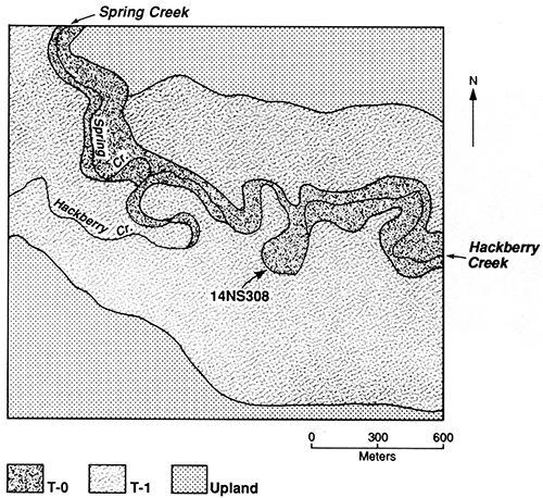
Figure 59--Section at site 14NS308 at locality HC-1. (A) The vehicle is on the T-1 surface. (B) Flags mark prehistoric cultural material in the Hackberry Creek paleosol.
Four stratigraphic units and three buried paleosols were identified in the section at site 14NS308 (fig. 60). The lowest stratigraphic unit (unit IV) is 3.40 m (11.2 ft) thick. Gravelly, sandy, and coarse-loamy fluvial deposits compose the lower half of unit IV, and the upper half consists of fine-grained alluvium. Stratified sand and gravel at the base of unit IV overlies bedrock (fig. 60). This stratified alluvium is calcareous and contains many gastropods and pelecypods. Loamy alluvium above the stratified fill grades upward into silty alluvium at the top of unit IV. The loamy and silty alluvium is calcareous and contains a rich assemblage of gastropods.
Figure 60--Cross-sectional diagram of section at site 14NS308 showing stratigraphic units, soils, prehistoric cultural horizons, and radiocarbon ages.
Soil 4 at the top of unit IV (fig. 60) has an Ak-Bk profile. The 4Akb horizon is 1.10 m (3.61 ft) thick and is a brown (10YR 5/3, dry) silt loam (fig. 6IA). Carbonate morphology is weak (stage I+) in the 4Akb and 4Bkb horizons and is slightly better developed (stage II) in the 4Ck1 and 4Ck2 horizons.
Prehistoric cultural materials, including chert flakes and a biface, were observed in the A horizon of soil 4 at site 14NS308 (fig. 60). None of this material, however, was diagnostic of a cultural period. Soil 4 also contains hearths and many bones and bone fragments. A small volume of charcoal [3.0 g (0.0066 lb)] recovered from the surface of the 4Akb1 horizon yielded a radiocarbon age of 2,340 ± 400 yr B.P. Charcoal from a hearth 5-15 cm (2-6 in.) beneath the surface of the 4Akb horizon produced a radiocarbon age of 2,450 ± 90 yr B.P. A third radiocarbon age, 2,680 ± 80 yr B.P., was determined on charcoal from a cultural level 80-100 cm (2.6-3.3 ft) beneath the surface of the 4Akb horizon.
The presence of an over-thickened A horizon (soil 4) containing two Late Archaic cultural levels indicates that deposition of alluvium was accompanied by soil formation on the late Holocene floodplain (now the T-1 terrace) of Hackberry Creek. The uniform color and texture of the cumulic A horizon suggests that deposition was gradual and may have occurred without major interruptions from ca. 2,700 to 2,300 yr B.P. Based on its morphological characteristics and the radiocarbon ages, soil 4 is correlated with the Hackberry Creek paleosol at site 14HO306 (type section) in Buckner Creek valley.
At the southern end of the exposure, soil 4 and the underlying alluvium have been deeply incised by a channel (fig. 60). This channel is filled with crossbedded sands containing many gastropods (fig. 61 B). The channel fill (unit III) and the Hackberry Creek paleosol are mantled by massive silts composing unit II.
Figure 61--(A) Hackberry Creek paleosol exposed in section at site 14NS308. Note the thickness of the A horizon. (B) Eroded surface of the Hackberry Creek paleosol where it has been incised by a former channel of Hackberry Creek. Note the crossbedding in the channel fill.
Unit II is 3.08 m (10.1 ft) thick and is composed of calcareous silt loam. A distinct paleosol (soil 3) with AAB-Bk-Ck horizonation is developed at the top of this alluvial unit. The 3Ab horizon is 44 cm (1.4 ft) thick and dark grayish brown (10YR 4/2, dry). The 3Bkb horizon is 32 cm (1.0 ft) thick and is a pale-brown (10YR 6/3, dry) silt loam with stage I+ carbonate morphology. A radiocarbon age of 1,090 ± 70 yr B.P. was determined on humates from the upper 30 cm (0.98 ft) of the 3Ab horizon.
The upper unit (unit I) is 1.07 m (3.51 ft) thick and is composed of fine-loamy alluvium. The modern surface soil (soil 1) is developed at the top of unit 1. This soil is classified as the Roxbury silt loam, a Haplustoll with a thick noncalcareous A horizon above a calcareous Bk horizon. The Bk horizon has light silty clay loam texture, weak subangular-blocky structure, and stage I carbonate morphology.
The Roxbury profile at site 14HO308 represents complex soil development. Based on soil color, the Bk horizon appears to be welded into the A horizon of a buried soil (soil 2) 55-67 cm (1.8-2.2 ft) below the T-1 surface. Despite its relatively shallow depth, organic matter in the A horizon of soil 2 has not been completely oxidized during the course of modern pedogenesis.
The sequence of buried soils exposed in a second section (profile 2) about 50 m (160 ft) downstream from site 14NS308 is similar to profile I (fig. 62). However, no cultural materials were detected in profile 2. Absence of these materials provided an opportunity to recover soil samples from soil 4 that were uncontaminated by prehistoric cultural carbon. Radiocarbon ages of 1,950 ± 50 and 2,170 ± 50 yr B.P. were determined on humates from the upper 20 cm (0.66 ft) of the 4Akb1 and 4Akb2 horizons, respectively. The mean residence time for organic carbon and the radiocarbon ages determined on charcoal from the 4Ab1 and 4Ab2 horizons in profile 1 indicate that development of soil 4 was underway by at least ca. 2,700 yr B.P. and continued to as late as ca. 1,950 yr B.P.
Figure 62--Profile 2 located about 50 m downstream from site 14NS308. Note the bison bone above and to the right of the shovel.
Although profile 2 contained no archeological materials, the skeletal remains of a bison were discovered in the AC horizon of soil 3 (fig. 62). Collagen and apatite from a composite sample (femur + pelvis) yielded radiocarbon ages of 1,190 ± 370 and 1,310 ± 130 yr B.P., respectively. These ages slightly predate the radiocarbon age of 1,090 ± 70 yr B.P. determined on humates from the A horizon of soil 3 in profile 1.
Based on the assemblage of radiocarbon ages from site 14HO308, the bulk of the alluvium composing T-1 fill at locality HC-1 was deposited between ca. 2,700 and 1,000 yr B.P. Accumulation of alluvium on the late Holocene floodplain (now the T-1 terrace) occurred primarily through vertical accretion. However, lateral-accretion deposits compose the lower 1.5 m (4.9 ft) of the T-1 fill. Pedogenesis accompanied slow aggradation from ca. 2,680 to 2,450 yr B.P., resulting in the development of a cumulic soil (Hackberry Creek paleosol) with an over-thickened A horizon. Mean residence time for organic carbon from the upper 20 cm (0.66 ft) of the Hackberry Creek paleosol indicates that it was still developing as late as ca. 2,000 yr B.P. Sometime after that, a channel was cut into this late Holocene paleosol. The channel was subsequently filled, and renewed alluviation resulted in burial of the Hackberry Creek paleosol. A major portion of the T-1 fill (unit II) aggraded between ca. 2,000 and 1,000 yr B.P. A second major episode of landscape stability is indicated by the Buckner Creek paleosol (soil 3), which developed at the top of unit II. Radiocarbon assays indicate that this soil developed between ca. 1,190 and 1,000 yr B.P. A final episode of T-1 aggradation occurred sometime after ca. 1,000 yr B.P. This period of alluviation resulted in burial of the Buckner Creek paleosol. Deep incision and subsequent accumulation of T-0 fill also occurred sometime after 1,000 yr B.P. However, the exact timing of these last two events is unknown.
Locality HC-2
Locality HC-2 is situated in Hackberry Creek valley, approximately 2 km (1.2 mi) upstream from the confluence of that creek with the Pawnee River (fig. 16). Hackberry Creek is a fourth-order stream and has a gradient of 1.50 m/km (7.9 ft/mi) at this locality. The valley floor is 0.8 km (0.5 mi) wide and is bordered by moderately sloping valley walls. Three landforms compose the valley bottom: a narrow floodplain (T-0), a low terrace (T-1), and an intermediate terrace (T-2) (fig. 63). The T-0 surface is 50-250 m (164-820 ft) wide and is separated from the adjacent T-1 surface by a prominent 4-m-high (13-ft-high) scarp. Although broad paired surfaces of the T-1 terrace dominate the valley bottom at locality HC-2, there is an extensive remnant of a second terrace (T-2) on the west side of the stream (figs. 63 and 64). This remnant is one of the few occurrences of the T-2 terrace in the lower Hackberry Creek valley; no traces of a T-2 terrace were documented in the middle or upper reaches of Hackberry Creek. The soil-stratigraphic investigations at locality HC-2 focused on deposits underlying the T-2 surface.
Figure 63--Landform map of locality HC-2 showing location of site 14HO316.
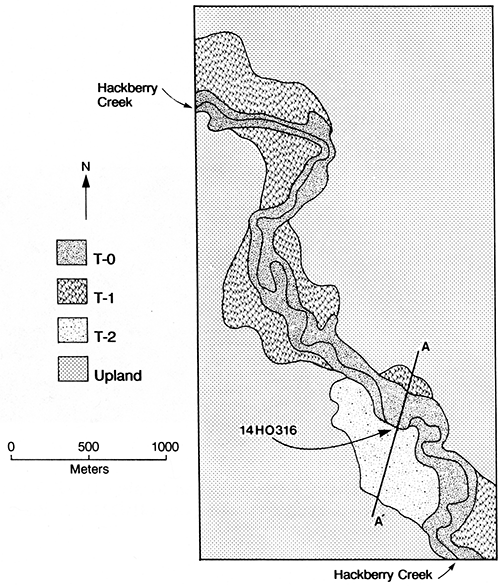
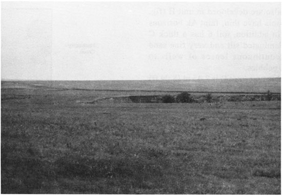
Figure 64--Hackberry Creek valley at locality HC-2. The T-2 surface is immediately above the cutbank exposure (site 14HO316) in the center of the photo.
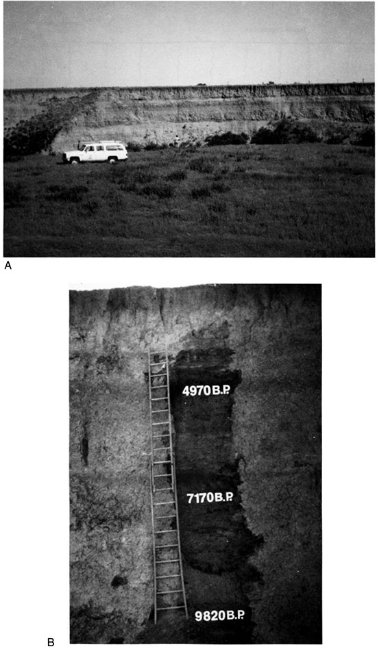
Hackberry Creek has migrated laterally across its valley floor, cutting into the T-2 fill at a place designated as site 14HO316 (fig. 63). An 8-m-high (26-ft-high) cutbank at site 14HO316 (fig. 65) exposes a thick section of valley fill beneath the T-2 surface. Coring revealed that bedrock is less than 1 m (0.3 ft) below the base of the cutbank. The complex stratigraphy observed in this cutbank is described in appendix table A.16. Three soil samples were collected for radiocarbon dating.
Figure 65--Section at site 14HO316. (A) The vehicle is on the T-0 surface. (B) The distance between each rung of the ladder is 30 cm.
Four stratigraphic units and eight buried paleosols were identified in the section at site 14HO316 (fig. 66). The lowest unit (unit IV) consists of stratified sand and gravel overlying bedrock. These coarse-grained lateral-accretion deposits grade upward into fine-grained vertical-accretion deposits. A paleosol (soil 9) with Ak-ACk-C horizonation is developed at the top of unit IV. The 9Ak horizon is 20 cm (0.66 ft) thick and is a brown (10YR 4/3, dry) silt loam. Carbonate morphology is weak (stage I) in soil 9, although there are a few large, hard concretions scattered through the silty matrix.
Figure 66--Cross-sectional diagram of section at site 14HO316 showing stratigraphic units, soils, and radiocarbon ages.
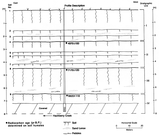
Unit III is composed of fine-grained alluvium with a few discontinuous lenses of small rounded pebbles near its base. A distinct paleosol (soil 8) with Ak-Bk-BCk horizonation is developed at the top of unit III. Soil 8 is the thickest and most strongly developed paleosol in the section. The 8Akb horizon is 40 cm (1.3 ft) thick and is a brown (1OYR 3/3, dry) silt loam. There are common films and threads and a few fine, hard concretions of calcium carbonate (stage I+) in the 8Akb horizon. The 8Bkb horizon is 45 cm (1.5 ft) thick and is a brown (10YR 3/3, dry) silty clay loam. There is weak, fine, subangular-blocky structure in the 8Bkb horizon, and carbonate morphology is the same as that in the 8Akb horizon. The underlying Ck horizon consists of brown (1OYR 5/3, dry) calcareous loam with massive structure and few thin, discontinuous lenses of well- to subrounded limestone and chert pebbles.
Unit II is 2.06 m (6.76 ft) thick and is largely composed of fine-grained alluvium. Soil 4, which is developed at the top of unit II (fig. 66), has a dark-grayish-brown (10YR 4/2, dry) silt loam A horizon above a brown (1OYR 5/4, dry) loam ACk horizon. The 4Akb horizon is 36 cm (1.2 ft) thick and has stage I carbonate morphology. Soils 5, 6, and 7 also are developed in unit II (fig. 66). These three paleosols have thin, faint Ak horizons above ACk horizons. In addition, soil 6 has a thick C horizon composed of laminated silt and very fine sand with a few thin, discontinuous lenses of well- to subrounded calcareous pebbles.
The upper stratigraphic unit (unit I) is 2.45 m (8.04 ft) thick and is composed of fine-grained alluvium. The modern surface soil (soil 1) at the top of unit I is the Hord silty clay loam, a Pachic Haplustoll with a thick, noncalcareous silt loam A horizon above a light silty clay loam Bw horizon. A few films and threads of calcium carbonate (stage I) are present in the underlying Bk horizon and extend down into the BCk horizon. The C horizon is composed of pale-brown (10YR 6/3, dry) silt loam with massive structure and a few thin, discontinuous lenses of very fine sand.
Two buried paleosols (soils 2 and 3) are developed in the lower 90 cm (3.0 ft) of unit 1. Both of these paleosols have thin Ak-ACk profiles with weak (stage I) carbonate morphology. The 2Akb and 3Akb horizons are dark-grayish-brown (10YR 5/2, dry) silty clay loams. Sediment composing the 2ACkb and 3ACkb horizons is predominantly silt loam, but there are many thin lenses of very fine sand.
Three radiocarbon ages were determined on soil humates from site 14HO316, one from each of the major paleosols developed in the T-2 fill. Humates from the upper 20 cm (0.66 ft) of soils 4, 8, and 9 yielded ages of 4,970 ± 100,7,170 ± 120, and 9,820 ± 110 yr B.P., respectively. These ages and the soil-stratigraphic evidence indicate that the bulk of the sediment composing the T-2 fill at site 14HO316 accumulated during the early and middle Holocene.
Although particle-size analyses were not conducted on sediments from site 14HO316, field observations detected a repetitive sequence of deposits beneath the T-2 surface. The deposits generally fine upward from the surface of one paleosol to the top of the next overlying paleosol. It is likely that this sedimentation pattern resulted from episodes of flooding and overbank deposition in Hackberry Creek valley. Runoff and erosion in the tributary basin upstream from Site 14HO316 contributed sediment to floodwaters in the lower reach of the valley. Unstable periods, marked by deposition of floodplain sediments, were followed by periods of stability and soil formation.
Based on the paleosol record, aggradation was interrupted by eight soil-forming intervals before the T-2 surface finally stabilized. However, only soils 1 and 8 have B horizons; the other paleosols have thin A-C profiles that are products of relatively short episodes of landscape stability.
The modern soil at the top of unit I developed when sedimentation ceased on the T-2 surface. Although the exact time of this event is unknown, it occurred sometime after 4,970 ± 100 yr B.P., which is the radiocarbon age determined on organic carbon from soil 4. Radiocarbon ages from T-1 fill in Hackberry Creek indicate that alluviation was underway again by ca. 2,700 yr B.P. Hence the episode of stream incision that left the middle Holocene floodplain as a stable terrace surface (T-2) occurred sometime between ca. 5,000 and 2,700 yr B.P.
Six cores were taken along a cross-valley transect (A-A', fig. 67) to determine whether different terrace levels might be surfaces cut on T-2 fill (i.e., fillstrath terraces). Also, two of the cores provided information about the lateral extent, depth, and thickness of deposits and buried paleosols beneath the T-2 surface at site 14HO316.
Figure 67--Cross-sectional diagram of Hackberry Creek valley at locality HC-2.
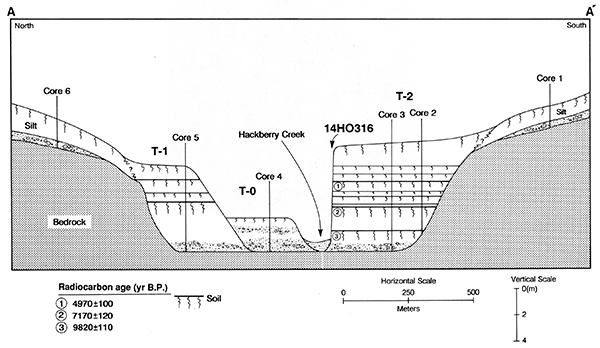
Cores 2 and 3 were taken from T-2 fill near the valley wall and at the midsection of the T-2 terrace, respectively (fig. 67). The soil-stratigraphic sequences observed in these cores indicate that deposits and buried soils exposed in cutbank 14HO316 continue laterally toward the valley wall in a horizontal fashion beneath the T-2 surface. No variability in thickness, physical properties, or depth of paleosols was detected. Hence early and middle Holocene floodplain surfaces represented by buried paleosols in T-2 fill appear to have been relatively flat.
Based on subsurface information gleaned from core 1 (fig. 67) and gully exposures, the T-2 fill is inset against limestone bedrock. The bedrock is mantled by a thin veneer of limestone gravel, and a 1.5-2.0-m-thick (4.9-6.6-ft-thick) unit of grayish-brown silt overlies the gravel. Although the grayish-brown silt often is referred to as Peoria loess [e.g., Haberman et al. (1973)], it may be colluvium (i.e., reworked loess), given that it occurs at the base of a slope and contains a few pebbles. The stratigraphic relationship of the silty slope deposits to the T-2 surface deposits has not been determined.
Core 5, taken from T-1 fill on the north side of Hackberry Creek (fig. 67), revealed a sequence of deposits and buried paleosols similar to the one observed beneath the T-1 surface at localities HC-1 and BC-1. Two buried soils with thick, dark A horizons are developed in fine-loamy alluvial deposits. A thin, faint paleosol with A-C horizonation is developed in the alluvium between these soils. The uppermost and lowermost buried soils are morphologically similar to the Buckner Creek and Hackberry Creek paleosols, respectively. The soil-stratigraphic sequence observed in core 5 is visible in cutbank exposures of T-1 fill throughout locality HC-2 and along other reaches of Hackberry Creek. At several of these exposures T-1 fill was seen abutting the bedrock valley wall, as shown in fig. 67.
Core 6, taken on sloping uplands adjacent to T-1 (fig. 67), revealed a soil-stratigraphic sequence identical to the one observed in core 1 on the south side of the creek. A 2-m-thick (7-ft-thick) deposit of silty sediment overlies a thin layer of limestone and chert gravel above bedrock.
Modern floodplain (T-0) deposits are inset against T-1 fill on the north side of Hackberry Creek (fig. 67). Core 4 revealed a 1-m-thick (3-ft-thick) cap of fine-textured alluvium above alternating beds of sandy loam, sand, and gravel. The T-0 deposits at this locality are distinct from T-1 and T-2 deposits in that the T-1 material is coarser and much more stratified and does not contain buried paleosols. Also, the T-0 fill is largely composed of lateral-accretion deposits whereas the bulk of T-1 and T-2 alluvium consists of vertical-accretion deposits. Stratigraphic information gleaned from core 5 indicates that beds of sand and gravel below the T-0 surface do not continue beneath the T-1 surface. Hence the T-0 surface does not represent a surface cut into T-1 fill. The presence of an Entisol with a thin A horizon at the top of the T-0 fill indicates that the floodplain surface has not been stable for a long period of time. Altogether, the soil-stratigraphic evidence suggests that alluvium composing the T-0 fill rapidly accumulated and that the modern floodplain is still aggrading.
Locality SC-1
Locality SC-1 is situated in Sawlog Creek valley, approximately 43 km (27 mi) upstream from the confluence of that creek with Buckner Creek (fig. 16). Sawlog Creek is a third-order stream and has a gradient of 2.9 m/km (15 ft/mi) at this locality. The valley trends east-west and is asymmetric, with moderately steep north-facing slopes and gentle south-facing slopes. The valley floor is 200-400 m (650-1,300 ft) wide and is composed of two landforms: a narrow modern floodplain (T-0) and a broad, low terrace (T-1). The T-0 surface is 20-30 m (66-98 ft) wide and is separated from the adjacent T-1 surface by a 3-m-high (10-ft-high) scarp. T-1 dominates the valley bottom and is a paired surface throughout locality SC-1 (fig. 68).
Figure 68--Landform map of locality SC-1 showing location of site 14FD311.
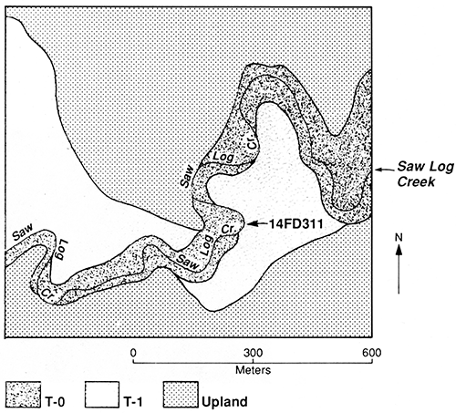
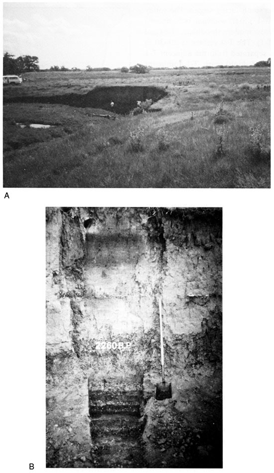
Lateral migration of Sawlog Creek has created a number of steep cutbanks that expose T-1 fill. One of these cutbanks (site 14FD3ll) was selected for detailed study at locality SC-1 (figs. 68 and 69). The T-1 fill is 3.65 m (12.0 ft) thick at site l4FD311 and has been described from the terrace surface down to its contact with bedrock (see appendix table A.17). Also, a soil sample was collected from the deepest buried paleosol for radiocarbon dating.
Figure 69--Section at site l4FD311 at locality SC-1. (A) The cutbank exposes fill beneath the T-1 surface. (B) Close-up of the section showing the buried paleosols. Radiocarbon age determined on humates from soilS. Note the bedding in the lower portion of the section.
Three stratigraphic units and four buried soils were identified at site 14FD311 (fig. 70). The lowest stratigraphic unit (unit III) is 1.65 m (5.41 ft) thick and overlies limestone. Unit III is largely composed of loamy alluvium. However, the lower portion of the unit consists of alternating beds of gravelly loam and organic-rich silty clay. Individual beds within the lower 95 cm (3.1 ft) of unit III are 5-35 cm (0.2-1.1 ft) thick and have smooth, abrupt boundaries (fig. 69B). Pelecypods are common in this stratified fill, indicating that it was deposited in a channel environment. Fine-loamy alluvium, composing the upper 70 cm (2.3 ft) of unit III, however, is characteristic of vertical-accretion deposits. The surface of unit III gently slopes from east to west (fig. 70).
Figure 70--Cross-sectional diagram of section at site 14FD311 showing stratigraphic units, soils, and radiocarbon ages.
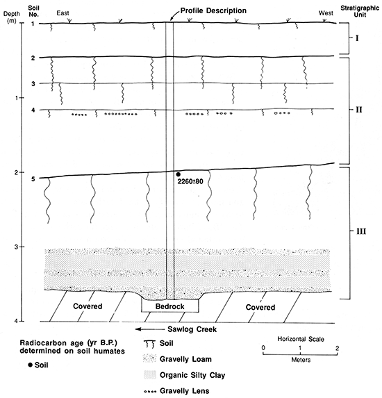
A distinct paleosol (soilS) with Ak-ACk horizonation is developed at the top of unit III (figs. 69 and 70). The 5Akb horizon is 64 cm (2.1 ft) thick and is a dark-grayish-brown (10YR 4/2, dry) silt loam. Carbonate morphology increases from stage I in the 5Akb horizon to stage I+ in the ACk horizon. Humates from the upper 20 cm (0.66 ft) of the 5Ab horizon yielded a radiocarbon age of 2,260 ± 80 yr B.P.
Unit II is 1.55 m (5.09 ft) thick and consists of loamy alluvium with a few thin lenses of gravel. Faint bedding is visible in the loamy fill, except where deposits have been modified by pedogenesis. Three paleosols (soils 2, 3, and 4) are developed in unit II (fig. 70). All these soils have thin A-AC profiles, and soils 2 and 3 nearly merge to form a composite profile (figs. 69B and 70).
Unit I at the top of the section (fig. 70) is 45 cm (1.5 ft) thick and is composed of loam in its lower portion, grading upward to silt loam. The modern surface soil (soil 1) at the top of unit I is a Haplustoll with a thin A-C profile.
Based on the radiocarbon age of humates from soilS, the bulk of the sediment composing T-1 fill at locality SC-1 was deposited sometime after ca. 2,260 yr B.P. With the exception of coarse-grained lateral-accretion deposits within the lower meter of the fill, most of the alluvium accumulated through vertical accretion. The paleosol record indicates that T-1 aggradation was interrupted by at least three episodes of landscape stability and concomitant soil formation after ca. 2,260 yr B.P. However, the thin A-C profiles of soils 2, 3, and 4 suggest that these episodes were relatively short. Also, the presence of a weakly developed soil at the top of the T-1 fill suggests that the terrace surface is young.
The over-thickened A horizon of soil 5 strongly resembles the Hackberry Creek paleosol at sites 14HO306 and 14NS308. Also, the radiocarbon age of 2,260 ± 80 yr B.P. determined on humates from the upper 20 cm (0.66 ft) of the 5Akb horizon is close to the ages (1,950 ± 50 and 2,170 ± 50 yr B.P.) determined on humates from the Hackberry Creek paleosol at site 14NS308. Hence soil 5 may correlate with the Hackberry Creek paleosol.
Locality PR-11
Locality PR-11 is situated in the valley of an unnamed third-order tributary in the headwater area of the Pawnee River basin (fig. 16). The valley trends north-south, and its floor is about 75 m (250 ft) wide. The stream's gradient is 1.5 m/km (7.9 ft/mi), and there is about 50 m (160 ft) of relief at this locality.
The valley floor of the stream is composed of two landforms: a narrow modern floodplain (T-0) and a low terrace (T-1). The floodplain surface is 15-20 m (66-98 ft) wide and is separated from that of the T-1 terrace by a 3-m-high (10-ft-high) scarp. T-1 is a paired terrace, and its surface dominates the valley floor (fig. 71).
Figure 71--Landform map of locality PR-11.
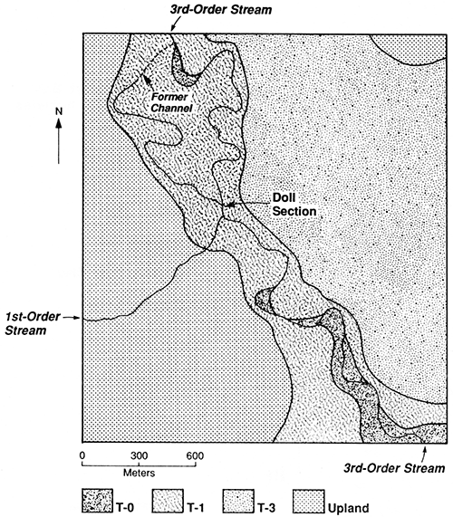
The stream has migrated laterally into the T-1 fill at several places at locality PR-11, creating several cutbank exposures. One of these exposures, referred to as the Doll section (figs. 71 and 72), was selected for study. The section is described in appendix table A.18. Two soil samples were collected for radiocarbon dating.
Figure 72--Doll section at locality PR-11. (A) Channel of an unnamed third-order stream at the base of the cutbank. (B) Dark A horizons of soils 2 and 3. Radiocarbon ages determined on humates.
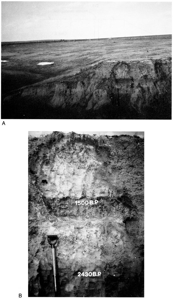
Three stratigraphic units and two buried paleosols were identified beneath the T-1 surface at the Doll section (fig. 73). The lowest unit (unit III) is at least 72 cm (2.4 ft) thick and is composed of fine-grained alluvium. A paleosol (soil 3) with a dark over-thickened Ak horizon above a Bk horizon is developed at the top of this unit (fig. 72B). The 3Akb horizon is 61 cm (2.0 ft) thick and is a brown (10YR 3/3) silt loam. Few films and threads of calcium carbonate (stage I) are present in the 3Akb horizon, but they become better developed and more common with increasing depth. The 3Bkb horizon is a brown (10YR 5/3, dry) silt loam with weak fine subangular-blocky structure. Films, threads, and fine soft masses of calcium carbonate (stage I+) are common in the 3Bk horizon.
Figure 73--Cross-sectional diagram of the Doll section at locality PR-11 showing stratigraphic units, soils, and radiocarbon ages.
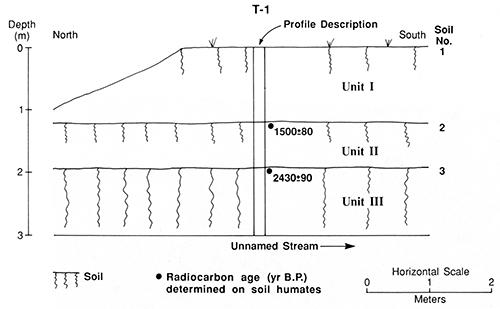
Unit II is 73 cm (2.4 ft) thick and is composed of calcareous silty alluvium. A paleosol (soil 2) with Ak-Ck horizonation is developed at the top of this unit. The 2Akb horizon is 21 cm (0.69 ft) thick and is a brown (10YR 4/3, dry) silt loam. Carbonate morphology is weak (stage I) throughout soil 2.
The upper unit (unit I) is 120 cm (3.94 ft) thick and is composed of calcareous fine-grained alluvium. The modern surface soil (soil 1) at the top of unit I is a Haplustoll with A-Bw-C horizonation. The A horizon is 26 cm (0.85 ft) thick and is a brown (10YR 5/3, dry) silt loam. Alluvium composing this unit becomes coarser with increasing depth below the A horizon, changing from a loam in the Bw horizon to a fine sandy loam in the C horizon. No secondary carbonates were detected in unit I.
Radiocarbon ages of 1,500 ± 80 and 2,430 ± 90 yr B.P. were determined on humates from the upper 15 cm (0.49 ft) of soils 2 and 3, respectively. These ages are similar to ones determined on materials from the Buckner Creek and Hackberry Creek paleosols, respectively. Based on the radiocarbon assays, unit III aggraded sometime before ca. 2,400 yr B.P. Accumulation of sediment composing unit II occurred after ca. 2,400 yr B.P. but before ca. 1,500 yr B.P. The final episode of T-1 aggradation took place sometime after ca. 1,500 yr B.P.
Locality PR-12
Locality PR-12 is situated in the headwater area of the Pawnee River basin (fig. 16). The Pawnee River is a third-order stream with a gradient of 1.3 m/km (6.9 ft/mi) at this locality. The valley floor is 1.1 km (0.68 mi) wide and is composed of two landforms: a modern floodplain (T-0) and a high terrace (T-3). Lateral erosion by the Pawnee River has apparently removed the T-1 and T-2 fills in this segment of the valley. The floodplain surface ranges from 30 m to 100 m (98-330 ft) in width and is separated from that of the T-3 terrace by a 7-m-high (23-ft-high) scarp. T-3 is a paired terrace, and its broad, gently sloping surface dominates the valley floor (fig. 74).
Figure 74--Landform map of locality PR-12 showing location of the Doll silo.
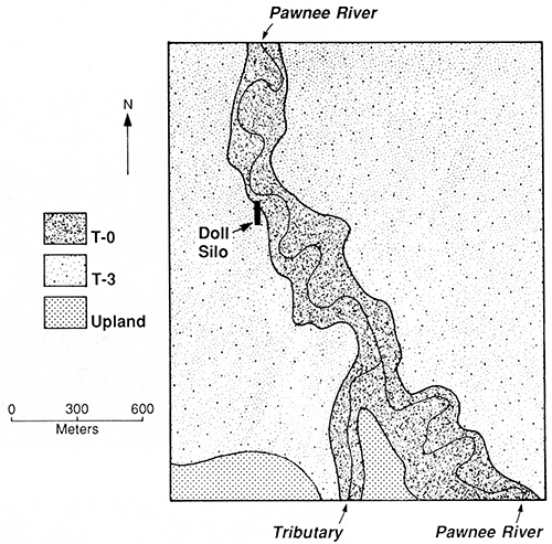
Although no cutbank exposures were found at locality PR-12, a trench silo provided an opportunity to examine a thick section of T-3 fill (figs. 74 and 75). The trench, which is referred to as the Doll silo, had been excavated into the scarp separating the T-0 surface from the T-3 surface. The soil stratigraphy exposed in the west wall of the trench is described in appendix table A.19 and is illustrated in fig. 76.
Figure 75--Doll silo. (A) Scarp separating the T-3 surface (left) from the T-0 surface (far upper right). (B) West wall of the ground silo.
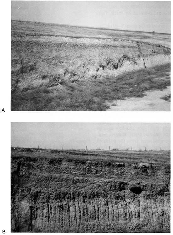
Figure 76--Cross-sectional diagram of the west wall of the Doll silo showing stratigraphic units and soils.
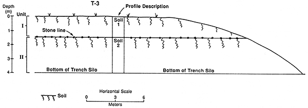
Two stratigraphic units and one paleosol were observed beneath the T-3 surface (fig. 76). The lowest stratigraphic unit (unit II) is at least 2.75 m (9.02 ft) thick and is composed of loamy alluvium. Fine sandy loam composing the lower 90 cm (3.0 ft) of the exposed portion of unit II grades upward to silty clay loam. Approximately 70% of the sediment in unit II is siliceous, with carbonate rocks making up the rest of the grains. Soil 2, which is developed at the top of unit II, has a truncated Bk horizon above a BCk horizonation. Evidence of truncation was the absence of an A horizon and a 2-cm-thick (0.8-in.-thick) stone line at the top of the 2Bkb1 horizon. The stone line is composed of well-rounded siliceous pebbles, 2-10 mm (0.08-0.4 in.) in diameter. The 2Bkb horizon (2Bkb1 + 2Bkb2) is 85 cm (2.8 ft) thick and has relatively strong carbonate morphology. About 20% of the soil matrix in the 2Bkb1 horizon has been whitened by calcium carbonate. Portions of the matrix that have not been whitened are light brown (7.5YR 6/4, dry). The 2Bkb1 horizon has common fine, hard carbonate concretions and many fine and medium, soft carbonate masses (stage II+). The 2Bkb2 horizon also has stage II+ carbonate morphology, although only 50% of the soil matrix has been whitened. Carbonate morphology decreases to stage TI below the 2Bkb1 horizon. The 2BCkb horizon is a light-yellowish-brown (10YR 6/4, dry) fine sandy loam.
Unit I is 1.45 m (4.76 ft) thick and is composed of fine-loamy sediment. The surface soil (soil 1) at the top of unit I is an Argiustoll (Mollisol) with A-ABk-Btkb-BCk horizonation. The A horizon is 35 cm (1.1 ft) thick and is a brown (10YR 5/3, dry) silt loam. Secondary carbonates appear in the ABk horizon (stage I), but the soil matrix is noneffervescent down to the Btk horizon. The Btk horizon (Btk1 + Btk2) is 68 cm (2.2 ft) thick and is a yellowish-brown (10YR 5/6, dry) to light-brown (7.5YR 6/4, dry) silty clay loam. Moderate fine and medium subangular-blocky structure has developed in the subsoil. Also, discontinuous clay films and carbonate films and threads (stage I+) were observed in the Btk horizon. The underlying BCk horizon is a light-brown (7.5YR 6/4, dry) loam. Carbonate films and threads become thicker and more common in the lower 15 cm (0.49 ft) of soil 1, and the soil matrix is calcareous based on its strong reaction to HCl.
The Finney County Soil Survey (Harner et al., 1965, sheet 56) shows the Richfield soil on the T-3 terrace at locality PR-12. The Richfield soil is developed in Pleistocene loess and is common on uplands throughout southwestern Kansas. Although unit I at the Doll silo appears to be loess, the shallow depth of secondary carbonates is not characteristic of the Richfield soil.
Based on its position in the landscape and the presence of loess on its surface, T-3 appears to be a Pleistocene terrace. The truncated paleosol (soil 2) at the top of unit II is similar to soil 2 at the top of T-3 fill at locality PR-2. The yellowish-brown to reddish color and the strong structure of these soils suggest that they are old.
Prev Page--Investigations, Large Valleys || Next Page--Evolution
Kansas Geological Survey, Geology
Placed on web July 8, 2016; originally published 1994.
Comments to webadmin@kgs.ku.edu
The URL for this page is http://www.kgs.ku.edu/Publications/Bulletins/236/02_intro.html