![]()
Prev Page--Sand Lenses || Next Page--References
Conclusions
In any study such as that of the origin of the Kansas shoestring sands the geologist is hampered by only meager data. The determination of the origin of sediments, particularly sandstones, is difficult, even where the rocks are exposed and can be studied en masse. But the shoestring sands of Kansas are buried 1,500 to 3,000 feet deep, and the few facts collected from wells were limited, in most cases, to the thickness of the sand drilled, the drill cuttings of the sand, and a few chunks and cores of parts of the sand bodies. Conclusions drawn from such data are necessarily somewhat speculative. In this study the available data have been summarized, and comparisons have been made with facts known about most common types of sandstone deposits. Certain features of the Kansas sands can be applied to any one of several types of sandstone deposits; other features appear to fit only one or possibly two types of deposits.
In summary, the following critical features appear to be significant: the narrow elongated shape of the sand bodies; the occurrence of the sand bodies in trends 15 to 50 miles long; their offset arrangement in the trends; the occurrence of gaps between sand bodies wherein little or no sand occurs; the shapes in cross section of the sand bodies; the initial dips of the bases of sand bodies; the occurrence of coarse rounded sand in sand bodies in the Quincy trend which resulted probably from wave action on a beach; the occurrence of marine fossils in the sand and in limestones in the Cherokee shale and associated with the shoestring sands in southeastern Kansas and northeastern Oklahoma; and the character of the bedding exhibited by cores of sand wherein laminae containing material of different specific gravities are sharply defined. These features have led me to conclude that the shoestring sand bodies were formed as offshore bars bordering the shores of a broad embayment on the western margin of the Cherokee sea, which occupied eastern Kansas and Oklahoma. The evidence indicates that they were deposited in two stages; the Teeter and Quincy trends were deposited first and the Sallyards and Lamont trends were formed at a later time.
A land area in Lyon county and adjacent region
This interpretation requires the presence of a land area bordering the Quincy and Lamont trends on the northeast. But few facts other than the features of the sand bodies themselves, which suggest that they are offshore bars, indicate the existence of land here. However, data that suggest the presence of a broad positive area in about the position of this suggested land area are obtained from studies of the thickness of the stratigraphic column throughout eastern Kansas. J. V. Howe11 (unpublished manuscript and oral communication) has made extensive studies of the groups of rocks that underlie the "Mississippi lime" in eastern Kansas and has found that a broad area trending northwest-southeast across southern Lyon, northeastern Greenwood, and northern Woodson counties contains a thinner column of sediments than areas to the northeast and to the southwest. The shale unit that immediately underlies the "Mississippi lime" is notably thinner here. A sketch map on Plate 1, representing the thickness of the Cherokee shale in eastern Kansas and northeastern Oklahoma, shows that the formation is thin in a broad area trending slightly south of east through Lyon, northeastern Greenwood, Woodson, Allen, and Bourbon counties. This area coincides approximately with the area delineated by Howell as containing a thin column of the older rocks. These facts suggest that this part of Kansas stood periodically at a slightly higher elevation than the adjacent regions and so received less sediment.
It is known from the character of the sediments, the fossils that are preserved in them, and the presence of old erosion surfaces, that eastern Kansas was alternately a sea floor receiving deposits and a land area subject to erosion throughout much of geologic time. The relatively thin beds in the Cherokee shale, which contain land plants and coal beds closely associated and interbedded with rocks that contain marine fossils, indicate that during Cherokee time in some parts of Kansas land and sea conditions alternated in relatively rapid succession. If the conclusion that there existed a northwest-southeast trending area in Lyon, Greenwood, and Woodson counties, which stood frequently at a slightly higher elevation than the adjacent areas, is correct, it necessarily follows that during periods of withdrawal of the sea this area would emerge earlier than the neighboring regions. At such times it would form a low barrier between the basin region of northeastern Kansas and the basin region of southeastern Kansas.
The Teeter-Quincy stage
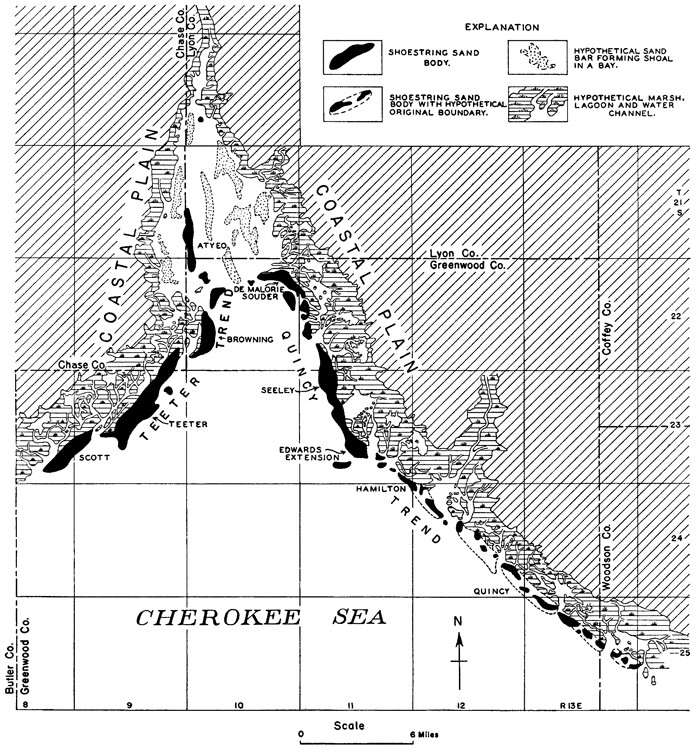
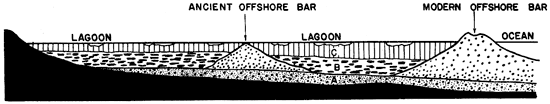
During one of the withdrawals of the Cherokee sea it is suggested that it halted for a period of time, with its western shore near the position of the Teeter shoestring trend, extending thence southwestward into Oklahoma, and with its northeastern shore at about the position of the Quincy trend. During this time, which I have designated the Teeter-Quincy stage of the Cherokee sea, a system of offshore bars was slowly built bordering the coastlines (pl. 19). The land bordering the sea is believed to have been an exceedingly low featureless expanse. The area that lay northeast of the Quincy shore probably consisted of expansive marsh flats, because it had but recently been the mud bottom of the sea. The Quincy shore line was of exceedingly simple outline, with almost a straight northwest-southeast trend through northeastern Greenwood County. Likewise the western shore, which bordered the present position of the Teeter trend, lay upon the old sea bottom, and it no doubt was also of simple outline.
Plate 19--Hypothetical sketch of a part of the Greenwood-Butler County region during the Teeter-Quincy stage of the Cherokee sea. (Sand bodies are known from records of wells; other features are hypothetical.)
It has been pointed out by Gulliver (1898-1899, p. 162) and Johnson (1919, p. 186-187) that a sea floor has very low relief, because whatever may have been the initial irregularities of the sea bottom the deposition of sediment distributed by waves and currents should have largely filled the depressions, leveled the surface, and obliterated the irregularities. Therefore, when the sea receded and the former sea floor was exposed, the new shore line which rested against the old sea bottom should have been devoid of sharp irregularities; it should tend to have a simple outline with only broad, gentle curves. An offshore bar system built parallel with the shore should likewise have a simple outline. The nearly straight-line courses of the Teeter and Quincy sand trends appear to be in harmony with the conception that they were built along a coast devoid of prominent irregularities.
Shift of the embayment
Subsequent to the Teeter-Quincy stage the shallow areas near the margins of the Cherokee sea gradually filled with sediment, the lagoons back of the offshore bars silted up, the shore lines were pushed seaward slightly, and the lagoonal marshes encroached upon the offshore bars. Inasmuch as the land bordering the sea was a coastal plain of very low relief, freshwater swamps likely bordered the saltwater swamps; and as the saltwater lagoons migrated seaward the freshwater swamps followed, but remained on the inner borders of the swamp lands. A coal bed, reported to be 5 feet thick, overlies the sand body of the Theta oil field in secs. 8 and 17, T. 22 S., R. 10 E., in the Teeter trend, and it, together with the series of sandstone and shale beds associated with it, bear evidence of this sequence of events. The offshore bars of the Teeter trend and those in the northwestern half of the Quincy trend were buried, at least in part, by the encroaching marsh and lagoonal sediments.
After this, or during this silting-up process, the broad embayment of the Cherokee sea that occupied the Greenwood-Butler County region shifted bodily eastward until its shore line stood only a few miles back from the present site of the shoestring sand bodies of the Sallyards and Lamont trends. The mechanics of the crustal deformation that caused this migration are of course not known, but a slight subsidence in the main trough of the Cherokee basin which lay 50 miles to the east (see sketch map on pl. 1.), accompanied by a slight elevation in the region of the Nemaha granite ridge which lay about 15 miles to the west, could have accomplished it. The very thick sedimentary column in eastern Kansas indicates that throughout a very long period subsidence occurred along the trough of the Cherokee basin; likewise the thinning (Reeves, 1929, p. 162) of several parts of the entire column of Pennsylvanian sediments overlying the Nemaha granite ridge area indicates periodic or continuous uplift in that region. Therefore, the supposition that some change in level occurred during that part of Cherokee time occupied by the formation of the shoestring sands seems reasonable. Students of shore lines believe that fluctuations of level and changes in the position of shore lines have been very common. In support of this view, Shaler (1893, p. 110-114) states: "Thus in the geologically brief period since the beginning of the last Glacial Epoch, or as we may fairly term it since the morning of the geologic yesterday, all the eastern coast of North America has swayed up and down in several successive oscillations ranging from a few score to a few hundred feet." Shaler's (1893, p. 112, 189) clear explanation of the shifting of the shore lines that are subjected to changes in level because of crustal movements is believed to be applicable to this Kansas region and so is quoted below.
"It is easily to be conceived that in . . . a movement of uprising land and downsinking sea floor we necessarily have a neutral or fulcrum point of the motion in the manner indicated by the diagram." (See fig. 8.) "The neutral point, or position of no motion, on a line extending from the interior of the continents to the areas of the neighboring sea basin, may occupy either of three positions in relation to the shore line. It may be just at the coast (fig. 8, A), in which case a good deal of upward and downward movement at either end of the section may take place without any alteration in the position of the shore line, or the pivotal point may be some distance within the land (fig. 8, B), in which case the movement may lead to a gain of the sea upon the continent. In the third possible condition the point of no motion may be seaward of the shore (fig. 8, C), when, though the nature of the movement may be exactly the same as before, the coast line will rise and the land gain upon the sea."
If, subsequent to the deposition of the offshore bars of the Teeter and Quincy trends, the broad region on the west flank of the Cherokee basin was tilted eastward, the fulcrum point for the movement being east of, or basinward from the west shore, the conditions illustrated in figure 8, C must have held. Both shores of the Greenwood County arm of the sea shifted eastward, the western shore migrated seaward and the eastern shore encroached upon the land that lay to the northeast. Because the land areas bordering the Cherokee sea in Kansas were coastal plains only slightly above sea level, and because the water body was probably very shallow, an elevation or depression of only a few feet would shift the shore lines several miles. The shore lines bordering the shoestring sands were shifted only 4 to 10 miles, so that the relative change in elevation that took place is believed to have been very slight. Conditions here may have been similar in some respects to parts of the Texas and Louisiana coast bordering the Gulf of Mexico, which would be inundated 15 or more miles back from the present shore line, if the area were to be depressed 5 feet or less (Barton, 1930, p. 1307).
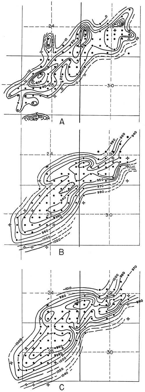
Figure 8--Fulcrum point (after Shaler). In A, B and C lines, ab represent land before the movement, a'b' after the movement; ss, position of shore line; ls, sea level; p, pivotal point. A, fulcrum point coincides with position of shore line; B, fulcrum point is on land; C, fulcrum point is seaward. Cut loaned by American Association of Petroleum Geologists.

The Sallyards-Lamont stage
After the sea shifted to its new position it again remained stationary for a period of time during which the offshore bars of the Sallyards and Lamont trends were deposited. I have designated this later period the Sallyards-Lamont stage of the Cherokee sea. The new western shore rested on the former sea bottom and so it should have had a simple outline (Johnson, 1919, p. 186-187); the new northeastern shore, however, rested upon a former land surface (Johnson, 1919, p. 172-186, 272-345), and so should have had an irregular outline, because a land surface is more irregular than a sea bottom. The offshore bars built along the borders of these newly formed shore lines appear to harmonize with these assumptions. The Sallyards offshore bar system, which bordered the western shore, forms an almost straight-line course for nearly 50 miles, the chief departures being in the form of wide sweeping curves, such as that of the sand body of the Agard oil field in the eastern part of T. 24 S., R. 9 E. In contrast, the arrangement of the sand bodies of the Lamont trend, which bordered the northeastern shore, is the most irregular of any of the shoestring sand trends in the region.
During the Sallyards-Lamont stage the western shore of the sea crossed the northeastern shore line of the earlier Teeter-Quincy stage in the vicinity of the Seeley oil field (pl. 21). It seems probable that the sand body of the Edwards Extension and Seeley fields remained mostly above sea level and projected out into the shallow water as a peninsula. The southeastern extremity of the sand body probably lay below sea level during a part of the Sallyards-Lamont stage. It may be significant that the main part of this large sand body is composed of fine and very fine sand similar to the material in the sand bodies of the Sallyards and Teeter trends, but the southeastern part of the sand body contains an increasing amount of coarse sand. The southeastern part of the Quincy trend must have been far out in the sea, 10 to 15 miles from the new northeast shore and, no doubt, the sand bodies there were below sea level. In this position the waves must have attacked these sand bodies and attempted to destroy them, because they formed irregular promontories on the sea floor. The fine material of the sand bars was readily removed under ordinary weather conditions, but the coarse material no doubt had a tendency to remain, except when subjected to the forces of strong storm waves and currents. Consequently, it does not seem improbable that parts of the old offshore bars that were built here during the Teeter-Quincy stage might have escaped destruction under the new set of conditions. At any rate, it is a fact that numerous sand bodies composed of material that is much coarser than that of most of the large bar-shaped sand bodies in the region have been found by wells in an almost straight line course trending southeastward across the eastern part of Greenwood County. The assumption is that they are remnants of former large offshore bars that were partially destroyed not long after they were built. It is not believed, however, that the abundance of medium and coarse sand in the sand bodies here is due mainly to concentration by the removal of the finer particles subsequent to the formation of the sand bodies. The sand bodies of the Quincy trend were no doubt built originally of much coarser sand than that which forms the greater part of the sand bodies of the other trends.
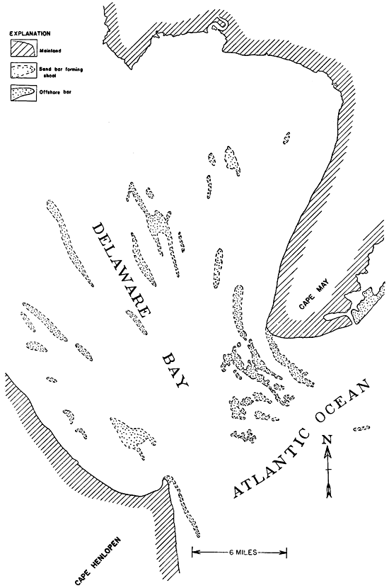
The sand body of the Atyeo oil field in Tps. 21 and 22 S., Rs. 9 and 10 E., does not appear to fit into this scheme. Its position is outside the trend of the principal systems formed by the other sand bodies; its orientation is at variance with other sand bodies nearby, and it is composed of material that is of much coarser grain than that of the sand bodies near it. As shown on Plate 19, the Atyeo sand body is represented as an elongated bar in a narrow bay, protected from the storm waves of the open sea, but subject to strong tidal currents that must have surged in and out of the bay mouth. Chesapeake Bay, Delaware Bay, and other bays on the Atlantic coast contain numerous sand bars aligned approximately at right angles to the trend of the coast line, but approximately parallel with the trend of the bay, similar to the hypothetical position shown for the sand body of the Atyeo field. Streams that enter Chesapeake Bay and Delaware Bay are constantly dumping sediment into the bays and the stream and tidal currents sort it and distribute it. Part of the sediment is carried out to sea, but much of it is built into elongated sand bars in the bays, as shown in figure 7, which is a part of the United States Coast and Geodetic Survey chart 1218, showing the Delaware Bay region.
Figure 7--Sketch of a part of Delaware Bay. (After U. S. Coast and Geodetic Survey Chart 1218.)
Explanation of certain features of the sand bodies
If the Seeley-Edwards Extension sand body projected seaward as a narrow peninsula during the Sallyards-Lamont stage, the coast line that lay northwest of it near the present position of the Wick oil field would have been protected from the sweep of southerly winds and so would not have been washed by strong waves. Contrasted with this protected position, the shore at the localities of the Burkett and Thrall sand bodies and elsewhere southward along the Sallyards trend faced a great expanse of open sea where the easterly and southerly winds had a long sweep. These ancient coasts were no doubt similar in many respects to our present coasts, which have well-developed offshore bars bordering the stretches that face the open sea, but few or no bars on the protected parts of the coasts (Wilson, 1908, p. 499). The facts known about the Greenwood County sand bodies appear to fit the expectations. The sand lenses of the Burkett and Thrall oil fields have typical bar-shaped forms, and they are thick bodies composed almost entirely of sand. The sand body of the Wick field consists of interbedded sand, shale, and sandy shale, and but little could learned from studies of the well logs about its shape in cross section. The sand body of the Madison field adjacent to the Wick field on the northeast is a thick lens composed almost entirely of sand. Because the locality of the Madison body of sand was removed several miles from the Seeley-Edwards Extension sand body, its shore faced a broad area of the sea to the east over which the winds were able, no doubt, to generate comparatively large waves.
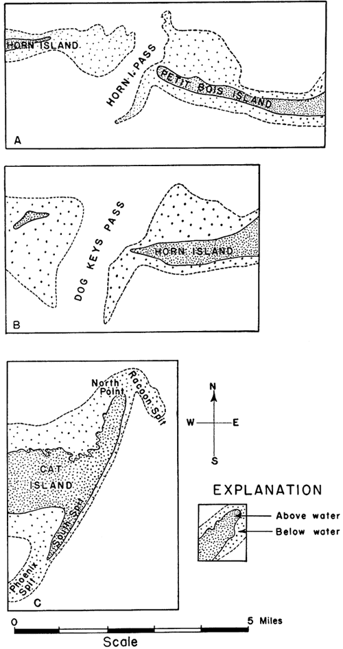
The main sand body of the Madison oil field trends northeast-southwest through the northeastern part of T. 22 S., R. 11 E., but a narrow prong of oil-bearing sand projects eastward from its south end into secs. 14 and 23, as shown on Plates 1, 11, 20, and 21. Dry holes that found no sand east, south, and southeast of the oil wells fairly well establish the boundaries of the sand body in those directions. The oil well in the NW SE SW sec. 14 found only a thin bed of sand which, with the dry holes farther to the northeast in sec. 14, fairly well defines the east margin of the main sand body and so fixes the north boundary of the eastward trending prong within fairly narrow limits. Considerable speculation has been made concerning the origin of this prong of sand. Examination of coast charts of the Atlantic and Gulf coasts of the United States reveals that features similar to this are fairly common on our modern coasts. They are parts of tidal deltas (Johnson, 1899, p. 374; Davis, 1899, p. 353) that are built by the tidal currents as they flow in and out of the tidal inlets between the offshore bars. The inflowing current carries debris into the lagoon and the outgoing current carries sediment seaward. It is only in the narrow part of the inlet where the current is swift that the sediment is freely transported; it is dropped close by where the outgoing current enters the sea and where the incoming current comes in contact with the fairly still water of the lagoon. The greater development is most commonly on the lagoon side, because the waves and longshore currents tend to destroy the delta on the seaward side. If the waves and currents are weak, however, the seaward side may develop prongs of sand projecting seaward on each side of the tidal inlet; such prongs are called spits. Figure 9 shows features bordering offshore bars on the coasts of Alabama and Mississippi that are strikingly similar in plan with the prong on the south end of the sand body of the Madison field.
Plate 21--Hypothetical sketch of a part of the Greenwood-Butler County region during the Sallyards-Lamont stage of the Cherokee sea, showing shore features of the Teeter-Quincy and Sallyards-Lamont stages.
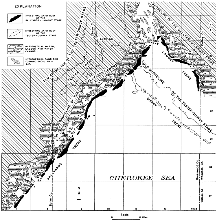
Figure 9--A, B and C, Spits bordering tidal inlets on north coast of Gulf of Mexico. (After U.S. Coast and Geodetic Survey Chart 1267.)
Recent drilling in secs. 28, 29, 32, and 33, T. 23 S., R. 11 E., south of the Edwards Extension oil field, has shown the presence of a body of sand there, which may be similar in origin to the prong of the Madison body of sand--that is, it may be part of a tidal delta.
Many of the tidal inlets of the offshore bar systems on the Atlantic and Gulf coasts have a double channel separated by a small island of sand; the Hereford inlet near the southeast end of the offshore bars bordering the New Jersey coast, shown on Plate 20, illustrates this feature. The small body of sand in sec. 7, T. 23 S., R. 11 E., between the Burkett and Seeley fields, bordered by two narrow areas shown by dry holes to contain no sand, is believed to represent this type of coast feature. The areas containing no sand, of course, represent the old tidal inlet channels, and the sand body represents the island between the channels. The small sand bodies in Tps. 26 and 27 S., R. 8 E., northeast of the Seward field, may be other examples.
Numerous wells near the main sand bodies, but somewhat outside the trend, have found thin beds of sand and a considerable thickness of sandy shale. Many of them have yielded good shows of oil and a very few have produced oil in commercial amount. Wells of this type include: the well in sec. 14, T. 23 S., R. 10 E. (color omitted from pl. 1), half a mile west of the Burkett pool; the well in sec. 22 (color omitted from pl. 1), of the same township, also west of the Burkett pool; the well in the SW SE SE sec. 24, T. 24 S., R. 9 E., east of the Agard pool and surrounded by dry holes, and many others shown on Plate 1. Inspection of charts of our present coastal areas suggests a plausible explanation of these erratic occurrences of sand. Islands of mud and sand occur distributed irregularly through the lagoons between the offshore bars and the land. Water wells drilled on some of these islands along the New Jersey coast are reported to have penetrated sand, muddy sand, and silt (New Jersey Geological Survey, Annual Reports). Dredging operations carried on in the lagoonal swamps for opening canals between the thoroughfares are reported to have found the material in some places to be sand in thin layers overlying mud; in others mainly mud or silt, with some sand (New Jersey Geological Survey, Annual Report, 1907, p. 43).
Seaward from the offshore bars the coast charts show low ridges and mounds of sand in many parts of the coast. If the shoestring sand systems represent offshore bar deposits, as seems a logical conclusion, then it should be expected that small, thin sand deposits should occur irregularly distributed through the bordering areas, just as they occur on our present coasts. In most localities the sand possibly has too low porosity to serve as a reservoir for oil, because it contains so large an amount of silt. In some localities a thin bed of fairly clean sand may be oil-bearing. Such deposits are so irregularly distributed on modern coasts that an example filling every conceivable condition with respect to the main sand bodies probably could be found on the coast charts. Occurrences of small sand bodies bordering the shoestring sand trends appear to be equally as irregular. The coast charts indicate that fairly large bodies of sand occur in large embayments behind the offshore bars; the irregular shoestring sand bodies in the northeastern part of T. 25 S., R. 8 E., may represent deposits of this type. However, speculation as to the particular type of deposits that the small sand bodies outside the trends represent is about as hazardous as prospecting for them with the drill.
Although the sand recorded in several wells in Lyon County, north of the trends, occurs somewhat above the stratigraphic position of the shoestring sand, the logs of some wells record sand containing water at the horizon of the shoestring sand. Some geologists have interpreted these occurrences as representing extensions of the Teeter and Sallyards trends. However, they may represent irregularly distributed deposits of sand that were wind-laid or stream-laid on the low land that bordered the sea during the Teeter-Quincy and Sallyards-Lamont stages of the Cherokee sea.
Source of the Shoestring Sand Sediments
According to Johnson (1919, p. 365-366) offshore bars on our modern coasts are built largely by waves that collect material from sediments on the shallow sea bottom. Prior to deposition on the sea floor the sediments no doubt were eroded from the neighboring land and carried to the sea largely by streams. Some of the material of offshore bars commonly is supplied by marine erosion of stretches of the shore (Davis, 1909, p. 707-712) that are attacked directly by the waves, but according to Johnson (1919, p. 365-366) generally the sediments derived in this manner form a small portion of the total material in the offshore bars.
Most of the bar sediment in many modern bars is of relatively local origin. Colony (1932, p. 150-159) found that much of the material in the offshore bars that border the Long Island and New Jersey coasts is similar to the rocks that comprise the land sediments of the adjacent regions, which constantly are being eroded and carried onto the shallow sea bottom by the streams. A portion of the sands of the offshore bars migrates slowly along the bars, however, and may finally come to rest far from its source. Martens (1931, p. 531) has shown that grains of feldspar have traveled 400 miles or more southward along the southeastern coast of the United States; and Shaler (1894, p. 208) states that observations from New York to Florida show that beach sands are migrating southward; and again he speaks of "the sand beaches, the debris of which has journeyed great distances from the north" (Shaler, 1893, p. 188).
By analogy it appears probable that the material of the shoestring sand bodies of Greenwood and Butler counties was scoured from the Cherokee sea bottom, near the localities where the sand bodies occur today.
The relative uniformity of the material in the Sallyards, Teeter, and Lamont sand systems indicates that most of the offshore bars of these systems were built from the fine sands concentrated from a sea bottom containing relatively homogeneous material. The pronounced offset relationship of the offshore bars that are developed so uniformly in the Sallyards and Teeter systems strongly indicates that longshore drift of material likely played an important part in the final distribution of the sands. The coarse, well-rounded sand that characterizes the sand bodies for a distance of about 20 miles of the Quincy trend could be accounted for by assuming that a stream which drained parts of the land mass in Lyon, Morris, Geary and adjacent counties entered the Cherokee sea in northeastern Greenwood County; coarse sediment gathered from the land would have been dropped by the stream in a restricted area near the stream's mouth, and later brushed up by the waves and built into offshore bars by the action of waves and longshore currents.
The rounding of the grains of the coarse sand in the Quincy trend could have been accomplished by wave action; it is known that coarse material on modern beaches is generally more rounded than the fine material. It might be argued that the coarse sand was rounded by the wind on the land before it was carried into the sea. Modern coasts are commonly bordered by areas containing sand dunes, and so portions of the Cherokee sea coast were probably bordered by sand dunes. If such were the case, waves and longshore currents which reached the mainland promontories would have cut into the dune sands and distributed the sand along the offshore bars, or streams that crossed a sand dune area would have carried the dune material into the sea, to be later brushed up by waves onto the bars. However, dune sand (Twenhofel, 1932, p. 69) is commonly much finer grained than the rounded sand found in the shoestring sand bodies. It appears almost certain, therefore, that the sand grains were rounded by waves rather than by the wind.
The concentration of the coarse material in the sand bodies in part of the Quincy trend may have been accentuated during the second, or Sallyards-Lamont stage, of offshore bar construction, during which time it is believed that these bars stood below the water surface and were undergoing destruction while the offshore bars of the Lamont system were being thrown up near the new shore. The waves that swept across these old bars would have had a tendency to remove the finer material and to concentrate the coarse sand in the deposit that remained.
According to the scheme presented here, after the first offshore bar system was built the sea transgressed northeastward onto the land in northeastern Greenwood County and southeastern Lyon County. Consequently, the offshore bars which were subsequently thrown up bordering this coast might be expected to contain coarse material derived from land promontories that may have reached the sea. The sand bodies of the Sallyards system which were built on the old sea floor might be expected to contain finer sand. It is a fact that the lower part of the sand body of the Shambaugh field in the Lamont trend is reported by oil operators to contain considerable coarse sand that is well rounded; the sand body of the Lamont field contains a higher portion of coarse, well-rounded sand than the sand bodies of the Sallyards and Teeter trends; but the sand body of the Fankhouser field has a lesser portion of coarse, well-rounded sand than those of the other fields in the Lamont trend; its sand closely resembles the fine sand of the sand bodies in the Sallyards and Teeter trends.
If the sand of the shoestring sand bodies was derived from the Cherokee sea bottom, it must have had its original source in the same localities that supplied the muds of the shale beds that now underlie it. A similarity of composition of the sands in different localities in Greenwood, Butler and Cowley counties, Kansas, and Osage County, Oklahoma (Bass et al., 1936, p. 8), indicates that they had a common source. The heavy minerals isolated from drill cuttings and cores from the shoestring sands in Greenwood County were studied a few years ago by geologists with the Empire Oil & Refining Co. (F. T. Clark, personal communication). They found like minerals in all the sand trends, which indicates that the sand of all of the shoestring bodies had a common source. Inasmuch as a rather extensive land area probably lay west and northwest of this part of the state in early Cherokee time (sketch map on pl. 1), it doubtless furnished some of the lowermost Cherokee sediments of the western part of the basin, including Greenwood and Butler counties. Material identified by J. S. Barwick (personal communication) in well samples of the producing sand of the Atyeo oil field in Tps. 20 and 21 S., Rs. 9 and 10 E., indicates that it was probably derived from Ordovician and Mississippian beds, and the feldspar grains that comprise a small portion of the shoestring sands may have been derived from rocks of the basement complex which were exposed not many miles to the northwest in the Nemaha granite ridge area. The somewhat large portion of feldspar grains in core samples of the sand of the Madison field, which R. J. Colony (letter to D. W. Johnson) stated occurred in much greater abundance than in the modern offshore bars that border the New Jersey and Long Island coasts may be satisfactorily accounted for: granitic rocks yielding weathered feldspar fragments are believed to have been exposed only a few miles northwest of the old shore lines. It is not surprising that feldspar material reached the coasts in fair abundance; the lack of vigorous wave action, such as the Atlantic coast experiences, would account for the preservation of the feldspar grains. Marine beds in California are reported to contain more than 25 percent feldspar (Reed, 1933, p. 126-127, 149-150, 243).
A relatively small land mass probably existed on the east side of the Cherokee basin in the region of the present Ozark Mountains of Missouri (Hinds and Greene, 1915, p. 39-40) and shed sediment into the Cherokee basin of Kansas, Missouri and Oklahoma. More remote sources, such as Llanoria, an ancient land mass that lay southeast of Arkansas and, according to Miser (1921, p. 61-89; see also Moore, 1929, p. 483-484, 486-487), furnished most of the Paleozoie sediments of the Ouachita Mountains and Arkansas Valley region of Arkansas and Oklahoma, probably account for a portion of the Cherokee sediments of Kansas. It seems likely that in a shallow sea, such as the Cherokee sea is believed to have been, waves and currents distributed the sediments widely. It is probable that some sediment from Ozarkia in Missouri and Llanoria in Louisiana, and perhaps other land areas remotely located, found its way to the western shores of the Kansas part of the Cherokee sea and were mingled with the muds from the nearby lands.
Preservation of the Offshore Bars
As pointed out by Gilbert (1890, p. 101), shore features are some "of the most perishable of geologic phenomena." Consequently, some unusual combination of favorable conditions would appear to be necessary to permit the preservation of offshore bars. The method of deposition of the shoestring sands proposed that the western margin of the Cherokee basin was elevated subsequent to the deposition of the Teeter and Quincy sand trends. This elevation should have subjected the sand bodies of the Teeter trend to erosion unless they were protected in some manner. The fact that the sand bodies of the Scott, Teeter and Browning oil fields fail to show any erosion features indicates that little or no erosion occurred. The elevation was presumably so slight and so gradual that these earlier offshore bars were actually buried by muds and swamp debris before the sea retreated. The land that bordered the sea is thought to have been an expansive coastal plain and swamp land that stood only a few feet above sea level, where streams were able to accomplish but little erosion. Furthermore, the withdrawal of the sea was not accomplished by deformation alone. The first stage of the seaward migration of the shore was probably brought about by the silting-up of the basin margins. The bed of coal, 5 feet thick, that overlies the sand body of the Theta oil pool in T. 22 S., R. 10 E., indicates that the saltwater lagoons were gradually silted up and cut off from the sea, and as the seashore was pushed seaward, freshwater swamps occupied the old sites of the saltwater marshes.
Incidentally, the coal bed bears evidence of the very long time consumed in the accomplishment of some of the events believed to have taken place in connection with the deposition of the shoestring sands. On the assumption that it required a century to form 1 foot of compressed peat, 3 feet of which were required to form a bed of coal 1 foot thick (Ashley, 1907, p. 45), the small coal lens above the sand in the Theta oil pool required 1,500 to 2,000 years of plant growth. The time consumed in the accumulation of the vegetation that resulted in this coal lens is but a small part of the period involved in the deposition of the shoestring sand bodies.
There are a number of localities on our modern coasts where old offshore bars are now part of the coastal plain and are bordered on the seaward side by swamps and newer offshore bars; according to Shaler (1893, p. 187) examples may be seen at many places along the eastern shore of Florida. Shaler (1885, p. 382) described an area on the coast of Massachusetts where an ancient offshore bar lies in the midst of the lagoonal marsh that lies behind a newly formed offshore bar which has been built some distance seaward. Parts of the ancient bar are exposed above the marsh debris, and it forms a disconnected ridge in the midst of the marsh. Shaler's cross section showing the relationship of the old and new offshore bars is reproduced in figure 10.
Figure 10--Diagrammatic section through Plum Island, Mass. (After N. S. Shaler.) A, Sand and gravel; B, Eelgrass; C, Upper marsh.
In 1935, after preparing this report, I examined an ancient offshore bar that lies landward behind a lagoon and a recently built offshore bar about 11 miles southeast of Wilmington, N. C. A steep-sided canal, which is a part of the intracoastal waterway, has been dredged through the old bar and exposed it in part in cross section. (See U. S. Coast and Geodetic Survey charts 1235 and 425.) The walls of the canal are black, made so by black carbonaceous material that coats the sand grains and partially fills the interstices between the grains. The carbonaceous material was removed from a sample of the sand by heat, and the residue was found to be composed mainly of quartz grains similar to the other beach sand nearby.
The few localities cited where offshore bars are being buried and preserved on our modern coasts would appear to establish that under favorable conditions their preservation can be accomplished. The low swampy coastal plain that is believed to have characterized the region bordering the Cherokee sea in Kansas appears to have provided conditions that were more favorable for the burial and preservation of shore features than those cited on our modern coasts.
Origin and Accumulation of Oil in the Shoestring Sands
Much has been written concerning the origin and accumulation of oil, and it is beyond the scope of this report to discuss at length the theories advanced or even to cite many references to writings on the subject. Most petroleum geologists are agreed that the preponderance of evidence indicates that oil has evolved by the partial decomposition of plants and animals buried with the sediments, but they differ in their opinions as to whether the oil originated as particles widely disseminated in the sediments, or formed in some abundance in locally restricted areas; wide divergence of opinion exists as to the manner of accumulation, or segregation and concentration of the oil into the reservoir rocks in which it is found today. With essentially the same data at hand, one group of geologists (Rich, 1921, p. 347-371, 1931a, p. 911-924, 1931b, p. 1431-1452) defend the thesis that oil originates elsewhere than at the localities of its present abode and subsequent to its creation has migrated considerable distances through the rocks and has been concentrated locally in porous reservoir beds. The thesis (Clark, 1934, p. 309-335) of the other group is, briefly, that the oil found in oil fields originated in the sediments that make up the reservoir rocks or in beds closely associated with them, at or in the very near vicinity of the localities where it is found today. The followers of this school of thought believe that oil has not migrated, except very locally.
The Kansas shoestring sand oil fields may be important "keys" to the correct explanation of the occurrence of oil in at least one type of oil field. The shoestring sands are relatively small lenses of porous beds surrounded by dense, fine-grained shale, which probably forms an effective barrier to fluids that strive to migrate into or out of the porous sand lenses. Chemical analyses of waters from the shoestring sands compared with analyses of water from the "Mississippi lime" 50 to 150 feet below, show marked differences in composition, indicating that there is no communication of liquids in appreciable amounts across the shale beds. Sufficient differences in character of waters (Bash, 1932) from the shoestring sands at localities 25 to 30 miles apart appear to indicate that there is a lack of lateral movement of liquids through the sand lenses, except locally, and certainly indicates a lack of movement from one lens to another. Therefore, the occurrence of oil in the shoestring sand lenses would tend to show that it originated in the sandstone sediments and in the sediments that occur close by, because the few facts available indicate that it has not migrated far through the impermeable shale strata associated with the reservoir beds.
Assuming that the shoestring sands were deposited as offshore bars bordering a sea, the environment in the sites of their deposition should have been favorable for abundant accumulation of probable oil-forming organisms. It is a well-known fact that the lagoons on the landward side of modern offshore bars and the shallow waters on the seaward side contain abundant life. As pointed out by Shaler (1893, p. 155) the constantly shifting sands and tidal inlets, and the storms that frequently strike the coasts bring about a high mortality of many types of living forms, both animals and plants. The same waves and currents that destroy the life also grind the plant and animal remains on the beaches and bottoms and carry them into shallow waters and the lagoons, where they form a constantly replenished food supply for the abundant life that exists there. The accumulation of sediment goes on here at a fairly rapid rate, insuring quick burial of the abundant remains of the abundant life. Accordingly, insofar as the shoestring sands of Greenwood and Butler counties are concerned, the few data available appear to indicate that the sand bodies were deposited in an environment that was favorable to the occurrence in abundance of plant and animal organisms whose remains might contribute oil to the local sediments. These data indicate that the oil now found in the sand bodies likely originated locally, within a mile or so laterally of its present abode, and within a few feet stratigraphically of the rocks in which it occurs. The data do not indicate that the oil was originally widely disseminated in the Cherokee shale or other formations and later was concentrated in pools by migration laterally through a distance of several miles or vertically through an interval of several hundred feet.
Possibility of Discovering Additional Shoestring Sand Oil Fields
The oil producer is interested in the interpretation of the origin of the shoestring sand bodies primarily to whatever extent it enables him to discover more oil fields. If studies of the facts revealed by the development of the oil fields indicate the locations of untested areas that are prospectively valuable for oil, they are of very practical worth. Such interpretations are believed to be possible from the study of the shoestring sand oil fields. For instance, it has been shown that buried river channel deposits should exhibit certain characteristics that are in many ways decidedly different from those of coastal features, such as offshore bars. The correct interpretation of the origin of the known sand bodies is accordingly essential to the projection of their trends into undrilled areas and is particularly important in interpreting the information disclosed by prospect holes that fail to locate a new sand body. A geologist or operator attempting to extend the shoestring sand trends into undeveloped territory will project a circuitous, irregular pattern beyond the known oil fields if he believes that the sands were formed by the filling of stream channels, but will plot approximately straight line projections arranged in an offset pattern if he believes that the sand bodies originated as offshore bars similar to the bars on our modern coasts.
It is reported that more than 75 percent of the present coast lines of the world are fringed with beach sand deposits. On the Atlantic coast, offshore bars form an almost unbroken chain of narrow, elongated islands from the south coast of Long Island to the tip of Florida, and except for a few gaps fringe the coast of the Gulf of Mexico from Florida to beyond the Rio Grande. It takes but little optimism to conclude that offshore bars were formed along the ancient shores of the Cherokee sea for many miles beyond the present known extremities of the shoestring sand trends. It is possible, however, that even though additional offshore bars than those now known were formed, they may not have been preserved.
Shore features are perishable (Gilbert, 1890, p. 101), and it is only under the most favorable set of conditions that they are not destroyed. The physical conditions under which the shoestring sand bodies were buried are perhaps more difficult to reconstruct than those that made possible the deposition of the sand. But it is known that continuous trends of sand bodies throughout a linear distance of more than 50 miles were preserved. Recent studies of oil-bearing sand bodies in Osage and Kay counties, Oklahoma (Bass et al., 1936), 60 to 70 miles south of this area, indicate that they were deposited by a similar method, under like environment, and at about the same time as the shoestring sands of the Butler-Greenwood County region. These facts prove that conditions favorable for the preservation of sand bodies prevailed over a fairly large region in Kansas and Oklahoma and indicate that such environment prevailed elsewhere in the region.
The Sallyards trend has scarcely an interruption throughout its known length of 45 miles, except the few local barren areas between the sand bodies that are believed to represent the former sites of tidal inlets, and so should normally be expected to contain little or no sand. Likewise, the Teeter trend is composed of relatively large, fully developed sand bodies, separated by narrow stretches marking the sites of tidal inlets. The abrupt terminus of the Sallyards trend at the southwest end of the Keighley oil field (sec. 33, T. 27 S., R. 7 E.) and of the Teeter trend at the southwest end of the Scott oil field (sec. 23, T. 23 S., R. 8 E.) appears not to be the natural thing to expect. It is my belief that the Sallyards and Teeter trends will be extended southwestward and the Haverhill trend will be extended southward toward Oklahoma, and it appears probable that they, together with some of the sand bodies in Osage County, Oklahoma, are parts of a continuous shoreline system. There are extensive areas in Cowley County, Kansas, and Kay County, Oklahoma, that lie between the Burbank, Rainbow Bend, Burden and other shoestring sand oil fields that should be thoroughly prospected for sand bodies that likely were deposited there during the Teeter-Quincy and Sallyards-Lamont stages of the Cherokee sea.
Plate 18--Maps of the Scott oil field in T. 23 S., Rs. 8 and 9 E. A, Map showing thickness of the shoestring sand (lines connect points of equal thickness). B, Subsurface structure contour map of upper surface of the shoestring sand. C, Map B redrawn after the regional structure shown on Plate 7 had been eliminated.
Development has shown that the sand bodies in the Quincy and Lamont trends commonly occupy small areas, and so they are difficult to locate. However, the drilling depths are only about 1,500 feet here, and many tests can therefore be made at no great expense. It thus appears reasonable to conclude that additional oil and gas pools in shoestring sand bodies will be found in extensions southeastward from the known Quincy and Lamont sand trends.
The general scheme of a fluctuating inland sea in eastern Kansas which halted, at least twice, sufficiently long to permit shore features, such as offshore bars, to be built, and coal beds of considerable thickness to accumulate in low lands not far removed, suggests that these phenomena were not necessarily limited to two stages; there may have been others. The western shore of the Cherokee sea likely migrated across northern Butler County, between the eastern gentle slope of the Nemaha granite ridge and the Teeter shoestring trend. It is not impossible that at one or more periods the shore remained fixed sufficiently long to permit the waves to throw up a series of offshore bars, which may have been buried by later sediments and preserved. Also, theoretically, one might conjecture further that at the period of formation of the shoestring sands, offshore bars probably formed all along the ancient shores on the west and east sides of the Cherokee sea in Kansas, and that they therefore should be found swinging northward around the old land barrier that extended eastward across Woodson and Allen counties, thence trending northwestward through Franklin and Osage counties, northward through eastern Wabaunsee County, thence northeastward through Shawnee, Jackson and Nemaha counties, possibly into Nebraska.
If I may presume to offer a bit of advice I would like to caution operators to prospect in a projection of an established sand trend, to remember that offshore bars and the developed shoestring sand bodies have an established offset arrangement, and that there are barren gaps between modern offshore bars and between the developed shoestring sand bodies, that the information disclosed by the developed oil fields overwhelmingly indicates that the shoestring sand bodies were deposited as offshore bars and you should therefore expect them to occur in systems or trends that exhibit features strikingly similar to the modern offshore bars on our own Atlantic coast. Features of modern bars are admirably shown by the coast charts of the Atlantic coast between northern New Jersey and southern South Carolina, published by the United States Coast and Geodetic Survey.
Prev Page--Sand Lenses || Next Page--References
Kansas Geological Survey, Geology
Placed on web May 3, 2011; originally published Sept. 1936.
Comments to webadmin@kgs.ku.edu
The URL for this page is http://www.kgs.ku.edu/Publications/Bulletins/23/06_conc.html