![]()
Prev Page--Structure, Development, Distribution || Next Page--Conclusions
Shapes of the Individual Sand Lenses
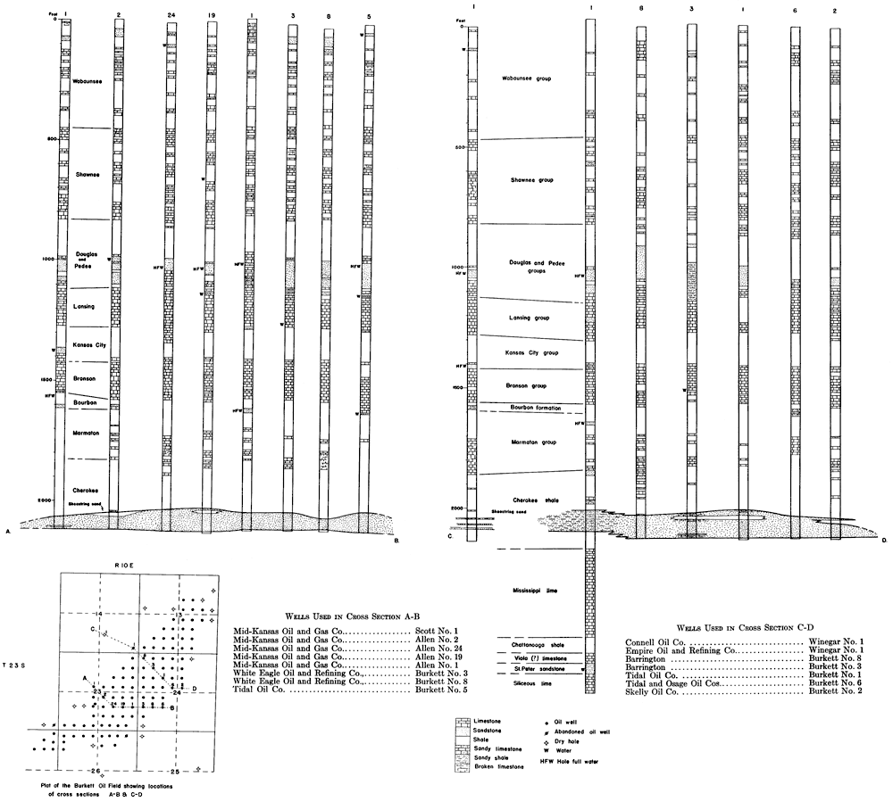
Aside from a study of the areal distribution and arrangement of the sand trends, several individual sand bodies were studied in detail from the records of the oil wells drilled into the sand and dry holes drilled nearby outside the boundaries of the sand bodies. The detailed studies were confined largely to the oil fields occurring in Tps. 22 and 23 S., Rs. 8 to 13 E. (see pl. 1), but some work was carried on in fields outside this area. Several score cross sections were made on a large scale (vertical scale, 50 ft to the inch, and horizontal scale, 145 ft to the inch) across the shorter dimensions of the sand bodies. The large scale of the cross sections revealed details of the curvature and slopes of the upper and lower surfaces and the stratigraphic irregularities of the sand that are not so evident on a smaller scale.
In many of the cross sections the sand appears to be an irregularly shaped body, lacking any systematic form of either its top or base. In a few localities the well logs show the sand at different stratigraphic horizons in offset wells. However, after making graphic cross sections along each row of wells in directions approximately at right angles to the longer axis of the oil fields, certain features appear to be common to the greater number of the cross sections and certain fairly definite conclusions were drawn from the study of all the sections. A few of the cross sections are reproduced in figure 3. A description of several sand bodies is given on the succeeding pages.
The Sand Body of the Burkett Oil Field
The wells in and adjacent to the Burkett oil field, which occupies parts of secs. 13, 14, 22, 23, 24, 26 and 27, T. 23 S., R. 10 E., and sec. 18, T. 23 S., R. 11 E., were drilled after most of the other shoestring sand fields in this part of the state had been developed. As the well logs were more accurately recorded than for some of the earlier wells, the data they make available are fairly reliable for study. Furthermore, the sand in the Burkett field contains so little water that most wells were drilled entirely through the sand into the shale below. Accordingly, the well logs record the total thickness of the sand body.
Numerous sections were made across the sand body by comparing graphic well logs, having a vertical scale of one inch equals 100 feet, by the usual method of laying the plotted log strips side by side and matching up the series of strata, chiefly limestone beds, recorded in the logs; two of these cross sections are shown on Plate 9. Numerous cross sections showing only the producing sand were plotted, using a vertical scale of 1 inch equals 50 feet; one of these is shown in fig. 3. Finally, the logs of all wells in the field and dry holes near the field were compared and the stratigraphic position of the sand was determined in each well.
Plate 9--Cross sections in the Burkett oil field, Greenwood County. An Acrobat PDF version of this image is available.
It was found that the base of the producing sand has a lower stratigraphic position in the Phillips Petroleum Co.'s W. H. Edwards No. 10 well, in the northwest corner of the NE SE sec. 13, T. 23 S., R. 10 E., near the northeast margin of the field, than anywhere else in the field.
With the log strips matched and arranged side by side, a horizontal line drawn across all the log strips, so as to coincide with the base of the sand in the log of Edwards No. 10 well, fell below the base of the sand in all other logs, because the sand is not so low stratigraphically in any of them as it is in the Edwards No. 10. Inasmuch as the logs are correlated on stratigraphic horizons, the points on the logs where this horizontal line falls should represent points on a horizontal plane below the sand body at the time of deposition of the sand. (It is assumed that the limestones matched in the logs were horizontal when deposited.) Using this plane as a base, a block diagram showing the sand body and the shale immediately beneath the sand was drawn as shown on Plate 10; no logs were discarded and the sand was plotted just as recorded in the logs. The diagram is drawn in perspective and the vertical and horizontal scales diminish progressively toward the background. The diagram represents numerous cross sections running in an east-west direction and others running north-south.
Plate 10--Block diagram of the producing sand in the Burkett oil field, T. 23 S., R. 10 E., Greenwood County. Horizontal scale, wells spaced 660 feet apart. Vertical scale, sand in Burkett No. 4 well in SE cor. SW NW sec. 24, is 100 feet thick. Both horizontal and vertical scales decrease progressively toward the background. Data from drillers' logs. NOTE: Most wells were drilled through the sand body into shale; the shale shown below the sand in some wells is hypothetical and in nearly all wells shale is shown here to greater depth than actually penetrated by the drill. An Acrobat PDF version of this image is available.
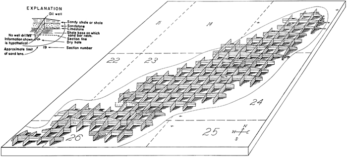
The block diagram (pl. 10) shows that in general the base of the sand was higher (distance above the horizontal plane) in the westernmost part of the field at the time of deposition than in the easternmost part--that is, it was deposited on a surface that at the time of deposition sloped eastward at a very low angle. The diagram shows that the sand is thickest in the central part of the field and thins toward the margins, forming a large lens-shaped body; the lowermost part of the sand is the most widespread. The upper surface of the sand body is convex upward; the lower surface approaches very closely a plane that had an initial dip of slight degree to the east. The position of the sand as recorded in a few wells in the field does not appear to fit the scheme developed by the others. The sand is shown much higher in the well in the NE SE SW sec. 23 than in any of the wells close by. It is probable that the depth to the sand in this well was recorded incorrectly or that the log record was copied incorrectly. The sand is plotted on Plate 10 at the position recorded in the log, but its probable correct position as interpreted by me is indicated by dashed lines.
The dry hole symbols in the northeasternmost part of the diagram show wells that encountered no sand at the horizon of the producing sand. A little farther south along the eastern margin of the field, a dry-hole symbol is shown beside a well that encountered a thin bed of sand in the lowermost few feet of the sand horizon but found it barren of oil. It is noteworthy that, after a few dry holes have been drilled near the margin or just outside the margin of a sand lens, the operators are able to define the boundaries of the field within certain limits and save the drilling costs for additional holes at the borderline locations. The diagram indicates that if a well were drilled in the northeast corner SW sec. 24 it would find the producing sand body comparatively thick. The sand is 90 feet thick in the offset well to the north and in the offset well to the west, but each of these wells yielded only small amounts of oil. The low yield of oil suggests that parts of the beds reported as sand probably contained a large portion of sandy shale, or tightly cemented sand having very low permeability. It is probable that a well that would have produced a fair amount of oil could have been completed in the northeast corner SW sec. 24 during the early development of the field, but it may be that much of the oil that earlier surrounded this location has by now migrated to the offset wells on the north and west. A well similarly situated was drilled recently in the Agard oil field in T. 24 S., R. 9 E., and yielded only a small daily volume of oil.
The sand body pinches out rather abruptly in the southeasternmost part of the Burkett field, and limestone and shale occupy its horizon. The margin of the sand lens probably crosses the northeasternmost part of sec. 26 and the southeasternmost part of sec. 23; it lies west of the two dry holes in the northwest corner of sec. 25 and the southwest corner of sec. 24. The logs of the wells indicate that the sand body is more variable in thickness and shale content in the western part of the field than in the eastern part. The sand body tapers southeastward toward the margin with a fairly uniform gradient, but in the western part of the field some wells show thick sand and offset wells record mostly sandy shale with only thin beds of sand.
The Sand Body of the Madison Oil Field
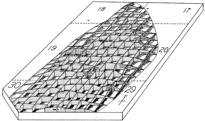
The Madison oil field is the northernmost large field of the Sallyards shoestring trend; it occupies parts of secs. 1, 10, 11, 12, 14, 15, 22, and 23, T. 22 S., R. 11 E. A large number of cross sections, based on well logs, were drawn approximately at right angles to the longer axis of the field and the producing sand was found to be similar to that in the Burkett oil pool, in that the base of the sand forms approximately a plane surface that had an initial slope eastward at a low angle. After making a study of cross sections a block diagram, shown on Plate 11, was drawn of the sand body by a method similar to that used for the Burkett field diagram (pl. 10), except that the base of the sand was assumed to lie on a horizontal plane. This arbitrary assumption, of course, eliminates all the irregularities of well records, but it is justified after a thorough study of cross sections through the field had demonstrated to my satisfaction that the base of the sand actually forms a plane surface and that departures from it are probably due to poor well logs, or are due to the fact that some wells have not penetrated the entire thickness of the sand body. (It is known that several wells in the central part of the field were drilled only part way through the sand body, and the Empire Oil and Refining Co. is engaged in deepening its wells in this part of the field at the present time--June 1933.) Because this assumption was made, Plate 11 does not show the data as actually recorded in the well logs in every instance. In other words, it represents my interpretation of the shape of the producing sand body as it was originally deposited.
Plate 11--Block diagram of the producing sand in the Madison oil field, T. 22 S., R. 11 E., Greenwood County. Horizontal scale, wells 660 feet apart. Vertical scale, sand in well 8 in SE corner sec. 15 is 50 feet thick. Data largely from well cuttings; in part from drillers' logs. Explanation same as in plate 10. An Acrobat PDF version of this image is available.
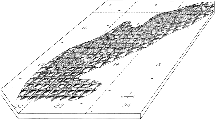
In the Madison field diagram (pl. 11) the upper and lower surfaces of the sand lens are projected to the margins of the lens, even though wells have not been drilled sufficiently near the boundaries to establish the exact thickness and position of the sand there. The vertical solid lines at the intersections of the sand sections represent wells, and the dashed vertical lines indicate locations where no wells have been drilled; the sand shown at these latter localities is therefore speculative. Where dry holes have been drilled near the margin of the sand lens, such as at several locations in secs. 12 and 14 along the eastern margin, the position of the edge of the sand body can be determined fairly accurately, but in localities where no wells have been drilled close to the margin the interpretation shown on Plate 11 is, of course, less dependable. However, there are a sufficient number of wells that record a convergence of the sand body toward the margins to indicate within reasonable limits the approximate position of the boundaries of the sand lens.
The sand body of the Madison field has an easterly-trending prong near its southern end that gives it an unusual shape. The position and limits of the prong of sand are controlled by numerous wells and the extent of the sand is limited on the east by the dry hole in the SW SE SE sec. 14 that logged only a thin sand. Some geologists believe that the sand body is probably continuous across the area immediately north of the prong, where the margin of the main sand body, as shown on Plate 11, forms a deep embayment. However, the well drilled in the NW SE SW sec. 14 had only a very thin bed of sand and produced only eight barrels of oil a day; this, together with the thinning of the sand toward this area shown by other wells, is probably the reason no test well has been drilled in this embayment. None of the dry holes shown on Plate 11, that are some distance from the oil pool, reported any appreciable thickness of sand at the horizon of the producing sand.
The Sand Body of the De Malorie-Souder Oil Field
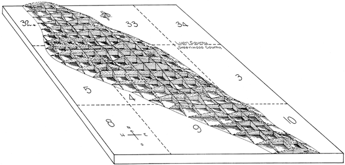
The study of the producing sand body of the De Malorie-Souder field in the Quincy trend was made by a method similar to that used for the Madison field; numerous cross sections, based on well log correlations, were made along courses approximately at right angles to the longer axis of the field. Many of these cross sections, like those made in the Burkett and Madison fields, showed the upper and lower surfaces of the sand body to be somewhat irregular, but the prevailing shape found was a convex top and an almost straight line base that had an initial slope southwestward at a low angle. Therefore, in the block diagram of the sand body of the De Malorie-Souder field (pl. 12) the base of the sand is interpreted as resting on a horizontal plane. In some well logs, sandy shale is recorded overlying the main sand body but it is not shown in the diagram, because it appears to be equivalent to shale in most localities in the field and if shown would obscure many other features.
Plate 12--Block diagram of the producing sand in the DeMalorie-Souder oil field, T. 22 S., Rs. 10 and 11 E., Greenwood County. Horizontal scale, wells spaced 660 feet apart. Vertical scale, sand in well 3, NW SE NW sec. 12 (near middle of field) is 100 feet thick. Both horizontal and vertical scales decrease progressively toward background. Data from drillers' logs. Only sandstone is shown; sandy shale omitted. Explanation same as in Plate 10. An Acrobat PDF version of this image is available.
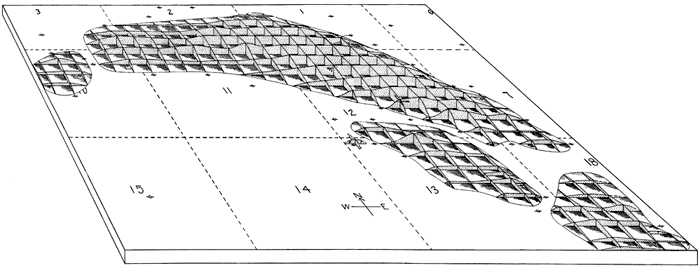
This field is more completely developed than several others in this region; most of the regular locations have been drilled, even those that lie very near the margin of the sand lens and found only a thin bed of sand. The margins of the sand body are defined by more wells in this field than in other fields of the region. Dry holes that lie just outside of the margin and that recorded "no sand," and others that are located just inside and recorded a very thin sand, have been drilled along the north border of the field at relatively short intervals from the northeast corner of the NW sec. 18, T. 22 S., R. 11 E., to the northeast corner of the NW sec. 10, T. 22 S., R. 10 E. Likewise, the position of the south margin of the sand lens is controlled by numerous wells having thin sand and dry holes that found no sand. Regular well locations that are believed to lie within the margins of the sand body but have not been drilled as yet are shown on the diagram by dashed vertical lines at the intersection of the cross sections. The NE sec. 11 and the NW sec. 12, T. 22 S., R. 10 E., constitute an undrilled area that probably contains sand, but some oil from at least the northern part of this area probably has been drained by nearby producing wells.
A narrow channel-shaped area extending southeastward through the S2 sec. 12, NE sec. 13, and the NW sec. 18, in which the logs of numerous wells indicate that no sand is present, is a rather unique feature for the sand bodies of the region. Thick sand occurs on both sides of the narrow area that contains no sand. The narrowness of the area devoid of sand, and the trend of the southwest margin of the main sand body in sec. 11 and of the smaller sand body in sec. 13 suggest that originally the sand beds were continuous across the narrow area that contains no sand. If such were true, it may be that following deposition and prior to burial of a large sand body in the area, a narrow channel was eroded across the sand body, and the channel was later filled with muds. It is perhaps equally as reasonable, on the basis of the facts at hand, to conclude that the sand bodies shown on the diagram were deposited originally as separate lenses.
Two dry holes, in the NE SE sec. 13, found no sand at the horizon of the producing sand of the oil field, which suggests that another channel may extend northeasterly through the NE SE sec. 13 into sec. 18. The extreme thinness of the sand as recorded in the logs of wells in the SW SW sec. 7 indicate that this area may be a part of a channel-like feature. Near the western end of the field a narrow area that contains no sand crosses the trend of the main sand body in the NE sec. 10. The occurrence of this area containing no sand at the extremity of a large sand body, such as that of the De Malorie-Souder field, suggests that it may have originated as a tidal inlet, similar to those on our modern coasts. The small circular-shaped sand body in the NW sec. 10 may have been separated from the main sand body originally. It is bounded on the north, east and west by dry holes that found only a thin zone of sand or no sand at the horizon of the producing beds, but future drilling may establish a prolongation of the sand body to the west.
The Sand Body of the Browning Oil Field
Numerous cross sections made from well log correlations in the Browning oil field in secs. 17, 18, 19, 20, 29, 30, and 31, T. 22 S., R. 10 E., gave somewhat confusing results. Many of the wells in this field were not drilled entirely through the sand body because the lower part of it contains water. This fact and the fact that some well logs appear to have been somewhat carelessly recorded cast some doubt on the results of the studies in this field. After studying cross sections drawn through nearly every row of wells across the fields, I concluded that, although the sections show more irregularities than are common to some of the other fields, the sand body is similar in shape to that of the Burkett, Madison, and De Malorie-Souder fields--namely, has an approximately plane base and a convex upper surface. The study indicated that the base of the sand had a low initial slope to the east.
A graphic picture of my interpretation of the shape of the sand body is shown on Plate 13, wherein the sand is represented as a lens-shaped body with a horizontal base and a convex upper surface. Only that part of the field that lies north of the S2 of secs. 29 and 30 is shown, because southwest of this area the sand is recorded in well logs as being extremely irregular in thickness and there was considerable confusion as to the correct location of several of the wells for which logs were available. Lack of sufficient time to investigate thoroughly these doubtful records made it expedient to eliminate this part of the field from the diagram shown on Plate 13. The irregularity of the diagram in the eastern part of the NE sec. 30 is caused by the drilling of five wells at regularly spaced intervals in a distance of half a mile along the east line of sec. 30, and by the drilling of only four wells at regularly spaced intervals offsetting these on the west. Similar irregularities are shown in the southernmost part of the SW sec. 20.
Plate 13--Block diagram of the producing sand in the Browning oil field, T. 22 S., R. 10 E., Greenwood County. Scale, regularly spaced wells 660 feet apart. Vertical scale indicated by well 5 in middle foreground, SW corner sec. 29, in which sand is 55 feet thick, and by well 3 in SW SE SE sec. 18, in which sand is 50 feet thick. Explanation same as in Plate 10.
Because the well logs indicate wide variations in the thickness of the sand in parts of this field, little confidence can be placed in the representation shown on Plate 13 outside the closely drilled area; for instance, the representation of the sand in the south-central part of sec. 19 and in the NE sec. 30, in the westernmost part of the diagram, is highly speculative. Dry holes in the NE sec. 19 furnish more adequate control for the representation there. It is suggested, however, that dry holes, such as the one in the northeast corner of the NW NE sec. 19 that shows a thick body of sand, probably represent incorrectly the actual conditions; it is likely that the sand contains considerable shale and should be classified, in part at least, as sandy shale rather than sand. The eastern and northeastern margins of the sand body are controlled by data furnished by several dry holes, and so greater confidence is placed in the interpretation in this part of the field. Throughout much of this field wells have been drilled on "five spot" locations, commonly in the center of a 40-acre legal land subdivision--that is, in the center of the squares formed by the alignments of the regular locations. The "five spot" wells are not shown on Plate 13, because their inclusion would add but little to the information and would obscure many features that are shown.
The Sand Body of the Fankhouser Oil Field
A graphic interpretation of the shape of the producing sand body of the Fankhouser oil field in Tps. 21 and 22 S., R. 12 E., is shown in perspective on Plate 14. It was drawn after numerous cross sections, made by the correlation of plotted well log graphs, indicated that the sand body is shaped approximately as shown. The study indicated that the base of the sand body was deposited on a plane surface that slopes to the southwest; the degree of slope is greater than in most other fields, except the Lamont field which lies adjacent to the Fankhouser field on the southeast. As shown on Plate 14, the sand body is irregular in thickness, except along the middle of the field where the sand is thickest. It probably is even more irregular than shown in the diagram, because in areas such as the SE sec. 32, the NE sec. 5, and the SW sec. 4, that contain but few wells, the representation of the sand body is necessarily hypothetical. The largest production of oil was obtained from wells in the central part of the field where the thick sand occurs.
Plate 14--Block diagram of the producing sand in the Fankhouser oil field, Tps. 21 and 22 S., R. 12 E., Greenwood and Lyon counties. Horizontal scale: distance between wells, 660 feet. Vertical scale indicated by sand in well 2 in south end of block where it is 50 feet thick. Both scales decrease progressively toward background. Explanation same as in Plate 10.
Sand Bodies of Other Oil Fields
Series of cross sections were made of the producing sand bodies in the Thrall oil field in T. 23 S., R. 10 E., the Atyeo oil field in T. 21 S., Rs. 9 and 10 E., and T. 22 S., R. 10 E., and the Haverhill field in T. 27 S., R. 5 E. The conclusions drawn from the study of the cross sections of each one of these fields were similar to those made for the Burkett, De Malorie-Souder, and other fields described--namely, that the sand bodies have approximately horizontal bases and convex tops, the sand bodies are thickest in the central parts of the fields, and the lowermost part of the sand is most widespread. In the case of the Atyeo field these conclusions were drawn from somewhat meager data; all of the well logs of the field were not available and so a relatively few complete cross sections were made. Furthermore, this field is very narrow and small irregularities in log records were in many cases of greater magnitude than the differences in the stratigraphic position of the sand as recorded in the logs. Consequently, less confidence can be placed in the conclusions reached for this field than for the other fields where the data are more complete. The sand body in the Haverhill field is also very narrow, but carefully recorded well logs were available for this field and so the conclusions drawn are supported by sufficient evidence.
Physical Character of the Sand
A few chunks (large shot fragments), core samples, and a relatively small number of sets of drill cuttings of the shoestring sand bodies were studied. The sets of samples were selected so as to obtain data on most localities in the shoestring sand region of northern Greenwood County. Written reports made by oil company geologists, based on microscopic examinations of drill cuttings from 200 or more wells in the region, were studied. Detailed facts, conclusions, and generalizations concerning the character of the producing sand, such as composition, grain sizes, stratigraphic distribution of grain sizes, and porosity, were discussed with numerous geologists and operators who had become familiar with the region through many years of experience. Eight chunk samples from cores of the producing sand were analyzed as to composition, cementing material, density, porosity, and grain size by P. G. Nutting in the laboratory of the United States Geological Survey in Washington. About two dozen thin sections of sand samples were studied. I made several analyses of the grain sizes of chunk samples of Pennsylvanian sands of Missouri that I obtained from the outcrop. A short time prior to the completion of this report the thin sections of sand from this region and those of the Missouri sands were studied by Constance Leatherock, in connection with the study of the Bartlesville and Burbank sands of Osage County, Oklahoma, and some of her findings have been incorporated in this report (Bass et al., 1936).
The sand bodies of the shoestring sand oil fields of the Greenwood-Butler County region range in thickness up to a little more than 100 feet; probably the most common thickness for the central part of each field is about 50 feet. However, the sand body of the Seeley oil field in Tps. 22 and 23 S., R. 11 E., is as great as 90 feet thick in parts of the field, and the sand bodies of the De Malorie-Souder and Madison oil fields in T. 22 S., Rs. 10 and 11 E., are more than 100 feet thick in parts of these fields. Cores of the oil-producing sand show that it is not everywhere a solid body of sand, but consists of thick beds of sand separated by much thinner beds of thinly laminated sandy shale, sandy carbonaceous shale, and shale. Walter W. Larsh, geologist, and L. L. Bechtel, production superintendent, witnessed the taking of cores of the sand in four wells by the Carter Oil Co., on its Ellis lease in sec. 27, T. 23 S., R. 11 E., in the Edwards Extension field, and reported that the sand body consisted of beds of sand several feet thick, separated by shale beds ranging from an inch to 5 or 6 inches thick, and thinly laminated shale and carbonaceous shale in beds ranging from a few inches up to half a foot thick; that the lowermost few inches of the sand contained well-rounded pebbles of black and brown chert, ranging from one eighth to half an inch or more in diameter, enmeshed in fine sand. Parts of one of these cores containing the chert pebbles and fine sand representative of the main part of the sand body and some of the thinly laminated sandy shale, shale, carbonaceous material, and sand were studied by me. The several types of material in the core are well segregated, suggesting that the sediments were well sorted by the depositional agent.
As a rule, a sand body contains more partings near the margin of the field than in the central part. In the Fankhouser field in Tps. 21 and 22 S., R. 12 E., only a narrow strip of country down the middle of the field is underlain by a fairly thick body of sand; the oil-producing sand in most parts of this field occurs in fairly thin beds of sand interbedded with sandy shale and shale. The sand body of the Wick field in T. 22 S., R. 11 E., is irregular in occurrence; the logs of some wells record all but a few of the beds that occupy the horizon of the sand body as sandy shale, and others record two bodies of sand 10 to 40 feet thick separated by shale from 10 to 50 feet thick.
Drillers, geologists, and others connected with the field operations reported that the sand in the De Malorie-Souder field in T. 22 S., Rs. 10 and 11 E., occurs in layers of coarse and very fine sand, the layers of coarse sand being largely confined to the lower part of the sand body; a similar arrangement of coarse and fine sand is reported to occur in the Shambaugh field in T. 23 S., R. 13 E., and in the Lamont field in T. 22 S., Rs. 12 and 13 E. The sand bodies of some fields, such as the Burkett field in T. 23 S., R. 10 E., and the Madison field in T. 22 S., R. 11 E., have fewer "breaks" of shale and sandy shale than others; recently cores of the lower 25 feet of the sand taken in the central part of the Madison field showed very little variation in the character of the sand; one zone, 2 feet or so thick, that contained a larger content of silt than the adjacent beds was the chief variation noted. Study of a core of the lower 25 feet of the sand in the Empire Oil & Refining Co.'s From No. 7 well in sec. 14, T. 22 S., R. 11 E., in the Madison field, shows that the sand is remarkably uniform in grain size throughout most of the 25 feet examined. A series of sieve analyses made by Nutting of samples from the core indicate that the lower part of the sand contains only slightly coarser sand grains than most of the remainder. The core contains chert pebbles up to half an inch in diameter in the lowermost few inches, however. The sand body rests on gray clay shale.
A dense unit of very fine material forms a hard cap rock over the more porous parts of the sand in most, but not all, of the fields; operators report that this upper part of the sand is very hard, and drills slowly. In most of the fields the full thickness of the sand is not saturated with oil; the upper part of the sand is commonly barren. Exceptions occur, particularly in several of the small oil fields in the Quincy trend that contain coarse sand; there the entire body of sand, as a rule, is saturated with oil.
Composition
The sand of the shoestring oil fields is composed largely of grains of quartz. Feldspar, chert, and limestone comprise a fraction of one percent to a trace of the material. Constance Leatherock (Bass et al., 1936) found traces of magnetite, epidote, chlorite, glauconite, and hematite. Inspection of a chunk or core sample of the sand gives one the impression that muscovite (white mica) is a fairly abundant constituent, but when the sand is crushed and examined under a microscope and the mica grains and quartz grains counted, it is found that the mica actually comprises less than one percent of the whole. Mica is slightly more abundant in the areas such as the Madison field and elsewhere, where the sand is comparatively fine, than in the coarse sand of fields such as are found in parts of the Quincy trend between T. 25 S., R. 13 E., and T. 23 S., R. 11 E. The mica is most abundant in the thin laminae of black carbonaceous shale and sandy shale that form partings in the sand; its habit of arrangement with the flat surfaces parallel with the bedding in these thinly laminated carbonaceous shale layers probably aids the splitting of the cores along these bedding planes, and so brings to view the laminae that contain mica in abundance.
The sand is cemented largely with siderite, dolomite, and silica, and locally calcite. Silica is abundant as cementing material in the coarse sand of the Quincy field in T. 25 S., R. 13 E. In most localities the sand is so firmly cemented that the drill fails to separate it into individual grains. Examinations with a binocular microscope show that the drill cuttings are made up of small aggregates of cemented grains, rather than separate grains. The tightly cemented condition of the sand, which produces low permeability, is one of the most important reasons for shooting the wells with charges of nitroglycerin ranging from 100 to more than 200 quarts, a common practice in these fields.
Grain Size
On the whole the sand in the Teeter and Sallyards trends is composed largely of fine (1/8 to 1/4 mm) and very fine sand (1/16 to 1/8 mm); an occasional coarse (1/2 to 1 mm) grain is present in the sand, and the lowermost few inches or less of the sand bodies contains very coarse sand (1 to 2 mm) and even pebbles (2 to 4 mm). The sand contains from 15 to 30 percent silt and clay (particles less than 1/16 mm). Cores of the sand in two wells in the Madison oil field contained pebbles of chert up to half an inch in diameter in the lowermost inch of the sand body. Pebbles similar to those seen in the cores of the wells in the Madison oil field were found in the lowermost few inches of cores of the sand in the Edwards Extension field in T. 23 S., R. 11 E. The sand in some fields of the Quincy and Lamont trends is much coarser, and in others it appears to be just as fine-grained as that of the other trends. Much of the sand in the Atyeo lens, in T. 21 S., R. 10 E., falls in the grade of medium (1/4 to 1/2 mm) and coarse (NOTE: Size classification after Wentworth, 1922, p. 377-392), and a smaller part is very coarse, and some granules are present. The sand of the De Malorie-Souder field in T. 22 S., Rs. 10 and 11 E., is reported to be interbedded fine and coarse sand; most of the coarser material is in the lower part of the sand body. The sand in the main part of the Seeley field in Tps. 22 and 23 S., R. 11 E., is of very fine and fine sizes like that in the Sallyards and Teeter trends, but in the Edwards Extension field, which includes the southeastern part of the sand body of the Seeley field, a larger portion of coarse and very coarse sand is present. From the southeastern part of the Edwards Extension field on southeastward through the Hamilton, Landon, Quincy, and other fields of the Quincy trend the sand varies abruptly in size of grain; it is composed largely of medium and coarse sand in most of these fields. Microscopic examination made by me of the drill samples of the sand from the field in secs. 19 and 20, T. 25 S., R. 14 E., Woodson County, which is being developed, shows the sand there to be composed of medium and coarse, rounded and subrounded quartz grains, similar in every way to the sand near Quincy. Farther southeast in Woodson County the sand is reported to be of finer grain. However, there is some doubt as to whether the sand of these localities occurs at the exact horizon of the sand of the Quincy trend.
The sand in the Lamont trend contains more medium to coarse sand than is found in the Teeter and Sallyards trends, but much of it is similar to the sand elsewhere and is largely composed of very fine and fine sand. The sand body of the Fankhouser field, for instance, is composed mainly of fine and very fine, subangular and angular grains, but it contains scattered through it subrounded and rounded grains ranging from medium to coarse and very coarse sizes. The same features are true of the sand body of the Lamont field, except that the coarse grains are somewhat more abundant; pebbles with a maximum diameter of 4 millimeters are reported to occur in the sand body of the Lamont field. No details of actual grain sizes are available for the sand lens of the Shambaugh field, but operators reported that some coarse sand occurs in the lower part of the sand body and yields much of the oil in the field.
Shapes of Sand Grains
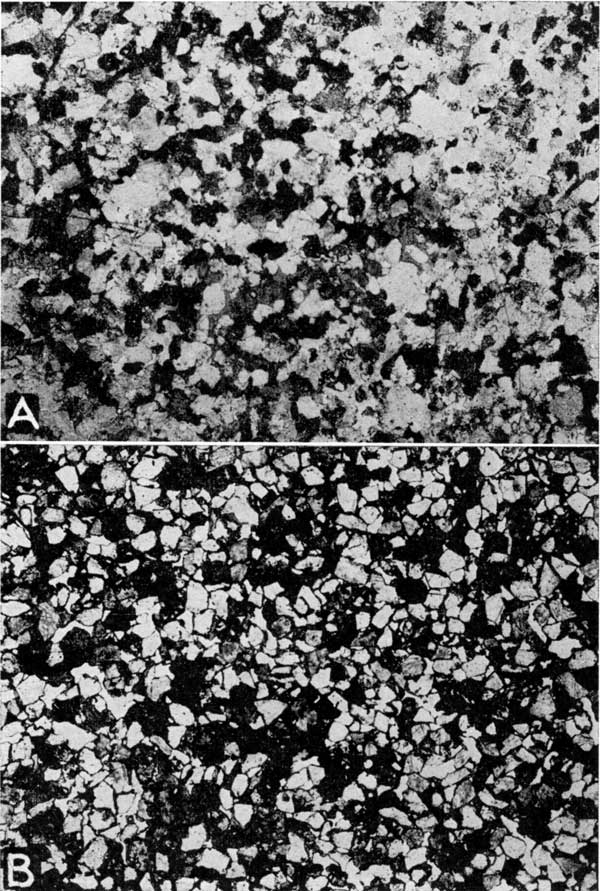
The grains of the very fine and fine sand that make up much of the sand bodies of the Teeter, Sallyards, and Lamont trends and much of the sand bodies of the northwestern part of the Quincy trend, are most commonly subangular; a lesser number are angular and a few are subrounded. (NOTE: The term angular is applied here to grains with relatively sharp edges and points; the edges of the grains are decidedly blunt in the subangular class; and the term subrounded is applied to grains on which the rounded surfaces occupy an appreciable part of the surface, and the original flat faces that are present are small; little or no parts of the original faces can be seen on the well-rounded grains). Most of the flakes of mica (muscovite and biotite) in the fine sand are ragged; many have rounded corners; none is angular throughout and a few have rounded edges. Almost all of the coarse and very coarse sand grains are subrounded or well rounded. Medium and coarse, rounded and subrounded sand grains are abundant in the Quincy trend from the region near Hamilton farther southeast into Woodson County, and in the Atyeo oil field in T. 21 S., R. 10 E. Also, most of the coarse grains found sparsely distributed in the fine sand elsewhere are well rounded. Inspection of chunk samples fails to reveal the abundance of rounded grains because of the presence of new quartz growth surrounding the grains but thin sections of cores reveal the rounded shapes of the grains. The few coarse grains of feldspar that were seen are subangular. Most of the mica flakes in the coarse sand have ragged edges. Photomicrographs of thin sections of the shoestring sands and a few photographs of other sands are shown on Plates 15, 16, and 17.
Plate 15--A, Photomicrograph of thin section of shoestring sand from Empire Oil and Refining Co.'s Kolb No. 1 well, sec. 15, T. 25 S., R. 13 E., in the Quincy trend. Magnified seventeen times natural scale. B, Photomicrograph of thin section of shoestring sand from depth of 1,924 feet in the Empire Oil and Refining Co.'s From No. 7 well in sec. 14, T. 22 S., R. 11 E., Madison oil field. Magnified seventeen times natural scale.
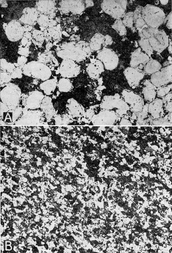
Plate 16--A, Photomicrograph of thin section of Warrensburg channel sandstone from quarry near Warrensburg, Missouri. Magnified seventeen times natural scale. B, Photomicrograph of thin section of shoestring sand from a chunk sample, containing lentils of carbonaceous material, from Gore et al., Carson 1-A well in sec. 33, T. 23 S., R. 11 E. Magnified seventeen times natural scale.
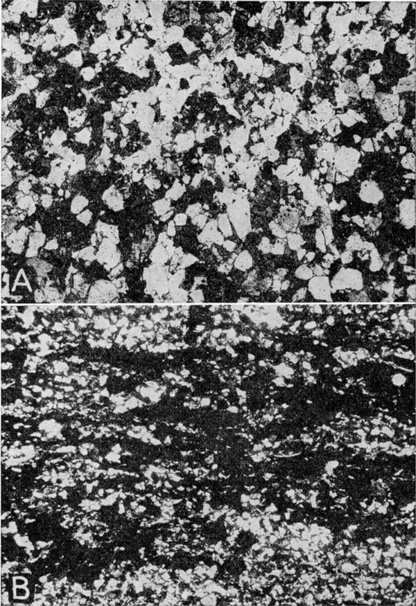
Plate 17--A, Photomicrograph of thin section of shoestring sand from a depth of 1,925 feet in Carter Oil Co.'s Ellis No. 4 well in sec. 27, T. 23 S., R. 11 E. Magnified seventeen times natural scale. B, Photomicrograph of thin section of producing sand from a depth of 3,268 feet in Barnsdall Oil Co.'s Johnson 1-A well in the SE, sec. 20, T. 33 S., R. 3 E., Rainbow Bend oil field. Magnified seventeen times natural scale.
The thin sections of sand from the Madison oil field in T. 22 S., R. 11 E., and the Edwards Extension oil field in T. 23 S., R. 11 E., were compared with thin sections of the sand of the Rainbow Bend oil field in T. 33 S., R. 3 E., in western Cowley County, Kansas, and with thin sections of the Warrensburg channel sandstone from near Warrensburg, Missouri. This examination showed that the grains of the oil sands from the Madison and Edwards Extension oil fields are not so angular as those of the sand of the Rainbow Bend field or those of the Warrensburg sandstone. The grains of the Warrensburg sandstone are the most angular of the three, and the difference between the angularity of its grains and those of the sand of the Madison oil field is pronounced.
Different Methods of Forming Sand Bodies
The origin of the shoestring sand deposits of Kansas in Pennsylvanian time are determinable only from the features of the sand bodies and the associated rocks that are revealed by the records of drill holes and a few samples of the sand. These features include extent, size, shape and distribution of the bodies, character, composition and distribution of the sand grains; types of crossbedding; and a few other facts. The method of origin of these ancient sand bodies might be revealed by comparison of their features with those of modern sand deposits.
The shoestring sand deposits necessarily represent some type of very narrow elongated bodies. Only filled stream valleys and some type of shore feature, such as offshore bars or other types of bars, appear to fill this requirement. It is true that some glacial deposits, such as kames or moraines, somewhat resemble in general shape and distribution that of offshore bars or stream channel deposits, but can be distinguished from them by the type of material of which they are composed and by evidences of glacial sediments in adjacent strata (Gilbert, 1885, p. 121); no evidence of glacial deposits is recorded in wells anywhere in the region, and none is apparent where the strata crop out in the southeastern part of Kansas and the western part of Missouri, and in Oklahoma. A glacial origin is accordingly dismissed from further consideration.
The shallow nearshore waters of our present marine water bodies and some of the large freshwater lakes are bordered by narrow bodies of sand elongated parallel with the shore, but lying a short distance basinward. These are known as offshore bars, or barrier beaches. According to students of shore processes (Johnson, 1919, p. 365-367; Gilbert, 1885, p. 87-90; Shaler, 1896, p. 151-152), these bars are formed by the following method. Briefly, as large storm waves approach shore, and therefore approach a shallowing bottom, the lower part of the wave brushes and scours the bottom, carrying forward the sediments that lie there. The forward movement of the wave is retarded, however, by the friction of its lower part with the sea bottom; the upper part of the wave continues its rapid movement forward; the water appears to pile up, and then the wave structure collapses and drops its load of sediment--the collapsing wave is known as a breaker--the forward movement ceases and the water returns seaward down the slope, forming a current known as the undertow. This returning current carries with it much of the finer sediment that was carried forward by the wave and dropped at the point of collapse. The action of the larger waves excavates a marine cliff in the sea bottom at the line of breakers and deposits debris on the bench just above the cliff, which in many parts of the coast is a mile or more from shore. Continued excavation and deposition builds a ridge of debris on the ocean bottom parallel with, but some distance removed from, the shore. In time the ridge is built above the water level and it appears as a series of small islands of sand, called offshore bars, aligned parallel with the shore. The water body that lies between the newly formed island chain and the land is called a lagoon. Between the islands, waterways, known as tidal inlets, connect the lagoon with the open sea.
The waves that beat against the offshore bars rarely strike perpendicularly; most of them, generated by the wind, strike at an angle, and the current as it returns seaward is deflected along the bar and therefore sets up a current known as the longshore current, which runs parallel with the trend of the bars. The incoming waves erode material from the seaward slope of the bars and it is transported along the face of the bars by the longshore current, filling in the low places and lengthening the bars. Gradually the islands are connected and the number of tidal inlets is reduced. The closing of inlets concentrates the flow of the tidal waters in the few inlets that remain open, and thereby increases the speed of the currents through them. These currents form deeply excavated channels. There is a constant conflict between the attempt of the longshore current to fill the inlets with sediment and the tidal currents to keep them open.
Bars that are very similar to those described above, and for our purposes here need not be separated from them, spring from the mainland, which is exposed to the direct attack of the waves, and are classified as spits. Examples are Sandy Hook, north of Long Branch, N.J., and the bars on the north tip of Cape Cod, described by Davis (1909, p. 707-712). There the material for the building of the spits is derived from the mainland by the direct attack of the waves and is transported along shore by the longshore currents.
Offshore bars are commonly characterized by their narrow elongated lenslike form; in cross section they have relatively plane-like lower surfaces and convex upper surfaces; the individual lenses may be arranged en echelon. They should be enclosed within strata that exhibit uniform bedding, which is characteristic of sediments deposited in still bodies of water. The sand in offshore bars should be in part irregularly crossbedded, due to deposition by conflicting currents and waves. The sand grains in offshore bars are characteristically well sorted and largely devoid of silt and clay. Offshore bars are transitory structures and are probably preserved only rarely.
Streams, because of their strong currents during flood periods, are more likely to deposit a more heterogeneous mass of material than that which is spread by ocean waves and currents; the stream deposit may be characterized by lenses of coarse and fine sediments, commonly crossbedded; the slopes of the crossbedded layers are steep and tend to slope in one direction (Barrell, 1912, p. 432). If the stream deposits merely fill the stream channel, the resulting sandstone will be a cast of the stream valley; its areal distribution will form a narrow, elongated, continuous, somewhat meandering pattern, and it will have a valley shape in cross section--that is, the base of the sand body will be convex downward. The Verden channel sandstone in Oklahoma (Reed and Meland, 1924, p. 150-167), the Warrensburg and Moberly channel sandstones (Winslow, 1890, p. 18; Winslow, 1891, p. 24-25, 35-37; Winslow, 1896, p. 45-54; Marbut, 1898, p. 123, 210, 270-272, 275-276, 331-332; Hinds, 1912, p. 6, 262, 310, 312, 351, 356-358; Hinds and Greene, 1915, p. 91-106) and the Graydon channel sandstone (Shepard, 1898, p. 127-139) in Missouri, and the Red Rock channel sandstone (Miller, 1901, p. 153-161; Williams, 1905, p. 316-321; Bain, 1896, p. 394-398) and others in Iowa and the shoestring sands in Kansas (Cadman, 1927, p. 1151-1172) have been interpreted as originating in this manner.
Streams that rise in highlands commonly have steep gradients and carry large quantities of sediment during flood periods; as they approach the plains the gradients diminish somewhat abruptly, which checks the velocities of flow; the streams are unable to transport the sediments farther and so they are dropped. These sediments fill the main stream channels; then, the streams split into numerous parts called distributaries that spread the sediments fanwise outside the old main channel; the resulting deposit is known as an alluvial fan. If the process continues long enough, fans of several streams may coalesce to form a sheetlike deposit. This type of deposit is forming today bordering many of the mountain ranges in the western semiarid parts of the United States. An example of sediments originating in this manner is furnished by the sand and gravel beds of Tertiary age that cap the High Plains of western Kansas, Nebraska, Oklahoma, eastern Colorado, western Texas, and eastern New Mexico; these deposits on the High Plains are believed (Johnson, 1901) to have been formed by sediment-laden streams that flowed eastward from the Rocky Mountains and dropped and distributed the sediments on the plains, where the velocities and the transporting power of the streams were reduced. The deposits on the High Plains are characterized by extreme ranges in size of grains, lack of sorting, steep crossbedding, and discontinuous lenses of boulders, gravel, sand and silt.
The accumulation of delta deposits composed of sand and silt, such as those now being built by the Mississippi River into the Gulf of Mexico, the Nile River into the Mediterranean Sea, and other rivers, constitute important deposition on a large scale. No doubt this process was an important one during ancient geologic time. Barre1l (1912, p. 377-446) has described the characteristics of sediments formed in this manner, but they will not be reviewed here, because the extreme length of the shoestring sand deposits in contrast with their narrow widths is sufficient in itself to eliminate the possibility of their being ancient deltas. For the same reason widespread or sheet sand deposits that may have been formed by coalescing beach deposits of a receding sea or large lake need not be considered at length.
Sands that have accumulated as a result of transportation by the wind are known as eolian deposits. They are numerous and some beds are very thick. Such sands are in general comparatively widespread; the sand grains are sorted as to size and type of material, and are commonly well-rounded and frosted; crossbedding is a prominent feature and characteristically the slopes of the bedded layers are in many directions, which produces an intricate pattern, though exceptions have been reported; the crossbedded layers are sharply truncated at the top, but approach the horizontal layers below by long sweeping curves. The Navajo sandstone of Arizona and Utah, described and photographed by Gregory (1917, p. 58-59) is an example of a thick deposit of eolian sand.
Although each of these types has several features or combinations of features that are commonly characteristic of the type, it is rare that in any formation all the features are distinct. Moreover, the features that are typical of certain types of deposits are commonly associated with features that characteristically belong to other types, because it is probable that most deposits of sand have passed through more than one cycle of erosion and deposition and have therefore acquired the characteristic features of more than one environment. Sand is commonly derived from the erosion of beds of sand or sandstone; accordingly, physical characters shown by the sand grains of a given sandstone did not originate necessarily at the time of deposition of the deposit in which they now occur, but may represent features acquired at a much earlier time. Berkey (1906, p. 229-250) has shown that the St. Peter sandstone, of Ordovician age, which is so widely and evenly spread over the Mississippi Valley region, including parts of Kansas, was derived from older sandstone beds that had already passed through a long complicated sedimentary history, the effects of which had imparted certain characters, such as rounded and frosted surfaces, to the grains of sand early in Cambrian time, which have persisted throughout the later history. According to Dake (1921, p. 182, 184), at least four sandstones, including the Gunter, Roubidoux, parts of the Jefferson City, and the St. Peter, in Missouri and adjacent areas, ranging in age from Cambrian through Ordovician, are indistinguishable because they are each composed of rounded grains of quartz derived from the same sources.
If a sheet-sand deposit formed by any one of the above-described processes, at some later time became the land surface, and so was subjected to the agencies of erosion, much of it might be removed, leaving only irregular patches to be buried and preserved by later sediments. These remnants might somewhat resemble in plan the elongated sand bodies, such as filled stream channel or offshore bars. The shoestring sand bodies might be conceived as representing remnants of narrow interstream areas; and the areas between the sand trends might be conceived as representing old valleys, but an arrangement of the valleys necessary to produce the sharp angles at the junction of the Sallyards and Quincy trends, in Tps. 22 and 23 S., R. 11 E., necessitates an unreasonable conception.
Hundreds of wells drilled in the Greenwood and Butler counties region have established beyond a doubt that the oil-producing sand actually occurs in elongated lenses and is for the most part absent in the areas adjacent to the lens-shaped bodies. Also, the sand is not present as a sheet sand throughout the region, nor in any appreciable part of the region. All except two (offshore bars and stream channel fillings) of the depositional methods described above produce deposits of more or less widespread extent and can therefore be dismissed from further consideration.
Filled Stream Channels or Offshore Bars
The filling of stream channels and the deposition of offshore bars produce elongated, narrow deposits. In order to determine which of these two methods is responsible for the origin of the shoestring sands, the following features have been considered: the marine or nonmarine character of the sediments; the composition, character, and sizes of the material that makes up the sand; the shapes in cross section of the sand lenses; and the areal distribution of the sand lenses, their arrangement as a whole, and the arrangement of individual lenses with respect to adjacent lenses.
Marine or Nonmarine Sediments
Deposits formed by the filling of stream channels, known as channel sands, imply a continental environment for the sediments, although it is conceivable that stream channels might be filled with marine deposits; offshore bars most commonly are formed on the margins of oceans and seas, though they may occur on the borders of large bodies of freshwater. Modern off shore bars are most abundant in marine water bodies. Few specific data that bear on the marine or nonmarine character of the shoestring sands are available, and so tentative conclusions must be drawn from but few specific facts and from contributory data of a general nature.
It is known that the lower part of the Cherokee shale consists of uniformly bedded gray and dark gray to black shale with some thin beds of limestone and locally coal beds in southeastern Kansas and northeastern Oklahoma; its uniformity is interrupted by sand lenses, such as the shoestring sands of Greenwood and Butler counties, but the beds of shale adjacent to the sand lenses appear to be uniformly bedded. The ingredients of the sand bodies are fairly uniform in composition and size of grain. These features indicate deposition of much of the sediments in a still body of water of considerable lateral dimensions where waves were effective in distributing the sediments uniformly over the bottom.
Marine fossils have been collected on the outcrop from strata closely associated with coal beds of continental origin in the Cherokee shale near Pittsburg, Kansas (Jewett, J. M., personal communication). Several limestones in the Cherokee shale, some of which occur in contact with or separated from the sandstones by a shale bed only a few feet thick, contain many fossils which are revealed by exposures of these beds in southeastern Kansas and northeastern Oklahoma. Recent microscopic studies of core samples and well cuttings by Constance Leatherock (Bass et al., 1936, p. 7) show that limestones in the Cherokee shale contain marine fossils throughout most of Osage and Kay counties, Oklahoma.
Though hundreds of sets of drill cuttings from the shoestring sands and a relatively few sets from the horizon of the sands in localities where the sands are absent have been examined microscopically by petroleum geologists, fossils from these beds have been reported in but few localities. Tarr (1925, p. 350-351) reported finding a fusulinid in sandy shale 100 feet above the base of the Cherokee shale at the horizon of the shoestring sand in drill cuttings from a dry hole, the No. 1 Levi Higginbottom, in the center of the south line of the SW sec. 29, T. 31 S., R. 6 E., south of the Eastman oil field in Cowley County. Casing had been set 30 feet above the depth at which the fossil was found and so it is safe to conclude that the specimen could not have come from a shallower depth.
Buchanan (1925, p. 814) reported the occurrence of marine Pennsylvanian fossils from the Marland Oil Co.'s No. 1 Thiessen well drilled in the SW SE SE of sec. 22, T. 34 S., R. 2 E., in the Padgett oil field. D. C. Nufer (personal communication) states that the log of the above-mentioned well records sand at depths 3,445 to 3,455 and dark-gray shale from 3,455 to 3,468, overlying the "Mississippi lime." The fossils mentioned by Buchanan were recovered while drilling in the shale. He identified two ostracodes as Healdia sp., and one specimen of Chonetes mesolobus. The Chonetes specimen was found in a fairly large fragment of shale that may have caved from the beds above the sand, according to G. S. Buchanan (personal communication). This well is so far removed from the shoestring sand region described here that positive correlation of the strata containing the fossils cannot be made with any specific part of the Cherokee shale of the Butler-Greenwood County region. It, together with other fossils found, shows only that marine conditions prevailed in at least a part of the time during which the lower part of the Cherokee shale was being deposited in this general region.
A few occurrences of marine fossils were seen in the drill cuttings examined for this report. Several fragments of crinoid stems and other fossils were found in coarse sand in the Mathews and Rex, Lewis No. 1 well drilled in the northwest corner SE sec. 8, T. 24 S., R. 12 E., southeast of the Landon oil field in the Quincy trend; these fossil fragments were somewhat worn. A small brachiopod spine was found in well cuttings from sand at a depth of 2,710 to 2,718 feet in the Seymour No. 1 well, in sec. 6, T. 27 S., R. 8 E., in the Lucas oil field in the Sallyards trend. A marine brachiopod (identified by G. H. Girty, United States Geological Survey) was found in sand in drill cuttings from 2,465 to 2,470 feet in Marolyn Oil Co.'s Harsh No. 1 well, in the northeast corner SW sec. 33, T. 23 S., R. 8 E. A fusulinid (identified by Betty Kellett, Amerada Petroleum Corp., Wichita, Kansas), Productus spines, and other fossil fragments were found at depths of 2,406 to 2,412 feet, in cuttings of limestone and shale, believed to be in the upper part of the Cherokee shale, in the Jones-Black No. 1 well in the NE NW NE sec. 31, T. 23 S., R. 6 E. This well is very near the Nemaha granite ridge; it is on the southeast flank of the well-known Burns dome (Thomas, 1927, p. 923, 925), and is 17 miles west of the Scott oil field of the Teeter trend. Only about 80 feet of strata are believed to belong in the Cherokee shale here; therefore, the marine strata in this locality probably are younger than the shoestring sand beds.
Fragments of fossils were noted by Constance Leatherock (Bass et al., 1936, p. 7) in drill samples from shale beds in the Bartlesville and Burbank sands in half a dozen or more localities in Osage County, Oklahoma. Several petroleum geologists have stated to me recently that they remembered seeing fossils in the Cherokee shale in well cuttings from the Greenwood-Butler County region, but were unable to recall the localities of the occurrences.
Samples from wells that fail to find sand at the shoestring sand horizon are given only meager examination by local geologists, because, if no sand is present, the well is a dry hole insofar as the main objective is concerned, and there is little to be gained from devoting much time to studying the Cherokee shale in dry holes. This fact may account in part for the relatively few instances in which fossils have been reported from these beds. Moreover, Kindle (1911, p. 227-228) has shown that fossils may be absent in marine beds or parts of a series of beds, which fact does not establish them as being nonmarine.
These data indicate that the Cherokee shale represents interbedded continental and marine beds; that the shoestring sand bodies are closely associated with beds that are marine; and that the sand is known to contain marine fossils at a few localities. It is, of course, conceivable that the marine fossils found in the sand might not represent organisms that lived at the time and place of the sand deposition, because they could have been eroded from a marine formation and redeposited in the sand. However, it appears more reasonable to conclude that the fossils indicate that the sand was deposited in a marine environment.
Composition, Character, and Size of the Sand Grains
Stream-laid deposits commonly are composed of a fairly large variety of substances; the material is poorly sorted and much of it is not rounded. However, transportation over long distances tends to wear off the edges and corners of the sand grains, so that the resulting deposit may not show the characteristic angularity of grains. Stream currents are subjected to extremes in carrying capacity seasonally and during flood and drought periods. A stream does most of its work during floods. Its habit is to scour out deep holes in parts of its bed and pile up the debris in other parts. Consequently, the resulting deposits vary abruptly in composition and size of grain, vertically and laterally.
The Warrensburg, Moberly, Graydon and other channel sandstones of Pennsylvanian age in Missouri have been interpreted by Winslow (1890, p. 18; 1891, p. 24-25, 35, 37; 1896, p. 45-54), Marbut (1898, p. 158-159), Hinds and Greene (1915, p. 95-96) and Shepard (1898, p. 127-139) as stream-laid deposits. The Verden channel sandstone of southwestern Oklahoma has been interpreted as a filled stream channel by Reed and Meland (1924, p. 157-167), and, as reported by them, consists of angular fragments of red and white chert 3 to 4 millimeters in diameter, spherical, frosted grains of colorless quartz, some angular pebbles of gray and reddish shale, and fossils, the whole bound together with limy cement. The description given by these authors indicates that the Verden sandstone does not closely resemble the channel sands of Missouri or the shoestring sands of Kansas.
Comparisons were made between samples from the Warrensburg and other channel sandstones of Missouri and the shoestring sands of Kansas. A photomicrograph of the Warrensburg sandstone is shown on Plate 16, A. The channel sandstones of Missouri do not differ markedly in composition from samples of the shoestring sands of Kansas. Quartz is the chief constituent of each. Fragments of coal are fairly abundant in the Missouri sands and were not identified in the Kansas sands, but fine fragments of black carbonaceous material which were not specifically identified, but might be coal or asphalt, are fairly abundant. Taken as a whole, there is probably a greater variety of material, such as limestone, shale, feldspar and mica in abundance in the Missouri channel sands than in the Kansas shoestring sands, but all these substances occur in small amounts in the Kansas sands also.
The sands from Missouri differ in grain size, angularity of grains, and degree of sorting of grains, from the Kansas sands. The shoestring sand in all the fields in the Teeter and Sallyards trends and much of the sand of the Lamont trend and the northwestern part of the Quincy trend is composed largely of fine and very fine sand, which is finer than the sand in the Warrensburg and Moberly channel sandstones of Missouri. The sand in the Atyeo oil field of Tps. 21 and 22 S., Rs. 9 and 10 E., and that in most of the fields extending from the Edwards Extension field in T. 23 S., R. 11 E., southeastward in the Quincy trend into western Woodson County is composed of medium and coarse sand, which is coarser than much of the sand from Missouri.
The sand grains in the channel sandstones of Missouri are distinctly more angular than those in the shoestring sand. The sand grains in the shoestring bodies between the Edwards Extension oil field in T. 23 S., R. 11 E., and the west-central part of T. 25 S., R. 14 E., in the Quincy trend, and that of the Atyeo oil field in Tps. 21 and 22 S., Rs. 9 and 10 E., which are composed largely of medium and coarse sand, are subrounded and rounded (shown on pl. 15, A) and so present a decided contrast in shape with the angular grains of the Missouri sand (shown on pl. 16, A). Comparison of thin sections of the shoestring sands with thin sections of the Warrensburg and Moberly, Missouri, sandstones reveal that the grains in the shoestring sand are distinctly more uniform in size than those in the Missouri sandstones.
Chunk samples of Missouri channel sandstone from the Warrensburg and Miami quarries have crudely banded, cross-bedded layers of coaly sand and sand relatively free from coal fragments; the beds blend together and are not sharply defined. Chunks and core samples of Kansas shoestring sands show finely laminated layers of micaceous sandy shale, black carbonaceous shale, and sandstone comparatively free from mica and carbonaceous material; the boundaries between the laminae are sharply defined. Such sharp segregation of material of different specific gravity is more commonly accomplished by waves and currents in large bodies of water than by stream currents, which tend to dump the sediments in more or less of an unsorted mass.
Exposures of the Warrensburg channel sandstone near Warrensburg and at many other localities, and exposures of the Moberly channel sandstone show thick zones in the sandstone body with steeply crossbedded layers. Reed and Meland (1924, p. 157-167) state that the Verden channel sandstone of southwestern Oklahoma is crossbedded at angles of 17 to 20 degrees in all exposures that occur intermittently through a distance of 30 miles. Steeply inclined crossbedding is common in stream-laid sediments, but occurs in sediments deposited by other agencies also. The few chunks and cores of the Kansas shoestring sands observed did not have this type of crossbedding; so few samples were available, however, that little importance can be attached to the absence of these features in them. The bedding is practically horizontal in most of the core samples from the sand of the Madison and the Edwards Extension fields that were seen. Crossbedding is common in the Bluejacket sandstone, which is probably equivalent to a part of the Bartlesville sand (Snider, 1913, p. 46), at many exposures of it seen in northeastern Oklahoma and southeastern Kansas, but the type of crossbedding is not like that seen in stream-laid sediments. The crossbedding planes have maximum slopes of 15 to 20 degrees and flatten by broad, sweeping curves into slopes of one degree or less. In cross section the crossbedded layers form long, sweeping wedges, tapering toward the lower ends. There is no uniformity in the direction of the crossbedding. Parallel bedding, having slopes of less than one degree, was seen in many exposures extending for 25 to 50 feet or more along the faces of ledges. The sand in the crossbedded layers is composed of well sorted, fine and very fine quartz grains, containing less than 10 percent clay and silt. The sand is remarkably uniform in composition and physical character throughout the total thickness of the sandstone, which is as much as 70 feet in some localities. The crossbedding in the Bluejacket sandstone is similar to that in modern beach deposits and dissimilar to that of river deposits.
Shapes in Cross Section
Because stream channel and off shore bar deposits differ markedly in their shapes in cross section, it is believed that the shapes of cross sections of the shoestring sand bodies indicate which of these types of deposits is represented by them. When a stream channel is filled with sediment it imparts to the resulting deposit a valley-shaped base, and the deposit is more widespread in the upper part than in the lower part. An offshore bar is quite different from this in cross section. It is built on a comparatively plane base that slopes slightly basinward, and its top forms a low arch; the lower part of the deposit is more widespread than the upper part.
Scores of cross sections of the shoestring sand lenses based on well records, in part supplemented by cuttings, were made across the oil fields in the area in Greenwood County that was studied in detail, and others were made for the Haverhill oil field in southern Butler County and the Atyeo oil field in Lyon County, outside the area detailed. A few of these are reproduced in figure 3.
Figure 3--Cross sections of several sand bodies. The DeMalorie-Souder oil field cross section extends from the SE cor. NE NE sec. 11 to the SW cor. NE SW sec. 1, T. 22 S., R. 10 E. The upper of the two Fankhouser oil field cross sections extends from the NE cor. SW NW sec. 4, to the NE cor. of the SW NE sec. 4, T. 22 S., R. 12 E. The lower Fankhouser section extends from the NE cor. SE sec. 5, to the NW cor. NE SE sec. 4, T. 22 S., R. 12 E. The upper of the two Thrall oil field cross sections extends from the SE cor. of the SW sec. 29, to the SE cor. of the NE of sec. 32, T. 23 S., R. 10 E. The lower of the two Thrall sections extends from the SE cor. sec. 30 to the NW SE sec. 32, T. 23 S., R. 10 E.
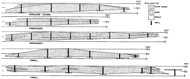
In most of the cross sections the base of the sand body approaches a plane surface; the sand body is widest at the base; it is thickest in the middle, and its upper surface is convex upward. The cross sections show also the very significant fact that the bases of the sand bodies of the Teeter and Sallyards trends when deposited had low slopes to the southeast and that the sand bodies of the Lamont and Quincy trends sloped to the southwest.
Subsurface contour maps, drawn on the top of the shoestring sands, show the upper surfaces of the sand bodies of all the fields to be convex upward; such a map of the entire region would show elongated ridges formed by the sand trends. This is illustrated by the map of the Scott oil field of the Teeter trend. It is noteworthy that the map indicates that the sand is lower on the southeast side of this field than on the northwest side, and if the regional dip of the strata, which is to the west, is removed, the eastern margin of the sand lens is seen to be even lower. This fact is additional evidence that the surface upon which the sand lens rests had an original eastward slope.
Block diagrams, on which the sand bodies are shown in perspective, have been prepared for each of several of the oil fields. The diagrams (pls. 10 to 14) show the sand to occur in lens-shaped bodies with convex upper surfaces and plane bases that had initial dips of low angles. The widest parts of the lenses are made by the lowermost part of the sand.
The Distribution of the Sand Lenses
The distribution of the sand lenses presents certain features that appear to be capable of fairly definite interpretation. Meandering courses are common features of stream channels, particularly of those streams that have reached an advanced age and are filling their channels rather than cutting or maintaining a grade. The channel of the Mississippi River, shown on the topographic sheets of the United States Geological Survey, may be used as an illustration (see fig. 4). It is marked by wide meanders throughout its course, except the lowermost part across its delta. Also, the map of an oil pool in the Majkop district in Russia, in which the oil-containing rocks have been interpreted (Maksimov, 1929, p. 813-834) as stream-laid sediments filling a stream channel, is reproduced in figure 4. The author's original map is contoured and shows the definite channel shape of the oil-bearing beds in cross section and the meandering areal pattern formed by the distribution of the sand deposit. The map is based on the records of several hundred wells.
Figure 4--Left: Sketch of Mississippi River across its delta. (After U. S. Coast and Geodetic Survey Chart 1271.) Right: Sketch of oil-producing sand in Majkop district, Russia. (Modified after M. Maksimov.)
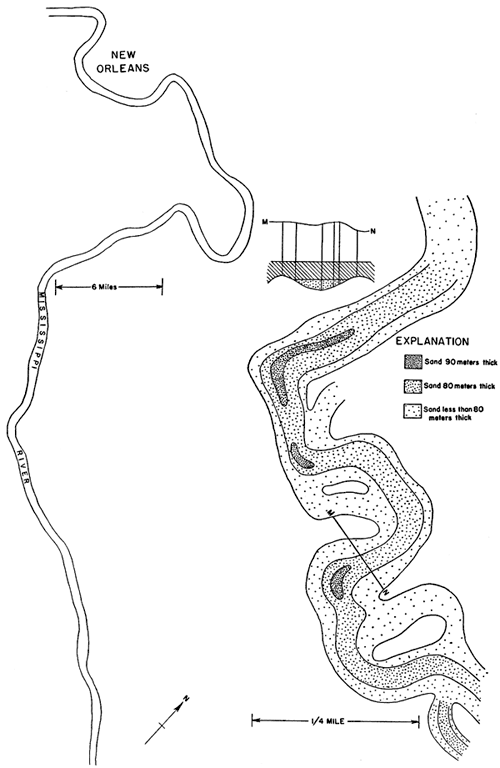
If comparisons are made of the maps of the Mississippi River and the filled stream channel of the Majkop oil district of Russia with maps showing the distribution of the shoestring sand bodies in Kansas, there appears to be much that is dissimilar. The course of the Sallyards or of the Quincy trend in Kansas is too straight to fit even the course of the Mississippi River across its delta. The meandering course of the channel sandstone of the Majkop oil field of Russia and the meandering Mississippi River channel above New Orleans are in distinct contrast with the course of each of the sand trends of Kansas. The course of the Teeter shoestring trend and that of the Lamont trend could conceivably satisfy the requirements for a stream course, such as the lower part of the Mississippi River.
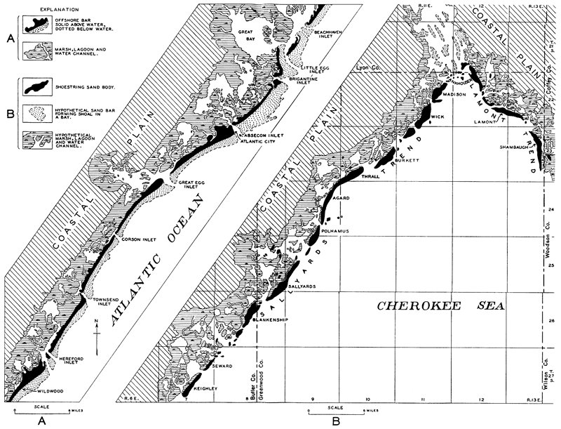
But if maps of the Kansas trends are compared with the maps of the offshore bars that border parts of our coasts, certain parallelisms are striking. A part of the New Jersey coast, which includes Atlantic City, is shown on Plate 20, copied from the United States Coast and Geodetic Survey Chart 1217. It shows the elongated offshore bars of sand, the marshes that contain numerous thoroughfares of open water and the breaks between the bars, which are called tidal inlets because they connect the ocean and the thoroughfares. On the right half of Plate 20 is a sketch of the Sallyards and Lamont shoestring trends. The sand bodies shown are definitely known from the records of the wells; much of the broad areas adjacent to the sand bodies is known, also from wells, to contain no sand of any appreciable thickness and purity; the other features, such as the marshes, ocean, thoroughfares, and shore lines, are hypothetical. Nearly all the areas shown as tidal inlets are known from the records of wells to contain no thick sand beds; they are narrow barren areas, between thick bodies of sand of the main oil fields.
Plate 20--A, Sketch of a part of the New Jersey coast. From U.S. Coast and Geodetic Survey charts 1216 and 1217. B, Hypothetical sketch of a part of the Greenwood-Butler County region during the Sallyards-Lamont stage of the Cherokee sea. (Sand bodies are known from records of wells; other features are hypothetical.)
Several features in the offshore bar system along the Atlantic coast are duplicated in the Kansas shoestring trends. Offshore bars are built largely by storm waves (Shaler, 1896, p. 151-152), but are extended by additions of sediment at their ends transported by longshore currents. The growing end of each bar tends to be offset seaward with respect to its neighbor. This offset feature is exhibited on most all parts of the Atlantic coast, but is particularly well-developed along the south shore of Long Island, shown in figure 5, where there is a westerly longshore current; the western ends of the bars are building westward. The tidal inlets between the bars are kept clean of sediments by the swift currents set up by the outgoing tides.
Figure 5--Sketch of the south shore of Long Island, New York. Stippled areas are sand bars. Arrows indicate direction of longshore currents. (After U.S. Coast and Geodetic Survey Chart 1215.)
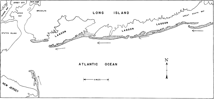
The sand bodies of the Teeter and Sallyards shoestring trends have the offset relationship of adjacent sand bodies remarkably well-developed. The offsets are accentuated if lines are drawn lengthwise down the middle of each sand body and projected somewhat beyond the boundaries of the ends. In the Sallyards trend and in the Teeter trend each sand body, with the exception of that of the Wick oil field, is offset westward with respect to its neighboring sand body on the northeast. In the Lamont trend and in part of the Quincy trend each sand body is offset to the northeast with respect to its neighboring sand body on the southeast. The series of small sand bodies in the southeastern part of the Quincy trend fail to show any development of this feature. These offset features are not found in a deposit formed by the filling of a stream channel and, as pointed out by J. L. Rich (personal communication) in his description of oil-bearing stream channel sand deposits in the easternmost part of Kansas, a stream channel deposit is a continuous body; it is not broken into segments by narrow areas devoid of sand, such as the gaps between the sand bodies in the trends of Greenwood and Butler counties.
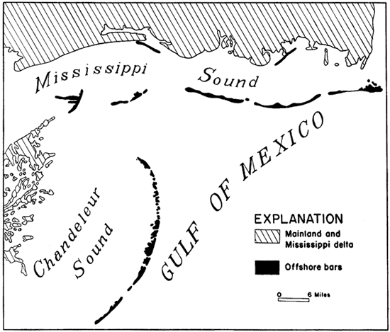
In oral discussions with several geologists, doubt has been voiced that offshore bars would form on both shores of an embayment where they approach at so sharp an angle as that formed by the junction of the Teeter trend with the Quincy trend and the junction of the Sallyards trend with the Lamont trend. A search for a similar arrangement of offshore bars along our modern coasts reveals two localities that resemble the local area. The angle formed by the trend of the offshore bars bordering Long Island and that of those bordering the New Jersey coast approaches a right angle, which is yet considerably greater than the angle of the shoestring sand trends. Also, the angle formed by the offshore bars bordering the southern coast of Mississippi and those on the eastern border of the Mississippi delta closely resembles the angle formed by the junction of the shoestring sand trends. A sketch of the offshore bars at this locality is shown in figure 6.
Figure 6--Offshore bars on the Mississippi and Louisiana coasts (after U.S. Coast and Geodetic Survey Chart 1115).
Prev Page--Structure, Development, Distribution || Next Page--Conclusions
Kansas Geological Survey, Geology
Placed on web May 3, 2011; originally published Sept. 1936.
Comments to webadmin@kgs.ku.edu
The URL for this page is http://www.kgs.ku.edu/Publications/Bulletins/23/05_lens.html