![]()
Prev Page--Tertiary || Next Page--Geologic Structure
Stratigraphy, continued
Quaternary
Sanborn Formation
The name Sanborn formation is proposed for the loess, with some gravel' and sand at the base, which is widely distributed on the divides in western Kansas, The name is intended as a substitute for the old terms "Tertiary marl" or "Plains marl" introduced for this formation by Robert Hay. The new name is derived from Sanborn, Neb., which is the nearest town to a locality of the formation in the northwestern corner of Cheyenne county, Kansas, where loess attains a thickness of 180 feet. Loess is exposed here in steep bluffs of numerous canyons on the south side of Arikaree river. Loess is underlain here by a few feet of Ogallala and by the Pierre shale.
The basal portion of the Sanborn loess is always sandy and in many cases coarse gravel was observed at the base of the formation.
Gravel. A wide distribution of coarse gravel was noticed chiefly in the northern half of Wallace County. The average diameter of the round stones of this gravel is from 1 to 6 inches, but in many localities there is in addition a considerable number of boulders some of which are 1 1/2 feet in diameter, and a few boulders have been observed that were 2 or 2 1/2 feet in diameter. (See Pls. XXXIV A and XXXIV B.) These large blocks have a more or less angular shape, but their angles are smoothly rounded, and all the surface of the blocks is smooth and shiny, though at the same time irregularly pitted, as if the surface of the blocks had been fused and smoothed by lightning. The blocks are invariably equally smooth all over their surfaces, and this smoothness can hardly be explained by repeated action of lightning, which causes only local fusion of a very small part of a rock. One could think that the evenly smooth and shiny surface of the blocks may be a result of corrosion during their transportation, but the large Pleistocene boulders of pink quartzite of northeastern Kansas, which are comparable in hardness, are only moderately smooth and never have the fusion-like polish of the western Kansas blocks just described. The cause of the exceedingly high smoothness of these blocks is therefore in doubt.
Plate XXXIV--Pleistocene gravel. A, Boulder of tough, greenish, coarse arcose with siliceous cement. From the NE SW, sec. 27, T. 12 S., R. 41 W. B, Boulder of gray to brownish cavernous arcose. From the NW NW, sec. 32, T. 12 S., R. 41 W. C, Scratched cobbles of porphyry. Two-thirds natural size. From the NW, sec. 35, T. 11 S., R. 40 W.
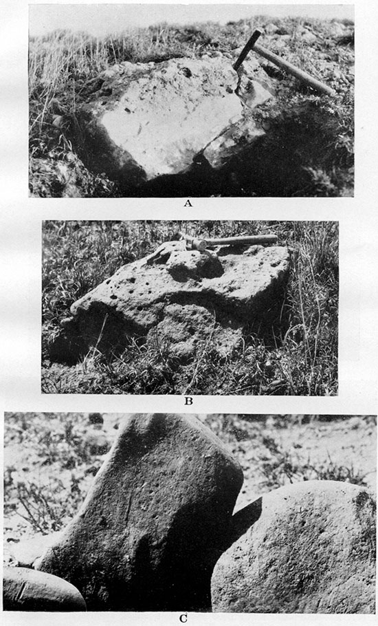
The blocks consist of medium to coarse-grained arkose cemented by secondary silica. The feldspar grains are so fresh that in thin sections they cannot be distinguished from the predominant quartz grains unless examined in polarized light. It is important to note that the siliceous cement does not entirely seal the spaces between the grains and leaves small openings in the rock. This seems to indicate that the process of cementation of the sand was interrupted and probably took place near the surface as far as it went. The pock is very tough and is not easily broken with a hammer. It is usually evenly colored gray with a slight yellowish-brown tint, which, in connection with the toughness, makes it seem like metamorphic quartzite or flint, except that the rock is always somewhat porous and cavernous. Many of the caverns have the form of straight and nearly parallel channels suggestive of molds of slender plant stems.
In many respects the blocks of arkose seem to resemble the "flint" of the South Dakota Oligocene described by Todd (Todd, 1908, pp. 87-88), who observed the scattered blocks and boulders of "flint" with "frequent casts of stems and branches of shrubs, as though this flint formed around them while in their natural position, the same as may now be observed in the siliceous waters of the National Park, in Wyoming." Todd observed only one place "where this flint stratum has been found in position," which is "the top of Cave Hills, but blocks of it are scattered very generally over the whole area, sometimes in great number" . . . and "such as are found scattered upon the top of Rabbit butte indicate that their original location was several feet higher."
No microscopic description of the "flint" is given by Todd. He assumes that the rock was formed in marshes by "a chemical deposition of flint" around the stems and branches of growing plants. If the large boulders of Wallace County belong to the same formation, the latter boulders could not possibly be of 'local origin, because no Oliogocene deposits have ever been discovered in Wallace County or in the adjacent territory of western Kansas and eastern Colorado. The nearest known Oligocene deposits are in western Nebraska more than 100 miles north and northwest of Wallace.
A few of the heaviest boulders are made of somewhat coarser arkose, which is brightly colored greenish to yellowish green and contains pink feldspars. This arkose is also cemented by secondary silica into a very tough rock. The regular round stones of the gravel are made chiefly of various kinds of igneous and metamorphic rocks, among which were recognized granite of various kinds, pegmatite, various porphyries, basalt, quartz (rock crystal, colorless, and smoky), flint, jasper, quartzite and other hard rocks. Rounded fragments of wood petrified into flint are not rare, and a . very few specimens of gray and brownish flint containing fusulinids, Productus and Spirifer, of probable Pennsylvanian age, have been collected in NW, sec. 35, T. 11 S., R. 40 W. There is hardly any doubt that all or nearly all of these rocks have been transported from the Rocky Mountains. Not a single cobble or boulder of pink quartzite, which is the most common rock in the glacial drift of northeastern Kansas, has ever been noticed in this material.
Among the medium-sized cobbles some were occasionally found with scratched surface. Almost all of these were composed of greenish-gray porphyry, a comparatively soft and thus comparatively easily scratched rock, containing scattered crystals of unaltered, nearly transparent feldspar and a few of hornblende. The phenocrysts usually project slightly above the surface of the cobbles, but many fall out and leave small cavities (Pl. XXXIV C). Occasionally short but comparatively deep and angular grooves stretch from these cavities or from broken crystals, as if the grooves had been produced by the crystals being torn under considerable pressure through the surface of the inclosing rock. The majority of the scratches are, however, faint and are visible only under strong tangential illumination. Nearly all of the scratches are short and straight or slightly curved, but some are curved pronouncedly. Only in one locality have there been found (by W. L. Russell) cobbles of another porphyry of reddish-brown color and with few, if any, phenocrysts. This is also a comparatively soft rock easily scratched with a pocket knife.
The writer noticed that pronounced weathering of many cobbles has occurred since they were deposited. This weathering is manifested by exfoliation in some cobbles, and in others by the development of irregular transverse cracks. It is interesting, also, that among the cobbles now scattered on the surface many have the so-called "desert varnish," a thin black shiny coating on the side turned up. Some of the scratched cobbles have this black coat covering both the polished surfaces and. the scratches. Other scratched cobbles have been exfoliated, and the scratches can be observed only on the remnants of the old polished surface here and there on the cobble.
The coarse gravel with scratched cobbles in it does not belong to the Ogallala formation, but is of later age. It is true that there are gravels within the Ogallala that are composed of the same rocks, the Rocky Mountains being the common source for the material of both, but the writer has never been able to observe in the undoubted beds of Ogallala gravel either the scratched cobbles or the large angular boulders of arkose. At one place he observed a few of the arkose boulders clearly above the outcropping topmost bed of Ogallala--the concentrically banded algal limestone (in the NW, sec; .2, T. 12 S., R. 40 W.). In many exposures the gravel was observed directly below loess of the divides and above the Ogallala and the Pierre. In these outcrops the upper part of the gravel is mixed with loess. The thickness of the gravel varies and hardly exceeds 15 feet at the most; it is difficult to measure exactly on the outcrops because the gravel is unconsolidated. The best way to distinguish this gravel from the gravels of the Ogallala formation is to find fragments of Ogallala rocks in the material of the later gravel. Fragments of Ogallala limestones have been found by the writer in several exposures of the gravel.
Whatever theory as to the origin of this gravel is proposed must explain the presence of scratched cobbles and heavy boulders among the material. It is apparent that no stream or flood of water could have brought it from the Rocky Mountain region, the slope of the valleys and of the prairie of the Great Plains being inclined too gently. The presence of very large boulders and of scratched cobbles suggests transportation by ice, but as no glaciers of the Pleistocene are known to have advanced over this region, it seems that river or flood ice is the only possible agency that could bring the heavy boulders, some being 2 1/2 feet in diameter. The same river ice could scratch any cobbles frozen into it against other rocky material during possible river jams comparable to those on the Mackenzie and other Arctic rivers of today.
Loess. The loess of the Pleistocene of western Kansas, which is here defined as constituting the major part of the Sanborn formation, was first recognized as a distinct stratigraphic unit and set apart from the older (Ogallala) deposits by Robert Hay. The descriptions and geologic cross sections by this author indicate clearly that the formation, which he named "Plains marl," is what we now call loess. According to Hay it overlies unconformably the "Tertiary grit" or what is now called Ogallala (see many geologic sections by Hay, 1890, and the sections on Pl. XLII, between pp. 548-549, Hay, 1895.). Hay remarks that what he calls "Tertiary marl" or "Plains marl" (a later term) "has been called loess by geologists of both Nebraska and Colorado." (Hay, 1895, p. 574). Haworth compares the "Plains marl" of Hay to loess in the following words: "In general character this is surprisingly similar to the glacial loess so well known in many parts of the world. . . It is probable that many of the properties of the plains marl are largely due to the action of wind" (Haworth, 1897, p. 275). He acknowledges, also, the frequent occurrence of the "Plains marl" above the "mortar beds" (Idem, p. 280; also Haworth, 1897a, p. 58). Darton speaks of the loess of northern Kansas mantling "a somewhat irregular surface composed of Tertiary deposits and the several Upper Cretaceous formations" (Darton, 1905, p. 166). Loess of western Kansas is treated as a separate post-Tertiary formation in the modern papers on the underground resources of Kansas (Moore and Landes, 1927, p, 32).
The loess of Wallace County, which is locally called "yellow dirt," "badger dirt," etc., covers not less than nine-tenths of the county, being found both on the divides and on the slopes and bottoms of the valleys. It seems to the writer that only the loess that covers the divides can be considered to be of Pleistocene age, the loess of the valley slopes and bottoms being largely if not wholly redeposited from the divides, the redeposition having taken place probably for the most part in late Pleistocene and Recent times. At any rate redeposition of the topographically higher loess to the lower areas is still going on, the wind and surficial waters being the chief agents of transportation.
In Wallace County the loess of the divides (Pl. XXIV B on the right and Pl. XXXV A) varies in thickness, having an average of about 20 to 40 feet, and probably does not exceed 60 feet thick. The- loess of the divides is yellowish buff, is porous, not stratified and builds perfectly vertical cliffs. All these features are typical physical properties of loess in the restricted sense, as recently set forth by G. B. Barbour (Barbour, 1927, p. 281, and Barbour, 1930, p, 463). Toward the base it becomes sandy and grades into the gravel described above. The name Sanborn formation is introduced for this loess of the divides alone, including its sandy base and the underlying gravel.
Plate XXXV--A, Sanborn formation. Typical loess with vertical cleavage resting upon Pierre shale. In the center of the NE, sec. 12, T. 13 S., R. 42 W. B, Redeposited stratified loess with slight admixture of sand and gravel. In the SE SW, sec. 12, T. 13 S., R. 42 W. C, Sandy alluvium with cross-bedding. In the channel of Goose creek, in sec. 36, T. 11 S., R. 43 W.
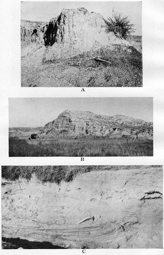
The loess of the valley slopes, which is reworked loess of the divides and must not be called Sanborn formation, attains a thickness of 50 feet, but approaches that thickness in only a few places, usually along a narrow zone high on the slopes. This loess is usually distinctly stratified (Pls. XX A and XXXV B), which is due to the interbedded layers composed of fragments of locally outcropping rocks (chiefly Ogallala) mixed with loess. The valley-bottom loess (Pl. XXXV C, upper part) is more evenly distributed and is usually 10 to 15 feet thick. It passes downward into alluvial sands and gravel, and it also must be regarded as a part of the alluvial deposits. The river loess is usually colored not as brightly yellow as the loess of the divides, but is yellowish-gray to gray, the dull tinge being apparently due to admixture of humus.
An analysis of Wallace County loess was kindly supplied to the writer by Harry C. Wheeler. The sample analyzed was taken from the basement of Mr. Wheeler's house at Sharon Springs, and the analysis was made by J. A. Stadler, chemist of the Lehigh Portland Cement Co., Iola, Kan. It is remarkable that this western Kansas loess, which so many writers hesitated to call by its proper name, is closer in chemical constitution to the loess of China, or to the loess of the type locality of this interesting rock, than all other loess-like rocks and adobe soils of Europe and North America that were many years ago compared with Chinese loess (Compare analyses in Clarke, 1924, p. 514, and Barbour, 1927, pp. 282-283).
| Analyses of loess from various localities | ||||
|---|---|---|---|---|
| Loess of Wallace County, Kansas |
Typical Chinese loess. |
"Loess soil" of Cherokee County, Kansas. |
Loess at Kansas City, Mo. |
|
| SiO2 | 63.33 | 62.22 | 69.66 | 74.46 |
| Al2O3 | 12.92 | 18.1 | 12.71 | 12.26 |
| Fe2O3 | 3.34 | 4.89 | 3.25 | |
| CaO | 5.44 | 6.31 | 1.09 | 1.69 |
| MgO | 1.96 | 2.09 | 1.28 | 1.12 |
| Na20 | .22 | 1.17 | 1.43 | |
| K2O | .99 | 2.42 | 1.83 | |
| CO2 | * | 4.10 | .49 | |
| H2O (at 110°) | .73 | 2.70 | ||
| Loss on ignition | 9.62 | 1.81 | ||
| * Included in loss on ignition. | ||||
The writer did not succeed in finding any fossils in the loess of the divides of Wallace County or the Sanborn loess of western Kansas, though in the stratified loess on valley slopes and in the grayish loess of the valley bottoms he has occasionally found bones of buffalo.
Alluvium
The valleys of Wallace County are surfaced with alluvial deposits, which ordinarily consist of sand and gravel below (Pl. XXXV C, lower part) and of more or less sandy river loess above (Pl. XXXV C, upper part). In the areas of the widest distribution of the outcrops of Ogallala, as in the basin of the south fork of Smoky Hill river, west of Wallace, or on Goose creek at about the same meridian, the alluvial sands and gravels attain in places a thickness of 40 feet. They show distinct cross-bedding (Pl. XXXV C, lower part) in the exposures and at a few places show a slight cementation with calcium carbonate, thus imitating some sands and gravels of the Ogallala.
In other areas the thickness of the alluvium rarely exceeds 20 feet, which includes the sandy river loess.
Prev Page--Tertiary || Next Page--Geologic Structure
Kansas Geological Survey, Geology
Placed on web Nov. 17, 2014; originally published April 1, 1931.
Comments to webadmin@kgs.ku.edu
The URL for this page is http://www.kgs.ku.edu/Publications/Bulletins/18/04_strat4.html