![]()
Prev Page--Upper Cretaceous Formations || Next Page--Quaternary
Stratigraphy, continued
Tertiary
Ogallala Formation
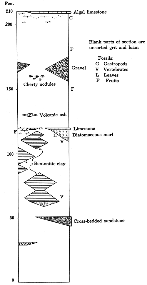
The Ogallala formation of Wallace County is usually buff' colored to pinkish and consists chiefly of unsorted sand and gravel, usually mixed in various proportions with fine dust (loess-like fine sand or silt), which makes the rocks of the formation rough to the touch. However, in some areas fine unctuous clays of pleasant light-green and reddish-brown colors constitute important beds in the lower part of the formation (Fig. 5), and in the middle and especially in the uppermost parts of it lenses and beds of white and pinkish limestone are not infrequently observed. Beds of gravel and sorted sand, some with a distinct cross-bedding, occur in places in the formation, the sands being usually colored light gray or greenish. Bluish-gray volcanic ash and light-gray to snow-white diatomaceous marl are locally found in the lower and middle parts of the Ogallala, and variously colored chert in the form of nodules and in small irregular lenses and beds is occasionally seen. Calcium carbonate is present in almost all of the Ogallala rocks. It is distributed through the rocks both as fine material and in the form of small and medium-sized nodules. Calcium carbonate in many places binds the sedimentary material of the Ogallala so firmly as to produce a series of hard ledges, interbedded with only slightly cemented beds. The hard ledges are usually unevenly cemented and form roughly weathered benches and cliffs which resemble mortar and accordingly are often referred to as "mortar beds."
Figure 5--Generalized section of Ogallala.
Typical Ogallala Beds
Darton, who proposed the term Ogallala, considers this formation "to be a stratigraphic unit and to be continuous from the type locality near Ogallala (as the geographic name from which the name of the formation is derived is spelled on all modern maps and in official communications Ogallala (not Ogalalla), this spelling has been adopted by the U. S. Geological Survey and is followed by the writer.) station in western Nebraska" across the western parts of Nebraska and Kansas to the Syracuse and Lakin quadrangles in western Kansas (Darton refers to Ogallala, also the Tertiary beds in northern New Mexico). Darton (Darton, 1920, p, 6) says: "The principal material of the Ogallala formation is sand, which differs in texture from place to place and in different beds. In most places there are at several horizons, especially toward and at the base, deposits or streaks of small gravel mixed with the sand in greater or less amount, and much of this coarser material is cemented into a loose conglomerate or coarse sandstone. Throughout the formation irregular bodies of calcium carbonate have been deposited about the sand grains and make a soft 'grit,' as it is termed. This material ranges in texture from coarse conglomerate to a fine-grained mixture of calcium carbonate and silt, often called 'magnesia.'" He also mentions "a thin bed of nearly pure limestone which caps the high summits" in the northwestern and central Syracuse quadrangle.
Darton never described the particular section of the Ogallala at the type locality of the formation, but the "section of Tertiary grit along the North Platte northwest of Ogallala, Neb.," was described by Hay, who was cognizant of the stratigraphic distinction between the "Tertiary grit" and the buff-colored "Plains marl" or loess. [Hay, 1895, pp. 569-577, 580-584. In this paper Hay states that what he calls Plains marl "has been called loess by geologists of both Nebraska and Colorado," and admits that "its formation may have been in part contemporaneous with that of the loess." (p. 574.)] The following description of Ogallala formation at the type locality is quoted from Hay (Idem., p. 580).
| Feet. | ||
|---|---|---|
| 1. | White "magnesia" limestone | 40 |
| 2. | Reddish-brown marly limestone | |
| 3. | Gravel, slightly cemented, 5 to 10 feet | |
| 4. | Rough, hard, mortar-bed grit | 25 |
| 5. | A softer layer | |
| 6. | Reddish, sandy, marly grit | |
| 7. | Pebbly grit, 3 or 4 feet | |
| 8. | White grit, weathering rough | 40 |
| 9. | Pebbly grit, a few feet | |
| 10. | Hard ledges with few pebbles | |
| 11. | Reddish clay with harder streaks, 3 feet | |
| 12. | Hard whitish bed | 35 |
| 13. | Polishing powder | |
| 14. | Limy, whitish bed | 80 |
| 15. | Hard, white rock | |
| 16. | Faint cream-colored grit | |
| 17. | Hard white rock | |
| 18. | Softer white rock, 15 feet | |
| 220 | ||
| 19. | To river bed below Tertiary grit | 240 |
"The beds run into one another so much that it is difficult to separate them. An escarpment showing 15, 16 and 17, had also a bed of gravel halfway across . . . Beds 3, 7 and 9 give the hummocky gravelly hills to the outcrop, but the interjection of gravel in No. 16 indicates that other levels may also supply gravel."
The "polishing powder" of bed No. 13 is probably volcanic ash, a deposit of such ash being observed by the writer in about the same position in the section of Ogallala two miles east of Ogallala station.
Bed 19 is not described by Hay from the outcrop, but he gives a brief record of rocks from "a boring at Paxton, Neb., 19 miles east of Ogallala," which he regards as continuing the section downward thus:
| Feet. | |
|---|---|
| Hard red clay with hard, limy streaks and sand streaks, some several feet thick | 100 |
| Similar material with hard ledges 5 or 6 inches thick | 58 |
| Hard white limestone | 10 |
| Red material with hard streaks | 80 |
| Total | 248 |
It appears justifiable not to regard this additional 248 feet of rocks as a continuation of the 200 feet of Ogallala, because the rocks do not outcrop at Ogallala town, because they are. somewhat different lithologically, and because the thickness of the formation as traced from here across southwestern Nebraska, northeastern Colorado and western Kansas is very uniform and does not seem ever to exceed 210 feet.
As far as known to the writer no fossils have ever been described or recorded from the type locality of Ogallala. It is the general character of the formation, consisting of poorly sorted, always somewhat pinkish material with the presence of prominent escarpments formed of partly cemented "mortar beds," that was commonly used for recognition. On a recent trip to the type locality the writer collected some fossils which appear to verify the correlation of the late Tertiary beds of western Kansas and northeastern Colorado with the formation exposed at Ogallala. The writer intends to publish in a separate paper a description of the lithology of the Ogallala at the type locality and the fossils collected there.
Prior to Darton's work in the Great Plains region the vertebrate paleontologists described many late Miocene and early Pliocene bones from what they customarily called the "Loup Fork" formation, a term originally applied to Pleistocene deposits in eastern Nebraska. The Loup Fork formation of Hayden, Leidy, Marsh, Cope and in part of Scott, Hatcher arid Osborn, may be regarded as corresponding to the Ogallala of Darton. To this formation, also, belongs the Republican river formation of Osborn (1910, p. 348) and part of the Snake creek formation of Cook and Matthew (1924).
The lower limit of the Ogallala in Kansas and Colorado is well defined, both lithologically and stratigraphically. Ordinarily the formation rests unconformably on various members of the Upper Cretaceous of the plains. According to observations by Darton along the south side of the North Platte valley in western Nebraska and on exposures in northeastern Colorado, Ogallala beds are unconformably underlain by sands of the Arikaree formation of Lower Miocene age. The lithology and age of the rocks that underlie the Ogallala formation at the type locality is but little known at present. These rocks, according to the description of well cuttings by R. Hay quoted above, do not correspond lithologically to the Arikaree formation of Darton.
The eroded surface of the Ogallala is usually covered with a mantle of unconsolidated gravel, sand and loess of Pleistocene and Recent age, but in places some harder young rocks are observed, the relation of which to the Ogallala formation is difficult to determine. In Meade county, Kansas, in strata that appear to be typical "mortar beds" an early Pleistocene fauna is found, but, as Darton remarks, some portions of younger deposits of the McPherson formation type "cemented by calcium carbonate might be expected to resemble the Ogallala closely." The writer observed some sands in the valley of Smoky Hill river in western Wallace County, which were richly impregnated with calcium carbonate, but which are apparently much younger than the near-by typical Ogallala "mortar beds."
Darton estimates the thickness of the Ogallala properly so called in Syracuse and Lakin quadrangles to be about 190 feet (Darton, 1920, p. 3), but he also refers to the Ogallala in a broad sense the total of about 300 feet of post-Mesozoic sediments that were penetrated in the wells of these quadrangles, because "no separation is practicable in this region" (Idem, p. 6). This "300 feet or more of beds that constitute the Ogallala formation comprise deposits elsewhere separable, even including locally in their upper part a representative of the McPherson formation ('Equus beds'}." The thickness of the "Tertiary grit" that is exposed northwest of Ogallala is estimated by Hay to be 220 feet. The writer measured the section of the outcropping beds of Ogallala formation northeast of Ogallala town and in Ash Hollow on the North Platte river, about 27 miles northwest of the town. At the first locality only 105 feet, which belongs to the upper part of the formation, is exposed. In Ash Hollow about 200 . feet, or probably the whole thickness of the formation, is exposed.
The writer found the thickness of the typical Ogallala formation of Wallace County to reach 210 feet, which corresponds closely to the estimate of the Ogallala formation in the restricted sense in' the Syracuse and Lakin quadrangles and to the estimate of the formation at the type locality. Only these beds which consist chiefly of the grit partly cemented with calcium carbonate and have a typical "mortar beds" appearance or which are paleontologically proved equivalents are referred to Ogallala in this report.
On the top of these beds there was observed a peculiar and remarkably persistent hard limestone, which was traced not only over the larger part of Wallace County but also far north, west and south in the adjacent area. This ledge of limestone is only 2 to 3 1/2 feet thick, It has an irregularly pitted surface (see Pls. XXI A and XXII A) and is made of unstratified, hard, compact, usually pinkish limestone and has a peculiar concentrically banded structure, which resembles closely that of the algae reefs and irregular pisolites of the Green River formation recently described by Bradley (Bradley, 1929). The position of the bed, always on top of the local Ogallala (Pls. XX A, XX B, XX C and XXIII A) and often at the same level over a considerable distance (especially in the south part of Wallace County), suggests that this limestone was deposited in a nearly horizontal position, no other beds like it being noticed by the writer in the local post-Mesozoic rocks. The bed is parallel to the other beds of the Ogallala (Pl. XX B) and wherever the formation has been folded, which has occurred most extensively in the west-central part of the county, the concentrically banded limestone is involved in the folding. It is quite clear from this that the bed belongs to the Ogallala and is the capping rock of the section. It is everywhere underlain by a somewhat softer, porous or spongy, cream to nearly white limestone (Pls. XX B and XX C) with a mixture of sand grains. Some parts of this white limestone are harder than the rest and contain small lenses and bands of transparent or milk-white chert. In a few exposures shells and casts of a very small fresh-water gastropod, Planorbis, were found near the top of the white limestone. The white porous limestone is usually 10 to 20 feet thick and grades downward into the ordinary grit of the Ogallala. Owing to its peculiar appearance, prominence in the exposures and definite stratigraphic position the pink concentrically banded limestone makes an especially important key bed for structural mapping of the Tertiary.
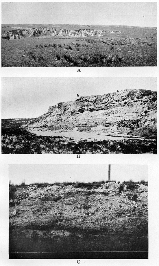
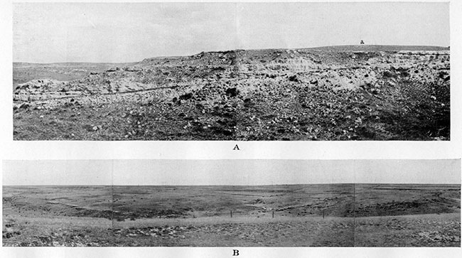
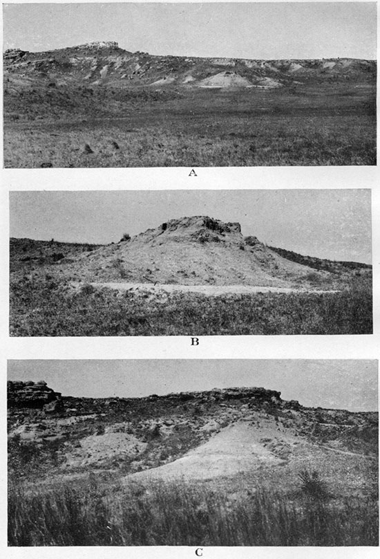
Plate XX--A, Bench of upper Ogallala grit capped with algal (Chlorellopsis) limestone shown on the skyline. Below are steep cliffs of stratified redeposited loess with cobbles of algal limestone. In the SE SE, sec. 29, T. 15 S. R. 39 W. B, Upper part of Ogallala with capping algal (Chlorellopsis) limestone marked a. Shows perfectly parallel stratification of all beds of the section, including the algal limestone. On north side of south fork of Smoky Hill river half a mile west of Kansas-Colorado state line. C, Algal (Chlorellopsis) limestone on the top of exposure. Shows sharp but somewhat irregular contact of the limestone with underlying calcareous loam, a softer and darker rock distinctly but somewhat irregularly stratified. In railroad excavation three miles east of Kanorado, Sherman County, Kansas.
The pink concentrically banded limestone usually does not outcrop as a solid ledge, but is broken into irregularly oval or angular and somewhat flattened cobbles a few inches to a foot or more in horizontal diameter (Pl. XX C, also Pl. XXXIX B) . The texture of the bed may be called irregularly pisolitic, the limestone being traversed by a very fine more or less concentric rhythmic banding (Pls. XXI A and XXI B). The fine banding presents an alternation of creamy, light-brown, brick-red and otherwise shaded reddish-brown irregularly concentric bands, the cores of which and the matrix between the irregularly oval "ovulites" are usually colored in nearly uniform light creamy or pinkish shades. The rock is usually full of scattered grains of colorless quartz and pink feldspar, the size of which ranges from tens of microns to a few millimeters. Very rarely much larger pebbles of quartz are observed in the rock. Some of the sand grains are found in the center of the smaller and more regular pisolitic "ovulites," but the vast majority of these grains have no relation to the banding at all and are scattered uniformly through the rock. Many of the larger loops of banding embrace groups of smaller concentric structures. A few fragments, also, with nearly parallel banding have an enveloping crust of fine concentric banding. This and. other examples of interrupted and resumed growth are fairly frequent. The thin section reveals a cryptocrystalline structure, the banding of which is due to the zonal arrangement of nearly opaque calcium carbonate, a little more crystallized and more transparent buff-colored bands of the same substance and occasionally still more transparent layers of the same carbonate with a faint radial (transverse) structure. The first two kinds of bands are not sharply separated, the nearly opaque substance presenting lobate and digitate outgrowths into the lighter bands. Locally there are much thinner and closer spaced brick-red bands of iron oxide and buff-colored calcium carbonate. In the broader bands may be noticed a few small spherical bodies with comparatively thin outer zone made of a mosaic of comparatively coarse-grained colorless calcite, much like the walls of the hollow spheres representing the individual cells of Chlorellopsis coloniata Reis, the microscopic alga of the Green River formation reefs (compare p. 207 and Pl. 32-A, Bradley, 1929). Some of the spherical bodies from the Ogallala rock are hollow also. The more important difference between the spheres from the limestones of the two formations is the smaller diameter of the spheres from Ogallala. The measured diameter of seven spheres from the Ogallala is as follows (in microns): 85, 63, 65, 75, 97, 63, 62, whereas the diameter of the spheres of Chlorellopsis coloniata Reis ranges from 110 to 140 microns in the Miocene algal reefs of the Rhine valley in Germany (Reis, 1923, pp. 107-109; translated and quoted by Bradley, 1929, p. 207) and from 103 to 122 microns in the Green River Eocene of Wyomingy Colorado and Utah (Bradley, 1929, p. 207). It appears as if the spherical bodies from the concentrically banded limestone of the Wallace County Ogallala, which is of Lower Pliocene age, if correctly interpreted as individual cells of an alga, belong to a different species of Chlorellopsis.
Plate XXI--A, Algal (Chlorellopsis) limestone outcrop showing weathered surface of the reef with occasional embedded cobbles of same limestone. In the NE sec. 3, T. 12 S., R. 40 W. B, Algal (Chlorellopsis) limestone. Polished section.
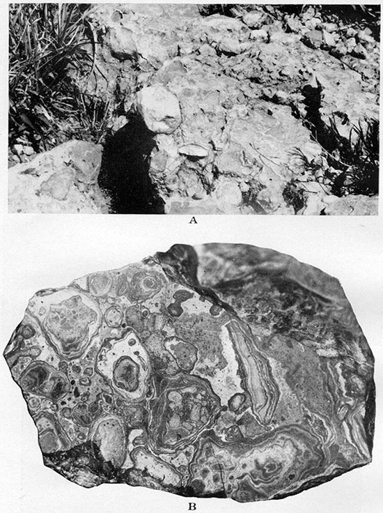
Plate XXII--A, Algal (Chlorellopsis) limestone. Upper surface of a boulder with etching produced by the roots of living grasses and other herbs, four-tenths natural size. In the NE sec. 3, T. 12 S., R. 40 W. B, Algal (Chlorellopsis) limestone. Lower surface of a boulder covered with small dripstones, three-tenths natural size. Same specimen as A.
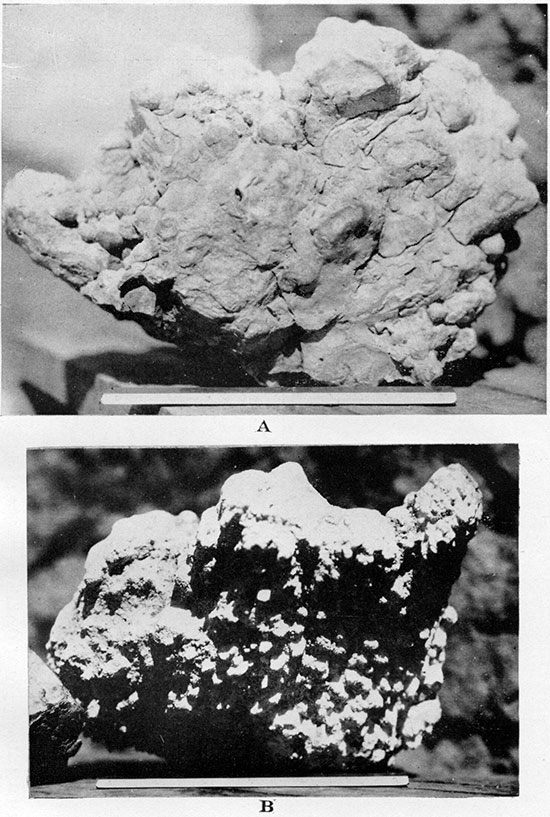
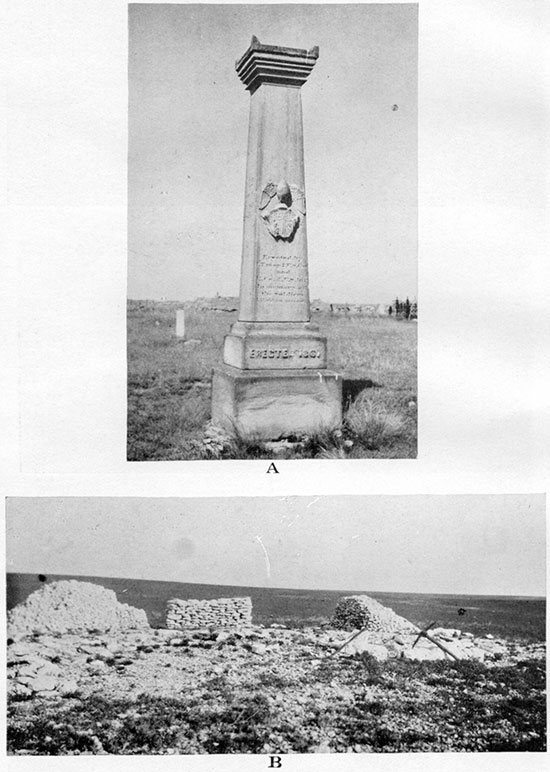
Plate XXXIX--A, Memorial monument made of Niobrara chalk, erected in 1867 at Fort Wallace. B, Small quarry opened in algal (Chlorellopsis) limestone of Ogallala. Shows comparatively small size and somewhat irregular shape of slabs into which the limestone weathers in the exposures.
After the above notes were written the writer received the following account of an examination of this algal limestone by W. H. Bradley, to whom the writer sent two samples of the rock:
"The sections of the deposits from the Ogallala formation from Wallace County, Kansas, and from sec. 7, T. 25 S., R. 42 W., Hamilton County, Kansas, are so nearly alike that they can be discussed together. In general all parts of these reefs appear to have been more extensively recrystallized than many others that I had available for study from the Green River formation. Nevertheless, I agree with you that a large part of these deposits was apparently formed by an organism much like Chlorellopsis. The cells are indeed smaller than the species which I described and probably should be referred to a different species. They show a similar habit of growth in roughly concentric layers much the same as those that I described. Many of them, however, especially those detached from the areas showing systematic growth layers are enlarged by external coatings. I think your interpretation of these enlarged cells is probably right, namely, that it is an inorganic incrustation perhaps quite independent of the original algal cell. This seems the more probable because associated with the parts of the reef showing definite algal structure are undoubted oolites. Some of the Chlorellopsis cells apparently have been flattened during the compaction of the deposits. So far as I recall, I did not observe that in the Green River reefs. In addition to the layered Chlorellopsis structure there is apparently some algal deposit like that which I called, for the want of a better name, the spongy structure."
"The oolites associated with the algal deposits in these reefs are of quite various sizes. Their nuclei are of irregular particles of clay or marl. These oolites usually show concentric growth, but a few consist of radial fibrous crystals. Areas of these oolites, however, are usually mixed with more or less clastic material and are rather easily distinguished from areas built up by systematic growth of algre." [From personal letter Jan. 16, 1931, to the writer.]
In view of this confirmation of his opinion the writer feels justified in distinguishing the Chlorellopsis of the Ogallala limestone, the cells of which are distinctly smaller than those of C. coloniata, by giving this alga a name. He proposes to call it Chlorellopsis bradleyi after W. H. Bradley. The diameter of the spherical cells of this species is usually 62 to 65 microns, but it is often larger, reaching nearly 100 microns.
Plate XXIII--A, Upper part of Ogallala in the cut of abandoned road on the line between secs. 12 and 7, T. 14 S., Rs. 39 and 38 W., looking east. Compare diagrammatic columnar view of the section on Plate XXXII-2. Algal (Chlorellopsis) limestone marked a. B, Syncline in Ogallala with axis running southwest and across a large intermittent unnamed creek. In the SE, NE, sec. 6, T. 13 S., R. 41 IV., looking southwest. Shows mantle of loess completely covering Ogallala beds and forming gently rolling prairie in the distance.
The rhythmic banding similar to that of the Ogallala limestone is interpreted by many authors as due to a chemical precipitation of calcium carbonate (Linck, 1903; Schade, 1909 and 1910; Bucher, 1918; see, also, Grabau, 1913, pp. 886-388, and Twenhofel, 1926, pp. 539-543) or to the action of bacteria (Vaughan, 1914, pp. 49-54). It is quite possible that either of these two factors, or both of them, played a part in the deposition of the Ogallala concentrically banded limestone. This, however, would not exclude the algal precipitation of the other part. In fact the texture of the Ogallala limestone resembles most closely those specimens from the Green River formation that are interpreted by Bradley as compound reef with "alternating zones of algal and inorganic limestone (see Bradley, 1928, Pls. 43-46, especially Pl. 44A and Pl. 46B). It appears to the writer that the thinner bands of calcium carbonate and iron oxide, deposited around the nuclei of quartz and feldspar and producing more or less regular small-sized ovulites scattered through the Ogallala limestone, are most probably due to inorganic precipitation, whereas the larger-scale banding with only occasional thin zones of iron oxide is most probably, at least in part, due to the precipitation of calcium carbonate by the algae, At any rate the Ogallala limestone must be classified with those oolitic and pisolitic beds that are interpreted as marine or lake deposits, whether they are explained as being due to organic or inorganic precipitation.
The writer is familiar with the secondary rhythmic banding of the rocks, which was described first by Tarr (Tarr, 1917, pp. 610-617) and later by a few other authors (Stamp and Chhibber, 1925; Chhibber, 1927, p. 7) in some tuffs and lavas, and is also occasionally observed on some sedimentary rocks--sandstones, conglomerates, shales and others. The secondary rhythmic banding of the rocks is explained as precipitation of iron oxides, manganese dioxide and other substances from the circulating solutions. In many beds it is only a local feature, but in other cases it is a persistent property of some particular beds in the sedimentary series. [The writer has observed a persistent zone of rhythmic banding in the Lower Triassic sandstones and conglomerates near Vladivostok, eastern Siberia.] In a very few cases, as in the rhyolite tuff described by Tarr, the coloring substance is observed to develop from inside outward around the nuclei, which evidently contained this substance (manganese dioxide in the case described by Tarr). In most cases, however, the secondary rhythmic banding of a formation grows from outside inward, as always observed by the writer in rocks of sedimentary origin. In cases like this apparently no nuclei in the centers of rhythmic concentric banding exist, and the coloring matter enters with the solution from without. In the Ogallala concentrically banded limestone the grains of quartz and fresh feldspar are occasionally the nuclei of small concentric structures, and it is apparent that these grains certainly have not been the source of the iron oxide of the colored banding. Therefore the explanation of this banding as a secondary concentric coloration of the originally uniformly colored rock is improbable.
The writer does not share the opinion that the "hard thin limestone of peculiar appearance" with "minute curved brownish bands," as the capping limestone of Ogallala has recently been described (Russell, 1929; p, 599), "resembles very closely the caliche deposits of the arid west and was probably formed in the same manner." The term caliche, in its strict sense, has long been applied in geologic literature to the nitrates, sulphates and other readily soluble salts which form efflorescences in the arid regions of Chile and other parts of the Americas. Recently the term caliche has often been applied, also, to those calcareous deposits of the semiarid regions of southwestern North America that are supposed to originate in a similar way. The writer does not know of any scientific publication in which calcareous caliche has been described as a dense limestone with concentrically banded or pisolitic structure. The definition of "caliche" applied in Mexico and southwestern United States, as given by A. H. Fay (Glossary of Mining and Mineral Industry, U. S. Bureau of Mines Bull. 95, 1920), is as follows: "Gravel, sand or desert debris cemented by porous calcium carbonate, also the calcium carbonate itself" (italic by the writer).
There are known some deposits of secondary calcium carbonate in soils and subsoils, also in the semiarid regions of the Americas, which are called hardpan in the United States and tosca in Argentina, and which some students possibly do not distinguish from the caliche type of deposits. These deposits, which are formed always slightly below the surface. are ordinarily quite dense, the calcium carbonate cementing the soil into a very hard and compact bed (compare Willis, 1912, p. 25). The texture of this cemented soil is, however, "the same as the material immediately above and below it," which is, of course, natural for this cementing type of secondary calcium carbonate (Gardner and Steward, 1900, p. 102). The concentrically banded capping limestone of the Ogallala, though dense, has a very insignificant admixture of sand grains and is of entirely different texture from the porous and cavernous white sandy limestone, or limy grit, which directly underlies it.
The pink concentrically banded limestone of the Ogallala, which, as shown above, is most probably a compound (phytogenic and hydrogenic) sheet reef, preserves a remarkably persistent texture and uniform thickness (2 to 3 1/2 feet) in all studied exposures, and the impression of the writer is that this rock was deposited on the nearly flat bottom of a very large and very shallow lake at the close of Ogallala time.
As the Ogallala beds are now considered by most students to be typical fluviatile sediments, deposited by many changing streams which ran from the Rocky Mountain piedmont, one might be tempted to explain the origin of the concentrically banded limestone as precipitation by the same agents, as suggested by the writer, only not in a shallow lake but along these streams. The alga of to-day related to fossil Chlorellopsis, however, is known to precipitate calcium carbonate along the shores of lakes and not in running waters. It is not probable, furthermore, that a series of streams could deposit such an extensive bed of such remarkably uniform texture and thickness as the above-described Ogallala limestone. This bed was traced from a locality south of Syracuse, Kan., northward to the northern parts of Cheyenne and Rawlins counties, covering a meridianal stretch of about 140 miles with a width, as traced during the 1929 and 1930 field seasons, of about 30 to 40 miles. In April, 1931, the writer and K. K. Landes observed the very same bed at the top of the Ogallala exposed at the following localities: (1) Three miles northwest of Alamota, Lane county, and along highway 96 on the east border of Lane county. (2) Two miles southwest of Alberta, Barton county. This observation extends the known distribution of the bed about 175 miles east of the Colorado-Kansas line in latitude 38° 30'. Throughout the whole of the area of known exposures the bed maintains the same texture and thickness.
As the Ogallala of the area was undoubtedly deposited upon the uneven erosional surface of Cretaceous deposits, it is more satisfactory to refer, whenever possible, the stratigraphic position of the other important Ogallala beds to the capping limes one rather than to the base of the Ogallala, which varies considerably in stratigraphic distance from the top rock in various areas of Wallace County. The original thickness of the Ogallala was 150 to 200 feet in the northwest, west, southwest and south parts of the county, but in the southeastern portion it decreased to 80 or 90 feet south of Wallace and to 25 feet southeast of Wallace, at the Logan County line in sec. 12, T. 14 S., R. 38 W. Another considerable decrease in the thickness of the formation occurred in the northeast corner of T. 12 S., R. 42 W., where possibly some very local heights (probably structural heights) of the Cretaceous rocks were never covered by the Ogallala sediments (part of sec. 12, T. 12 S., R. 42 W.). The original decrease (not due to subsequent erosion) of the thickness of the Ogallala was noticed, also, in the southeastern part of T. 11 S., R. 40 W., and the northeastern part of T. 12 S., R. 40 W., where the thickness of the Ogallala from the base to the capping limestone does not exceed 120 feet. In the northeast corner of the county the observed thickness, reaching 120 feet, does not include the uppermost portion of the normal Ogallala section, which is probably eroded away. The original thickness of the formation here was probably nearly 200 feet. The observed range of the original thickness of the Ogallala in Wallace County, from 0 to about 206 feet, appears to represent the relief of the pre-Ogallala topography of the area, the divides and hills of which time apparently were rarely raised more than 200 feet above the level of the valleys. The present topography is rougher and the relief greater, being carved in both the relatively hard Ogallala formation and in the underlying Cretaceous rocks, whereas the pre-Ogallala surface was modeled in the soft Pierre shale, which is only slightly reinforced by harder concretionary zones.
Near the base of the most complete sections of Ogallala in many places in southwestern Wallace County is a hard light-gray ledge made of cross-bedded coarse sand and gravel. It is not everywhere the basal member of the formation, unconsolidated grit and gravel being observed below it locally. In most places, however, the hard gray cross-bedded ledge is the lower of the hard ledges of the Ogallala. The stratigraphic distance between the concentrically banded limestone at the top of the lower Ogallala and the crossbedded ledge at or near the base of it in Wallace County is about 170 feet.
The sediments of the Ogallala between the cross-bedded ledge near the base and the limy zone at the top consist chiefly of "mortar beds" interbedded with unconsolidated grit and loam. In western Wallace County a fairly persistent bed of loose heavy gravel, in places 17 feet thick, appears between about 25 and 95 feet below the capping limestone. In the southeastern part of Wallace County the writer noticed a local large-scale cross-bedding in the partly cemented "mortar bed" consisting of gravel and sand and located about 40 feet below the top of the Ogallala and 30 feet above the base of it. This ledge is the equivalent of the upper gravel bed of western Wallace County rather than of the basal nearly always cross-bedded coarse sand and conglomerate bed of the formation. A hard ledge of a similar cross-bedded sand and gravel was observed, also, near the base of the sections in secs. 3, 35 and 36, T. 11 S., R. 40 W. This bed must be about 100 feet from' the top of the formation and therefore belongs to the middle zone of it. In a few places irregular bands of fine gray sand are observed. This sand contains much white mica, which together with its gray color and fineness of sorted grains make it quite unlike the ordinary grit and loam of the Ogallala, in which mica is sparsely distributed. Much of the micaceous sand is partly cemented with calcium carbonate, the cemented masses being very irregular in shape.. In many places this sand shows good small-scale crossbedding. Stains and incrustations of rusty limonite were observed in some beds of the micaceous sand. In a few sections thin and comparatively short lenses of white hard limestone were observed in different stratigraphic positions in the section, but none in the lowest portion of it. All these limestones contain diatoms and remains of freshwater gastropods, Planorbis, Physa and others, which usually appear as external casts only (Pl. XXVI B) . Some of these limestones are penetrated by somewhat irregular but approximately vertical thin canals (Pl. XXVI A), which are probably casts of herbaceous stems and roots. Many vertically oriented, fragile, petrified calcareous stems of grasses were found in the greenish sand immediately below a bed of such limestones (in the NW, sec. 6, T. 13 S., R. 41 W.).
A number of fossilized fruits (Pls. XXVII A, XXVII Band XXVII C) were collected from poorly sorted grayish-pink semi-cemented grit and 10Jl,m, which constitute the larger part of the Ogallala. Ordinarily the remains of fruits are scattered through the rocks and are small, being 2 millimeters upward and rarely 1 centimeter in length. They are snow white, and some are composed of silica and others of calcium carbonate. This is very unlike the ordinary occurrence of fossil plants, which are commonly collected in fine-grained sedimentary formations, such as fine sands, marls, volcanic ash and especially clayey rocks. The color of the plant remains that are commonly found in these rocks is usually darker than that of the matrix; many of them are black, dark brown or have some other dark color. No plant remains from Wallace County were found by the writer in fine sands, marls or clayey beds of the Ogallala except a few impressions of dicotyledon leaves in the diatomaceous marl near the Marshall ranch (p. 160). [Foliage of arboreous plants has been collected and reported by F. W. Cragin and later by E. C. Case from the Tertiary diatomaceous marl of Beaver County, Oklahoma, and a little collection by the latter was described by Berry (Berry, 1917, pp. 627 -636) and referred to Upper Miocene or possibly to Pliocene. A much larger collection by Case, from the same locality, was deposited at the University of Kansas.] Contrary to general rule the Ogallala plant remains are abundant in some beds of grit and loam, even where a considerable quantity of small pebbles is noticed in the material of these rocks. In spite of the presence in the rock of coarse grains and even pebbles, the fossil fruits scattered among this coarse material usually show little if any abrasion of their delicate outer sculpture. This appears to indicate that the fruits were not transported with debris from the Rocky Mountain area, but probably were buried in the sediments when their transportation was nearly finished. It appears as if the fruits were dispersed by the aid of wind or animals and were scattered upon the ground, but for some reason--perhaps owing to too large a loss of water or to a local excess of alkali on the surface--did not germinate and were mixed up and buried with the next portion of debris that mantled the prairie. The flora consists of the following forms:
| True Grasses: | |
| Panicum elegans Elias n. sp. | |
| Stipa kansasensis Elias n. sp. | |
| Berriochloa glabra (Berry) Elias n. comb. | |
| Berriochloa (?) aristata (Berry) Elias n. comb. (Described by E. W. Berry but not collected by the writer as yet.) |
|
| Herbs of Borrage Family: | |
| Biorbia rugosa (Berry) Elias n. comb. (Berriochloa and Biorbia are new genera described by the writer in a forthcoming paleontologic paper. |
|
| Krynitzkia auriculata Elias n. sp. | |
| Krynitzkia (Cryptantha) coroniformis Elias n. sp. | |
| Krynitzkia (Oreocarya) chaneyi Elias n. sp. | |
| Ulmaceae: | |
| Celtis cf. willistoni (Cockerell) Berry. | |
The fruits of the fossil herbs that are described in a forthcoming paleontological report were collected only in the middle part of the Ogallala, but the stones of hackberry were collected, also, near the top of the formation, and some were found not far above the crossbedded ledge at the base of the Ogallala. Stones of hackberry or Celtis (Pls. XXVII A and XXVII B) are apparently the most abundant among recognizable organic remains, but they are by no means restricted to the Ogallala. Celtis stones of fairly similar appearance are known from the Eocene of Clark's Fork basin, Wyoming, and from the White River Oligocene of South Dakota. They are recorded, also, from the Pleistocene of California and from loess of the southeastern states.
Among the collected remains of fossil herbs Biorbia rugosa and Berriochloa glabra were found in several localities and Celtis stones have been usually found near by in the bed. Biorbia rugosa was found fairly often in the upper two-thirds of the Ogallala except in the uppermost 25 to 30 feet, where no plant remains except rare Celtis stones have been found. Biorbia rugosa fruits are comparatively easy to recognize, are not fragile and are abundant. As far as present experience indicates they are the most valuable index fossil of the Ogallala in the restricted sense. Outside of Wallace County, Kansas, they have been collected by Hatcher in the "Loup Fork" formation of Phillips county, Kansas (Berry, 1928), by H. T. Martin in "mortar beds" of Gove and Logan counties, Kansas, and by the writer in type locality of Ogallala in Nebraska, at Beecher Island, Yuma county, Colorado, and in Cheyenne and Rawlins counties, Kansas. Berriochloa glabra might be considered as good a marker for Ogallala as Biorbia, except that its fruits are found less frequently and many of them are very fragile, which makes their collection and preservation difficult.
Owing to the abundance of these fossil fruits the middle portion of the Ogallala may well be called the zone of fossil herbs. It measures about 130 feet in thickness. The fruits of fossil herbs and Celtis stones are found chiefly about in the middle and near the top of the zone.
Some peculiar stemlike and rootlike bodies made of calcium carbonate were observed in many "mortar beds" of the fossil-herbs zone. These calcareous formations are white, cylindrical, slender, straight or somewhat irregularly curved, usually a few millimeters and rarely reaching 2 or 3 centimeters in diameter. Usually they stand nearly or quite erect or they lie horizontal. They are scattered through some of the typical semicemented "mortar beds," but in some exposures they are present in great numbers and form a tangled mat like that formed by roots in ordinary sod (Pls. XXVIII A and XXVIII B) . These slender bodies do not have enough structural features to permit identification of any particular kind of plants. Nothing like joints has been observed in either the smaller or the larger cylindrical bodies. They are invariably smooth or only gently and irregularly striated on the outside and are solid, some with a slight irregular porosity in the middle. They can hardly belong to the stems of the true grasses, but they probably represent roots of grasses and stems and roots of some other herbs and shrubs the original anatomy of which has been altered during fossilization. No foliage-like organs or fruits of any kind have ever been observed on or near these bodies, but often fruits occur in the beds with them or in the nearest beds above or below in the section.
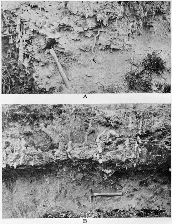
Plate XXVIII--A, Petrified (calcareous) roots in grit and living roots, marked by arrows, about 30 feet above the base of Ogallala at Beecher Island, Yuma county, Colorado. B, Same bed as shown in A with an addition of larger rootlike bodies made of chert. Same locality.
Irregular shaped but usually more or less rounded concretion-like white bodies of limestone, usually with compact cherty core or made of chert alone, were observed in several "mortar beds" of the Ogallala. Usually these bodies are scattered along some particular planes parallel to the zones of cementation, and most of them are associated with the above-described masses of petrified roots. These bodies may be also petrified roots, but the study of them is not advanced enough to warrant a more definite conclusion at present.
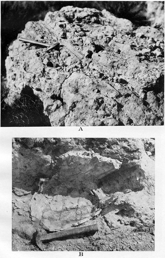
Fragments of white fossilized bones, which clink when struck. with a hammer, are occasionally found in the lower part of the typical Ogallala formation, and a. few localities with better-preserved remains of the vertebrates are found. Remains of a large land turtle were collected by the writer from a bed of bentonitic clay about 25 feet above the base of Ogallala and about 90 feet below the concentrically banded limestone in the SE, sec. 2, T. 12 S., R. 42 W. Remains of another turtle (see Pl. XXIX B) in a large detached mass of typical "mortar bed," in the SE NE, sec. 3, T. 12 S., R. 42 W. were shown to him by Roy Johnston. They came from about 10 feet above the base of the Ogallala and about 90 feet below the concentrically banded limestone. The specific identification of these remains is not yet made, but according to H. T. Martin they undoubtedly belong to the genus Testudo (Xerobites) and are closely related to the big turtles of the Upper Miocene of the Great Plains and those of the Lower Pliocene of Texas, which were described by Cope, Hay and other authors.
An important collection of well-preserved mammalian remains was made by Hesse and assistants of the expedition of the University of Kansas museum in 1930 from the locality discovered earlier in the year by the writer in the SE, sec. 27, T. 12 S., R. 41 W. The local section of the Tertiary is very small, only about 40 feet thick, and consists of practically one "mortar bed" (Pl. XL C) of grit locally with a considerable amount of scattered cobbles in it and greenish sand below it. The bed probably belongs somewhat above the middle of the Wallace County Ogallala. The mammalian remains were found in the sand, which is partly cemented into a very tough rock. According to preliminary identifications by H. T. Martin the following forms were collected:
| Perissodactyls: Pliohippus cf. leidyanus; Aphelops sp. indet. |
| Artiodactyls: Procamelus sp.; Paracamelus sp. |
| Carnivora: Canidae; Acturodon saevus Matthews. |
The presence of Pliohippus cf. leidyanus, according to Martin, places the beds definitely in Lower Pliocene. The presence of the large land Testudo (Xerobites) at the Roy Johnston ranch in beds that belong to about the same horizon in the section is not inconsistent with rating the age of the middle part of the typical "mortar beds" of Wallace County as Lower Pliocene. No identified bones were collected near the base or near the top of the Ogallala of Wallace County, but the unbroken continuity of the formation, which is composed largely of coarse material and is only about 200 feet thick, suggests the possible completion of its sedimentation within the Lower Pliocene.
Bentonitic Clay of the Ogallala
The typical Ogallala section of Wallace County, which is made up largely of pinkish grit with many semicemented "mortar beds" in it, shows a lateral lithologic change in its lower half near the Roy Johnston ranch, in secs. 2 and 1, T. 12 S., R. 42 W. In the basal part of the local exposures of Ogallala there appear beds of fine plastic greenish and maroon-brown bentonitic clays interbedded with soft, dusty grit and sands. A comparatively thick zone of micaceous sand with occasional ripple marks (see Pl. XXV C) and small-scale cross bedding, and with many hard streaks cemented with calcium carbonate, overlies the zone of the clays. The upper part of the sandy zone changes laterally toward the southwest and west into ordinary soft grit and "mortar beds" in which rounded nodules of lime with cherty cores, also hackberry stones and fruits of herbs are common. Farther west the lower part of the sandy zone and the bentonitic clays below it are also replaced by ordinary grit and "mortar beds" of the Ogallala, in which also petrified fruits and limy nodules are occasionally found. East of the Roy Johnston ranch the Tertiary bentonitic clays disappear, but the micaceous sands are still present, resting directly on the Pierre shale. Farther east, in the western and southern parts of Salt Grass canyon, in sec: 2, T. 12 S., R. 42 W., there was apparently a prominent hill in Ogallala time built by the Pierre shale of the minor anticline of Salt Grass canyon in the E2, sec. 12, and SE, sec. 1, T. 12 S., R. 42 W. The top of this pre-Ogallala hill was probably never covered by Ogallala sediments, the typical beds of this formation making a distinct overlap (see Pl. XXIV B; also see geologic cross section Pl. I). This clearly exposed overlap is on the east side of the pre-Ogallala hill. The overlapping beds of Ogallala consist of soft pinkish loam below and loam and grit semicemented into "mortar beds" above. By a gradual addition of new beds from below the Ogallala formation attains its normal thickness for this area of about 80 to 100 feet in the exposures toward the east, where also a considerable thickness of greenish and chocolate-brown plastic bentonitic clays, sandy clays and sorted sands crop out below the typical "mortar beds" of the Ogallala (NW, sec. 8, T. 12 S., R. 41 W.).
Plate XXIV--A, Series of many parallel thin "mortar beds" in sand and loam of Ogallala. In the SW SE, sec. 6, T. 12 S., R. 41 W. B, Unconformity and overlap of Ogallala (To) over the Salt Grass shale member of the Pierre (Ksg). On the upper right side are vertical cliffs of Sanborn loess with lighter arenaceous and calcareous portion at the base. In the SW, sec. 6, T. 12 S., R. 41 W. C, Apparent dip of Ogallala on the south side of Swisegood dome of Willow Creek structure. In the SE. sec. 11. T. 13 S., R. 42 W., looking east.
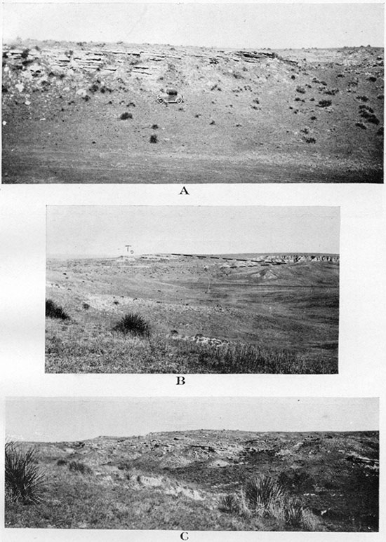
Plate XXV--A, Ogallala hurd stratified and cross-bedded ledge of sorted coarse sand to fine conglomerate. Pleistocene (?) gravel above. In the SW NW, sec. 35, T. 11 S., R. 40 W. B, Same bed in the SW NE, sec. 3, T. 13 S., R. 41 W. C, Ogallala fine semicemented micaceous sand with ripple marks. In the SE NE, sec. 2. T. 12 S., R. 42 W.
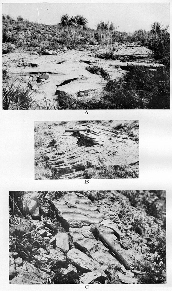
Plate XXVI--A, Ogallala porous limestone with admixture of diatom molds of gastropods (Planorbis and rarely others) and molds of roots (?) B, Ogallala porous limestone with admixture of diatoms and molds of Planorbis.
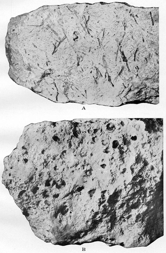
Plate XXVII--A, Cluster of Celtis willistoni stones in Ogallala grit about 50 feet below Chlorellopsis limestone. One-half natural size. In the SW SE, sec. 11, T. 13 S., R. 42 W. B, Celtis willistoni in grit about 15 feet above the base of Ogallala at Beecher Island, Yuma county, Colorado. Natural size. Negative by Charles Rankin. C, Krynitzkia coroniformis Elias, n. sp. Nutlets in calcareous loam about 20 feet above the base of Ogallala at Beecher Island, Yuma county, Colorado. Natural size.
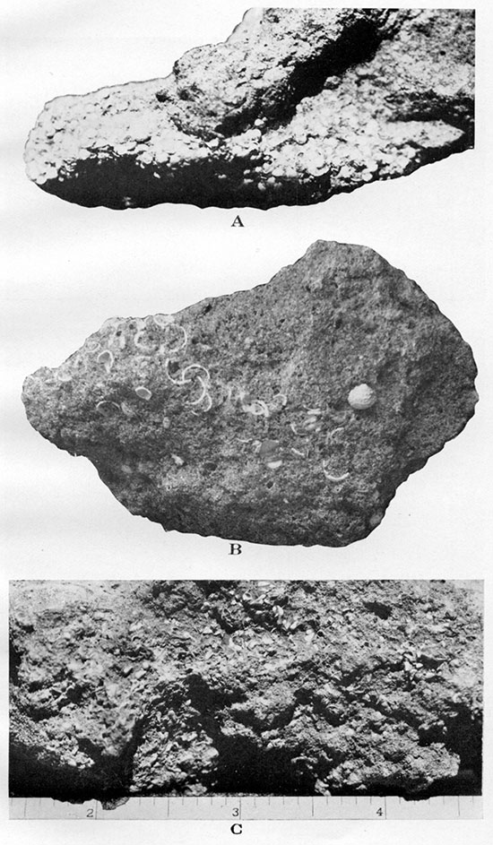
Plate XXIX--A, Mold of bark of a tree (7) in grit of Ogallala. B, Part of carapace of the turtle Testudo (Xerobites) cf. orthopigia in grit about 90 feet below Chlorellopsis limestone of Ogallala. In the NE SE, sec. 3, T. 12 S., R. 42 W.
The exposures of bentonitic clay are grouped west and east of the pre-Ogallala hill of Salt Grass canyon (Fig. 6). An exposure of green clay with white limy nodules and some white soft lime was observed north of Roy Johnston canyon in the NE, sec. 26, T. 11 S., R. 42 W., and south of the same canyon in the SE, sec. 14, T. 12 S., R. 42 W., green and chocolate-brown clays have been found. East of here, on the meridian of Salt Grass canyon, only the Pierre shale is exposed, but farther southeast along the same valley (Collins draw), in the SW, sec. 19, T. 12 S., R. 41 W., there is a considerable exposure of bentonitic clays, which attain here probably their greatest thickness, reaching 30 feet in the south side of the right tributary to Collins draw. In the northern part of the same tributary canyon the clays decrease in thickness from below, and besides are interbedded with sandy clays and sands and pass gradually upward into ordinary loam and grit of the Ogallala. The upper part of the loam and grit is cemented into typical "mortar bed" in which fruits of Biorbia rugosa have been collected, and in the clays below a few fragmentary bones were found. Smaller beds of green bentonitic clay are exposed among the beds of Ogallala grit and gravel in the NW NE sec. 30, T. 12 S., R. 41 W., and in the NW NE, sec. 29, of the same township the green clay outcrops below a bed of white limestone, which contains molds of gastropods. Another small outcrop of bentonitic clay was found in the SW NW, sec. 6, T. 13 S., R. 41 W.
West and southwest of the Guy Woodhouse ranch, in the right tributary canyon on Goose creek, bentonitic clays are also exposed. In the exposure at the head of the canyon in the NW SW, sec. 8, T. 12 S., R. 41 W., green clay with limy nodules is overlain by "mortar beds" and yielded a few fragments of a large turtle carapace and other bones. In the much larger exposures of bentonitic clays at the mouth of the canyon, on the north side of the NW, sec. 8, the thick beds of green clay rest on sand, the top of which is white at the exposure (Pl. XXX A and XXX B) . The green clays pass into chocolate-brown clays toward the top, and the latter are interbedded with loam and gravel (Pls. XXX A and XXX C), which in turn pass gradually upward into ordinary grit of the Ogallala. Near the base of the green clay some fragmentary bones of a rhinoceros and other mammals were collected by the writer, and a tooth Of a horse and a fragment of a camel's jaw were collected here by the expedition of the University of Kansas museum in 1930. This fragmentary material awaits a final identification by a detailed comparison with more complete faunas. According to H. T. Martin the only conclusion that can be made at present is that these bones are hardly older than Miocene and may be as young as Ogallala formation.
Plate XXX--A, General view of type locality of Woodhouse bentonitic clays of Ogallala. For columnar section see Plate XXXIII-3. In the NW NW, sec. 8, T. 12 S., R. 41 W., looking southwest. B, Detail of the same exposure as A. White sandstone is shown at the base of green bentonitic clay. C, Detail of southwestern part of the locality shown in A. Green bentonitic clay below; white streak corresponds to limy nodules and infiltrations; on the top are "mortar beds."
When the writer observed for the first time these bright-colored and plastic clays near the base of typical Ogallala "mortar beds" he was impressed by this definite lower position of the clays in relation to the. mortar beds and by their striking difference in lithology, and was inclined to regard the plastic clays as an older formation than the Ogallala of Wallace County. He named these clays Woodhouse clays, from a locality one mile west of Woodhouse ranch. The contrast of these highly plastic unctuous clays with the nonplastic and calcareous argillaceous members of ordinary Ogallala outcrops, which are unpleasant to touch or, if we may say "dusty," is indeed very striking. So are the bright mottled colors of the clays, the pale green making a vivid contrast with the reddish-brown to chocolate-brown, very different from the monotonous dull (pastel) pink to light-buff and to light-gray colors of ordinary Ogallala beds elsewhere. The absence in the plastic Woodhouse clays of any traces of fine loesslike dust or loam, which is ordinarily an integral part of all coarser and finer sediments of the Ogallala, appeared to be unexplainable except by a hypothesis that the plastic clays have been deposited under different physiographic conditions in a different epoch. It appeared as if these clays might belong to the Oligocene, during which epoch a considerable quantity of clay was deposited in the basin of White river in Nebraska.
The further study of the problem of correlation of the Woodhouse clays led, however, to a different conclusion, and the clays are now regarded by the writer as a local lateral change in lithology of the lower half of the Ogallala formation. The University of Kansas museum has a collection of remains of vertebrates from the Brule clays of Nebraska and the late H. T. Martin kindly supplied the writer with a sample of typical clay in which these remains are imbedded. The comparison of this clay with samples of Woodhouse clays of Wallace County showed but little in common between the two, the clay of the Brule formation being light pink, somewhat porous and not as plastic as the Woodhouse clays. The preliminary examination by Mr. Martin of the remains of vertebrates from Woodhouse clays, as was mentioned above, showed decisively that they do not belong to Oligocene, but they may belong to either Miocene or Lower Pliocene, or to the age of the Ogallala formation of Wallace County.
A sample of Woodhouse clays was sent for preliminary examination to the department of ceramic engineering of the University of Illinois, and the report was : "We have made some examination of the sample which you sent and find that it is probably a bentonite" (from the letter of November 4, 1930, by R. K. Hursh, acting head, Dept. Ceramic Eng., Univ. of Illinois).
The suggestion that the clays are related to bentonite, and thus are probably a product of weathering of volcanic ashes, appears to have support in the mottled coloration of the clays in pale-green and maroon brown. Though some beds are more or less evenly colored with one or the other of these colors, there are nearly always considerable intermediate zones between these beds, which are mottled with irregular greenish spots and bands on a maroon or pinkish-brown ground. The local change of red color to green in sedimentary rocks is ordinarily attributed to the reducing action of organic remains in the rock. However, no traces of organic remains within the greenish spots in these clays could be detected, and it seems to be more probable that the mottled greenish and reddish coloration in this material is due to reaction between gases trapped in the volcanic ash and the ash itself, the clays being most probably the product of the decomposition of the ash. The similar intimate combination of greenish and reddish colors has been frequently observed in tuffs and related volcanic materials of different ages in central and northeastern Asia.
When making the simple water test with the samples of Woodhouse clays from various localities in Wallace County the writer observed that some samples of the clays swelled and disintegrated into fine mud, whereas others did not show these effects at all. It seems to be possible that the clays represent an intimate mixture of altered volcanic ash of the Ogallala with the clayey products of disintegration of the Pierre shale of the pre-Ogallala hill near Salt Grass canyon of today. The Woodhouse clays have been deposited both west and east of this hill. There are no traces of local volcanic activity in this ancient hill or in any other part of western Kansas, but it seems probable that the drifting volcanic. dust from a distant. volcano accumulated on the lee side of this prominent hill in the same way as drifting snow accumulates on the lee side of hills and other obstacles. The writer thinks that the east side of Salt Grass hill of pre-Ogallala and Ogallala times was probably the lee side with regard to the prevailing winds which brought the volcanic dust or "ash" from somewhere in the Rocky Mountain region.
The presence of similar bentonitic clays some distance west of this hill can be explained as due to an accumulation of volcanic dust on the lee side of the next, probably less prominent, hill of the "Weskan anticline" (Fig. 6). This meridianal structural and topographic ridge, which in all probability was formed by differential settling of the sediments over a deep-seated "buried ridge," presented a topographic prominence also in pre-Ogallala and Ogallala times. The distribution of Pleistocene volcanic ashes in western Kansas, according to K. K. Landes, appears to indicate the prevalence of southwesterly winds in this epoch with the source of the volcanic dust in northeastern New Mexico (Landes, 1928, pp. 935-937 or 1928a, pp. 17-19). A bed of unaltered bluish-white volcanic ash was found by the writer in the outcrop of Ogallala southeast of Wallace. This bed is 41h feet thick and is about 76 feet below the topmost Ogallala bed, the concentrically banded limestone, and about 6 feet from the base of the local Ogallala section. Many other localities of Tertiary volcanic ash in western Kansas are described by Landes (Landes, 1928), who also mentions some clays associated with volcanic ash deposits which he thinks may be bentonitic clays (Idem, p. 42). W. L. Russell, who became acquainted with the Woodhouse clays of Wallace County through the writer in 1928, observed that:
"In Rawlins, Graham, Phillips and northern Trego counties there is in places a series of Tertiary strata, which lies beneath the known Ogallala and which differs in appearance from the typical Ogallala. At the base of these pre-Ogallala strata there is a dense, flinty, pinkish- or greenish-gray sandstone with nodules of greenish chert and plentiful pebbles and grains of pink feldspar. Over this there are greenish-gray or pinkish-gray clays and laminated, fine, white micaceous sandstones. Vertebrate fossils are more plentiful in this series than in the typical Ogallala." [Russell, 1929, pp. 599-600]
These beds are possibly equivalents of the Woodhouse clays of Wallace County. As Woodhouse clays most probably represent locally altered volcanic ash, possibly mixed with the clayey products of disintegration of the local Pierre shale, their origin in Ogallala time is no longer puzzling, the presence of beds of volcanic ash in the Ogallala of western Kansas being not a rare occurrence. In many exposures of Wallace County the bentonitic clays are interbedded with ordinary grit and loam of the Ogallala and are replaced laterally by these rocks. The stratigraphic position of these clays in relation to the more typical Ogallala beds of the same and of neighboring exposures is shown in the correlation table, Pl. XXXIII, and on Fig. 5. It appears probable that the Woodhouse clays correspond, at least in their upper part, to the Ogallala of Wallace County, which in turn appears to correspond to the type Ogallala (about 200 feet thick) in Nebraska. The lower portion of the Woodhouse clays, in which the bones of the type locality one mile west of Woodhouse ranch were collected, may be somewhat older than the strictly Ogallala beds and may possibly belong to Upper Miocene. It is possible that the Tertiary clays in the counties east and northeast of Wallace also belong in part to slightly earlier time than the typical Ogallala beds of Wallace County, which are undoubtedly of Lower Pliocene age.
"Rhinoceros Hill" Beds and Diatomaceous Marl of the Ogallala
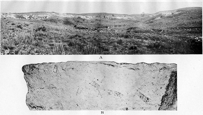
In the northeast part of Wallace County, in the basin of the north fork of Smoky Hill river near the Marshall ranch, a somewhat different type of Tertiary sediments is observed, which according to the rich invertebrate fauna collected in these beds must be contemporaneous with the typical "mortar beds" of Wallace County referred by the writer to the Ogallala. The local Tertiary section, which here reaches 115 feet in thickness, begins with a deposit of grit as much as 100 feet thick. This grit has very thin streaks and nodules of calcium carbonate in 15 to 20 feet of the basal portion, above which is a 3-foot to 4-foot bed of loose and partly cemented graveL Farther up in the grit there is only one slightly cemented bed that resembles closely the "mortar beds," but the bed is not persistent, Stemlike and rootlike remains and calcareous nodules are common in this bed, but no fossil fruits of any kind so common in Ogallala elsewhere were found in it or in neighboring beds of the section. About 10 feet above the bed and apparently conformable with it there lies a ledge of snow-white diatomaceous marl, which forms the most prominent escarpment of the locality (PL XXXI A). The bed of marl is 4 to 11 feet thick and was traced for about 3 1/2 miles along the south side of the valley. A thick lens of greenishgray sand is locally found underneath the marl; and in the upper portion of this sand, almost immediately below the marl, the bones of Lower Pliocene mammals were collected.
Plate XXXI--A, Diatomaceous marl of Ogallala. Exposures west of Rhinoceros Hill on south side of north fork of Smoky Hill river, in the NE SE. sec. 11, T. 11 S., R. 38 W. B, Diatomaceous marl of Ogallala, with flattened cases of caddis worms made of sand grains. Natural size. Same locality.
Microscopic examination and chemical analysis show that the diatomaceous marl is composed of tests of fresh-water diatoms and of flaky calcium carbonate in about equal proportion by volume. The flaky calcium carbonate is made partly of crushed shells of fresh-water gastropods, and to a much less extent those of pelecypods and ostracodes, the larger fragments of which are not infrequently observed along the bedding planes of the marl, and complete shells of which are plentiful in the limestone at the top of the marl.
Among the tests of diatoms in the marl long, thin and smooth spicules of sponges are scattered. This organic material constitutes about nine-tenths of the silica in the marl; the rest of the silica is of inorganic origin and consists of sand grains. These grains are of fine to medium size and are made chiefly of colorless quartz and to a much less extent of pinkish feldspar. A closer megascopic examination of the rocks discloses that these sand grains are gathered close together to form apparently crushed tubes, which resemble closely the caddis-worm cases of larvre of the living caddisflies (Trichoptera). (See Pl. XXXI B.) The aquatic larvre of these insects, which are especially common on the shores of lakes, construct the portable cases, in which they live, of a great variety of materials and very often of sand grains.
Occasionally skeletons and scales of small fishes are scattered in the diatomaceous marl and in the capping limy rocks above it. In the easternmost exposure of the diatomaceous marl, southeast of Marshall ranch, a fragment of a dicotyledon leaf was collected in a somewhat harder part of the rock near the base of the ledge. This leaf undoubtedly belongs to poplar and is closely related to Populus cf. balsamoides Goeppert of the Upper Miocene auriferous gravels of California (Lesquereaux, 1883, Pl. LV, figs. 3-5, especially 5), and to some varieties of Populus alexanderi Dorf from Lower Pliocene of the Pacific coast of the United States (Dorf, 1930, Pl. 7, fig. 3 and others). A careful search through the bed of diatomaceous earth will probably reveal more dicotyledon leaves and other fossils, which will be of considerable scientific interest.
The diatomaceous marl is capped by a thin ledge of white limestone, which is usually full of hollows, representing molds of Planorbis, Physa and rarely of other fresh-water gastropods (Pl. XXVI B) . Above this bed nearly 10 feet of slightly cemented grit was observed, forming the uppermost part of the local Tertiary.
In the greenish-gray loose sand that locally underlies the diatomaceous marl a rich fauna of vertebrates has been collected by expeditions of the University of Kansas Museum of Natural History. The quarry in which the collections were made is situated on Rhinoceros Hill, so named by the head of the expeditions, H. T. Martin, in the SE NE, sec. 11, T. 11 S., R. 38 W., of Wallace County. The following is the list of identified forms kindly supplied by Mr. Martin for this report:
| Perissodactyls: | ||
| Pliohippus cf. leidyanus. | ||
| Protohippus cf. P. secundus. | ||
| Hipparion lenticulare. | ||
| Aphelops. | ||
| Teleoceros. | ||
| Carnivora: | ||
| Mustelidae: | ||
| Brachypsalis marshalli. | ||
| Felidae: | ||
| Pseudaelus. | ||
| Machcerodus. | ||
| Artiodactyls: | ||
| Prosthenops sertus. | ||
| Prosthenops crassigensis. | ||
| Procamelus sp. | ||
| Paracamelus sp. | ||
| Leptotylopus sp. | ||
| Blastomeryx. | ||
| Rodentia: | ||
| Mylogaulus sp. | ||
| Sciurus. | ||
| Carnivora: | ||
| Canidae: | ||
| Boraphagus cyonoides. | ||
| Aelurodon. | ||
| Leptocyon. | ||
| Proboscidians: | ||
| Trilophodon sp. | ||
| Amebelodon fricki. | ||
| Aves: | ||
| Gruss nannodes n. sp. | ||
| Chelonia: | ||
| Testudo sp. | ||
| Reptilia: | ||
| Lacatilia gen. indet. | ||
| Amphibia: | ||
| Annura sp. indet. | ||
| Plioambystoma kansasensis. | ||
The fragments of bones are scattered at several outcrops east and west of Rhinoceros Hill in secs. 10, 11 and 12, T. 11 S., R. 38 W., the remains apparently coming in part from the beds immediately below the diatomaceous marl and a few fragments coming from the grit above the diatomaceous marl. The fauna of Rhinoceros Hill belongs, according to Martin, to Lower Pliocene or to the same age as the above-noted fauna from the base of the typical "mortar beds" in Collins draw, in the SE, sec. 27, T. 12 S., R. 41 W., where also Pliohippus cf. leidyanus was identified. Therefore the "Rhinoceros Hill" beds of the north fork of Smoky Hill river must be considered to be contemporaneous with the "mortar beds" of Wallace County, which are referred to Ogallala in this report. A more exact relation of these beds to the typical Ogallala of southern and western Wallace County is discussed below.
About three miles north and slightly west of Rhinoceros Hill, in the SW, sec. 26, T. 10 S., R. 38 W., in Sherman County, another "sand quarry" in the "fine silty deposit" of the Tertiary was opened by Martin (Adams and Martin, 1929, p. 604), the fauna of which, though closely related to the "Rhinoceros Hill" vertebrates, includes some varieties that are considered by him to indicate a slightly greater age than the latter, though still in the Lower Pliocene. It appears to the writer that these unconsolidated "fine silty" beds of Sherman County, which are called by Martin "Edson beds" (from a small town in Sherman County), must belong somewhere low in the "Rhinoceros Hill" section, probably about 50 to 80 feet below the bed from which the fauna of "Rhinoceros Hill" was collected. The underlying Pierre shale must be not far below the "Edson beds" of Sherman County and at a somewhat lower elevation than the fossiliferous sand of Rhinoceros Hill.
Diatomaceous marl similar to that of the Marshall ranch or "Rhinoceros Hill" deposits was observed by the writer in two more localities toward the southwest. If the diatomaceous marl of these localities can be considered nearly or quite contemporaneous with the bed of the same rock of the Marshall ranch, the "Rhinoceros Hill" beds will correspond to about the middle of the typical "mortar bed" section of Wallace County Ogallala, which appears to be very probable. This correlation is shown in the. table of Tertiary sections on Pl. XXXIII. The white diatomaceous marl outcrops in the southeast corner of sec. 35, T. 11 S., R. 39 W., at the head of one of the many short draws on the south side of Lake creek valley, where it overlies about 20 feet of slightly cemented grit (the locality was courteously shown to the writer by Jas. T. Madigan). The thickness of the poorly exposed diatomaceous marl of this locality appears to be several feet, the quality of the rock being the same as that of the Marshall ranch deposits.
Another deposit of diatomaceous marl, which is slightly darker and is capped by limestone with gradual lateral change to buff-colored chert, was studied in the north-central part of sec. 29, T. 12 S., R. 41 W. Capping limestone and chert are full of beautifully preserved fresh-water gastropods (Planorbis, Physa and others) and pelecypods (Muscilium) , and together with them scales of small fishes and small smooth bean-like shells of ostracodes are often found. The diatomaceous marl is underlain by light-gray clay and sand, below which pinkish grit constitutes the base of the local Tertiary, resting unconformably on Pierre shale, The diatomaceous marl of this exposure and the accompanying thin grayish clay and sand below and chert and limestone above apparently pinch out rapidly. In the next exposure east, only about 100 yards away, the gastropod limestone is underlain by green bentonitic clay. In the next exposures west, south and east of the locality the regular pink grit with "mortar beds" and occasionally with cross-bedded sandstone and conglomerate near the base are exposed. Considering the general decrease of the local Ogallala section, nearly the lower half of it being absent, the base of all these exposures will be probably about 100 feet below the concentrically banded limestone, which is only rarely exposed in the north-central part of Wallace County. The diatomaceous marl of Rhinoceros Hill and surrounding exposures near Marshall ranch appear to belong, also, to about the middle of the Ogallala, and all the exposed beds of the diatomaceous marl in the north-central and northeastern parts of Wallace County may be considered to lie at the same or nearly the same horizon of the section, as they are correlated on the accompanying chart.
Prev Page--Upper Cretaceous Formations || Next Page--Quaternary
Kansas Geological Survey, Geology
Placed on web Nov. 14, 2014; originally published April 1, 1931.
Comments to webadmin@kgs.ku.edu
The URL for this page is http://www.kgs.ku.edu/Publications/Bulletins/18/04_strat3.html