![]()
Prev Page--Chemical quality || Next Page--Well Records
Irrigation Development
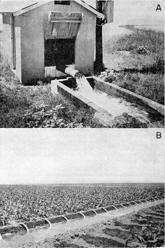
In the Ladder Creek area, irrigation from wells was not practiced extensively until after World War II. In the region to the south, in Scott and Finney Counties, irrigation was common before 1920. Between 1930 and 1940 several irrigation systems were installed north of Scott City, and many small shallow irrigation wells were. drilled in Wichita and Wallace Counties in stream valleys. A typical irrigation system in the Ladder Creek area is shown in Plate 11.
Plate 11--A, Irrigation well owned by S. W. Filson in the NW sec. 36, T. 17 S., R. 33 W., Scott County, pumping at about 1,200 gpm. B, Water from well in A being siphoned from irrigation ditch into rows of corn nearly 3/4 mile northeast of the well.
Since 1940 the practice of intensive agriculture using irrigation from wells to augment the rainfall even in years of above-normal precipitation has been increasing. This permits the raising of such crops as corn, sugar beets, alfalfa, and beans, and the use of irrigated, planted grassland as pasture. Irrigation agriculture yields a greater return than the planting of dry-land crops such as wheat and sorghum but requires the use of more water per unit area. In wet years, the pumping of those wells that irrigate dry-land crops is negligible, but those irrigating high-yield crops will pump large quantities of water even in years of above-normal rainfall.
In recent years the practice of test drilling to select those parts of the aquifer most suitable for well development has preceded the construction of irrigation wells because of the heterogeneous nature of the aquifer and the large range in thickness of the saturated material from nearly none to 160 feet. The wells are drilled chiefly by hydraulic-rotary methods, cased with 16- to 24-inch steel casing perforated throughout most of the saturated zone, and gravel packed to facilitate the flow of water into the casing. Turbine pumps having two to five stages are commonly used, and these are powered by engines using a variety of fuels, chiefly diesel fuel, propane, or butane. The use of electricity and natural gas is restricted to the areas where these sources of power are readily available. Very few gasoline engines are used to power the newer installations.
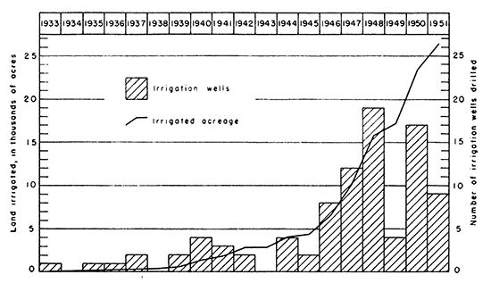
Figure 21 shows graphically the increase of irrigated acreage during the period 1933-51. A series of drought years, or even years of normal precipitation, may stimulate a greatly increased rate of drilling of irrigation wells. The development of groundwater irrigation is related also to the farm economy and to the availability of pumping equipment, but these two factors will probably not adversely affect the use of ground water for irrigation in the near future.
Figure 21--Graph showing irrigation development during 19-year period 1933 to 1951.
Irrigation from wells in the area is still in the initial phases despite the great increase in the acreage of irrigated lands since 1945. The U. S. Bureau of Reclamation has estimated that 435,000 acres of land is suitable for irrigation in the area, of which only about 26,000 acres, or about 6 percent, was developed by the end of 1951. Of this 26,000 acres only 18,000 acres is irrigated annually.
The development of additional ground-water irrigation in the Ladder Creek area depends on the amount of water that can be pumped perennially from the ground-water reservoirs. This amount depends in turn on the long term rate of ground-water replenishment from precipitation, from infiltration from streams, and from movement of ground water into the Ladder Creek area from adjacent areas.
The construction of new wells and the additional development of irrigation from ground water must also be limited to those areas where the saturated water-bearing materials have a fairly large thickness. The saturated thickness of the water-bearing Tertiary and Quaternary deposits overlying Cretaceous bedrock is shown are ally in Plate 5. The isopachous contours showing saturated thickness were prepared by superimposing the water-table contour map (Pl. 4) on the map showing the configuration of the surface of the Cretaceous rocks (Pl. 1) and drawing the contours through points of equal thickness. The water-bearing materials have a thickness of as much as 160 feet in northern Greeley County and southern Wallace County about 12 miles east of the Colorado-Kansas line. Between contour lines representing zero thickness of saturated material the water table probably is absent.
Prev Page--Chemical quality || Next Page--Well Records
Kansas Geological Survey, Geology
Placed on web Jan. 30, 2013; originally published December 1957.
Comments to webadmin@kgs.ku.edu
The URL for this page is http://www.kgs.ku.edu/Publications/Bulletins/126/08_irri.html