![]()
Prev Page--Surface water || Next Page--Chemical quality
Geography
Ground Water
Aquifer Tests
The permeability of water-bearing materials can be determined by laboratory methods (summarized by V. C. Fishel in Wenzel, 1942, p. 56-58) or in the field using the formula developed by Theis ( 1935) and later described by Wenzel (1942, p. 94-96). From the final equation expressing the relation between the drawdown and the rate and duration of the discharge of a well completely penetrating a homogeneous, isotropic aquifer of infinite areal extent, Cooper and Jacob (1946) developed the following formula, converted to gallon-foot-day units:
T = (264Q / Δs) log10 (t2/t1)
where T is the transmissibility in gallons per day per foot; Q is the discharge of the well in gallons per minute; As is the change in drawdown in feet from time t1 to t2 expressed in minutes since pumping began.
The solution of the formula for T is facilitated by plotting on semilogarithmic paper the water-level measurements collected during the pumping period. The time of measurement is plotted on the logarithmic coordinate and the water level on the arithmetic coordinate. The points should plot as a straight line except for extremely small values of t. If log10 (t2/t1) is taken over one log cycle, the value of the logarithm becomes unity, and the value of As will be the difference in water level over one log cycle. The type-curve solution and the Theis recovery formula were used to check the results obtained by the preceding method.
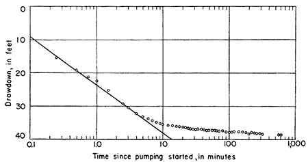
Well 16-35-31da, an irrigation well in the Ogallala formation and owned by H. O. Burns, was pumped approximately 2,000 minutes beginning on August 23, 1952. During pumping and recovery periods, water levels in the pumped well were measured by an electric water-level gage. The measurements are given in Table 10. The rate of discharge as measured by a Collins flow gage averaged 810 gallons per minute. Maximum drawdown was 38.41 feet, and the specific capacity of the well was 22 gpm per foot of drawdown. A rate of 840 gpm was measured during the early part of the test and was used in computing the transmissibility from the graph (Fig. 6) because 840 gpm probably approximated the yield when the curve of water level versus time followed a straight line. The transmissibility was computed at about 15,000 gpd per foot.
Figure 6--Graph of drawdown in well 16-35-31da owned by H. O. Burns.
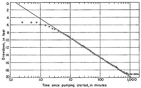
Well 17-34-2dc, an irrigation well in the Ogallala formation and owned by C. W. Watkins, was pumped for about 30 hours beginning on October 8,1951. Water levels in the well were measured during pumping and for 40 hours after pumping ceased. The measurements are tabulated in Table 13. The rate of discharge as measured by a Collins flow gage averaged 744 gpm, the maximum drawdown of water level was 19.15 feet, and the specific capacity of the well was about 39 gpm per foot of drawdown. The pumping rate during the period when the drawdown curve approximated a straight line was 762 gpm, and this yield was used in computing a transmissibility of about 40,000 gpd per foot from the plot of the drawdown data (Fig. 7). The plot obtained from the recovery data was not sufficiently near a straight line to permit use of the Theis recovery formula.
Figure 7--Graph of drawdown in well 17-34-2dc owned by C. W. Watkins.
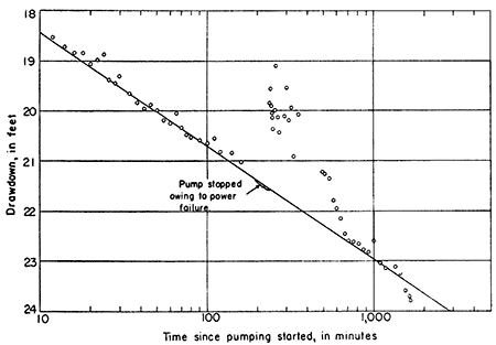
Well 18-32-7ac, an irrigation well in the Ogallala, Sanborn, and Meade formations and owned by S. W. Filson, was pumped for more than 27 hours beginning on August 28, 1951. Water levels in the pumped well were measured during the pumping period and for 15 1/2 hours after pumping ceased. The measurements are given in Table 14. Discharge averaged 1,170 gpm as measured by a Collins flow gage, maximum drawdown was 23.71 feet, and specific capacity of the well was 49.4 gpm per foot of drawdown. Power failure stopped the pump for 40 minutes during the test, and an average discharge of 1,140 gpm, which takes into consideration the period of zero discharge, was used to compute the transmissibility. A transmissibility of about 130,000 gpd per foot was computed from the plot of the drawdown data (Fig. 8), which checked closely with values obtained from the type-curve and Theis recovery methods.
Figure 8--Graph of drawdown in well 18-32-7ac owned by S. W. Filson.
Aquifer tests were made using well 17-32-5ab, owned by Mrs. Estes Christy, and well 17-33-28cd, owned by Lloyd Stockwell. The water-level measurements collected during these tests are tabulated in Tables 11 and 12. The values for transmissibility that were obtained could not be checked by another method; hence these two tests are not regarded as reliable.
Performance data for all the tests are summarized in Table 4. The transmissibility values for the Ogallala formation obtained from the two most reliable tests are 15,000 and 40,000 gpd per foot. The value for transmissibility for the combined Ogallala, Sanborn, and Meade formations is 130,000 gpd per foot.
Table 4--Results of aquifer tests.
| Well Number | 16-35-31da | 17-32-5ab | 17-33-28d | 17-34-2dc | 18-32-7ac |
|---|---|---|---|---|---|
| Aquifer | Ogallala | Ogallala | Ogallala | Ogallala | Ogallala, Meade, and Sanborn |
| Drawdown at end of test (feet) |
36.10 | 23.39 | 36.44 | 19.10 | 23.67 |
| Average discharge (gpm) |
810 | 450 | 775 | 744 | 1,170 |
| Duration of pumping (minutes) |
2,000± | 1,480 | 660 | 1,805 | 1,651 1/2 |
| Specific capacity (gpm per foot of drawdown) |
22.5 | 19.3 | 21.3 | 38.8 | 49.4 |
| Transmissibility (gpd per foot) |
15,000 | 40,000 | 130,000 | ||
| Saturated thickness (feet) |
102 | 100 | 100 | 90 | 165 |
| Permeability (gpd per square foot) |
150 | 440 | 800 |
Depth to Water
The measured depths to water range from slightly less than a foot to 246 feet (Pl. 2). The greatest depth to water is near the western edge of the area. The depth to water is generally less than 20 feet in the flood plains of the effluent streams and in the topographical depressions near Scott City. The water table is between 80 and 150 feet deep below most of the upland area and between 20 and 80 feet deep below the upland plain adjacent to effluent streams.
The depths to water in Chalk and Twin Butte Creek valleys and in the small tributary valleys of Smoky Hill River are 10 to 20 feet. In a few wells in southern Logan County, depth to water is less than 75 feet. In Ladder Creek valley westward from the Wichita-Greeley County line the depth to water is greater, reaching a maximum of 140 feet below the channel near the Colorado-Kansas border.
Configuration of the Water Table and Movement of Ground Water
The configuration of the water table in the Ladder Creek area is shown in Plate 4 by means of contours referred to sea level. These contours are based on measurements of water levels in wells during the period May-August 1951. The configuration of the water table is determined chiefly by: (1) the shape of the underlying aquiclude; (2) local differences in permeability in the aquifer; ( 3) ground-water discharge into streams; (4) variations in the amount of recharge from precipitation that infiltrates through ephemeral stream valleys, depressions, and upland plains; and (5) discharge from wells.
The principal feature of the shape of the water table in the area is an eastward slope approximating the slope of the land surface and the buried surface of the Cretaceous rocks. The slope is about 10 feet per mile in western Wallace and Greeley Counties. From the middle of Greeley County east to the middle of Scott County the slope is nearly 13 feet per mile, and from here to the middle of Lane County, the slope is again 10 feet per mile.
Several unusual features contrast with the generally smooth easterly slope of the water table in the Ladder Creek area. One is an isolated water-table high, just east of the Lake McBride area, which is due to localized recharge from extensive upland plains that lack surface drainage. A second irregular feature is a general flattening of the water table in the vicinity of Scott City due to the presence of the permeable Pleistocene sand and gravel deposits. Another contributing factor may be a north-trending ridge on the Cretaceous surface, which may act as a barrier to the eastward movement of ground water.
In southwestern Wallace County, saturated materials are thin or absent, but not enough information is available to delineate the area accurately. The general shape and location are shown on Plate 5. Higher recharge from the present valley in the area probably is responsible for the presence of ground water in the vicinity of well 15-42-16ad.
In the western part of the Ladder Creek area the water-table contours are convex downstream at their crossing of certain minor upland drainage ways, indicating localized recharge in these areas. Examples are shown in T. 16 S., R. 40 W., and in T. 15 S., R. 39 and 40 W. (Pl. 4).
The movement of water in the zone of saturation, or groundwater reservoir, is perpendicular to the contours drawn on the water table. Plate 4 shows that, except for local minor variations, ground water moves eastward in the Ladder Creek area. In areas adjacent to Ladder Creek in Wichita County, the water table slopes slightly to the northeast or southeast and contributes a small amount of water to Ladder Creek. In the western part of Scott County the water table slopes eastward at approximately the same gradient as Ladder Creek valley, and the gain in streamflow from ground water is negligible. Downstream from the point where the stream starts its northward path in the central part of Scott County, however, the ground-water contribution to the stream increases rapidly. In this section the stream flows below the level of the water table. The rate of movement of ground water in the Ogallala formation, estimated from data of the aquifer tests, probably ranges from about 40 to 400 feet per year.
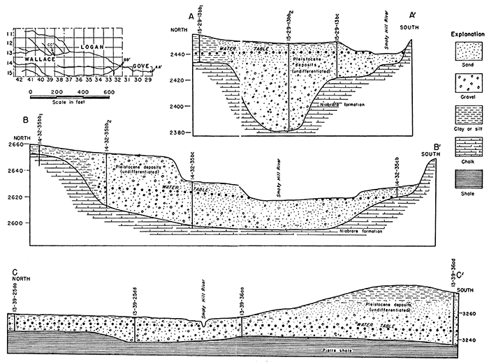
In the Ladder Creek valley a fill of alluvial sand and gravel overlies the Ogallala formation. Although no test or quantitative data are available on the permeability of this sand and gravel, it is probably more permeable than the Ogallala materials. The test holes drilled in the Smoky Hill River valley penetrated large quantities of clean, coarse, saturated sand and gravel of relatively high permeability. Slichter (1905, p. 5) determined the average rate of movement of the underflow in similar deposits with similar water-table gradients in the Arkansas River valley to be 8 feet per day. By use of this figure for the velocity in the Smoky Hill River valley, the movement of water across section A-A' (Fig. 9) is computed to be approximately 1 cfs. Less water moves across the sections near Elkader and Wallace (Fig. 9, sections B-B' and C-C').
Figure 9--Geologic cross sections across Smoky Hill River valley.
Fluctuations of the Water Table
The water table fluctuates in response to recharge to or discharge from the ground-water body either by natural or by artificial means. Changes in atmospheric pressure also cause minor fluctuations in water level. In the Ladder Creek area typical long-term fluctuations in the water table are shown by the hydrographs of Figure 10. Well 18-33-12ad shows a gradual decline of water level from a depth of about 44.0 feet below the land surface in 1939 to 58.0 feet in 1949. After 1949 the water level rose sharply to a depth of 45.0 feet at the beginning of 1952. Well 18-33-12ad is an irrigation well, but it has not been pumped much in recent years. The water level in this well is affected by pumping other nearby irrigation wells. In well 16-34-18dd the water level in 1951 was within 0.2 foot of the average water level for 1939, but records for most of the intervening period are lacking. This well is in an area of negligible pumpage for irrigation.
Figure 10--Hydrographs showing fluctuation of water levels in wells in the Ladder Creek area.
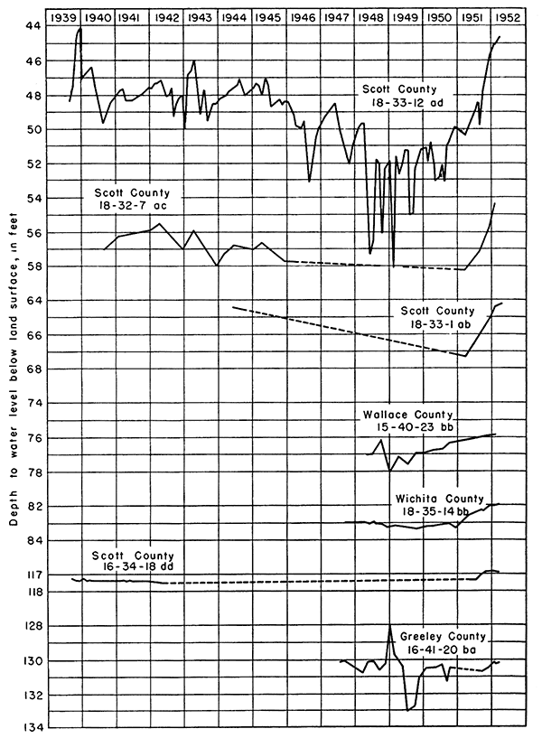
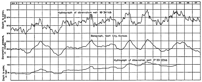
Figure 11--Comparison of water-level fluctuations with changes in barometric pressure from January 4 to 27, 1952.
The water levels in most wells throughout the area were higher in 1952 than at any previous date of measurement, indicating that excessive precipitation in 1951 added more water to the groundwater reservoir than was discharged in the same period. Similarly, the gradual decline in well 18-33-12ad until 1949 represents a decrease in storage as a result of pumping for irrigation. A decline during this same period is evident in other wells near Scott City, where many irrigation wells have pumped water during part of the year.
Fluctuations in water level due to changes in atmospheric pressure are illustrated in Figure 11. Well 18-34-1cb2 is an unused irrigation well having a depth to water of 97.5 feet and a total depth of 160.7 feet. The loess cover and adjacent impermeable beds in the Ogallala in the vicinity of this well form a reasonably effective confining layer virtually sealing the underlying aquifer. Changes in atmospheric pressure are exerted on the aquifer through the loess cover and impermeable beds in the Ogallala but are damped and are therefore less effective than the direct pressure changes applied to the water level in the open well casing. As a result, the water level in the well fluctuates as a partially effective barometer. The magnitude of this effect is appreciable in well 18-34-1cb2, but in well 17-33-22bb, which is situated in Ladder Creek valley on a knoll of Ogallala materials that has no loess cover, the barometric effect is slight.
Recharge to Ground Water
Of the total precipitation that falls on the land surface, some is evaporated directly into the atmosphere, some is stored temporarily in the soil whence it subsequently evaporates and transpires, some runs off in surface streams, and some infiltrates to the zone of saturation and recharges the ground water.
In the Ladder Creek area, recharge results from infiltration into the aquifer in several different ways. Some water from precipitation percolates downward directly from the surface on which it falls. Some of the precipitation first collects in shallow undrained depressions and then percolates down to recharge ground water. Influent seepage from streamflow in the channels above the water table adds considerable recharge to ground water.
Infiltration acts under the force of gravity and molecular attraction. It is dependent upon the size and characteristics of soil particles and the duration and intensity of precipitation. Coarse-grained soils composed of sandy materials generally permit greater infiltration than fine-textured soils. Soils rich in organic content and uncultivated soils generally are favorable to infiltration. The rise in the water table due to recharge lags behind the rainfall because of the time required for the rainfall to infiltrate the soil and move downward to the water table. Recharge may occur upgradient on the water table from a well, and hence considerable time may be required for the recharge to affect the water level at the well.
In the uplands of the Ladder Creek area, runoff is low and water collects in the undrained depressions, from which some water evaporates and some infiltrates slowly into the underlying formations. On the upland surface, the depressions are the most favorable areas for recharge from infiltration and percolation. The central parts of the smaller depressions may be underlain by relatively impermeable compact soil and silt that permit little or no recharge by infiltration. In some ponds, the water may be completely evaporated. When heavy precipitation fills the depressions with water beyond the central silted area, however, recharge may be considerable. The larger depressions seem to admit water through seepage more readily than smaller ones. Probably much of the loess cover has been removed by erosion from the large depressions, and water infiltrating down has a more direct connection with permeable materials below. Evidence of recharge from depressional areas is demonstrated in the hydrograph of well 18-33-12ad (Fig. 10), which is situated in such an area.
A discussion of recharge in depressions in Scott County was previously presented by Waite (1947, p. 70-72). He referred to the work of White, Broadhurst, and Lang (1940), who made a study of similar depressions on the High Plains in Texas. From study of several hundred test holes in these depressions, White, Broadhurst, and Lang (1940, p. 7) found the following conditions:
. . . The bottom of most of the depressions is covered with deposits of silt and soil, in places resembling gumbo and ranging from 2 to 10 feet in thickness. After the ponds become dry, fractures and crevices several feet in depth frequently develop in their beds. In some of the depressions small sinks, apparently developed by solution channelling in the underlying caliche deposits, are present. These crevices and solution channels may provide a pathway for the downward movement of water for a time after the ponds are filled, although they may become sealed after water has stood over them for several days. . . . In some of the ponds the rate of decline was small and apparently was due mostly to losses from evaporation. In others, it was quite rapid, amounting in some cases to 2 inches or more a day for 10 days or so after the rains and then gradually slowing down. . . .
The beds of caliche such as were found under some of the Texas depressions are not present in the Ladder Creek area. Recharge from ephemeral ponds in the depressions in the western part of the area affects the water table (Pl. 9) of the Ladder Creek area. During the spring of 1952 the water table would probably have shown more bulges than are indicated by the contours on Plate 4 owing to the effects of recharge from depressions filled by the heavy rains in 1951, but most of the water-level measurements upon which the contour map was based were made before the heavy rains in May and June 1951. Only a part of the measurements in Wallace and Greeley Counties were made in July and August, after the heavy rains.
Recharge to alluvium in stream valleys is greater over a unit area and more immediate in its effect on the water table than recharge on the upland surface. There is no loess mantle to impede infiltration, and soils developed on the relatively coarse alluvial materials are generally more permeable than upland soils. Heavy precipitation may cause recharge within several hours after a rain or, at most, within a few days in valley bottoms of the Ladder Creek area. On the sloping valley walls most of the rainfall becomes surface runoff unless soil and vegetation conditions are optimum for infiltration.
The annual recharge to ground water in western Kansas, and the High Plains generally, has received considerable attention by many hydrologists. Theis (1937) has shown that in the southern High Plains the average annual ground-water recharge is less than half an inch. In parts of Haskell, Cray, Seward, and Finney Counties recharge is computed to be about 0.27 inch annually (Frye, 1942, p. 66). Frye's computation is based on the assumption that recharge is equal to discharge from the aquifer, storage remaining constant.
In the Ladder Creek area the only readily determinable groundwater discharge is the streamflow in Ladder Creek. For 1951, discharge from wells was relatively small and may be disregarded. Discharge by springs and seeps that do not reach the stream and by evapotranspiration from the aquifer not affecting streamflow was not measurable. The Ladder Creek drainage basin has an area of approximately 1,385 square miles. Much of the upland area is undrained and runoff is low. The daily mean flow of Ladder Creek for the period April 1951 to April 1952 was 98 cfs. Of this, 83.7 cfs was estimated to be direct runoff and 14.3 cfs was groundwater runoff. The amount 14.3 cfs represents the discharge from the aquifer and, therefore, is approximately equal to the recharge if it is assumed that storage remains constant. The total 1951 precipitation, averaged for Scott City, Leoti, and Sharon Springs, was 26.90 inches. Computations based on these figures indicate that the quantities involved in the water budget of the Ladder Creek area during 1951 were of the order of magnitude given below.
| Inches | |
|---|---|
| Evapotranspiration | 25.94 |
| Direct runoff | .82 |
| Recharge (ground-water runoff) | .14 |
| Total | 26.90 |
In 1951 the recharge was somewhat higher than indicated above, and the storage in the aquifer increased. The aquifer in the Ladder Creek area is also replenished by ground-water inflow from the west; hence precipitation west of the area also contributes an undetermined quantity of water. Similar computations based on streamflow records for the upper Smoky Hill River basin at Elkader for a drainage area of 3,555 square miles give a recharge figure of 0.16 inch (approximately 1/6 inch) for 1951 and a smaller amount for a normal year.
Recharge from the return of water applied to the land for irrigation is estimated to approach 25 percent of the applied water in the Safford Basin, Arizona (Turner and others, 1941). In that locality the irrigation water is distributed in relatively long ditches over alluvial soils that are probably very permeable. Inasmuch as the upland plain in the Ladder Creek area is thickly mantled by loess and has a dense soil, recharge probably does not exceed an average of 10 percent of the applied water. On the irrigated lands in the flood plain of the area where the soils are more sandy and flooding of hay crops is practiced, the percentage of applied water that recharges the aquifer is likely to be somewhat greater.
Discharge of Ground Water
In the Ladder Creek valley, ground water is discharged from the zone of saturation by (1) evaporation from the water table where it is close to the land surface, (2) transpiration by vegetation, (3) discharge through springs and seeps, (4) discharge into surface streams, (5) withdrawal by wells, and (6) movement underground from the area.
Where the water table lies within a few feet of the land surface, ground water may evaporate from the capillary fringe overlying the zone of saturation. Where the water table lies within a few inches of the land surface, water may evaporate directly from the zone of saturation, especially from porous loose soils on warm dry days.
The flood plains of streams and dry stream channels in the Ladder Creek area are particularly favorable for such evaporation. In upland areas evaporation from the zone of saturation is not possible, owing to the fact that the water table is several feet below the land surface. The amount of water evaporated directly from the groundwater reservoir is probably small compared to other means of ground-water discharge.
During the growing season, plants transpire ground water extensively in the major stream valleys in the area. In the Ladder Creek valley, cottonwood trees and many scattered fields of alfalfa transpire sufficient quantities of water to dissipate several inches, or even several feet, of water from storage in the aquifer adjacent to the stream channel. The lowering of the water table by transpiration greatly reduces the ground-water discharge into the stream, and the streamflow during the growing season in much of the area is chiefly direct runoff from storms. The base flow in the channel increases markedly in the fall and winter when transpiration ceases. Transpiration does not occur from the water table underlying upland areas, but the soil moisture lost by transpiration on the uplands must be replaced before any water can percolate downward to the water table.
The quantity of ground water discharged through springs and seeps in the Ladder Creek area is large but not accurately determinable. Data for several springs in the area are given in Table 5.
Table 5--List of springs in the Ladder Creek area.
| County and Location |
Type | Water-bearing formation |
Underlying impermeable formation |
Topography | Openings | Yield in gpm* | Stream valley | Quality or remarks |
|---|---|---|---|---|---|---|---|---|
| Logan 13-37-23bb |
Contact | Pleistocene | Niobrara | Edge of terrace | Numerous seeps |
60-65 M | Smoky Hill | Formerly domestic supply (Hinshaw Spring) |
| Wallace 13-41-15da 13-41-14cb |
Contact | Pleistocene | Pierre (?) | Valley | Numerous seeps |
10 E | Smoky Hill | |
| Wallace 13-42-23d |
Depression and contact |
Pleistocene | Pierre | Stream channel |
10-15 | 50-75 E | Smoky Hill | Flowing since 1901 at least |
| Wallace 14-39-8a |
Contact | Pleistocene | Pierre | Draw in rolling upland |
Numerous seeps |
Rose Creek | ||
| Wallace 14-39-9bb |
Contact | Ogallala | Pierre | Draw in rolling upland |
Numerous seeps |
0.5-1.0 E | Rose Creek | |
| Wallace 14-39-17 14-39-20 |
Contact | Pleistocene Ogallala |
Pierre | Valley | Numerous | Rose Creek | ||
| Logan 15-33-5cd |
Depression | Pleistocene | Valley floor | Numerous | Twin Butte Creek |
Poor quality reported | ||
| Logan 15-34-28cd |
Depression | Pleistocene | Valley floor | Numerous | Chalk Creek | Occasionally dry in summer | ||
| Lane N2 16-30-20 |
Contact ? | Valley | Hell Creek | See Prescott, 1951, p, 49 |
||||
| Scott 16-33-1cc |
Contact | Ogallala | Niobrara | Valley slope | Ladder Creek | Public supply | ||
| Scott 16-33-12ca |
Contact | Ogallala | Niobrara | Valley | 2 | 50 R | Ladder Creek | See Waite, 1947, Table 19. Formerly domestic use |
| Scott 16-33-13ba |
Contact | Ogallala | Niobrara | Valley | Numerous | 400 R | Ladder Creek | See Waite, 1947, Table 19. Public supply (Big Springs) |
| Scott 16-33-13bd |
Contact | Ogallala | Niobrara | Valley | Ladder Creek | Barrel Springs | ||
| Wichita 16-35-3 |
Depression | Pleistocene | Ogallala | Valley | About 75 | 70-80 E | Chalk Creek | Flowing at least since 1901 |
| Scott 17-33-15ac |
Depression Contact |
Ogallala | Impermeable clay in Ogallala |
Stream channel |
Numerous | 2-3 E | Ladder Creek | |
| Scott 17-33-15ab |
Depression | Ogallala | Valley | Concealed in pool |
Ladder Creek | |||
| Scott 17-34-17dc and 17cd |
Depression | Pleistocene | Stream valley |
Numerous | Ladder Creek | |||
| * M, measured; E, estimated; R, reported | ||||||||
Springs occur at several places in the upper parts of Chalk and Twin Butte Creek valleys where the land surface and water table intersect. A spring in sec. 23, T. 13 S., R. 42 W., occurs at the origin of effluent flow in South Fork of Smoky Hill River. Downstream this flow is frequently dissipated by evapotranspiration and by seepage into sandy channel deposits. Local residents report that flow from the springs has been continuous at least since 1901. Two springs in Ladder Creek valley, 17-34-17dc and 17-33-15ac, can be classified as depression springs. In spring 17-34-17dc water issues from the Ogallala formation and in spring 17 -33-15ac from alluvial valley fill, at points where the water table intersects the land surface. Probably there are other similar springs in the Ladder Creek valley.
Springs occur at many localities where the contact between the Ogallala formation and the underlying impermeable chalk of the Niobrara formation or the Pierre shale has been exposed by erosion. Such springs are found in Rose Creek valley and along Eagle Tail Creek, which flows through Sharon Springs. The springs along Ladder Creek in the Scott County State Park issue from the Ogallala formation at its contact with the underlying impermeable Niobrara formation. One of these, called the Big Spring, is reported to yield 400 gpm. In the Lake McBride area in the Scott County State Park, the discharge of Ladder Creek increases considerably, owing in part to the increments of flow from springs in the main valley and similar smaller springs along tributary canyons. A part of the increase in streamflow in this area, however, probably results from movement of water from the Ogallala formation into the alluvial fill of the valley and thence into the stream.
Many springs rise in other tributaries of Smoky Hill River, particularly in Hell and Salt Creeks in the eastern part of the area. The contribution from the Ogallala formation by such spring discharge to the flow of Smoky Hill River east of Ladder Creek is considerable.
In the Lake McBride area some water from the ground-water reservoir is discharged to Ladder Creek through the alluvium. The zone of saturation contributes ground water to the entire effluent length of the stream in this manner. If this contribution to the stream flow is ultimately diverted by pumping for irrigation, there will be no base flow, and direct runoff alone, then, will constitute the discharge of the stream. Throughout the effluent part of Ladder Creek most of the ground-water discharge comes from the zone of saturation in the alluvium in the valley. Alluvium of the Ladder Creek valley has a maximum width of about 2,000 feet. The alluvial fill in the valley is 20 to 30 feet thick at the north end of Lake McBride and as much as 30 feet thick in western Scott County and in Wichita County. In a few places the alluvium is very thin or absent, and the Ogallala formation is exposed.
Withdrawal of ground water by wells in the Ladder Creek area is increasing annually. By the end of 1951, irrigation wells in the Ladder Creek area numbered 91. The total area irrigated was about 18,000 acres, and in a year of normal rainfall each irrigated acre requires approximately 1 acre-foot of water. Withdrawal of ground water by domestic and stock wells is negligible in comparison to withdrawal for irrigation. Leoti and Sharon Springs are the only cities in the area that use ground water for public supplies.
Discharge by underflow in the alluvium of Smoky Hill River at the eastern boundary of the area probably amounts to less than 1 cfs or less than 726 acre-feet per year.
Prev Page--Surface water || Next Page--Chemical quality
Kansas Geological Survey, Geology
Placed on web Jan. 29, 2013; originally published December 1957.
Comments to webadmin@kgs.ku.edu
The URL for this page is http://www.kgs.ku.edu/Publications/Bulletins/126/06_grou.html